Cryosphere glossary
the volume of fluid passing through a unit cross section in unit time under the action of a unit hydraulic potential gradient.
the ratio of the hydraulic conductivity and the storage capacity of a groundwater aquifer.
artificial thawing (and removal) of frozen ground by the use of a stream or jet of water under high pressure.
a layer or body of cryotic (but unfrozen) ground in a permafrost area, maintained by moving mineralized groundwater.
hierarchical designation consisting of two additional digits for each level of specificity; established by the US Geological Survey to delineate portions of the United States based on surface features related to the distribution and movement of water. The HUC system divides the United States into 21 two-digit regions, 222 four-digit subregions, 370 six-digit basins, and smaller regions designated by additional digits.
any product of condensation or sublimation of atmospheric vapor, whether formed in free atmosphere or at the earth's surface; also any water particles blown by the wind from the earth's surface.
a layer or body of noncryotic unfrozen ground in a permafrost area, maintained by moving groundwater.
an instrument which measures the water vapor content in the atmosphere; there are several different means of transduction used in measuring this quantity and hence various types of hygrometers; these are: a) the psychrometer, which utilizes the thermodynamic method; b) the class of instruments which depends upon a change of physical dimension due to absorption of moisture (hair hygrometer, for example); c) those which depend upon condensation of moisture (dew point hygrometer); d) the class of instruments which depend upon the change of chemical or electrical properties due to absorption of moisture, and some others.
the region covered by sea ice, typically given in square kilometers. For a grid cell, it is the area of the portion of the cell covered by ice. For an entire hemisphere, it is the total area covered by ice, which corresponds to sum of the area of each cell multiplied by the fractional concentration for that cell.
white glare on the underside of low clouds indicating presence of ice which may be beyond the range of vision.
a dome-shaped mass of glacier ice that spreads out in all directions; an ice cap is usually larger than an icefield but less than 50,000 square-kilometers (12 million acres).
Image

Ellesmere Island, Canada
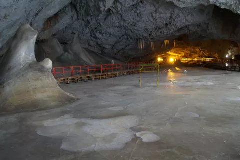
a natural bedrock cave that contains year-round ice.
Image

This photograph shows a 22-meter thick ice block along with ice stalactites and stalagmites in the Great Hall of Scarisoara Ice Cave, Romania.
Aurel Persoiu
a concentration of sea ice, covering 100's of square kilometers, which is found in the same region every summer.
the fraction of an area that is covered by sea ice. Ice concentration typically is reported as a percentage (0 to 100 percent ice), a fraction from 0 to 1, or sometimes in tenths (0/10 to 10/10).
a core sample drilled from the accumulation of snow and ice over many years that have recrystallized and have trapped air bubbles from previous time periods, the composition of which can be used to reconstruct past climates and climate change; typically removed from an ice sheet (Antarctica and Greenland) or from high mountain glaciers elsewhere.