Get Started with NSIDC Data
Get Started with NSIDC Data
NSIDC’s website provides an intuitive design that allows for scientists, policymakers, and educators, regardless of their background, to explore and access data related to the cryosphere. Read on for tips on how to start exploring data on NSIDC.org, and how to receive help and other resources when you need it.
Frequently asked questions
What types of data does NSIDC provide?
The National Snow and Ice Data Center (NSIDC) data management programs focus on preserving, documenting and providing access to over 1400 data sets related to the cryosphere - the snow and ice-covered regions of the world. NSIDC also regularly produces data analysis blogs focused on sea ice, ice sheets and snow, and works with data producers and users to create and publish tools and resources that make the data more accessible to a wide user base. Types of data include cryospheric and related geophysical data from Earth-observing satellite missions, airborne surveys, field observations, weather stations, historical records, and data rescue projects.
Who can use NSIDC data?
NSIDC data is available for free to anyone, including researchers, educators, students, policymakers, and members of the public.
- Most data sets require some prior experience with previous data analysis and programming knowledge.
- For most data sets it is helpful to have some prior experience working with commonly used scientific data formats (e.g. GeoTIFF, NetCDF, or HDF) and software for reading them such as QGIS/ArcGIS, Panoply or HDFView.
- Most of our data sets have user guides to provide guidance.
- If you have any questions about the data we are here to help, just click on the ‘Support’ button on any page of the website and submit your question and we’ll respond promptly
We also have some interactive data graphics that are more accessible to a broader audience.
Are NSIDC data free to use?
All data on NSIDC.org are free of charge and easily available online. Most, but not all of the data provided by NSIDC are also open access, meaning anyone is free to access, use, modify, and share it.
The NASA Earth science data managed by NSIDC does require you to register for a free NASA Earthdata Login user account. Such requirements will be indicated on the data set landing page, and you can register for a free NASA Earthdata Login account at any time. Your account gains you access to all NASA Earth science data at NSIDC and all other NASA Distributed Archive Access Centers (DAACs).
How do I cite the data?
While all data provided through NSIDC’s website are free to access, you must cite all use of data products. Citing sources correctly helps our user community maintain transparency, openness, and trust, while also providing a benefit of being able to track the data impact on scientific research. All NSIDC data sets have a Digital Object Identifier (DOI). On each data set landing page, you will see a Citation icon (see screenshot below) at the top. Simply click on this to see the DOI of the data set, select your preferred Citation Style, then click the “Copy Data Citation '' button and paste it into your research paper or other document.
How are NSIDC data managed?
Three core data management programs are responsible for managing all of the data in NSIDC:
- NASA National Snow and Ice Data Center Distributed Active Archive Center (NSIDC DAAC)
- NOAA@NSIDC
- Exchange for Observations and Local Knowledge of the Arctic (ELOKA)
NSIDC is also a CoreTrustSeal-certified Regular Member of the World Data System (WDS), signifying that NSIDC provides reliable, high-quality data services. CoreTrustSeal is an international, community-based, non-governmental and non-profit organization that identifies sustainable and trustworthy data infrastructures through a rigorous certification process.
Are there data I can look at without doing my own analysis?
NSIDC maintains several products that provide a visual overview of data in a particular region or geophysical measurement of the cryosphere. These products are very popular among scientists, journalists, policymakers, and the general public alike, as they offer the best way to observe some of the information that can be gained from the use of NSIDC data – without having to access, download and analyze data yourself.
Featured products and tools include:
- Sea Ice Index
- Provides a quick look at Arctic-wide changes in sea ice. Sea Ice Index has been a source for consistently processed ice extent and concentration images and data values since 1979
- Charctic Interactive Sea Ice Graph
- Graphs Arctic and Antarctic Sea Ice Extent over various time periods.
- Multisensor Analyzed Sea Ice Extent - North Hemisphere (MASIE-NH)
- Gives a view of Northern Hemisphere-wide sea ice coverage since 01 Jan. 2006
- Browse Image Subset Tool (BIST)
- Provides a tabular format with images that allows you to compare trends and anomalies in the Arctic over time using five different NOAA@NSIDC Arctic sea ice products.
- Satellite Observations of Arctic Change (SOAC)
- Contains interactive maps exposing NASA satellite data and research on Arctic change
- Ice Sheets Today
- Provides near-real-time analysis of the melt seasons for the Greenland and Antarctic ice sheets, including tools for plotting and viewing surface melt extent
- Snow Today
- Daily images and data showing snow cover for the western U.S.
Many of these products are easily accessed via the Interactive Data Graphics page.
Our interactive data graphics represent only some of countless ways NSIDC data can be utilized.
Does NSIDC have Arctic sea ice analyses and data?
NSIDC manages several websites that provide data and scientific analyses for sea ice, ice sheets and snow. These include:
- Sea Ice Today
- Monthly scientific analysis and daily images on Arctic sea ice conditions
- Ice Sheets Today
- Written analysis and data and analysis tools describing the Greenland Ice Sheet melt season and the Antarctic Ice Sheet melt season
- Snow Today
- Daily images and monthly analysis on Arctic sea ice conditions
You can also search the NSIDC data catalog to access the data directly for your own use.
How do I get NSIDC data?
Searching for NSIDC data
To explore NSIDC data, the best place to start is on our Explore Data page:
- You can use the search bar, which can search for keywords within all the data sets hosted by NSIDC.
- You can browse our data collections which group data together by various NASA missions and other projects. data collections can also be filtered by
- Collection method
- Geographic area
- Geophysical measurement
- You can also browse all data sets by key geophysical measurements such as sea ice, ice sheets, glaciers, snow, soil moisture, and frozen ground.
If you prefer to explore the whole data catalog, you can search within the NSIDC data catalog. Here you can further filter and sort data sets by spatial and temporal ranges as well as other parameters.
Once you find a data set you would like to explore, click on the title of the data set to learn more details and access the data.
Data access options
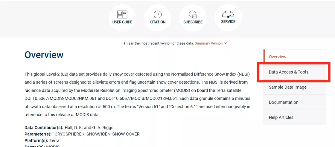
How you access data on NSIDC depends on what you’re interested in. The available options are listed under 'Data Access & Tools' on the landing page for each data set, but in general:
- All NASA Earth science data can be accessed directly from our HTTPS file system. These data can also be accessed via the Earthdata Search interface or programmatically through our Application Programming Interface (API), and for many of these data sets we offer services to customize the data to your needs.
- NOAA@NSIDC data sets can be accessed through NSIDC's HTTPS file system.
- ELOKA data sets are available from the ELOKA website
To determine your access options, first navigate to your data set landing page of interest. All related data access options will be listed on the page along with any featured data tools. You will also see if a free NASA Earthdata Login is required to access the data. We recommend registering with NASA Earthdata to gain the greatest amount of access to data on NSIDC.
Data set landing page features
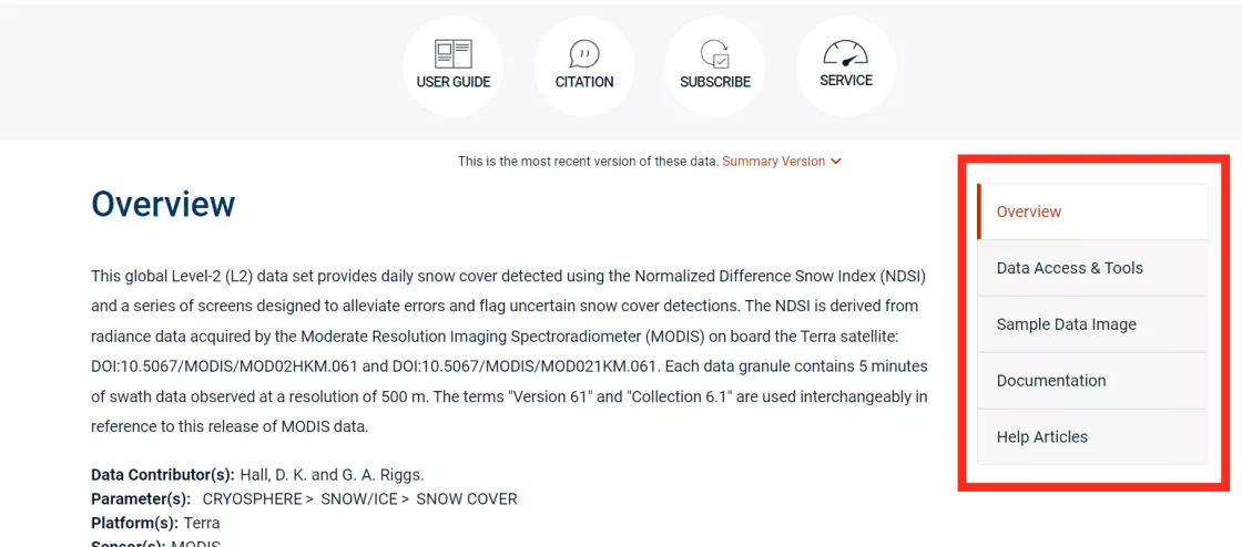
When you click on the name of a data set on NSIDC.org, you’ll be taken to a standard formatted-page called a data set landing page. (example: a MODIS data set landing page)
At the top of each data set landing page there are several icons to quickly access the citation, user guide (if it exists), and level of service to expect for a data set. If a data set has a subscribe icon, you can click it and enter your email address to receive new data release updates for that particular data set.
The data set landing page contains several sections, which can be navigated to via a convenient sidebar menu:
- Overview: A brief summary of the data set and what it contains, including parameters, resolution, and other metadata.
- Data Access & Tools: Contains options for accessing the data, as well as tools to work with the data.
- Documentation: Links to user guides and technical reference documentation to better understand how the data were produced and processed.
- Help Articles: These articles contain step-by-step instructions on how to filter, access, read, customize and convert the data, as well as answers to some common user questions.
Getting data updates
NSIDC shares regular email and web updates about newly published data sets, new versions, temporal updates, and any newly discovered errors or issues. There are several ways to find and receive this information.
- Visit the Data Announcements page to see all updates. You can filter announcements by mission/collection.
- Subscribe for updates about a specific data set. Simply click the Subscribe icon at the top of a data set landing page of interest. Submit your name and email address to receive email updates directly to your inbox for that specific data set. This service is not available for all data sets.
- Visit a data collection announcements page: You can also find data updates related to a specific mission or project by clicking the “Data Announcements” link in the sidebar menu of a data collection landing page. These pages also include an RSS link that you can use to subscribe to announcements.
Types of help resources
Do you have online resources to help me work with NSIDC data?
Absolutely! You can find immediate, any-time assistance with data through our online resources, which include:
Technical Documentation
- User guides are available for most data sets. Click the “User Guide” icon at the top of a data set landing page to open the user guide in your web browser.
- The user guide is also included in a list of all technical documentation lower on the data set landing page.
- Documentation related to a data collection can be accessed from each data collection landing page.
- You can browse our full technical document library here.
Help Articles
- Help articles are organized into an easy-to-browse Help Center.
- You can navigate to any data collection or data set landing Page to browse the articles specific to the data you’re interested in.
Tools and services to access and work with data
- You can navigate to any data collection or data set landing Page to browse the tools and services specific to the data you’re interested in.
- You can also explore our full catalog of featured tools and services here.
Can I get help downloading or working with NSIDC data?
Yes! We have an expert user services support team that is available to help you troubleshoot accessing and working with NSIDC data. Due to the volume of data NSIDC hosts, NSIDC uses a Level of Service model for providing user support and data documentation. At the top of each data set landing page, there is a clickable icon that indicates what level of service NSIDC provides for that data set.
To contact one of our friendly, knowledgeable specialists, just click the “Support” button on any page of the website and submit your question, or send us an email at nsidc@nsidc.org. We’ll get back to you as quickly as possible - typically in less than one (1) business day. Our User Services office is open Monday - Friday, 9 a.m. - 4 p.m. MDT, and closed on most major and federal holidays.
If you are working with NASA data from NSIDC, the NASA Earthdata User Forum is another wonderful community to post questions to and connect with specialists from NASA as well as other data users.
Working with NSIDC data
What technical skills do I need to work with NSIDC data?
That depends on the data set you’re interested in. Our data come in many different file formats. In the NSIDC data search tool, you can filter your data sets by file type. Most data users find they need moderate programming skills and often use Python and R to manipulate the data. Other data can be analyzed in Microsoft Excel, or interpreted using GIS software and Google Earth.
Technical skills needed vary depending on the data set(s) you are interested in and what you want to do with the data. Most of our data are available in a range of commonly used scientific data formats; GeoTIFF, NetCDF-4, HDF, and HDFEOS-5. So, prior experience with one or more of these formats and the software that reads them (e.g., QGIS/ArcMap, Panoply, and HDFView) can be helpful but is not necessary. If you haven’t worked with the data format or software before then the user guide and associated help articles are good resources.
If you wish to download and work with a large volume of data e.g., a large time series, then basic programming skills in languages such as python and R are useful.
We also have some data sets in ASCII format, which are available in text files that can easily be opened in a text editor or a program like Microsoft Excel.
Are there any easy-to-use data for GIS users?
Data in GeoTIFF and/or shapefile format are generally easy to use in GIS software such as QGIS or ArcMap.
You can filter by GIS-friendly GeoTIFF and shapefile format in NSIDC.org’s data search tool. To filter in these formats, select “GeoTIFF” and “Shapefile” under the “Format” menu in the data search tool sidebar.
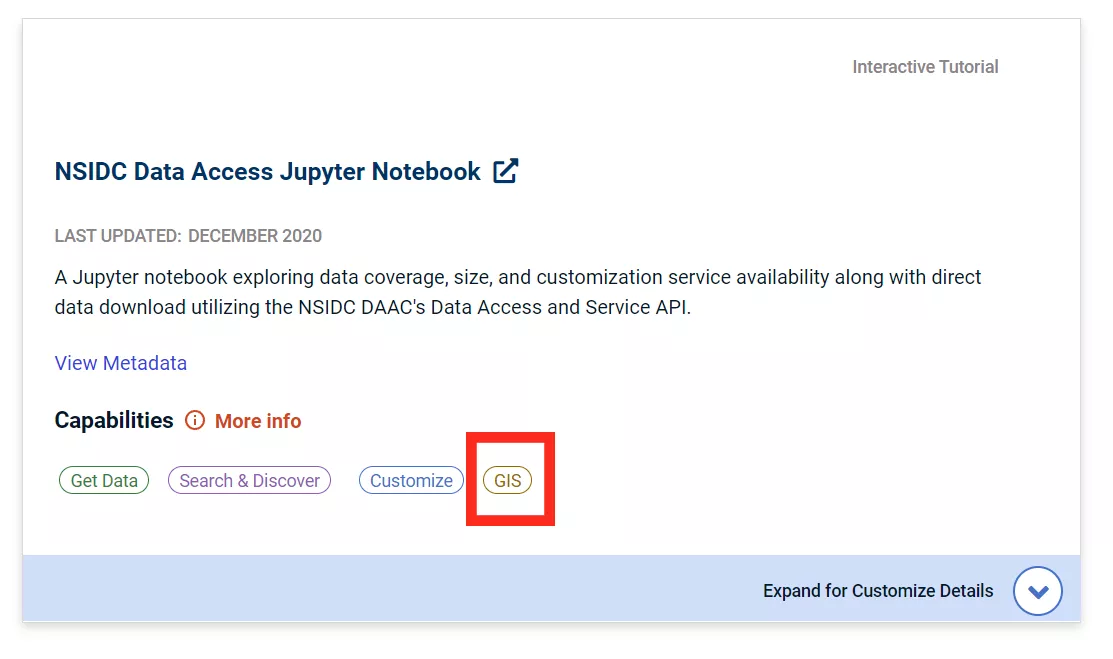
Alternatively, many data sets support additional tools and services that enable usage with GIS-related software or programming packages. To confirm whether such resources are available for a given data set, you can navigate to a data set landing page and click the Data Access & Tools option in the sidebar. If the NSIDC data set contains resources that allow the data to be used in GIS, there will be a GIS icon visible (screenshots below).
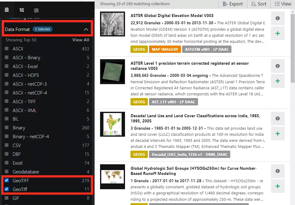
Most NASA mission data can also be filtered in NASA’s Earthdata Search interface to only show GIS-ready GeoTIFF format. Navigate to a data set landing page and click on the NASA Earthdata option under Data Access and Tools. Once you are logged into EarthData Search, under the “Data Format” dropdown in the left sidebar, select “GeoTIFF” and “GeoTiff.” (see screenshot below).
NSIDC also assists with the maintenance of several websites featuring data for GIS users, notably QGreenland, a research project co-led by NSIDC researcher, Twila Moon. This website combines key datasets on Greenland into a unified, all-in-one GIS analysis and visualization environment for offline and online use.
Are there any easy/highly-accessible data sets?
Yes, we do have data sets that are relatively “easy,” as in they do not require any specialized skills or knowledge to access. Below is a list of just a few of our more easily-accessible data sets to get you started:
- The Glacier Photograph Collection is an online searchable collection of photographs of glaciers from around the world. It includes photographs from the mid-1800s to the present day. You can view the photographs online, or you can order a higher resolution copy. There are special collections, including the Repeat Photography of Glaciers which has photographs of the same glacier taken from the same vantage point, same time of year over many different years.
- The Sea Ice Index is a source for consistent, up-to-date sea ice extent and concentration images. There are a couple of tools available for quickly and easily visualizing and comparing these data, Sea Ice Analysis Tool and Sea Ice Spatial Comparison Tool.
- The Multisensor Analyzed Sea Ice Extent - Northern Hemisphere (MASIE-NH) products allow you to view and download Northern Hemisphere-wide sea ice extent since 01 January 2006. The data are available in GeoTIFF and shapefile formats. You can view the extent for 16 Arctic regions and time series plots comparing the data from the past 4 weeks.
Check out our Explore Data page to discover other data sets that may be of interest to you.
I’m interested in data from a specific NASA mission
Start by exploring our list of data collections to find the mission data we manage for that mission.
Resources for educators
Open access data for student projects
Whether you are teaching a graduate level course or an undergraduate level Earth sciences class, NSIDC data can be a wonderful way to incorporate real-world data into your teaching. NSIDC data has even been used by high school students interested in better understanding the cryosphere and how it’s changing.
Here are some resources to get you started:
- For investigating changes in sea ice since 1978 to present, check out the Sea Ice Analysis Data spreadsheets, which are produced from the Sea Ice Index data set. Several spreadsheets are available, including one which has all the daily sea ice extent values from 1978 to present and another which lists the minimum and maximum extent values for each month and year.
- For a visual investigation of how the cryosphere is changing, check out the Repeat Photography of Glaciers special collection in our Glacier Photograph Collection. This special collection displays photographs of the same glacier, taken from the same vantage point and at the same time of year, but taken many years apart. These photographs can show evidence of glacier and climate changes over time.
- Since 1917 the date and time of the break-up of the ice at the same single point on the River Tanana in Alaska has been recorded by the inhabitants of the town of Nenana. The Nenana Ice Classic: Tanana River Ice Annual Breakup Dates data set contains a simple text file that contains all the break-up dates and times, which can be plotted as a time series.
- If you are interested in how SAR data are used to monitor changes in the cryosphere, there is an external Jupyter notebook that walks you through downloading and spatially subsetting glacier velocity data archived at NSIDC. Check this Help article out for more details.
- For a more general overview of changes in the cryosphere, check out the Satellite Observations of Arctic Change page.
There are many more options to use depending on the subjects you are teaching. A great place to start is on our Explore Data and Visualize Data pages.
Data analyses and interactive graphics
Have your class learn about Arctic sea ice and polar ice sheet behavior over time by reading NSIDC scientific analyses and data visualizations.
Educational cryosphere content
In addition to data and scientific analyses, the NSIDC website contains foundational scientific content about what the cryosphere is, and why it matters. Focus sections include sea ice, ice sheets, glaciers, snow, frozen ground and permafrost, Arctic weather and climate, and more.
Data and research stories
Explore the NSIDC news and stories page to read up on how NSIDC data are being used and what the latest research findings are in the realm of cryospheric sciences.
Ongoing scientific research at NSIDC
Explore our featured NSIDC research projects to see if the topics are interesting and relevant to what you are teaching your students. Our research team also includes passionate scientific communicators who are available to answer questions and present on their research.
Other Resources
There are many other resources and tools available to explore the data on NSIDC.org. Have any feedback, or an idea for a tool or feature that would make NSIDC.org even better? Please send it our way at nsidc@nsidc.org.


