By Laura Naranjo
Before the satellite era, remote polar environments made ground- or ship-based research difficult, and sea ice was one of the least understood aspects of Earth’s climate system. Now, sea ice data is literally at our fingertips. The journey to such convenience was not easy.
Beginning in the 1960s, researchers tested satellite and airborne instruments that they hoped could track polar sea ice. Cloud cover and dark polar winters stymied many of these missions, leaving gaps in the data record. In 1972, NASA launched an experimental passive microwave instrument, the Electrically Scanning Microwave Radiometer (ESMR), which operated until 1977. ESMR was a single-frequency instrument that showed potential because it could monitor sea ice in darkness and through clouds, but the resulting data were plagued by technical glitches that were laborious and time-consuming to resolve. As researchers innovated more sensitive instruments, the unsteady trickle of sea ice data soon became a dependable stream.
The dawn of a sea ice time series
On October 25, 1978, the Scanning Multichannel Microwave Radiometer (SMMR) began its mission aboard the Nimbus-7 satellite, launching the modern sea ice satellite record. SMMR was more advanced than ESMR, and used multiple microwave frequencies to more accurately observe concentration, or the percentage of sea ice covering a given area, and extent, or how much of the ocean is covered with at least 15 percent sea ice. In addition, SMMR was capable of distinguishing younger, thinner ice from older, thicker, and more resilient sea ice. In the 1980s, NASA contracted with NSIDC to archive and distribute the resulting sea ice data. This data later became part of the NASA Snow and Ice Distributed Active Archive Center (DAAC) at NSIDC.
As SMMR neared the end of its nine-year lifespan, the US Defense Meteorological Satellite Program (DMSP) began launching a succession of passive microwave sensors, the Special Sensor Microwave Imager (SSM/I) and Special Sensor Microwave Imager and Sounder (SSMIS) instruments. These overlapping missions ensured a continuous record since the launch of SMMR, providing scientists with the first long-term climatology of polar sea ice.
Tracking long-term trends
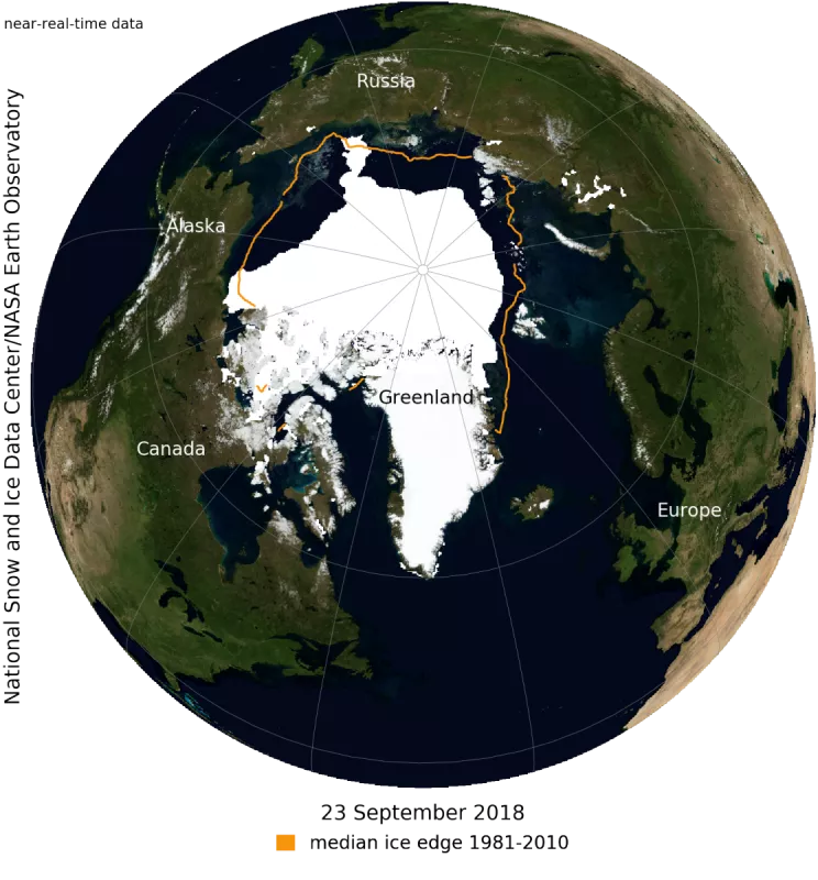
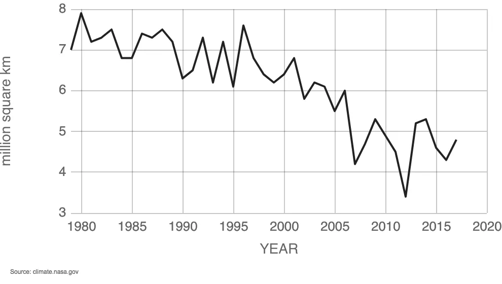
As the time series grew, scientists expected to see the seasonal pulses in polar sea ice: expanding during winter and contracting in summer. They also saw a lot of variability from year to year. “There would be record highs and then record lows,” said Walt Meier, lead scientist for the NSIDC DAAC. “But initially there wasn’t much of a trend. However, by the mid-1990s, a trend in the Arctic sea ice extent was becoming apparent,” Meier said. “Since then, that declining trend has accelerated and is now one of the most iconic indicators of climate change.” In 1979, the minimum Arctic sea ice extent—which occurs in September, after the summer melt season—was 7.0 million square kilometers (2.7 million square miles). By 1995, the minimum dipped to 6.1 million square kilometers (2.4 million square miles), followed by record lows in 2002 and 2007. The current record minimum, set in 2012, is less than half the 1979 minimum. The decline is now 13.2 percent per decade and the twelve lowest minimum extents in the satellite era have all occurred in the last twelve years.
At the other pole, Antarctic sea ice has behaved quite differently, with wild year-to-year variations and very little trend. “Antarctica has become more surprising in recent years by how variable it is,” Meier said. Although Antarctic sea ice extent saw recent record high maximums in 2013 and 2014, they were followed by extremely low maximums in 2017 and 2018 and the two lowest minimums in 2017 and 2018. Yet the satellite record trend indicates a 1.1 percent increase in Antarctic sea ice extent per decade.
Researchers expect the Arctic minimum extent will still vary from year to year, but the satellite record indicates smaller extents and increasingly younger, thinner ice that is more vulnerable to melting. Most of Antarctica’s sea ice melts each summer, meaning age and thickness are not as much of a factor in the analyses and trends, but the satellite record is revealing how wind and ocean currents affect sea ice in the Southern Ocean.
Adding sea ice thickness to the timeline
Although passive microwave data form the backbone of the satellite sea ice record, they only tell part of the sea ice story—how much of the ocean is covered by ice. In addition to extent and concentration, researchers also need data on thickness—the third dimension of sea ice.
In 2003, NASA launched the Ice, Cloud, and land Elevation Satellite (ICESat) mission to track sea ice thickness, as well as ice sheet heights, clouds, and land cover. Shortly before ICESat was decommissioned in 2009, NASA initiated Operation IceBridge to fly similar instruments over the poles aboard aircraft to continue the record until a follow-on mission could be launched. That mission, ICESat-2, launched in September 2018. And just as SMMR marked a significant improvement over earlier sensors, nearly forty years later ICESat-2 technology represents a major advance that will provide a much more detailed and accurate assessment of ice thickness in the years to come.
After forty years, satellite data has made sea ice one of the most studied natural phenomena on Earth. An increasing array of satellite instruments will continue to yield insights about ice conditions, polar climate, and how changes in sea ice affect the rest of Earth’s climate system.
For more information
NSIDC Monthly Highlight: 25 years servicing NASA’s Earth Observing System Data
NSIDC Monthly Highlight: Bridging the gaps
SMMR and SSM/I-SMMIS data at NSIDC


