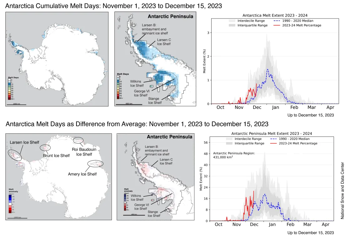
As of December 15, the Antarctic Ice Sheet had above average melt in the Amery and Dronning Maud Land Ice Shelf regions, with significant melting on the Antarctic Peninsula. Greenland’s 2023 melt season was the third highest on record with persistent high melt extents in late June through mid-July, with a late August melt spike.
Current conditions
Antarctic surface melting through December 15 was above average in nearly all the regions with high annual melting totals relative to the 1991 to 2020 reference period. Melt Days were five to eight days above average over the Larsen C and northern George VI Ice Shelves, and a few days above average in the Amery, Roi Baudouin, and Brunt Ice Shelves. While a few melt-related features appeared on landfast sea ice in the Larsen A embayment (not pictured), no melt was apparent on the nearby ice sheet or ice shelf region as of December 15.
Conditions in context
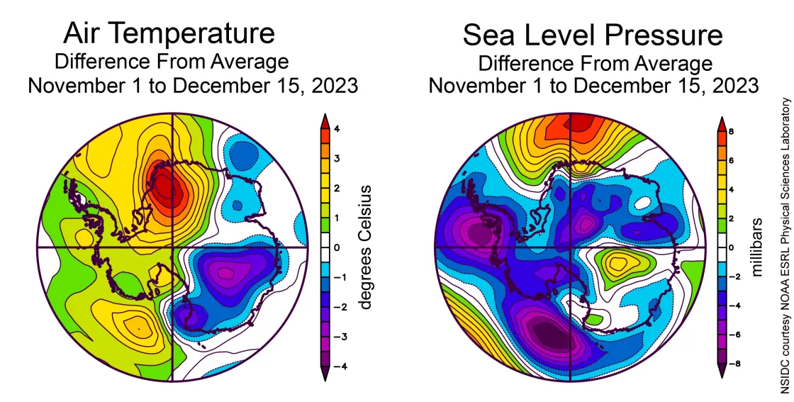
At the start of the melt season, warm conditions prevailed in West Antarctica and the Antarctic Peninsula, with especially warm conditions in western Dronning Maud Land and cooler conditions for much of the rest of East Antarctica. Temperatures in West Antarctica and the Peninsula were 1 to 2 degrees Celsius (2 to 4 degrees Fahrenheit) above the 1981 to 2020 average, and up to 4 degrees Celsius (7 degrees Fahrenheit) above average over western Dronning Maud Land (the Fimbul and Brunt Ice Shelves). Air pressure patterns for the period show a somewhat unusual pattern of two low air pressure centers along the West Antarctic coast, one very near the southwest corner of the Antarctic Peninsula, and one in the western Ross Sea. Counterclockwise airflow from a strong high air pressure area north of Dronning Maud Land drove warm air onto the coast, creating the warmer conditions in that region.
Antarctica’s snow input above average in November
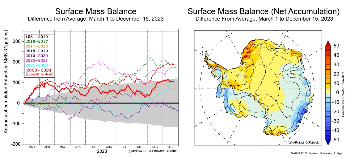
Antarctic climate models, based on weather data and reanalysis of conditions, indicate an above average snowfall in the southeastern Peninsula and in western Queen Maud Land, bringing the snow input total since March 2023 to about 100 billion tons above average (Figure 3). Areas of the western Queen Maud Land coast have up to 50 centimeters (19 inches) more net water input as snow. A more widespread region extending high up onto the East Antarctic Plateau has about 5 centimeters (2 inches) more. However, much of the West Antarctic coastal area facing the Amundsen Sea, from Pine Island Bay to the Getz Ice Shelf, and the Ross Ice Shelf and Siple Coast, had considerably below average snow input.
Greenland's 2023 melt season in review
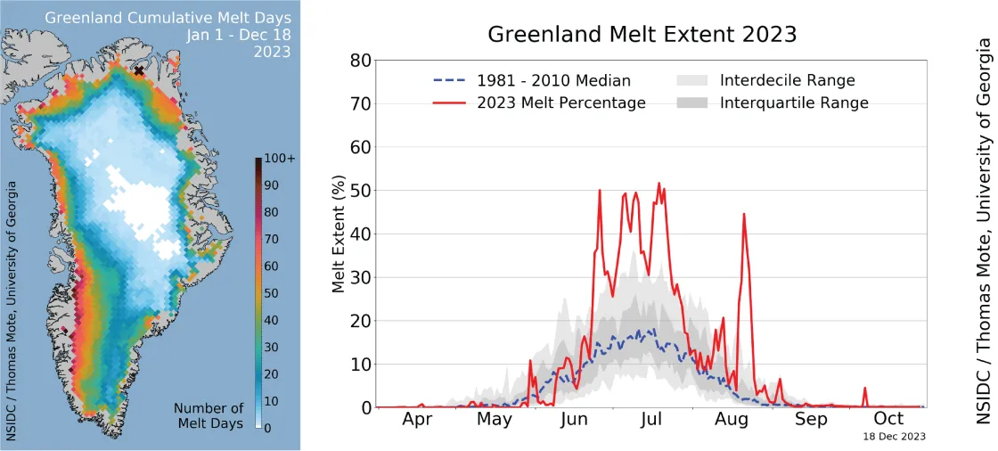
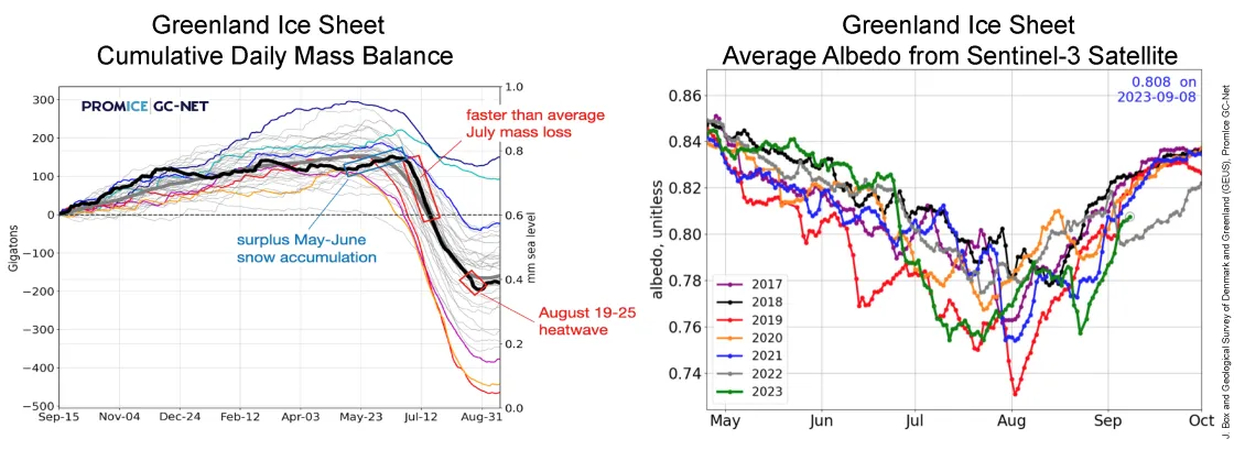
The melt season for the Greenland Ice Sheet was third highest in the 45-year passive microwave record, at 32.9 million square kilometers (12.7 millions square miles), edged out by 2010 at 33.6 million (13 million square miles), and well behind 2012 at 47.4 million square kilometers (18.3 square miles). While slow at the beginning months of April, May, and early June, melt area increased to nearly half the area of the ice sheet by mid-June, and repeatedly reached this level of melt extent over the following four weeks. As noted in our earlier blogs, melting was particularly intense in northern Greenland and along the entire southern peninsula of the island. On August 22, 2023, melt extent reached 750,000 square kilometers (290,000 square miles) in a record-setting melt event on the satellite record for the second half of August, a result of an omega-like pattern of air circulation.
Low snow accumulation in the coastal southern and northern ends of Greenland left older firn and bare ice exposed shortly after significant melting began. This darker surface absorbed more solar energy, accentuating melt. However, total snow accumulation as of May and June was above the long-term average. As the intense melting spread across much of the ice sheet in July, runoff loss increased and eventually exceeded the average annual net mass loss of the Greenland Ice Sheet at season's end.
Reaching and almost reaching the summit
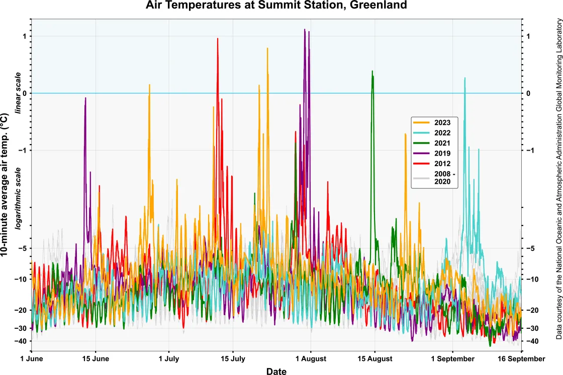
Greenland summer air temperatures have been rising, contributing to one of the most profound changes on the ice sheet—melt occurring at its highest point, Summit Station. On eleven occasions, in five different years (all since 2008 when weather data records began from the National Oceanic and Atmospheric Administration (NOAA) Global Monitory Laboratory), air temperatures at Summit have been within 1 degree Celsius (2 degrees Fahrenheit) of the melting point. On at least six occasions, temperatures have exceeded the melting point. As we have also noted in past reports, rain has fallen at Summit in 2021 for the first time in recorded history. Prior to 2008, melting at the Summit was extremely rare, occurring just once every century or so.
