Ice Shelves
Science
How do ice shelves form?
Ice shelves form in areas where cold ocean water lies next to a large continental glacier or ice sheet that reaches the sea. Under cooling or cold conditions, the ice that reaches the sea will flow out over the ocean, floating as a thick ice plate on top of it. Often the glacier ice flows outward over the frozen ocean in the form of landfast sea ice, displacing it. Under cooling climate conditions, landfast ice can often remain through the summer, persisting for years or even decades, until the surrounding glaciers slowly push it out of the way, forming a true ice shelf.
Along protected coastlines, the resulting ice shelves can survive for thousands of years, supported by the rock of peninsulas and islands. Ice shelves grow when they gain ice from land and occasionally shrink when icebergs calve off their edges. This give-and-take maintains a kind of dynamic stability if climate conditions are relatively stable.
Together, an ice shelf and the glaciers feeding it can form a stable system, with the forces of outflow and back pressure nearly balanced.
Ice shelves and calving
At their seaward edge, ice shelves periodically calve, or break off, chunks of ice called icebergs—some have been the size of a small US state or European country. On a stable ice shelf, calving is a near-cyclical, repetitive process producing large icebergs every few decades. The icebergs drift generally westward around the continent, and as long as they remain in the cold, near-coastline water, they can survive decades or more. However, they eventually are caught up in north-drifting currents, where they melt and break apart further.
In Greenland, floating ice tongues downstream from large outlet glaciers are broken up by crevasses. Icebergs break off the ice tongues. These smaller, steep-sided icebergs sometimes drift south, reaching North Atlantic shipping lanes. Calving of the large glacier, Jakobshavn, on the east coast of Greenland, is responsible for the majority of icebergs reaching Atlantic shipping and fishing areas off Newfoundland. Jakobshavn likely shed the iceberg responsible for the sinking of the Titanic in 1912. The Petermann Glacier in northwestern Greenland also shed a large ice island in August 2010. These denizens of the ocean are now tracked by the National Ice Center in the United States, along with other organizations.
In recent years, calving of the largest ice tongues in Greenland (in particular, Jakobshavn, Helheim, and Kangerdlugssuaq) has accelerated, probably because of warmer air and ocean temperatures. As the ice tongues have retreated, the reduced back pressure against the glacier has allowed these glaciers to accelerate significantly.
By 2006, the Jakobshavn Glacier had retreated to where its two main tributaries joined, leading to two fast-flowing outlets for its ice where there had previously been just one.
Large tabular iceberg calvings are natural events that occur under stable climatic conditions, so they are not a good indicator of warming or changing climate. However, in some cases, persistent calving of large icebergs is thought to be linked to thinning of the ice shelf, which can result from changes in ocean currents or from reduced snowfall on the tributary glaciers.
What causes an ice shelf to collapse?
Collapse refers to an ice sheet that is in irreversible decline. This differs from an ice shelf in a normal process of retreat, such as through iceberg calving. All ice shelves calve bergs and stable ice shelves simply grow back.
Scientists think the increase in ice shelf collapses in both the Arctic and Antarctica are related to climate change. Most of the rapidly retreating ice shelves in Antarctica are located on the Antarctic Peninsula. The Antarctic Peninsula juts north towards South America into warmer waters. The peninsula has warmed 3 degrees Celsius (5.4 degrees Fahrenheit) since 1950, making it one of the fastest-warming places on Earth.
Scientists attributed rapid ice shelf collapse to warmer air and water temperatures, as well as increased melt on the ice shelf surface. Retreating sea ice may also play a role.
Warm air melts the ice shelf surface, forming ponds of meltwater. As the water trickles down through small cracks in the ice shelf, it deepens, erodes, and expands those cracks. In a separate process, warmer water melts the ice shelf from below, thinning it and making it more vulnerable to cracking. Scientists have observed both processes in all the ice shelves that have rapidly retreated in recent years.
However, high temperatures alone do not fully explain rapid ice shelf collapse. Recent research suggests that waning sea ice surrounding the Antarctic Peninsula and the Arctic ice shelves in Canada might also have contributed to the recent collapses. Sea ice provides a layer of protection between an ice shelf and the surrounding ocean, muting the power of large waves and storms. As sea ice decreases, more waves buffet the ice shelves. The largest waves can buckle and bend an ice shelf, increasing instability and possibly contributing to a collapse.
What causes disintegration of an ice shelf?
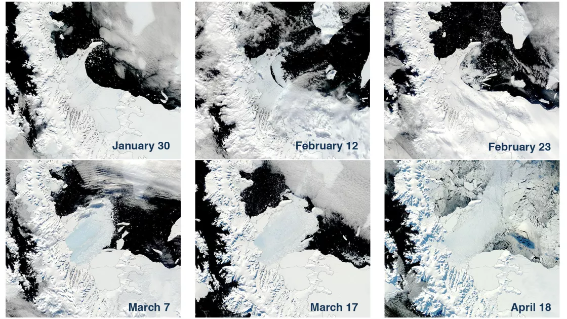
Disintegration of an ice shelf is a specific term for the water-induced, extremely rapid calving process. This process was evident on both Larsen A and B, and a few times on the Wilkins Ice Shelf. There have also been instances where icebergs, drifting on the ocean, have accumulated enough melt on their surface to undergo a disintegration very similar to the Larsen B event of 2002.
Melt ponds and hydrofractures
Building on research from the 1970s and 1980s about Antarctic ice shelf disintegration, researchers developed a theory to explain the process. The theory correlated surface melting and melt pond formation with the potential for rapid calving of icebergs.
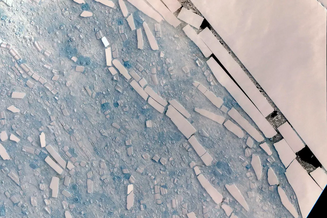
In the case of the Larsen Ice Shelf, as temperatures increased in areas of retreat, melt ponds formed on the surface. In some areas, ice broke off in long, slender icebergs. Sometimes, rapid successive calving took place, and when the icebergs were narrow enough, they toppled over.
These observations led to a model where water from the melt ponds filled surface fractures on the ice shelf. Depending on the amount of water and the depth of a crack, the weight of the water could deepen a fracture and eventually wedge through the ice shelf. This process known as hydrofracture had been described for glaciers many years before. However, abundant surface melt ponds on ice shelves could lead to a rapid runaway event, resulting in the disintegration of large areas in just a few weeks.
The formation of melt ponds depends most upon summer temperatures. Although a single warm summer cannot lead to collapse, a series of warm summers transforms permeable snow into impermeable ice, allowing melt ponds to form during subsequent warm summers. The same process occurs on glaciers in warm climates, with the effect not of disintegrating the ice shelf, but of accelerating the glacier as the water reaches the bedrock.
Sea ice decline
In 2018, a group of researchers examined breakups of the Larsen A, Larsen B, and Wilkins Ice Shelves and found that regional sea ice retreat plays a previously underappreciated role in ice shelf disintegration. Sea ice normally buffers ice shelves from ocean swells. When sea ice retreats, in the wake of higher air temperatures, offshore storm events can send long-period waves toward the front of an ice shelf. If the ice shelf is already flooded and experiencing fracturing along its outer margin, the ocean swells can further weaken the shelf, leading to breakup events.
Warmer ocean temperatures
Warmer ocean temperatures also drive ice shelf breakup. Several studies have cited evidence for warm ocean waters thinning ice shelves from beneath. This “basal melting” appears to be associated with increased rifting and calving of large iceberg chunks (much larger than in the disintegration case). Ocean water just a degree or two above freezing carries huge potential for melting ice. In 2002, a study estimated that for each 0.1°C above freezing point, ocean water circulating under the shelf could melt 10 meters (33 feet) of ice per year. While ocean water in the Antarctic and Arctic is warming slowly, a more important effect appears to be more frequent circulation of warm waters in ice shelf areas caused by wind and current changes.
A 2016 study on Antarctica's past and future sea-level rise examined the interaction between warm ocean water, ice shelves, and the ice sheets they buttress. The study examined the processes of marine ice sheet instability and marine ice cliff instability. Both processes can lead to ice shelf retreat and increased ice flow into the ocean. Where an Antarctic ice shelf retreats to a grounding line deeper than roughly 800 meters (2,600 feet), the ice cliff may protrude above the water line more than 90 meters (295 feet), and such a tall cliff face would be prone to rapid collapse.
Other mechanisms may be operating in areas with warm water circulation that lead to a more gradual destabilization of the ice shelves. Warm water circulating under the shelf and melting the base of the ice shelf produces a return flow that moves back towards the ocean on the underside of the ice. This water, which still has some heat in it, can channelize the underside of the ice, creating inverted canyons in the ice shelf that can focus shear strain and weaken it.
Glacial response to ice shelf collapse
A critical feature of a glacier-ice shelf system is the grounding line, the point where the flowing ice begins to float. If the ice shelf calves and retreats to the grounding line, the glacier is called a tidewater glacier. Tidewater glaciers have no floating section, but the glacier front extends well below the water surface. With further retreat, the tidewater ice front can become taller, protruding higher above the water line. The ocean water exerts less buoyant pressure on the ice, and the loss of the shelf ice removes all back stress from ice rises, or from marginal shear areas. As a result, the flow of the glacier meets very little resistance. In the 18 months following the Larsen B Ice Shelf disintegration in 2002, glaciers feeding that ice shelf accelerated between three and eight times their original speed. Retreat of the Larsen A Ice Shelf led to a two- to three-fold increase in flow of its largest glacier.
Studies published a decade or more after the Larsen B breakup event continued to report accelerated flow in glaciers on the Antarctic Peninsula.
Similar glacier-accelerating mechanisms are at work in the Jakobshavn Isbrae, Kangerdlugssuaq, and Helheim Glaciers in Greenland. Basal melting, or the undercutting of warm ocean waters under the ice shelf near the grounding line, can also accelerate the glacier. Such thinning has been observed in Pine Island Bay, where Thwaites and Pine Island Glaciers feed into. Since at least the 1990s, the basin of Thwaites Glacier has significantly shifted out of balance and its grounding line is retreating. Likewise, the flow of Pine Island Glacier as well as many other glaciers in the area have accelerated.
Examples of ice shelf collapse
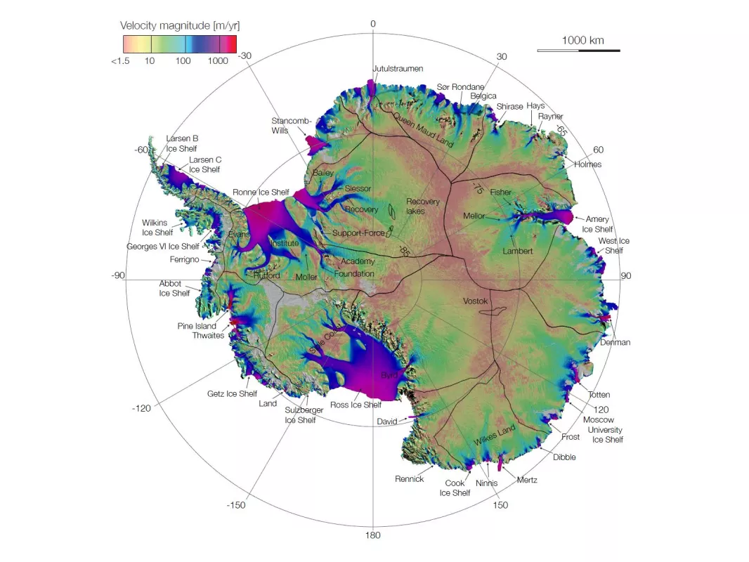
The most pronounced ice shelf retreat occurred on the Larsen Ice Shelf, located on the eastern side of the Antarctic Peninsula's northern tip. From north to south, the ice shelf is divided into multiple regions from A to G.
In January 1995, after several decades of warming and years of gradual retreat, the Larsen A Ice Shelf underwent a type of retreat that had not been witnessed before. The breakup pattern in the Larsen A, in which roughly 1,500 square kilometers (580 square miles) suddenly disintegrated rapidly into small sliver-shaped icebergs, appeared to indicate a new style of ice shelf response to pronounced climate warming. To the south, a 70- by 25-kilometer (43- by 16-mile) iceberg calved from Larsen B. This ordinary calving event received more public attention, but the disintegration event was more significant to researchers studying the area.
Also, on the Antarctic Peninsula, southwest of the Larsen Ice Shelf, lies the Wilkins Ice Shelf. In 1998, the northern part of that ice shelf broke up, although the ice fragments remained in place for the next decade. In 2008, three significant breakups occurred. The first breakup began in late February 2008, on the western part of the shelf, between Charcot and Latady Islands. This breakup style was very similar to the event previously seen on the Larsen A and B. The event occurred during the Southern Hemisphere summer, after an extensive melt season, although no melt ponds were observed. Beginning in May 2008, the western part of the shelf underwent further retreat, again in the disintegration style, despite cold autumn surface conditions. Later in June and July, a substantial portion of the northern part of the shelf also broke up. The breakups occurring between May and July 2008 were especially significant because they happened during the Southern Hemisphere's cold season.
The Wilkins Ice Shelf had broken up in 1998, but the ice blocks remained frozen in place for a decade, held together partly by the accumulation of snowfall. But in 2008, radar images showed a darkening in the areas between ice blocks, followed by the gradual disappearance of these snowy, icy areas. The 2008 imagery indicated thinning between ice blocks, despite winter conditions, and suggested melting from beneath, caused by warm water under the ice shelf. As a result of ice loss to the north, rifts south of the 1998 breakup area began to widen, leading to a series of rapid moderate to large iceberg calvings. Through late winter of 2008, the remaining two-thirds of the shelf stabilized between Latady and Alexander Islands, although fresh cracks appeared on the shelf in late November 2008. In April 2009, the ice bridge connecting the remnant shelf to ice fragments around Charcot Island gave way.
Although smaller than Antarctic ice shelves, ice shelves in the Northern Hemisphere have also attracted the attention of glaciologists. In the early twentieth century, Arctic explorer Robert Peary observed a massive “glacial fringe” along the northern coast of Canada's Ellesmere Island. At that time, this glacial fringe was likely a continuous ice shelf covering some 9,000 square kilometers (3,500 square miles). By the 1950s, much of the ice had disintegrated, and by the turn of the twenty-first century, the once-continuous ice shelf had been reduced to several smaller ice shelves. In 2002, one of those shelves, the Ward Hunt, fractured, releasing several large ice fragments totaling nearly 3 gigatons of ice into the Arctic Ocean. In 2005, another shelf, the Ayles, broke free. In the Northern Hemisphere summer of 2008, a new wave of ice shelf disintegrations began along the Ellesmere Coast, stripping more ice from the Ward Hunt and the Serson, and completely removing the Markham Ice Shelf. The Ward Hunt experienced further fracturing in August 2010, when a Bermuda-sized ice island broke free.
