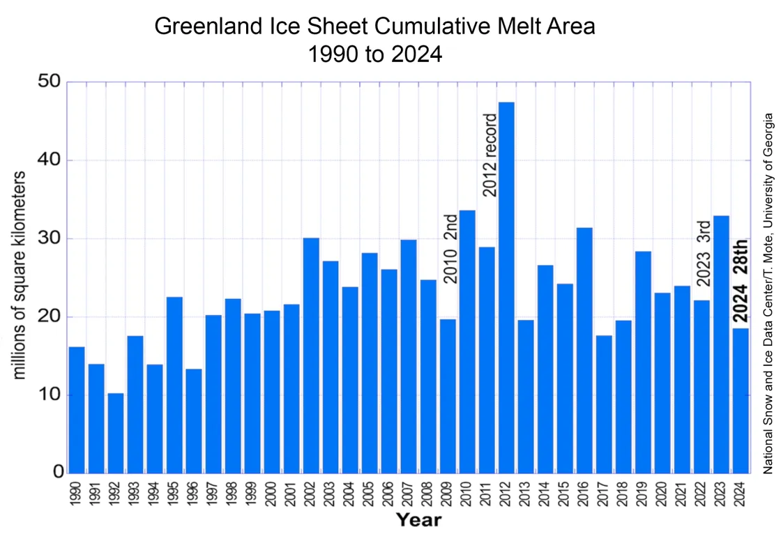
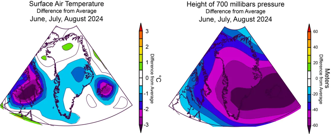
The 2024 melt season for the Greenland Ice Sheet ended with the second-lowest cumulative daily melt extent in this century, ranking twenty-eighth in the satellite record, which began in 1979. Summer air temperatures were generally low over the southern half of the island, with a persistent low-pressure system over Iceland driving cool northern winds across the ice sheet. A late summer heat wave along the northwestern ice sheet closed out the season. Meanwhile in the Southern Hemisphere, monitoring of Antarctica’s melt extent has begun, but daily maps are unavailable at this time. Updates will be provided as the season unfolds.
Overview of conditions
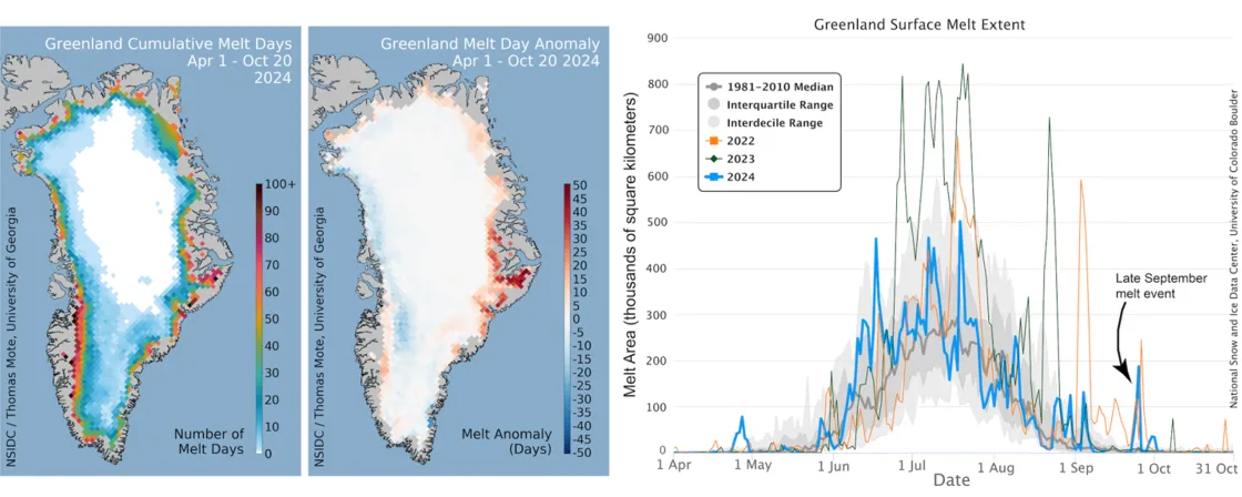
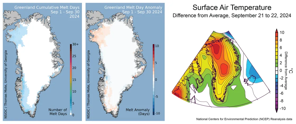
Greenland’s summer melt season featured many low daily melt extents (Figure 1a). The number of melt days was well below average along much of the western side of the ice sheet, by up to 15 days, but above average in the east-central region (up to 40 days above average near Kangertittivaq or Scoresby Sund in east Greenland). No melt occurred in the higher elevations of northern Greenland (above 2,500 meters or 8,200 feet) as has happened in several recent years. Overall, the melt extent for 2024 was the second lowest since 2000 with only 2017 having a lower melt extent (Figure 1b). Since the satellite record began in 1979, the 2024 melt extent ranks twenty-eighth lowest. Persistently snowy conditions through the summer inhibited melt and runoff by maintaining a high reflectivity (high albedo) over the ice sheet, despite the brief clearing of the snow during an intense melt period in late July. Also of note was an early melt event, peaking on June 16, the third highest extent for the date in the satellite record.
Conditions in context
Much of the Greenland Ice Sheet was cooler than average over the main summer months of June, July, and August (Figure 2a). Despite the above average number of melt days across the east-central ice sheet, overall conditions were 1 to 1.5 degrees Celsius (2 to 3 degrees Fahrenheit) below average, and 0.5 to 1.0 degrees Celsius (1 to 2 degrees Fahrenheit) below average for the three-month period prevailed over the southern part of the ice sheet. To the north, conditions were near-average to slightly above average by about 0.5 degree Celsius (1 degree Fahrenheit).
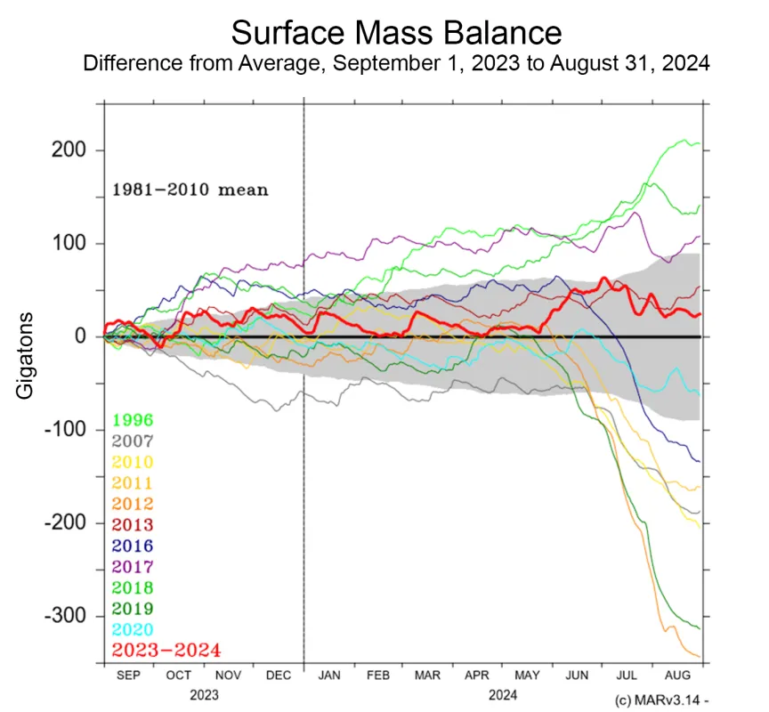
The surface mass balance (SMB), or the total amount of snow and rain minus evaporation and meltwater runoff, remained above average for the entire summer, owing to frequent snowfalls through the season (Figure 2b). Greenland ended the 2023 to 2024 water cycle, which is calculated from September 2023 to August 2024, with a net increase in surface mass. Ice Sheets Today calculates the annual cycle from November to October to capture late-season events, which generally do not lead to runoff. However, faster glacier flow—a consistent feature of the ice sheet since the early 2000’s—will lead to a net loss of ice for the year. So far in the 2024 to 2025 water cycle, which is calculated from November 2024 to October 2025, Greenland’s net snowfall is near average.
September’s last surge
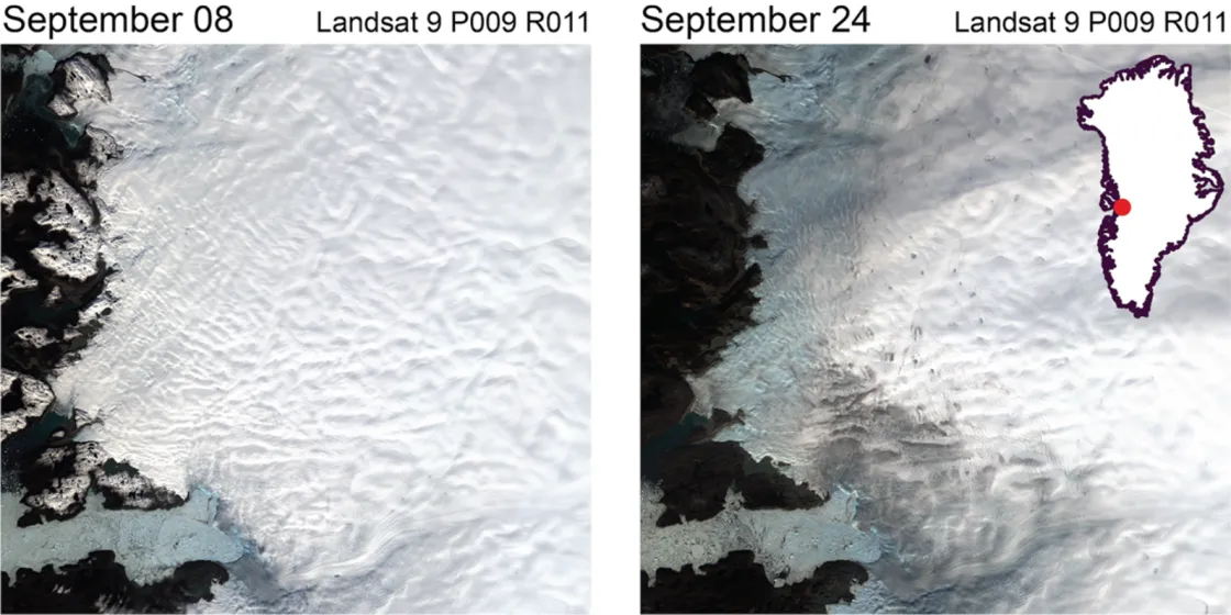
September was a partial exception to the generally cool summer for Greenland in 2024, and a moderate spike in melt extent beginning on September 21 ended the season dramatically (Figure 1a, right). An intense high-pressure system in southern Baffin Bay drove warm air from central Canada onto the northwestern part of the ice sheet, causing extensive melting very late in the season. Temperatures soared to more than 10 degrees Celsius (18 degrees Fahrenheit) above average as the event began, and air temperatures in the following three days were as much as 18 degrees Celsius (32 degrees Fahrenheit) above average over the highest parts of the ice sheet. Still, temperatures did not reach the melting point at that altitude because of the lateness of the event and the onset of autumn. While the event was an extreme surge in temperature, snow and rain precipitation associated with the influx of warm and wet air mass suppressed the impact on SMB as a large part of meltwater was absorbed by snow and snowfall accumulation was larger than meltwater runoff during this event.
