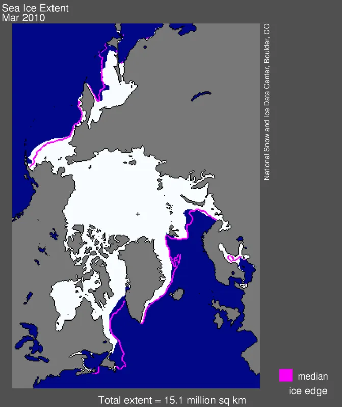
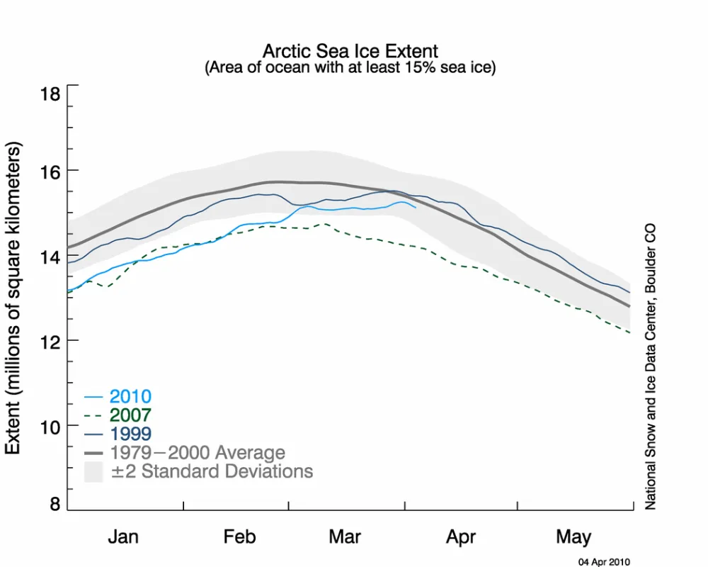
Arctic sea ice reached its maximum extent for the year on March 31 at 15.25 million square kilometers (5.89 million square miles). This was the latest date for the maximum Arctic sea ice extent since the start of the satellite record in 1979.
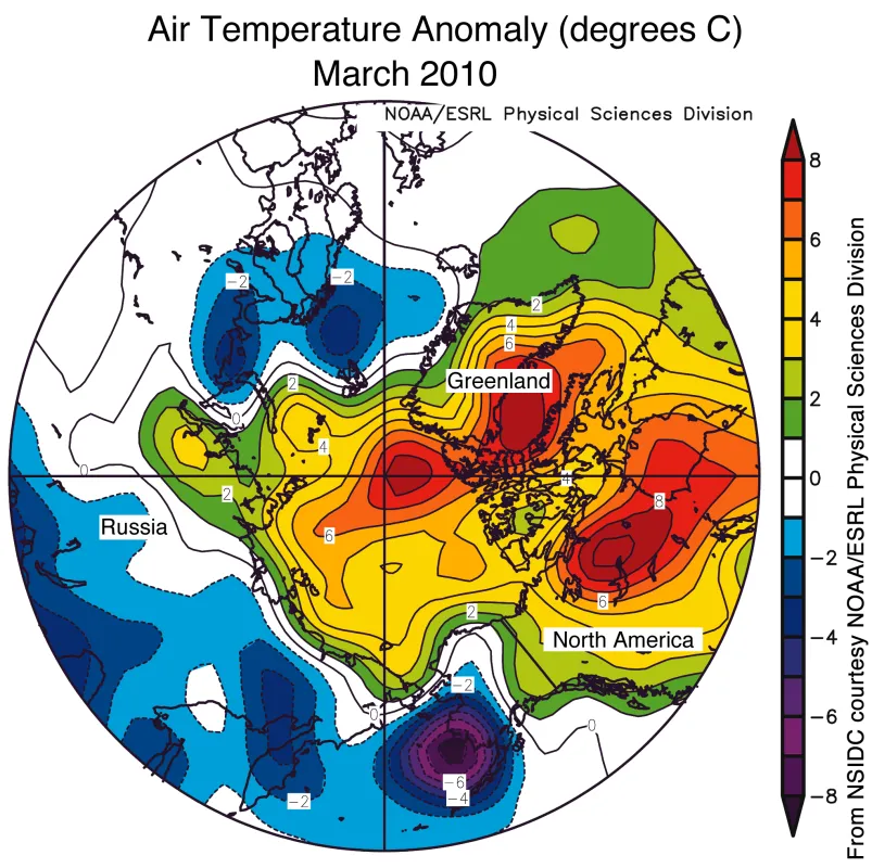
Early in March, Arctic sea ice appeared to reach a maximum extent. However, after a short decline, the ice continued to grow. By the end of March, total extent approached 1979 to 2000 average levels for this time of year. The late-season growth was driven mainly by cold weather and winds from the north over the Bering and Barents Seas. Meanwhile, temperatures over the central Arctic Ocean remained above normal and the winter ice cover remained young and thin compared to earlier years.
Overview of conditions
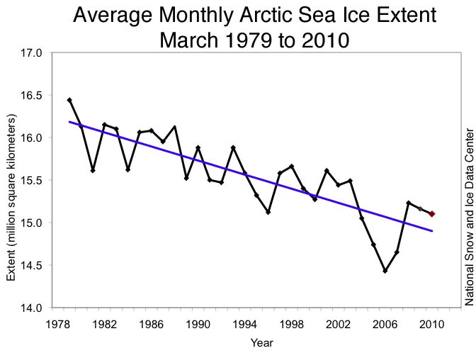
Arctic sea ice extent averaged for March 2010 was 15.10 million square kilometers (5.83 million square miles). This was 650,000 square kilometers (250,000 square miles) below the 1979 to 2000 average for March, but 670,000 square kilometers (260,000 square miles) above the record low for the month, which occurred in March 2006.
Ice extent was above normal in the Bering Sea and Baltic Sea, but remained below normal over much of the Atlantic sector of the Arctic, including the Baffin Bay, and the Canadian Maritime Provinces seaboard. Extent in other regions was near average.
Conditions in context
Sea ice reached its maximum extent for the year on March 31, the latest maximum date in the satellite record. The previous latest date was on March 29, 1999. The maximum extent was 15.25 million square kilometers (5.89 million square miles). This was 670,000 square kilometers (260,000 square miles) above the record low maximum extent, which occurred in 2006.
Sea ice extent seemed to reach a maximum during the early part of the month, but after a brief decline, ice extent increased slowly and steadily through the end of the month. By the end of the month, extent had approached the 1979 to 2000 average. During March 2010, ice extent grew at an average of 13,200 square kilometers (5100 square miles) per day. Usually there is a net loss of ice through the month.
March 2010 compared to past years
The average ice extent for March 2010 was 670,000 square kilometers (260,000 square miles) higher than the record low for March, observed in 2006. The linear rate of decline for March over the 1978 to 2010 period is 2.6% per decade.
Late-season growth spurt
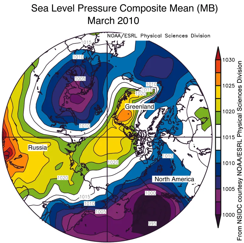
The maximum Arctic sea ice extent may occur as early as mid-February to as late as the last week of March. As sea ice extent approaches the seasonal maximum, extent can vary quite a bit from day to day because the thin, new ice at the edge of the pack is sensitive to local wind and temperature patterns. This March, low atmospheric pressure systems persisted over the Gulf of Alaska and north of Scandinavia. These pressure patterns led to unusually cold conditions and persistent northerly winds in the Bering and Barents Seas, which pushed the ice edge southward in these two regions.
Meanwhile, elsewhere in the Arctic
This winter’s strong negative mode of the Arctic Oscillation was moderated through the month of March. Average air temperatures for the month nevertheless remained above average over the Arctic Ocean region. Overall for the winter, temperatures over most of the Arctic were above average, while northern Europe and Siberia were colder than usual.
Ice age and thickness
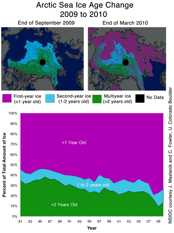
The late date of the maximum extent, though of special interest this year, is unlikely to have an impact on summer ice extent. The ice that formed late in the season is thin, and will melt quickly when temperatures rise.
Scientists often use ice age data as a way to infer ice thickness—one of the most important factors influencing end-of-summer ice extent. Although the Arctic has much less thick, multiyear ice than it did during the 1980s and 1990s, this winter has seen some replenishment: the Arctic lost less ice the past two summers compared to 2007, and the strong negative Arctic Oscillation this winter prevented as much ice from moving out of the Arctic. The larger amount of multiyear ice could help more ice to survive the summer melt season. However, this replenishment consists primarily of younger, two- to three-year-old multiyear ice; the oldest, and thickest multiyear ice has continued to decline. Although thickness plays an important role in ice melt, summer ice conditions will also depend strongly on weather patterns through the melt season.
At the moment there are no Arctic-wide satellite measurements of ice thickness, because of the end of the NASA Ice, Cloud, and Land Elevation Satellite (ICESat) mission last October. NASA has mounted an airborne sensor campaign called IceBridge to fill this observational gap.
