By Agnieszka Gautier
On the world’s most massive ice sheet, the bitter wind sculpts the surface snow into long, low dunes that are barely detectable while staring out into the horizon. Between the dunes, katabatic winds, caused by dense, cold air sinking and flowing off the continent, polish wind-swept areas to a high glaze. Much like waves on the ocean, megadunes form against the wind with scavenged snow rising only a few meters high but running tens of miles long and up to two miles wide.
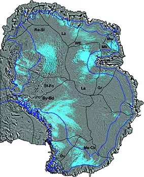
NSIDC lead scientist Ted Scambos has studied these formations for more than a decade. “Wind-glaze regions represent near-permanent bare patches in the snow layer—instead of a blanket layer, it’s more like Swiss cheese,” Scambos said. “Count the holes in the Swiss cheese and the overall accumulation of snow is much less than most modern scientists are saying.” Knowledge of Antarctica’s snow precipitation informs its contribution to seal level and is measured by the surface mass balance (SMB), or the difference between accumulation and ablation (sublimation and melting). A negative SMB implies a retreating ice sheet. So Scambos, along with a team of scientists from around the world, used a combination of satellite remote sensing and field-gathered datasets to map the extent of wind glaze in the East Antarctic Ice Sheet (EAIS) plateau.
Formation of wind glaze
The EAIS, much bigger than its western-hemisphere counterpart, features a distinctive topography of megadunes and wind-glaze surfaces, sculpted by the intense climate of the region. Low temperatures and low snow-accumulation, coupled with near-continuous katabatic winds, create wind-glazed surfaces that can be 2 to 200 square kilometers (1 to 77 square miles) in area, usually above 1,500 meters (4,920 feet) on the leeward slopes of megadunes.
The wind-glaze surfaces result from strong winds, driven by the continent’s temperature inversions. Typically the air closer to the Earth is warmer because the sun radiates warmth off the Earth’s surface. Due to Antarctica’s thick ice sheet, with an average thickness of 2,012 meters (6,600 feet), the coldest, most dense air hovers on the surface, providing the impetus for Antarctica’s notoriously strong winds that sweep out toward its coastlines. With higher elevations, the gravity-driven drainage of cold inversion air accelerates the flow, removing any precipitated or wind-deposited snow within wind-glaze regions.
Wind gives a snowstorm personality. Under seemingly choreographed gusts, snow appears to merely resettle. Prior studies have assumed the same: wind distribution of snow is a mass-conservative process, meaning that mass lost from windswept areas is deposited in adjacent areas. But on the EAIS plateau, adjacent high-accumulation regions do not compensate for the surface loss. Since air must compress to descend, the snow it carries down a mountainside gets progressively drier, smaller in particle size and more dissolvable.
An in-depth look
Beneath wind-glaze surfaces, a porous firn layer, 50 to 70 meters (164 to 230 feet) thick, preserves old snow with unique characteristics. Solar energy transmits more heat through a polished surface than an unmodified snow surface, warming the underlying firn and driving water vapor up. Condensation follows. Decades to centuries of repeated seasonal cycles have resulted in the formation of fingernail-sized crystals, which have been misrepresented in SMB measurements due to the intensity of their recrystallization.
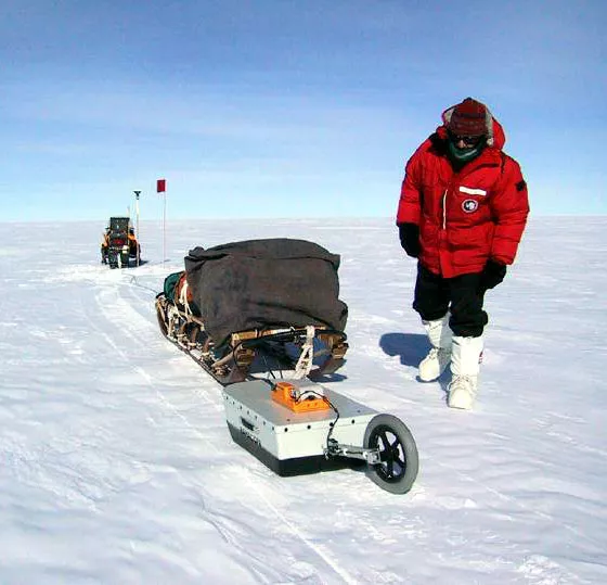
Where other studies have wrongly interpolated field measurements across glaze regions, Scambos and his colleagues used Ground Penetrating Radar (GPR) to properly image the subsurface and determine the extent of wind-glaze regions. Earlier climate models have assumed the scope of wind glaze on the EAIS insignificant, but with about 11 percent identified, the regions can no longer be ignored. Results show that the overall SMB has been exaggerated anywhere between 46 to 82 gigatons, a large fraction to the net imbalance, meaning the actual SMB should be slightly negative. “If accounted for properly, this means there is less snow than we thought before,” Scambos said. “The implication is that Antarctica may be contributing more to sea level rising than we currently think.”
Reference
Scambos, T. A., M. Frezzoti, T. Haran, J. Bohlander, J. T. M. Lenaerts, M. R. Van Den Broeke, K. Jezek, D. Long, S. Urbini, K. Farness, T. Neumann, M. Albert, J.-G. Winther (2012), Extent of low-accumulation 'wind glaze' areas on the East Antarctic plateau: implications for continental ice mass balance, Journal of Glaciology, Vol. 58, No. 210, doi: 10.3189/2012JoG11J232.

