By Jane Beitler
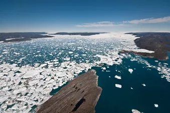
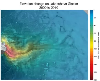
In 2001, Jakobshavn Glacier on the west coast of Greenland was already the fastest-moving glacier on Earth; like the majority of glaciers around the world, Jakobshavn was displaying the effects of climate warming. Since then it has continued to accelerate, and by 2010 it was moving at a pace of fifteen kilometers per year, twice as fast as before.
In fact, preliminary research by Ohio State University glaciologist Ian Howat shows that in the last ten years Jakobshavn Glacier alone has dumped 260 gigatons of ice into the ocean, enough to add one millimeter to sea level rise. Jakobshavn is not the only runaway glacier in Greenland—and together, faster moving glaciers are draining ice from the Greenland Ice Sheet into the ocean, adding to sea level rise.
Birds-eye view
The weight of glacial ice normally causes its icy mass to inch towards the glacier's low end, shedding ice in a natural cycle, but in recent decades the pace has picked up. Behind Greenland's glaciers lies a massive ice sheet, amd this ice too can become ocean-bound when glaciers accelerate. Ben Smith, a glaciologist at the University of Washington, is keeping an eye on Jakobshavn and other fast-moving glaciers in Greenland with remote sensing data from satellites and airplanes.
Those data now include data products from the NASA IceBridge mission, an airborne data-gathering project aimed at bridging the data gap between two Ice, Cloud, and land Elevation Satellite (ICESat) missions. The first ICESat mission ended in 2010, and ICESat-2 will launch in 2015. Smith said, "The ice sheet is not going to stop doing interesting things between the two ICESat missions. Having a picture of how glaciers have changed during that time will be really important."
IceBridge prevents a data gap
Although the IceBridge mission just started a little over a year ago, data are already online at NSIDC for researchers worldwide. The data sets include elevation profiles from the Airborne Topographic Mapper (ATM), similar to the elevation data provided by ICESat, and ice-penetrating radar data which shows the topography of the land beneath the ice sheet. Smith and his colleagues are combining these two data products with elevation data from ICESat and ATM data from pre-IceBridge missions, which NSIDC also distributes.
Smith's preliminary studies with these data show that while Jakobshavn continues to dump ice into the ocean, two other fast-moving glaciers, Kangerdlugssuaq and Helheim on Greenland's east coast, are no longer losing as much ice as they were in 2003 or 2004. While the surface of both glaciers continues to move at about the same speed, the amount of ice flowing into the ocean has slowed as the glaciers thinned. It turns out that glacier flow varies with factors like the topography of land under them and the thickness of the glacier. "This is good news in the short term," Smith said, especially for low-lying coastal dwellers most at risk from sea level rise, because ice may not be flowing into the ocean through these glaciers as fast as data collected in 2004 and 2005 indicated. But he added, "It's hard to say what will happen as the ice fronts retreat further up the fjord." So as Greenland's glaciers continue to flow, Smith and other Arctic glaciologists will be watching, using all the data available to better understand how, why, and how fast the Greenland Ice Sheet is changing.
For more information on IceBridge data available at NSIDC, see the NSIDC IceBridge.

