Sea Ice
Why it Matters
In the Arctic, sea ice is a way of life—from the animals that depend on it for breeding, shelter, and food, to the people who rely on hunting for their livelihoods. How the ice forms in the fall, how thick it is, the location of openings in sea ice, and how it retreats in the spring determine where the animals are and whether it is safe for hunting.
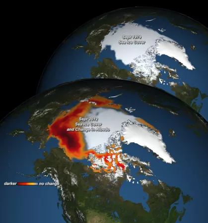
Communities living near sea ice depend on it for their cultural identity and subsistence practices, but its impacts stretch far beyond. Even though sea ice occurs primarily in the polar regions, it influences our global climate. Arctic sea ice acts like the planet’s air conditioner. Its bright, white surface reflects sunlight back into space. In other words, sea ice does not absorb much solar energy, keeping temperatures relatively cool in the Arctic. However, as more sea ice retreats throughout the year, the darker open oceans absorb more solar energy, raising temperatures and setting off a cycle of warming and further melting. Even a small increase in temperature can lead to greater warming over time, making the polar regions the most sensitive areas to climate change on Earth. The Arctic, for instance, is warming at two to three times the rate of the rest of the planet. At the other pole, the Antarctic Peninsula is not far behind in terms of rate of warming.
Sea ice helps regulate exchanges of heat, moisture, and salinity in the polar oceans. It insulates the relatively warm ocean water from the cold polar atmosphere except where cracks, or leads, in the ice allow exchange of heat and water vapor from ocean to atmosphere in winter. The number of leads determines where and how much heat and water are lost to the atmosphere, which may affect local cloud cover and precipitation. As sea ice extent shrinks and breaks up, exposed ocean waters increase. With more moisture forming in the atmosphere, and with higher air temperatures, the question arises: will more rain-on-snow events occur in the Arctic? On land, rain on snow can have catastrophic consequences on livestock unable to penetrate newly-formed thick ice to access food.
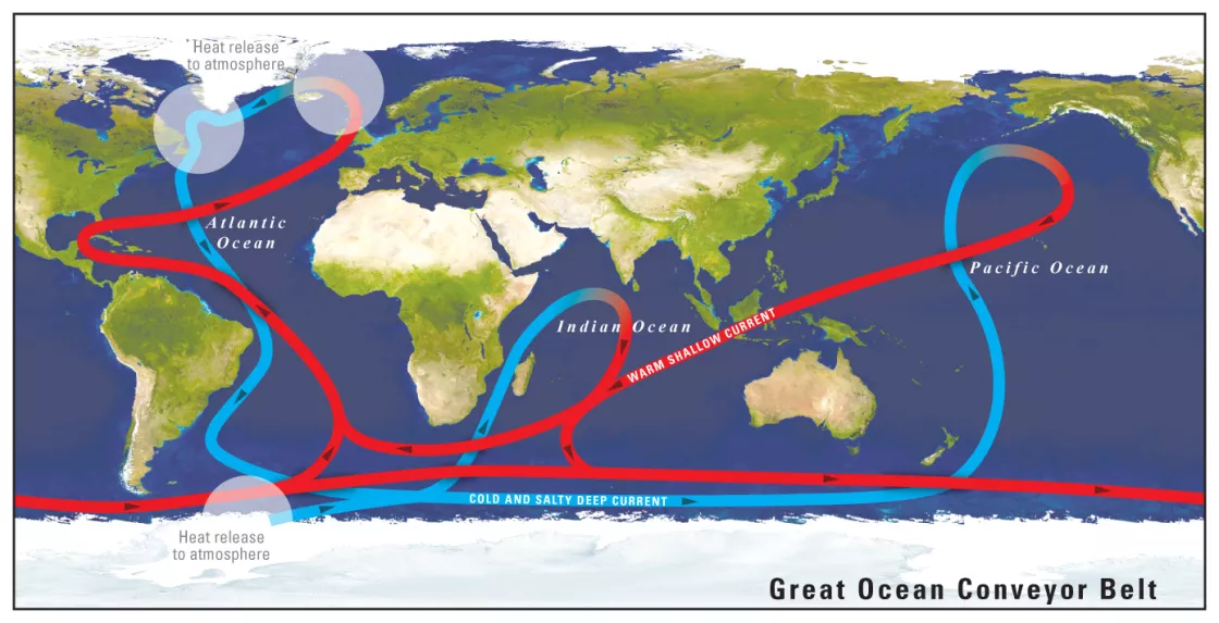
Sea ice can influence ocean currents. When sea ice forms, most of the salt is pushed into the ocean water below the ice. Some salt, however, may linger in small pockets between ice crystals. Water below newly-formed sea ice has a higher concentration of salt, making it more dense than surrounding ocean water. This salty, dense water sinks, flowing along the ocean bottom toward the equator. Meanwhile, warm water from mid-depth to the surface travels from the equator toward the poles. In this way, sea ice contributes to the ocean's global conveyor-belt circulation. Changes in the amount of sea ice can disrupt ocean circulation, thereby leading to changes in global climate.
Sea ice and wildlife
Sea ice provides a resting and birthing place for seals and walrus, a hunting and breeding ground for polar bears, and a foraging ground for arctic fox, whales, caribou, and other mammals. A lack of ice and poor ice conditions cause stress for marine mammals and ultimately affect their livelihoods and abilities to reproduce. According to the Arctic Monitoring and Assessment Programme’s 2017 report, Snow, Water, Ice, Permafrost in the Arctic, expected reductions in sea ice will drastically shrink marine habitats for ice-dependent seals, polar bears, and some seabirds, likely pushing some species to extinction.
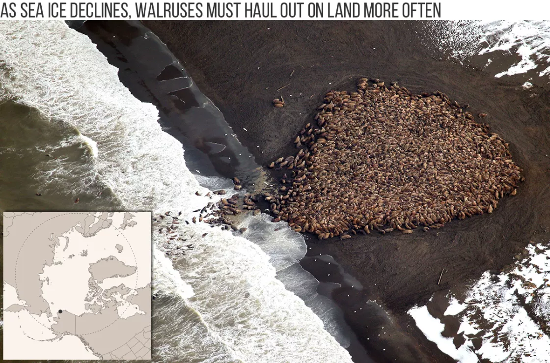
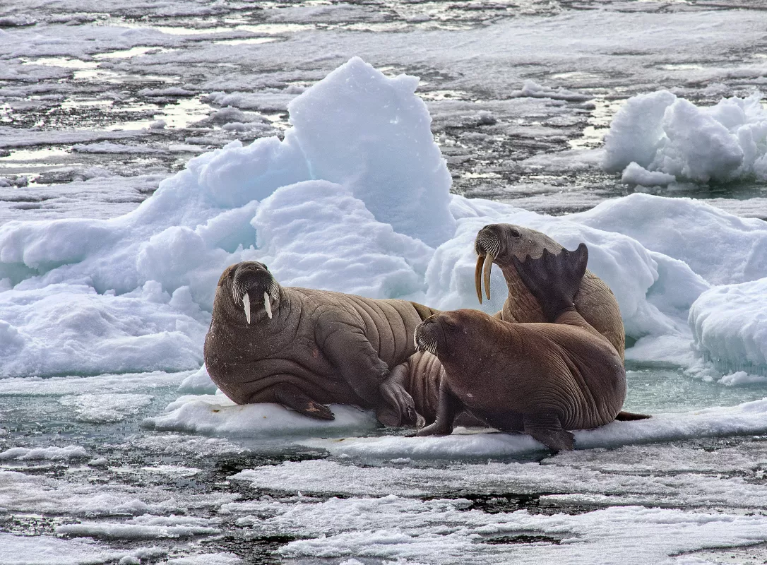
Poor ice conditions affect polar mammals in a variety of ways. If the pack ice retreats beyond the edge of the continental shelf where walrus typically feed, they must swim great distances—up to 402 kilometers (250 miles) round trip—to reach their feeding grounds, or crowd on shores and small islands. With disappearing sea ice, the survival of walruses is becoming a delicate issue. Researchers first observed large hordes of mostly females and calves on shores in 2007, when summer Arctic sea ice reached its second-lowest minimum extent on the satellite record. In 2014, about 35,000 walruses hauled out on a small stretch of beach in Point Lay, Alaska. Such massive gatherings are dangerous. Crowded walruses are easily spooked. Any unfamiliar sound or smell, such as an airplane flying above or a whiff of a polar bear, can cause a deadly stampede such as the one observed in 2017 in Cape Schmidt, Russia, where 500 walruses died following a disturbance.
Other mammals are struggling too. Arctic foxes have been stranded on shore with land predators, instead of being able to migrate onto the ice. Peary caribou have been observed falling through unusually thin ice during their migrations.
Narwhals are a species of whale that migrate closer to coasts in summer. When the winter freeze begins, they move away from the shores and live below densely packed ice, surviving by breathing through leads and small fractures in the ice. As spring comes, these leads open up into channels, and the whales return to coastal bays. Sometimes dubbed the unicorn of the sea, the narwhal’s long tusk, which is actually a tooth, may help them detect temperature, water pressure, particle gradients, and motion. Researchers suggest that because of the sensitivity to salinity concentrations in seawater, the male narwhal tusk may have the ability to read and navigate ice formation in Arctic waters. The whale’s migration and behavior patterns may thus be potential indicators of arctic climate and environmental change.
The foundation of the polar food web: phytoplankton
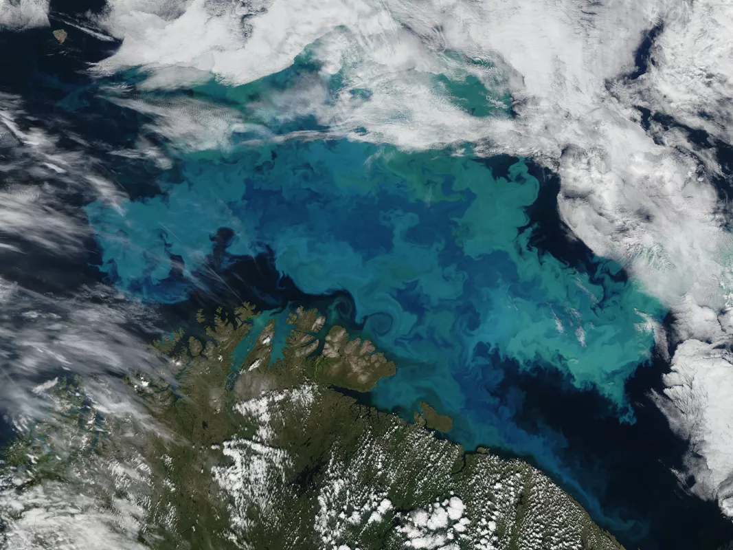
Although conditions are harsh, life thrives above, below, and within sea ice, which in itself is a key component of the food web, sustaining migratory birds, fish, and other species. Sea ice fulfills fundamental functions in the seasonal rhythm of life. Sea ice offers a platform for algae to grow. When sea ice melts in spring, the algae enters the sea and fuels a bloom of tiny marine plants, phytoplankton. Phytoplankton are the foundation of the marine food chain. Fish feed on phytoplankton, shrimp, and other small organisms. In turn, fish feed the seals, which feed the bears and orcas.
Like plants on land, phytoplankton use sunlight and nutrients to produce their own food. Cold, polar water is the perfect breeding ground for phytoplankton.
Each spring, when sea ice melts in the Arctic or Antarctic, the ice leaves behind a layer of freshwater on the ocean surface that is full of nutrients. Though sea ice forms out of salty, ocean water, when it freezes, the process of freezing pushes out its salt. So, when sea ice melts, layers of freshwater float above the heavier, briny waters. Microorganisms use the nutrients in the freshwater to develop, forming the basis of the food chain.
Another source of nutrient-rich water appears when cold, dense polar water sinks to the ocean bottom, forcing deep, nutrient-laden water to the surface. Polynyas also have rich nutrients that support the growth of phytoplankton.
Phytoplankton blooms, rapid reproduction and growth of phytoplankton, occur in the surface water each spring, when sunlight easily penetrates the water and provides energy. The Southern Ocean that surrounds Antarctica is one of the most productive areas on Earth, but only during the Antarctic summer—a few months around December—when abundant sunlight provides the perfect conditions for phytoplankton to multiply in vast quantities.
These blooms feed krill, tiny, shrimp-like animals, which in turn are eaten by Adélie penguins, seabirds, seals, whales, and other animals. Phytoplankton also support the development of different species of fish. The fisheries of the North Pacific Ocean and the Bering Sea are among the most productive in the world, in part because of the large concentration of phytoplankton there.
Conventional wisdom held that phytoplankton blooms could only occur in open water, but in 2012, a NASA-sponsored mission, Impacts of Climate on EcoSystems and Chemistry of the Arctic Pacific Environment (ICESCAPE), discovered a massive bloom in the Chukchi Sea, under a layer of Arctic ice.
In Antarctica, Adélie penguins depend on polynyas, where phytoplankton are abundant, throughout much of their lives. In East Antarctica, more than 90 percent of all Adélie penguin colonies live next to coastal polynyas. The open water provides a concentrated food source for the penguins, who time their cycles with food availability. Adélie penguins have their chicks in the late spring or early summer, so that food is abundant when the chicks need it.
Because phytoplankton are vital to so many different species, scientists monitor the highest concentrations using satellites.
Different types and quantities of phytoplankton show slightly different colors when viewed from space. The more phytoplankton present in the ocean water, the greater the concentration of plant pigments and the greener the water. The Sea-viewing Wide Field-of-View Sensor (SeaWiFS) satellite mission was designed to monitor changes in ocean color as an indicator of primary productivity, the amount of organic material produced by phytoplankton. Visit the OceanColor Web at the NASA Goddard Space Flight Center website.
A closer look: seals
Many different species of seal live in both Antarctica and the Arctic, and life cycles vary considerably among species. Some species depend entirely on the presence of sea ice to survive. Many give birth and nurse their pups on the ice, and they forage for food near the ice edge and under the ice. Most seals never leave the ice pack, creating open breathing holes all winter, and they make lairs under snow mounds to protect newborn pups from polar bears and from the cold air above.
Arctic seals
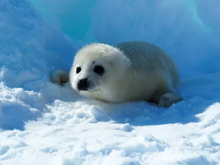
Six seal species live in the Arctic: harp, hooded, ringed, bearded, spotted, and ribbon. Although sea ice affects all these seal species, harp, ringed, and bearded seals have life cycles that are tightly linked to sea ice. Harp seals follow and live at the sea ice edge all year. In the spring, harp seals migrate southward, assembling in large groups to breed near the Newfoundland and Norwegian coasts. During late February and early March, thousands of harp seal females gather to deliver their babies on the White Sea ice.
Ringed and bearded seals often use holes in the ice to breathe, and they congregate along the edges of the ice. Ringed seals use fast ice and sometimes dense pack ice for giving birth. They require sufficient snow cover on the ice to construct birth lairs, and the sea ice must be stable enough in the spring to rear the pups. Some ringed seals in the Okhotsk Sea, north of Japan, regularly give birth on the exposed sea ice surface. Unlike the harp seal, the ringed seal does not migrate to open water in the winter.
Decreasing sea ice extent would reduce the habitat available to ringed seals. Early ice breakup could result in premature separation of mothers and pups, leading to higher death rates among newborn pups. In the southern Baltic Sea, from 1989 to 1995, a series of nearly ice-free winters led to high pup mortality rates. If autumn and winter are fairly mild, the ice is soft and thin and disintegrates easily. As a result, newborn seal pups, which are born on the ice, do not have enough time to wean properly and may not survive. Seal pups need at least 12 days on the ice before they finish nursing.
Across the North Atlantic, sea ice cover in breeding habitats for harp seals has declined since the start of the satellite record. Although harp seal populations can withstand occasional years of poor ice conditions, a long-term decline in ice conditions endangers populations by increasing pup mortality.
Antarctic seals
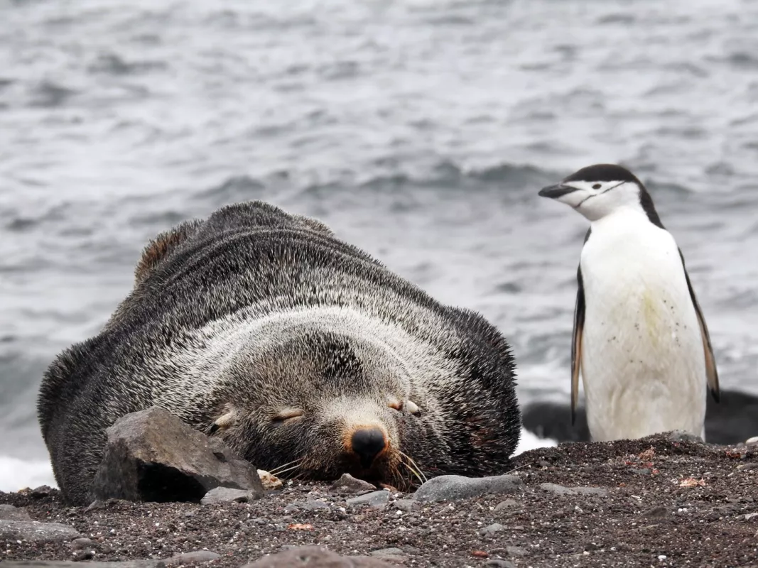
Although only four species of seal are found in Antarctica—crabeater, Weddell, leopard, and Ross—there are many more individual seals in Antarctica than in the Arctic. This is primarily due to the crabeater seal, which far outnumbers any other species; there are more crabeater seals than all other seal species combined. Despite their name, crabeaters subsist almost entirely in krill, and so they are part of the phytoplankton-based Antarctic food chain. Like Arctic seals, crabeater seals depend on pack ice for breeding and giving birth.
Although killer whales, also known as orcas, can pose a threat, the primary predators of crabeater seals are leopard seals. Because of their large size, leopard seals cannot move easily on sea ice, and so crabeater seals often rest on floes where they are safe from predation. Clearly, a decrease in sea ice could negatively affect crabeater seal populations by increasing predation and decreasing breeding and birthing sites.
Sea ice characteristics also affect Weddell seals, the favorite among most Antarctic visitors because of their placid nature. Weddell seals spend most of their time beneath fast ice, coming onto the sea ice surface only to rest and have their pups. Modified physiology allows Weddell seals to spend up to 80 minutes underwater, sufficient time to hunt and search for cracks in the ice that they can use as breathing holes.
A closer look: polar bears
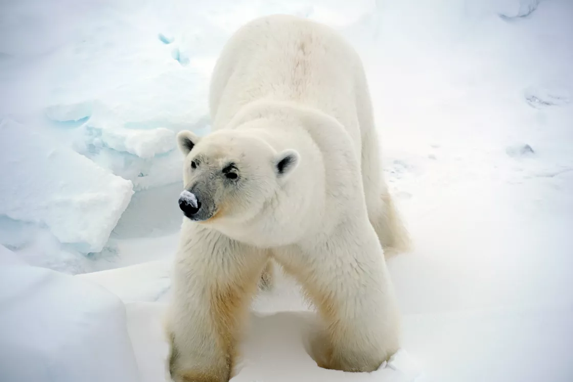
Polar bears are found only in the Arctic, where they are the largest land carnivore and top predator. Polar bears prefer multiyear ice—a thick stable, years-old sea ice—for protective cover and for a platform to hunt their favorite food, ringed and bearded seals. During the summer, they eat very little while they wait for the ocean to freeze. In areas such as eastern Baffin Island and Hudson Bay, where most or all of the pack ice melts by mid- to late summer, the entire bear population must come ashore for two to four months in summer and early fall to wait for the ice to freeze again, the World Wildlife Fund reports.
Although polar bears are considered capable swimmers, they have not often been observed swimming far from land. A 2006 study in Polar Biology concluded that poor sea ice cover in the Arctic may contribute to increased polar bear mortality by forcing the animals to swim excessive distances between land and the pack ice edge.
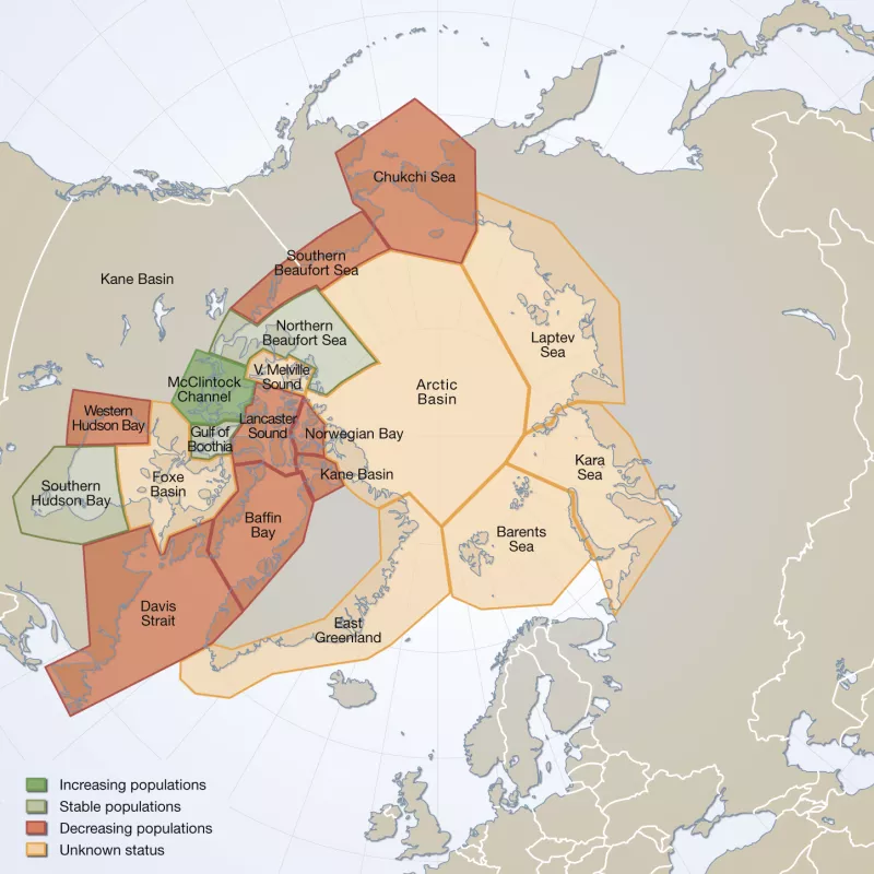
Since the start of the continuous satellite record in 1979, Arctic sea ice has declined in all seasons, particularly in summer. However, sea ice has not declined the same way in all places, and polar bear populations have experienced different fates in different parts of the Arctic. In October 2019, the International Union for Conservation of Nature/Species Survival Commission-Polar Bear Specialist Group (IUCN/SSC-PBSG) released an assessment of 19 polar bear subpopulations across the Arctic. The subpopulations are divided based on management needs and what biologists know about the movement and genetics of the bears. Although the researchers could not determine population health everywhere, they found declines in four subpopulations, stability in five, and an increase in two.
Although the study found a relationship between sea ice conditions and polar bear health, that relationship was not necessarily straightforward. In Hudson Bay, for example, female bear survival correlated strongly with sea ice conditions, but male survival correlated primarily with subsistence-hunting pressure from humans. Other factors could complicate the ice-bear relationship, such as the width of the continental shelf, the preferred habitat of seals (polar bears' main food source). In places where the continental shelf is narrow, such as the Beaufort Sea, poor sea ice conditions could exacerbate polar bears' difficulties in catching prey. Still, the study found greater population declines in areas with a higher number of reduced-ice days, such as the Beaufort Sea.
Sea ice and people
For early explorers of the polar regions, sea ice was a natural phenomenon that needed to be crushed, in the most literal of senses. However, for many communities living in the Arctic, their identity is closely tied to sea ice and its presence. Small changes in the climate or environment can have dramatic impacts on those whose lives depend on local access to natural resources.
Antarctica has no no permanent residents, though in 1959 the Antarctic Treaty System was signed, setting Antarctica aside as a scientific preserve that banned military activity on the continent. As such, Antarctica today hosts a number of different research stations to study the ice sheet, its ecology, and various natural processes.
By contrast, the Arctic is home to thriving populations —though relatively small compared to other regions on Earth—mostly concentrated along the coasts. Many communities closely rely on sea ice for travel and hunting, and to protect the coastline from strong winter storms.
As Arctic sea ice shrinks, the world looks upon the region for its potential industrialization, to open up shipping lanes and opportunities for resource extraction, but local communities worry about the environmental and cultural cost.
Arctic exploration
Compared to those who have lived in the Arctic for thousands of years, European explorers are relative newcomers. Europeans started venturing north into Arctic regions of Scandinavia and Russia only around a thousand years ago, with much exploration taking place in the eighteenth and nineteenth centuries.
Vikings from Scandinavia traveled to Greenland around A.D. 930, during an unusually mild period throughout most of the Northern Hemisphere. They settled for a time along the south and southwest coasts, the only habitable part of Greenland. For nearly five centuries the Norse settlements persevered, depending on their cattle, sheep, and goats, as well as on seal and caribou hunts.
Contacts between the Norse settlements and the outside world ceased in the late 1400s. As the weather got steadily colder, the pasture and farming lands shrank under the advancing ice and snow. The rapid cooling that signaled the beginning of the Little Ice Age in the early 1300s caused sea ice to expand over the North Atlantic, which made it impossible to navigate between Greenland and Iceland, trapping people in their settlements and halting trade.
Russians began exploring the northern regions of their country in the eleventh and twelfth centuries, and by the seventeenth century they had explored many Arctic islands. During the 1800s, many explorers searched for a Northwest Passage, a navigable route between the Atlantic and Pacific Oceans. Irish explorer, Sir Robert McClure, is credited with finding it in 1851, though he conducted much of his journey over land and ice, using sledges. From 1903 to 1906, Norwegian Roald Amundsen led the first expedition to successfully sail through the Northwest Passage. The first reported person to reach the North Pole is American explorer, Robert Edwin Peary. He reputedly accomplished this in 1909, just beating Frederick Cook. However there are doubts whether Cook reached the pole first, or whether either of them successfully reached the North Pole.
Changes to a way of life in the Bering Sea
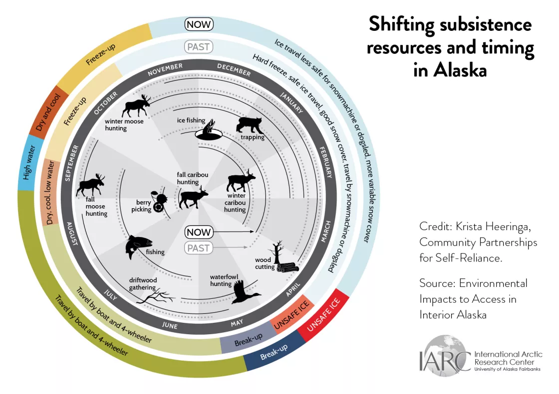
The Yup'ik and Iñupiat populations in Alaska closely observe the quality of sea ice throughout all seasons. Sea ice is an extension of the land for hunting and travel; it enables access to seals, whales, walruses, fish, crabs, and other marine life that would be more difficult to access otherwise.
Walruses weigh about 900 kilograms (2,000 pounds). The Iñupiat have used sea ice floes as platforms for butchering, rather than doing so in their small steel boats. As sea ice seasons have dramatically shortened in the Bering Sea, they have had to revise their harvesting methods.
In 2019, Bering Sea Elders authored a chapter in the Arctic Report Card, providing a report on environmental changes in the Arctic. The authors highlighted detrimental impacts of declining sea ice on marine mammals, fish, and seabirds. Delayed fall freeze up of sea ice, for example, leaves communities stranded for longer periods of the year from their traditional local travel routes, unable to access other communities or to hunt traditional foods. In communities not on road systems, travel by snowmobile over sea ice used to allow access to traditional hunting and fishing grounds, but as the ice thins, this form of travel has become riskier. The island community of Little Diomede in the Bering Strait traditionally used an ice runway, but by 2019, the ice had been too thin to support one for a decade, forcing the community to turn to less-reliable helicopter access. “In the northern Bering Sea, sea ice used to be present with us for eight months a year. Today, we may only see three or four months with ice,” the Elders write.
When sea ice in the spring melts too rapidly, it shortens the hunting season. Alaskan Elders point to recent decades as a period of considerable change. In the past, they predicted weather using traditional indicators such as clouds, winds, and currents. These indicators are no longer as reliable as they once were because of how rapidly the weather can shift.
More severe storms and coastal erosion
In the Arctic, the sea ice fastened to the coast, also known as shorefast sea ice, creates a buffer zone between the dynamic polar ice farther out and coastlines. As sea ice retreats and the timing of shorefast ice shrinks, violent storms beat coastal communities, sometimes collapsing coastlines, roads, and other infrastructure.
Communities have noticed an increasing rate at which large storms develop, which they believe is a result of diminishing sea ice. With less sea ice, stronger storms are possible. Sea ice also prevents large ocean waves from forming, so without sea ice, these waves reach land and can cause significant coastal erosion. With declines in Arctic sea ice extent, these bigger storms and higher waves are more common.
Reduced ice coverage, especially during the fall period, creates longer available sea distances for waves to develop, known as fetch. The faster the wind speed, the longer the fetch. More open sea areas also allow for increased storm surge heights.
Average annual erosion rates, according to the United States Geological Survey (USGS), doubled from historical levels of about 6 meters (20 feet) per year between the mid-1950s and late-1970s, to 14 meters (45 feet) per year between 2002 and 2007. In 2017, the USGS issued an updated assessment of erosion along the north coast of Alaska. The new assessment measured long-term (from the 1940s to the 2010s) and short-term (from the 1980s to the 2010s) shoreline change rates from transects along the Alaskan coast. The new assessment found long-term erosion in 84 percent of the transects, 35 percent eroding more than 1 meter (3 feet) per year, and 14 percent eroding more than 3 meters (10 feet) per year. The assessment found short-term erosion in 77 percent of the transects, 34 percent eroding more than 1 meter (3 feet) per year, and 17 percent eroding more than 3 meters (10 feet) per year.
Along a stretch of the Beaufort Sea, some cultural and historical sites, including Esook, a 100-year-old trading post, disappeared into the sea. Sandbags and shore structures attempt to protect the land and infrastructure in many of the villages. Though villages can be moved, and have already, relocation comes at great cultural and economic cost and with some concern that new sites might also be at risk from future erosion.
On August 16, 2016, residents of the village of Shishmaref, a village on Sarichef, a barrier island north of the Bering Strait, voted to relocate their community after decades of coastal erosion. Finding the funds to support such a move, however, was uncertain.
The change in erosion rates is likely the result of several changing Arctic conditions, including declining sea ice extent, permafrost thaw, increasing summertime sea-surface temperature, rising sea level, and possible increases in storm power and corresponding wave action. According to the Arctic Report Card: Update for 2020, since the early 2000s, erosion of permafrost coasts in the Arctic has increased, with the largest impact along the US and Canadian Beaufort Sea, where erosion rates increased between 80 and 160 percent when compared to the 1980s and 1990s.
More long-term work is needed to understand the interplay of these factors and how they drive changes in coastal erosion.
Industrialization of the Arctic
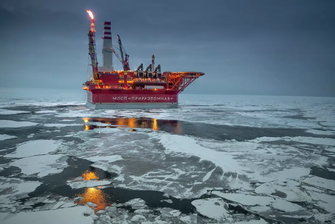
Large, but sparse, industrial operations take place in the Arctic with major consequences for communities, wildlife, and the environment. In Alaska, the Prudhoe Bay and over two dozen more producing oil fields sprawl across its North Slope. Pumping oil since 1977, Prudhoe Bay is the largest in Alaska and one of the largest in the United States, about 250 times the size of New York City’s Central Park. According to the Alaska Department of Environmental Conservation, the Prudhoe Bay oil fields and Trans-Alaska Pipeline have caused an average of 500 spills annually on the North Slope since 1996. Between 1996 and 2004, more than 1.9 million gallons of toxic diesel, crude oil, and hydraulic oil spilled.
According to the Arctic Council, recovery from spills in the Arctic is slower because of cold temperatures, the slower rates of plant growth, and the longer life span of animals. According to the 2014 Inuit Circumpolar Council report, the Inuit are very concerned about the environmental effects associated with industrialization of the Arctic, such as increased shipping. As one community member stated:
We travel all over the land and sea, and so do the animals we eat. When any kind of disruption in the natural order of things occurs—for example, an oil spill, dumping of waste, or noise from machinery or ships—the animals are affected. This automatically affects our health and well-being as well, because we are left with a choice between two bad options: (1) stop hunting the animals which supply us with our meat, which we would be a terrible tragedy for our culture and leave our communities without an affordable source of protein, or (2) continue to hunt and eat our traditional foods, with negative consequences for our health.
As sea ice extent shrinks and resources deplete in other parts of the world, mining and oil companies view the Arctic as an untapped frontier for oil, gases, and other rare Earth metals and minerals. To carry out this vision would require significant infrastructure development, from the construction of more Arctic ports, to the expansion of shipping supply routes, drilling rigs, service vessels, and the sprawl of new pipelines and roads on land. The effects of this development over newly accessible supply routes is of concern to Inuit communities, according to the ICC.
At the same time, it is unrealistic to imagine that renewable energy can replace extractive resources in Arctic economies single-handedly. Though some residents believe that reserves in the Arctic are best left undeveloped, economies like Norway and Alaska’s North Slope are heavily invested in oil and gas and continue to emphasize offshore exploration. From this perspective, policies must include guidelines endorsed by Arctic residents and communities, such as land use and marine spatial planning to boost different sources of economic growth, including fisheries development and tourism alongside extractive industry. Building more diversified regional and local economies will facilitate an easier transition to a post-petroleum scenario, whether by choice or due to market factors that make development of remote Arctic resources economically unattractive.
Resource extraction in the Arctic is not the only form of concern from industrialization. In Russian Siberia, many cities along the Arctic coast have factories. Not only do pollutants sink near their source to contaminate the local region, but sea ice traps these pollutants, distributing them throughout the Arctic as it circulates. A study published in 2020 in Nature confirmed that tiny plastic pieces from the breakdown of consumer products and industrial waste, known as microplastics, were everywhere in Arctic sea ice and the seawater beneath. The main source of microplastics is synthetic fibers, which the study suggested may be originating from fishing gear, laundering synthetic fabrics, and cigarette filters. Though it is difficult to pinpoint the exact origin of these fibers, potential sources include discharge from Siberian and Canadian rives, influx of contaminated Pacific and Atlantic waters, dirty water flushed from vessels working in the Arctic, and contaminants being blown in from other regions.
The opening of Arctic sea routes
The presence or absence of sea ice directly affects Arctic operations. While most of the Arctic is covered with perennial (year-round) sea ice, the Arctic Ocean is still a strategic sea route, for both commerce and the military. The Arctic Ocean provides the shortest route between Europe and Asia. However, this route is typically impassable because of sea ice. Ships must traverse around Africa's Cape Horn or through the Panama Canal to travel between Europe and Asia. If sea ice extent continues to decline, routes through the Arctic Ocean have already become navigable for part of the year.
Along Russia’s northern coast from Murmansk to the Bering Sea runs the Northern Sea Route, one of three main passages through Arctic waters. It is usually the first, and sometimes the only, Arctic shipping route open each summer and the last to ice over each fall. The route cuts 4,800 kilometers (3,000 miles) and 11 days out of travel between Europe and Asia compared to its southern option via the Strait of Malacca and Suez Canal.
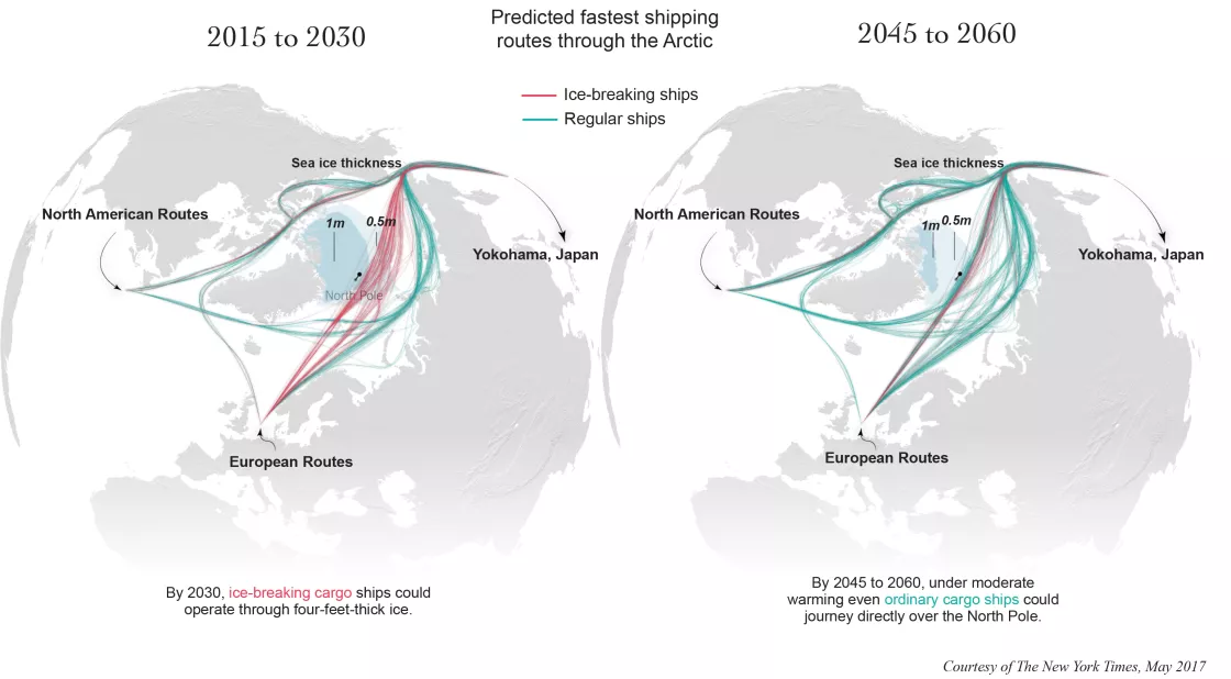
As global warming continues, a study shows that by 2030 routes over the North Pole could open for ice-breaking cargo ships capable of operating in ice up to four feet thick. By 2045 to 2060, the decline of Arctic sea ice under a moderate warming, which estimates greenhouse concentrations at 4.5 Watts per meter squared in the year 2100, could allow ordinary cargo ships to journey directly over the North Pole.
Increased shipping traffic, however, creates a set of new challenges and risks for wildlife and Arctic communities. Increase in noise pollution, disturbance of migratory paths, and increased likelihood of oil spills, trash, and debris, could have catastrophic consequences for migratory animals like whales. In the summer of 2020, for instance, an unusually high amount of trash washed up on the beaches of Western Alaska. As reported by Alaska Public Media, a local resident, Erika Apatiki of Gambell, spent one day picking up trash with her mother on a 3-mile stretch of beach; she filled up roughly 19 40-gallon trash bags full of plastic bottles, Butane bottles, empty milk bottles, and other debris. She said, “It’s actually pretty heartbreaking, especially since we see on the media that the whales are dying from plastic pollution, all over the world.”
Sea ice and geopolitics
As sea ice extent continues to shrink, the potential for international competition increases, posing a challenge to the traditions of cooperation and peaceful resolution since the founding of the Arctic Council in 1996. The Arctic Council is an intergovernmental forum, consisting of eight countries (Canada, Denmark, Finland, Iceland, Norway, Russia, Sweden, and the United States), which promote cooperation among the Arctic States and other Arctic residents to promote sustainable development and environmental protection in the Arctic. (The 2022 Russian invasion of Ukraine, however, substantially changed Arctic Circle governance.) The Arctic Council noted in a report to the United States Congress in 2021 that activities in the Arctic need to be closely monitored. Currently, there is no commercial fishing in the Central Arctic Ocean. With changes to the Arctic environment, including shifting migratory paths, influx of pollution, acidification of the ocean, and warming ocean temperatures, it is questionable whether existing fisheries are sustainable in the long term. The potential expansion of fishing boundaries, unregulated industrial activity, and increasing competition for resource extraction, may increase competition, whether political or military, between the United States, Russia, and China. For instance, in 2019, Russia claimed sole control of the international waters of the Northern Sea Route, something other countries continue to dispute.
Submarines have, however, historically used sea ice as the perfect cover to hide from surface ships and aircraft. German U-boats used sea ice as an escape route after attacking ships on the Russian coast during World War II. When the Cold War started, submarine operations in the Arctic became a crucial part of strategic defense for the United States and the Soviet Union. In 1958, the US submarine USS Nautilus was the first submarine to reach the North Pole and traverse under the ice across the entire Arctic. The cover provided by sea ice and the location of the Arctic Ocean—bounding the United States and the Soviet Union—provided the potential for submarines to surface through the ice near each country's coastline without warning, and launch missiles.
Scientists have also benefited from collaborations with the United States military, regarding sea ice observations. In the 1990s, several scientific cruises took place as part of the Scientific Ice Expeditions (SCICEX). These operations were military in nature, and most details remain classified. However, submarines participating in SCICEX collected many sea ice and ocean observations that are otherwise difficult to obtain. The most important observations regarding sea ice were estimates of ice thickness from an upward-looking sonar. A comparison of recent data with data from submarines in the 1950s through the 1970s shows that sea ice has thinned by about 40 percent. NSIDC archives and distributes data from SCICEX in the Submarine Upward Looking Sonar Ice Draft Profile Data and Statistics data set.
Research stations in Antarctica
Antarctica has no permanent residents, but several thousand people live on Antarctica during parts of the year, supporting scientific research at various stations. In 1959, the United States and 11 other countries signed the Antarctic Treaty, banning military activity with the end goal of scientific exploration. Several governments have set up permanent research bases that are widely distributed over the continent. Many other stations operate seasonally, totaling over 70 research stations.
McMurdo Station, the logistics hub of the US Antarctic Program, is the largest Antarctic station. Ships resupply the station each year after an icebreaker clears a path through the sea ice. During years when sea ice is thicker and more prevalent, the icebreaker's job is more difficult, time-consuming, and costly.
During winter, thick sea ice encapsulates Antarctica's Ross sea and McMurdo Sound. Summer releases this area from sea ice as it retreats and thaws. But in 2004, a large iceberg, called B-15A, wedged itself aground near McMurdo Station. The iceberg was more than 3,000 square kilometers (1,200 square miles) in area and up to 270 meters (886 feet) thick. Until it broke up and began drifting away in 2005, it blocked currents and winds that normally pushed sea ice away from McMurdo. The sea ice was thicker and more abundant than usual, which made it more difficult for icebreakers to clear a path to McMurdo, severely delaying and complicating resupply of the base.
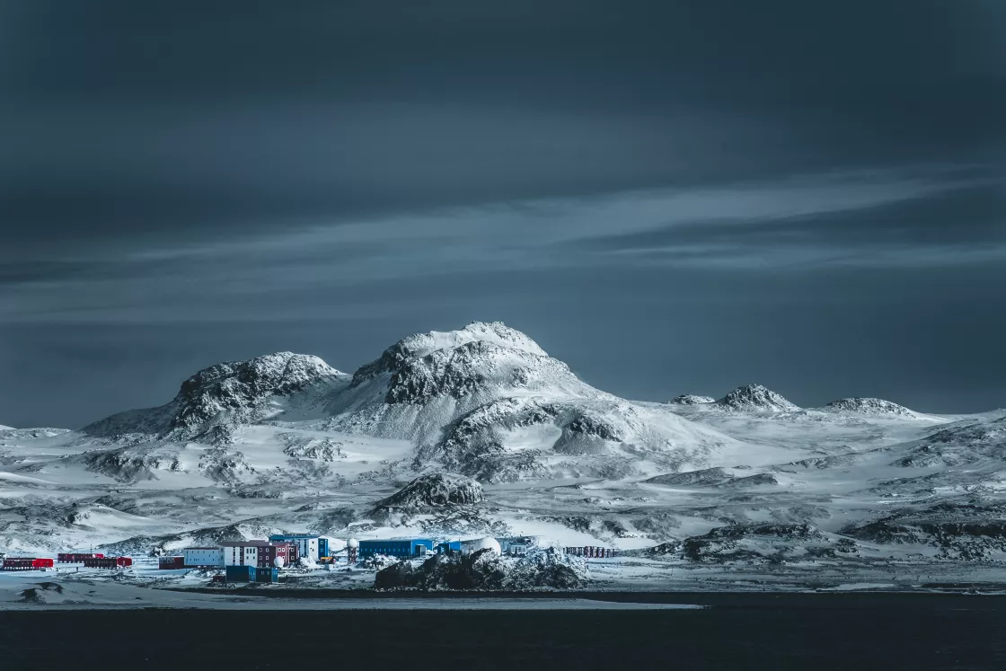
Other research stations, such as the British Rothera Station, have similar issues of limited access because of sea ice or fast ice, sea ice that adheres to the coastline. For this reason, there are many bases set on King George Island near the northern tip of the Antarctic Peninsula, where the sea ice season is brief. Other bases are set in areas of persistent polynyas, such as Italy’s Mario Zucchelli Station and South Korea’s Jang Bogo Station, set in a large persistent polynya called Terra Nova Bay.
Sea ice and the environment
Do changes in the formation and distribution of sea ice affect our global climate? Yes. The role of sea ice is greater than you might think.
Greater warming leads to greater melting
The sun's rays strike the polar regions at a more grazing angle than over equatorial regions, where the rays strike at a more direct angle. The sun's angle is the primary reason why the polar regions are cold and the equatorial regions are warm.
Sea ice is nearly white, so most of the sunlight that hits the sea ice surface is reflected back into space; thus, it has a high reflectivity, or albedo. High albedo helps keep the polar regions cold because the sunlight reflected back into space does not warm the surface. When the climate changes enough to warm the Arctic and to melt sea ice, the polar regions have less of a reflective surface. More heat is absorbed, which causes more melting, which amplifies the warming. This cycle is known as a positive feedback loop that ultimately alters the circulation of the atmosphere.
Atmospheric & oceanic circulation
The atmosphere and ocean act as “heat engines,” always trying to restore a temperature balance by transporting heat it collects at the equator toward the poles. Our weather is a manifestation of this phenomenon. Low-pressure systems, such as storms, which can be especially strong in winter, are one of nature's best ways of transporting heat poleward by atmospheric circulation. The oceans, by contrast, tend to transport heat in a slower and less violent fashion. Changes in the amount of sea ice alter how cold the poles are, which could affect atmospheric and ocean circulation.
Ocean currents transport heat from the equator to the poles through a heat- and salinity-driven process called thermohaline circulation, also known as the Great Ocean Conveyor Belt. Warm water moves from the equator northward along the ocean surface and eventually cools. As it cools, it becomes denser and heavier. Then, it sinks. This cold water then moves south along the lower part of the ocean and rises near the equator to complete the cycle. Like the atmospheric heat transport discussed earlier, this is a natural process that contributes to the observed temperature balance across the Earth. It also explains why Europe is relatively warm for its latitude. As northward flowing surface water in the Atlantic Ocean cools, heat is released to the atmosphere, which then warms the continent.
Thermohaline circulation can be disrupted if the ocean surface grows fresher. How might this happen? The biggest potential driver is melt from the Greenland Ice Sheet. Meltwater from Greenland is fresh, which is less dense than the ocean's salt water and thus less prone to sink. So more Greenland melt water can prevent sinking and inhibit the thermohaline circulation.
Sea ice also has an effect on the circulation. Sea ice melt freshens the ocean surface and impedes thermohaline circulation. But a bigger factor is wintertime sea ice growth in the Labrador Sea and the northern Atlantic Ocean off the southeast coast of Greenland. Whether in the Arctic or Antarctic, ice formation expels salt, so ice growth adds salt to the ocean surface, making ocean surface water denser and causing it to sink. By sinking, ocean water draws surface waters from the south to replace it. In other words, the sinking saline water “pulls” warmer surface waters from the south, like a conveyor belt, where those waters cool and sink. If sea ice growth is reduced in these regions, there will be less sinking, which will slow the conveyor belt.
The Arctic Ocean itself is affected by freshwater, particularly through river runoff into the Arctic Ocean. Although it contains only about 1 percent of the global ocean's volume, the Arctic Ocean collects more than 10 percent of the world's river discharge. Thanks to increasing precipitation at high latitudes, driven by rising global temperatures, river discharge into the Arctic is increasing. According to the NOAA Arctic Report Card: Update for 2018, from 1976 to 2017, discharge of Eurasian rivers into the Arctic increased by an estimated 3.3 ± 1.6 percent per decade; discharge from North American rivers rose an estimated 3.3 ± 1.6 percent per decade. The Arctic Report Card: Update for 2022 reported that long-term observations of North American and Eurasian rivers continued trending upward.
Sea ice movement & salinity
Although the ocean is salty, the sea ice on top of the Arctic Ocean is fresher. The older the ice, the fresher the surface. Sea ice becomes fresher as the freezing process expels salt into the water as ice forms. Multiyear ice can be fresh enough to drink when melt ponds pool on its surface.
When the ice moves south through the Fram Strait into the North Atlantic, it melts, creating a layer of fresher water over the ocean surface. This fresh water is less dense than salty water, so it tends to stay at the top of the ocean. This lower density discourages the normal process of sinking at high latitudes (poles) that supports thermohaline circulation, which makes it harder to move the warm water north from the equator. Strong evidence shows that this stagnation process happened over a period of several years in the late 1960s and early 1970s, when extra fresh water entered the North Atlantic and affected the climate of Northern Europe. Scientists call this event the “Great Salinity Anomaly.”
While this process involves the transport of ice out of the Arctic, other processes are at work within the Arctic Ocean itself.
Heat exchange between the ocean and atmosphere
During winter, the Arctic's atmosphere is very cold. In comparison, the ocean is much warmer. The sea ice cover separates the two, preventing heat in the ocean from warming the overlying atmosphere. This insulating effect is another way that sea ice helps to keep the Arctic cold. But heat can escape rather efficiently from areas of thin ice and especially from leads and polynyas, small openings in the ice cover. Roughly half of the total exchange of heat between the Arctic Ocean and the atmosphere occurs through openings in the ice. With more leads and polynyas, or thinner ice, the sea ice less effectively insulates the ocean from the atmosphere. The Arctic atmosphere then warms, which, in turn, influences the global circulation of the atmosphere.
Impacts of climate change on sea ice
In the Arctic, sea ice extent is declining, with less old and thick ice and more young and thin ice. By contrast, Antarctic sea ice shows a lot of variability. Also, most of the Antarctic sea ice melts out annually, so it has little old and thick ice. The geographic differences of the polar regions and how sea ice spreads is part of the reason. Read more about the differences between Arctic and Antarctic sea ice.
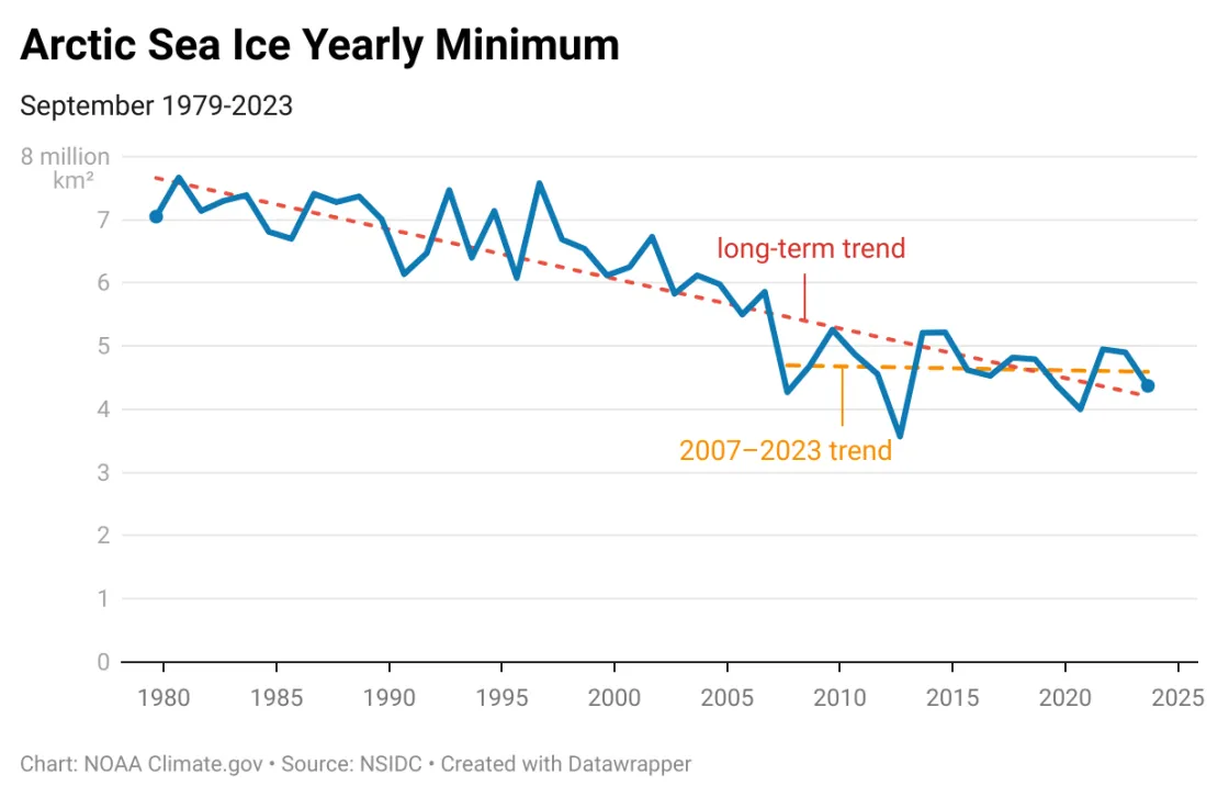
Satellites have shown annual fluctuations in Arctic sea ice since 1972, and have provided nearly continuous monitoring of sea ice conditions since November 1978. From November 1978 through 2020, Arctic sea ice extent declined in all months, with the smallest decline in April, and the largest decline in September. Over the same period, Antarctic sea ice showed an overall slight positive trend in all months except November, with the greatest increase in March. However, it is important to remember that Antarctic sea ice is “noisy,” meaning a lot of year-to-year variation. In turn, this causes trend values to often change substantially over relatively short periods of time. After setting record-high maximum extents each September from 2012 through 2015, the Antarctic reached record low maximum extents in February 2017, 2018, 2022, and 2023. Unlike Antarctic sea ice, Arctic sea ice shows a clear decline. Arctic sea ice set its record-lowest summer minimum extent in 2012 and second-lowest extent in 2020, both dipping below 4.0 million square kilometers (1.54 million square miles).
By 2023, 45 years of satellite record became available. Most notably, minimum extents in the last 17 years of the time series (2007 to 2023) are the lowest 17 in the 45-year record. The overall, downward trend in the minimum extent from 1979 to 2020 is 13.4 percent per decade relative to the 1981 to 2010 average, although there is little trend since 2007.
Arctic and Antarctic sea ice extent changes
The spring and summer weather conditions play an important role in the Arctic minimum extent and the spatial distribution of ice at the end of summer, and help determine if a particular year will be a record low. For example, in 2007, persistent winds through the summer helped to contract the Arctic sea ice extent to a new minimum record. In 2012, conditions were less favorable to ice retreat through the summer, although a strong cyclone in early August helped break up the ice and enhance melt. Regardless of weather patterns, the Arctic September ice extent shows a consistent downward trend in extent and thickness over the satellite record.
Combined with record low summertime extent, Arctic sea ice has exhibited a new pattern of poor winter recovery. In the past, a low-ice year would be followed by a rebound to near-average conditions, but 2002 was followed by two more low-ice years, both of which almost matched the 2002 record. Although wintertime recovery of Arctic sea ice improved somewhat after 2006, wintertime extents remained below the long-term average. In 2015, 2016, and 2017, Arctic sea ice set three consecutive record lows for its wintertime maximum extent. In 2018, Arctic sea ice maximum extent was the second lowest in the satellite record.
Over the course of the satellite record dating back to 1979, Antarctic sea ice exhibited a mix of above- and below-average extents with a minimal trend. In September 2014, Antarctic sea ice reached its highest extent on record. Over the years 2013 to 2015, Antarctic sea ice extents were mostly above the long-term average. Beginning in 2016, Antarctic sea ice extents mostly fell below the long-term average. In 2023, Antarctic sea ice reached record-low extents at both the time of the annual minimum (February) and maximum (September). The September 2023 low extent in Antarctic sea ice was the lowest on record by a wide margin.
The mix of above- and below-average Antarctic ice extents over the long term suggested that natural variability historically played a larger role in sea ice behavior than climate change. Multiple studies linked sea ice trends in Antarctica to changes in the Pacific Ocean. Determining whether the change in observed Antarctic sea ice extents starting in 2016 marked a long-term shift will require more observations of sea ice extents in the coming years.
Decline in Arctic sea ice thickness
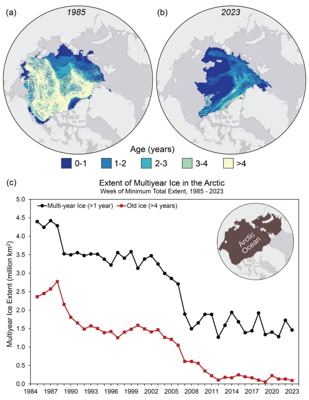
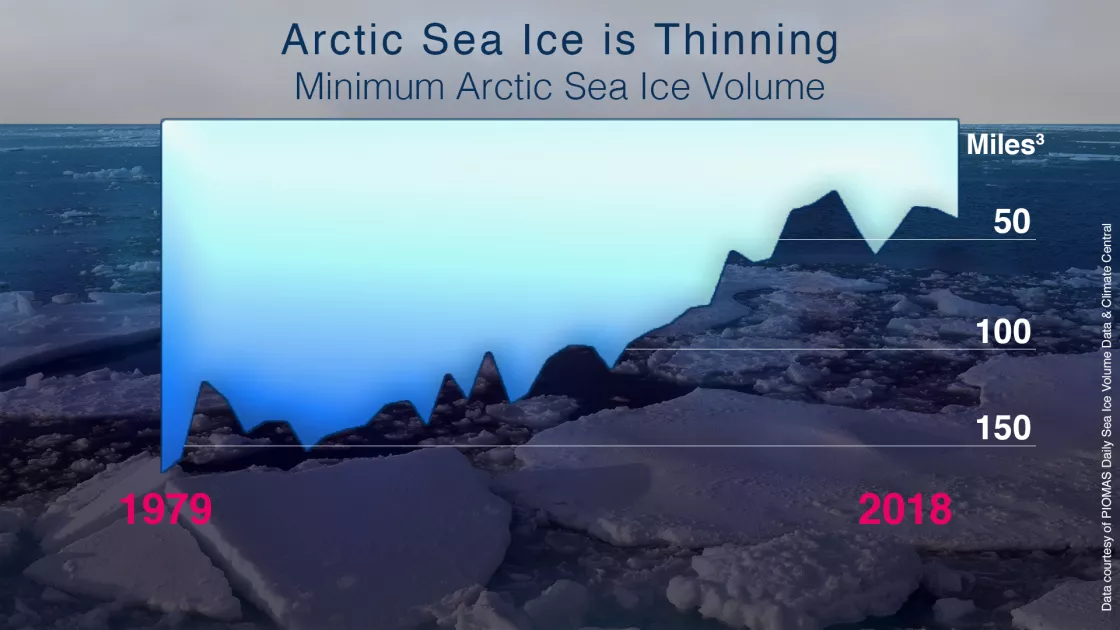
Freshly formed sea ice can be nearly paper thin, but the longer it lingers—surviving each melt season—the thicker it gets. When sea ice remains until the following winter, it is classified as multiyear ice, which can measure 4 to 5 meters (12 to 15 feet) thick. However, since the 1950s, Arctic sea ice has been thinning.
Sea ice thickness and sea ice age are not the same thing, but sea ice age provides a proxy for thickness. Researchers of a 2020 study found that in 1987, about 35 percent of the ice pack was at least four-years old, and a quarter of that ice was at least nine-years old. By 2020, less than 5 percent of the ice pack was at least five-years old, and virtually none of the ice was at least nine-years old. Overall, multiyear sea ice has remained low in the Arctic, with little trend since 2007. Most ice is first-year ice, which is only 1 to 2 meters (3 to 6 feet) thick.
However, ice thickness is difficult to measure, especially on a large scale. Arctic sea ice spans millions of square miles and is constantly on the move, swept around by winds and ocean currents. Scientists must use a variety of data sources and analysis techniques to study sea ice thickness including satellite data, airborne remote sensing data, modeling, and even data observations taken from submarines.
In 2010, Ron Lindsay of the Polar Science Center Applied Physics Laboratory at the University of Washington published the Unified Sea Ice Thickness Climate Data Record, 1947 Onward. This comprehensive climate data record resulted from a concerted effort to collect as many observations as possible of Arctic and Antarctic sea ice draft, freeboard, and thickness. Its clear documentation allows the scientific community to better utilize this considerable body of observations. It includes data from moored and submarine-based upward looking sonar (ULS) instruments, airborne electromagnetic (EM) induction instruments, and satellite laser altimeters on the NASA Ice, Cloud, and land Elevation Satellite (ICESat). The record is periodically updated and housed at NSIDC by the NOAA@NSIDC data management program.
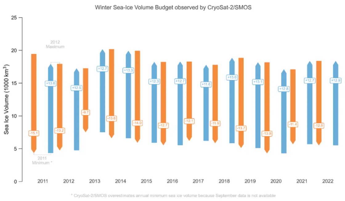
ICESat-2, launched in September 2018, measures the elevation of glaciers, sea ice, forests, lakes and the changing ice sheets of Greenland and Antarctica. The NASA Operation IceBridge bridged the gap between ICESat and ICESat-2, deploying a fleet of research aircraft to monitor the poles. Data from all ICESat, IceBridge, and ICESat-2, starting with data from 2003 onward, are available through the NASA NSIDC Distributed Active Archive Center (DAAC). Another satellite that measures thickness is the European Space Agency (ESA) CryoSat-2, launched in 2010, which like ICESat and ICESat-2 measures the elevation of Earth’s ice-covered regions. The NSIDC DAAC distributes a NASA-developed sea ice thickness product from CryoSat-2.
Decline causes
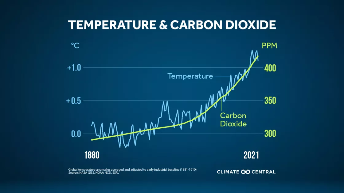
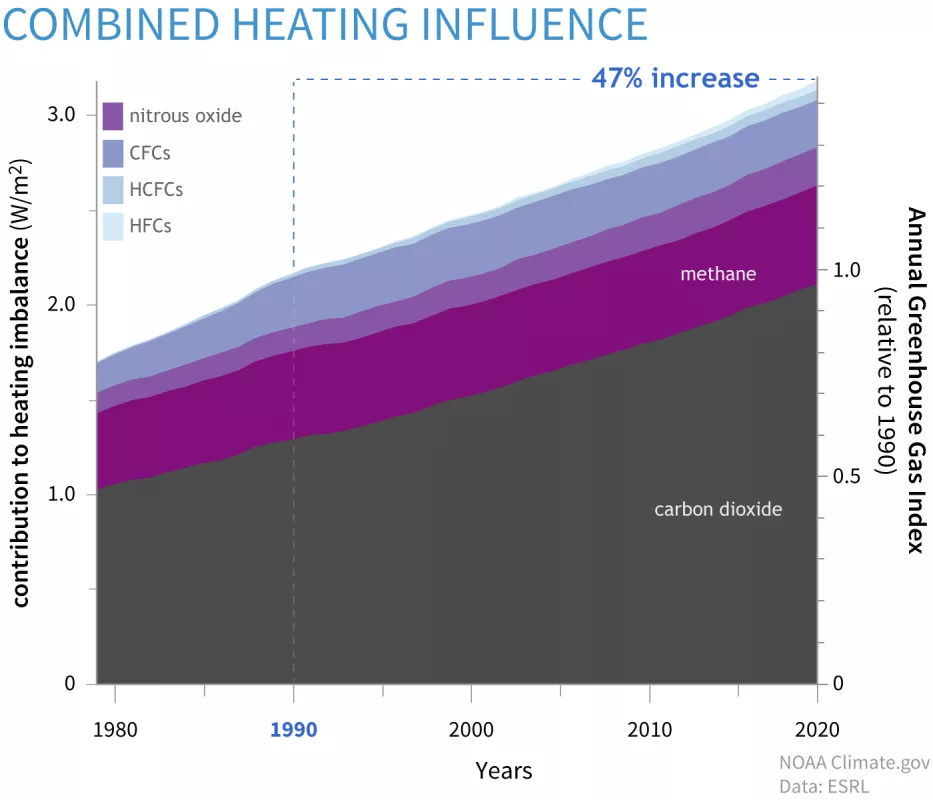
Global warming is the primary cause of the sea ice decline in the Arctic. Human activities increase greenhouse gas emissions such as carbon dioxide and methane that trap heat, causing average global temperatures to rise.
But sea ice decline is caused by a complicated combination of factors resulting from the warming and from climate variability. The Arctic Oscillation (AO) is a see-saw pattern of alternating atmospheric pressure at polar and mid-latitudes. The positive phase produces a strong polar vortex, with the mid-latitude jet stream shifting northward. The negative phase produces the opposite conditions. From the 1950s to the 1980s, the AO flipped between positive and negative phases, but it entered a strong positive pattern between 1989 and 1995. So, the acceleration in the sea ice decline since the mid-1990s may have been partly triggered by the strongly positive AO mode during the preceding years that flushed older, thicker ice out of the Arctic. However, since 1995, the relationship between the AO and summer sea ice has weakened. Even under negative AO phases, summer extents have continued to be extremely low. Still other factors also played a role.
In the Beaufort Gyre, a major ocean current north of Alaska, young sea ice matures. However, it is leaving this nursery as a result of warming along the Alaskan and Siberian coasts. In the past, sea ice in this gyre could remain in the Arctic for many years, thickening over time. Beginning in the late 1990s, sea ice began melting in the southern arm of the gyre, thanks to higher air temperatures and more extensive summer melt north of Alaska and Siberia. Moreover, ice movement out of the Arctic through Fram Strait continued at a high rate despite the change in the AO. Thus, warming conditions and wind patterns have been an important component of the steeper decline since the late 1990s. Sea ice may not be able to recover under persistent warm conditions. Scientists agree that the Arctic will be ice free during at least part of the summer, but the question is how soon. Some estimates suggest that during summer the Arctic will be free of sea ice, meaning covering less than 1.0 million square kilometers (386,000 square miles) of the Arctic Ocean, before 2040, while others suggest later decades. A 2024 study concludes that ice-free conditions in September “are likely to occur by 2050.”
NSIDC scientist Mark Serreze published a study in 2018 indicating that spring melt seasons have started earlier and continued for a longer period throughout the year. This conclusion was based on examining the long-term satellite record dating back to 1979. Even more disquieting, NSIDC scientist Julienne Stroeve published a study in 2007 comparing actual Arctic sea ice decline to the Intergovernmental Panel on Climate Change (IPCC) Fourth Assessment Report (AR4) projections, showing that observed ice loss is faster than any of the IPCC AR4 models have predicted. Stroeve and colleague Dirk Notz of the Alfred Wegener Institute in Germany published a study in 2016 indicating that under the Paris Agreement limiting global warming to 2°C (3.6°F), Arctic sea ice will almost inevitably disappear during summer. But the summer ice can likely be saved if warming is limited to 1.5°C (2.7°F).
