The Wilkins Ice Shelf is one of many thick slabs of ice that cling to Antarctica’s coast. Most of the continent’s ice sheet ends in one of these ice extensions that floats on the surrounding ocean water. Like the Larsen Ice Shelf, the Wilkins Ice Shelf lies in the Antarctic Peninsula region, but the Wilkins lies southwest of the Larsen, and in fact is attached to large offshore islands on the west side of the peninsula. Similar to the Larsen Ice Shelf, the Wilkins Ice Shelf has experienced a series of rapid disintegrations in the past few decades.
Driven by warming temperatures, the disintegrations resulted from years of increased surface melting, and a persistent layer of warm ocean water under the shelf. The shelf grew thinner and less stable. Both surface meltwater and seawater seeping into the porous snow on top of the ice shelf contributed to the decreasing stability.
Compared to the Larsen Ice Shelf, the Wilkins has lost less ice, but its disintegration activity has still caused concern among researchers because of its rapidity, and the possibility that the processes that drove the rapid break-ups will spread to other ice shelves as climate warms around the Antarctic coast. One Wilkins disintegration unfolded in mere hours. Another disintegration occurred during the Southern Hemisphere winter.
About the Wilkins Ice Shelf
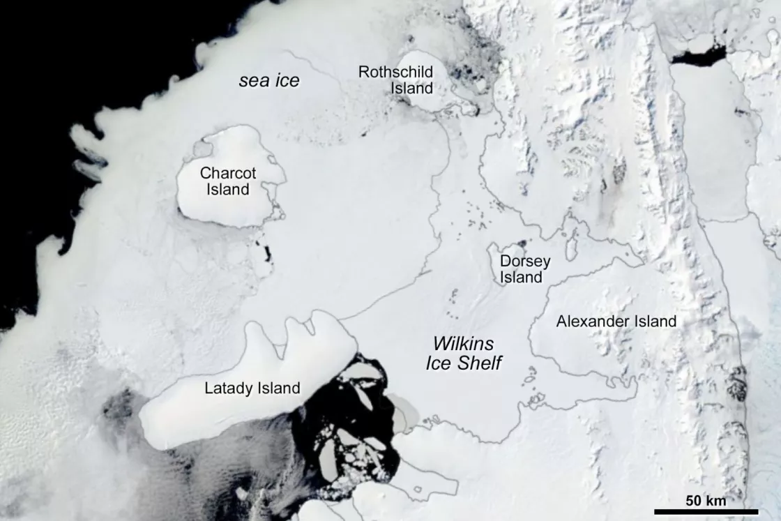
The Wilkins Ice Shelf rests on the west side of the Antarctic Peninsula, attached to the large Alexander Island and a number of smaller ice-covered islands. At roughly 70.5°S, 72.5°W, the Wilkins Ice Shelf is situated roughly 300 kilometers (185 miles) southwest of the Larsen. At the start of the 21st century, the Wilkins Ice Shelf had a maximum thickness of 200 to 250 meters (656 to 820 feet), although some areas were considerably thinner (150 meters).
Ice shelves are generally seaward extensions of glacier flow off ice sheet masses, but the Wilkins is somewhat different. While the southern portion of the Wilkins is fed by glaciers, glaciologists studying the shelf surmise that much of it likely formed from the accumulation of snow on multiyear sea ice that held fast to the shore through many melt seasons. Scientists suspect that the ice shelf has existed for at least a few centuries, but no longer, or the ice flowing off the glacier would extend across the entire ice shelf
Warmer temperatures
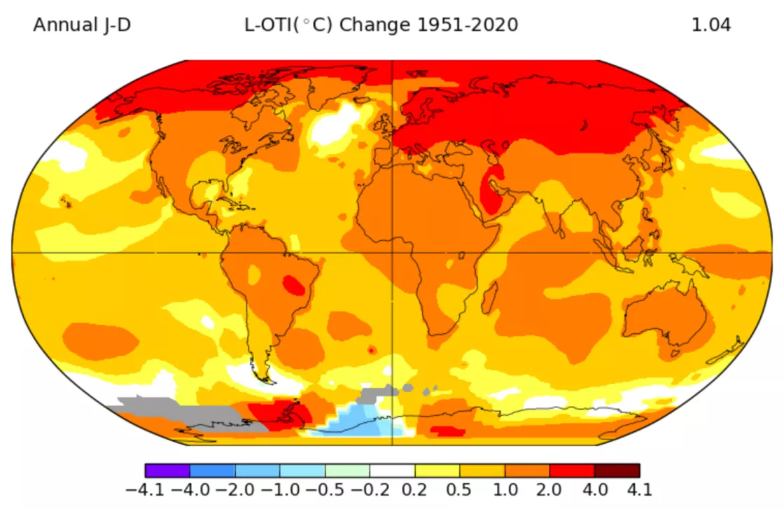
Data from NASA’s Goddard Institute for Space Studies (GISS) show that between 1951 and 2020, the Antarctic Peninsula counted among the fastest-warming places on Earth, rivaling portions of the Arctic. After 2010, the region’s warming trend stalled, replaced by steady to slightly cooling temperatures.
The warmer conditions that prevailed for decades along the Antarctic Peninsula placed multiple pressures on the peninsula’s ice shelves, including the Wilkins.
Wilkins Ice Shelf disintegration timeline
Early 1990s through early 2000s: Northern portions of the Wilkins Ice Shelf break up, but the ice fragments remain in place, welded together by sea ice.
Late February 2008: Satellites observe a disintegration event on the Wilkins Ice Shelf, changing the ice shelf’s front in a matter of hours. The disintegration leaves just a thin strip of ice connecting the shelf to Charcot Island.
June and July 2008: Isolated areas of the Wilkins disintegrate. This event is notable because it occurs during the Southern Hemisphere winter.
October and November 2008: New rifts appear in the ice bridge connecting the Wilkins Ice Shelf to Charcot Island.
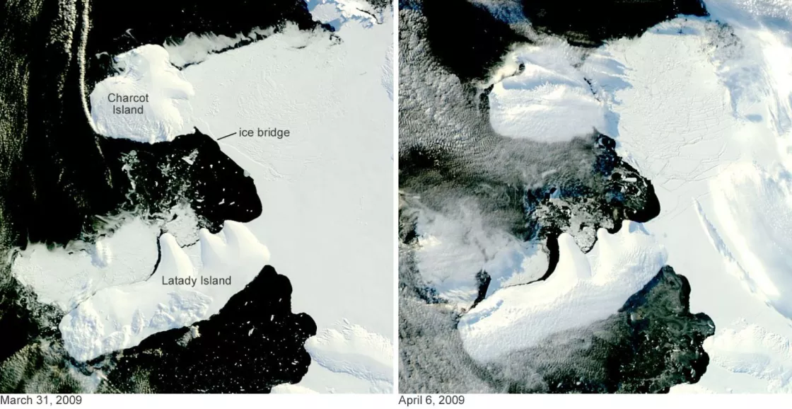
Early April 2009: The ice bridge to Charcot Island shatters.
March 2013: Evidence of further shelf disintegration appears in high-resolution satellite imagery. This continued breakup event may result from changes in the ice shelf’s shape.
See below for more information on each timeline event.
Events of the 1990s and early 2000s
As of the early 1990s, the Wilkins Ice Shelf has a total area of 17,400 square kilometers (6,700 square miles). Breakup events in 1998 and the early 2000s reduce the ice shelf’s size to roughly 13,680 square kilometers (5,280 square miles). Rather than drifting out to sea, however, the ice shelf fragments remain frozen in place.
Late February 2008
When the Moderate Resolution Imaging Spectroradiometer (MODIS) sensor on NASA’s Terra satellite observes the Wilkins Ice Shelf at 14:00 UTC on February 28, 2008, the ice shelf looks no different from how it has looked for years. The ice shelf front appears intact. But when the MODIS sensor on NASA’s Aqua satellite observes the shelf at 21:10 UTC the same day—just seven hours later—the ice shelf’s disintegration is discernible. The shelf front has retreated, and where seemingly intact ice existed hours earlier, the shelf is now a mixture of ice chunks and water. When Terra MODIS observes the shelf again at 13:05 UTC on February 29, 2008, the disintegrated area has expanded.
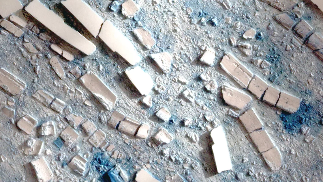
Scientists studying the Wilkins disintegration supplement MODIS imagery with extremely high-resolution imagery from Taiwan’s Formosat-2 satellite. The Formosat observations provide a closeup view of the ice and slush left in the aftermath of the disintegration.
The disintegration of the Wilkins in late February 2008 leaves just a thin strip of ice, only 6 kilometers (4 miles) wide, connecting the shelf to Charcot island. By May 2008, continued ice retreat has narrowed this strip to just 2.7 kilometers (1.7 miles) wide.
June and July 2008
Disintegration continues in isolated areas of the Wilkins Ice Shelf. This event occurs in the Southern Hemisphere winter. Most ice shelf disintegrations observed up to this point have occurred in summer, and have been linked to areas of surface meltwater ponds. The timing of this disintegration event—during the coldest, darkest time of year in Antarctica—means the breakup events cannot easily be explained by the same mechanisms that drive summertime disintegration.
October and November 2008
Using observations from the Envisat Advanced Synthetic Aperture Radar (ASAR), the European Space Agency reports rifts in the thin ice bridge connecting the rest of the Wilkins Ice Shelf to Charcot Island. Spanning some 160 kilometers (100 miles), the ice bridge is only a few kilometers wide, so its deterioration can be expected. Still, the rifts surprise scientists because they appear to have occurred during the Southern Hemisphere winter.
Early April 2009
The remaining ice bridge to Charcot Island splinters. MODIS observations can narrow down the date of the break, but not the precise moment, due to intervening cloud cover. When the MODIS sensor on NASA’s Terra satellite passes overhead on March 31, 2009, the ice bridge remains intact. When the MODIS sensor on NASA’s Aqua satellite passes overhead on April 6, 2009, the ice bridge has broken.
March 2013
High-resolution satellite imagery indicates that more ice blocks have broken off the Wilkins Ice Shelf. Observations from the WorldView-2 satellite, available from DigitalGlobe (later Maxar) capture ice fragments of various sizes along the shelf front.
Total losses from the Wilkins Ice Shelf
In the early 1990s, the Wilkins Ice Shelf had a total area of 17,400 square kilometers (6,700 square miles). Events occurring between 1998 and the early 2000s reduced the shelf’s area to roughly 13,680 square kilometers (5,280 square miles). In 2008, a series of disintegrations and large iceberg calvings shrunk the area of stable ice shelf to roughly 10,300 square kilometers (4,000 square miles).
Although the disintegration and calving events reduced the shelf size, the southern portion of the Wilkins Ice Shelf has remained intact as of 2021. The breakup events reduced the ice shelf’s size, but substantial shelf area remains, including the glacier-fed southern portions.
NSIDC provides imagery of the Wilkins and other ice shelves through the Images of Antarctic Ice Shelves pages.
Causes
The Wilkins Ice Shelf disintegrations that occurred during the Southern Hemisphere summer were likely driven by a variation of the same mechanism that drove the 2002 breakup of the Larsen Ice Shelf: warmer air temperatures formed melt ponds on the ice shelf surface. The meltwater flowed into and filled crevasses on the ice shelf surface. Water is denser than ice, and water filling an ice shelf crack pushes the crack downward, eventually slicing through the ice. Pieces break off the shelf in a rapid disintegration.
The wintertime disintegrations on the Wilkins Ice Shelf in June and July 2008 cannot be explained by the same process. Air temperatures would have been too cold to allow surface meltwater in winter. Other effects must have driven the wintertime disintegration events. These pressures include new stresses in the shelf after changes in shape, brine infiltration, and the persistence of meltwater below the surface.
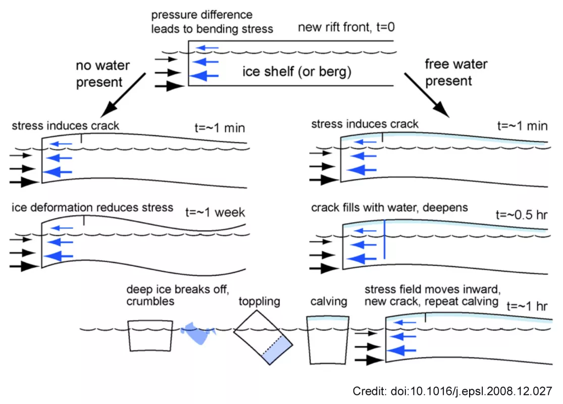
A 2009 study led by Ted Scambos, a University of Colorado Boulder glaciologist, presented a model of ice shelf disintegration to explain the Wilkins Ice Shelf breakups. One factor the study examined was the effect of ocean water on the ice front. The front of an ice shelf is thick enough to tower above the sea surface, presenting a cliff face to the ocean water, but the ice front extends well below the water line as well. The ocean water exerts pressure—buoyant force—on the shelf front below the water line, but that force is not uniform down the entire ice front. The water pressure increases with depth. The greater water pressure on the lower shelf front rotates the front’s top edge outward. Over time, this flexes the shelf and changes its shape. This change in shape can create new stresses within the shelf that may eventually destabilize it and make disintegrations more likely.
In the short term, what happens after the shelf is deformed by buoyant force on the front depends on the presence or absence of a surface (or near-surface) water layer. In the presence of the water layer, the ice shelf can begin to rapidly disintegrate as the water finds and fills cracks formed by the shelf’s flexing. In the absence of a water layer, the shelf front is stabilized in the short term, but the ice shelf changes shape.
The 2009 study also concluded that, below the surface, a layer of brine-soaked firn might destabilize an ice shelf by infiltrating the ice shelf’s firn layer. Firn is compacted snow that is more than a year old. Water—either fresh meltwater or salty brine—can occupy the spaces between firn crystals. Brine layers in ice shelves are rather uncommon, but where they occur, they can contribute to destabilization.
Due to its salt content, brine has a lower melting point than freshwater, enabling the brine to remain liquid in colder conditions. Brine is also denser than freshwater, so brine is even more effective at cutting through the ice by increasing the pressure at a descending crack tip. Brine’s ability to break up an ice shelf is limited, however. It wicks laterally into the ice shelf’s firn, so brine can exist only as high as the ocean’s water line.
For most ice shelves, the brine’s rate of infiltration into the ice shelf’s front is slower than the seaward flow of ice. So, brine infiltration usually affects a limited area. Where it does infiltrate; however, it can fill crevasses and cut through the ice. Brine can destabilize the ice shelf in winter.
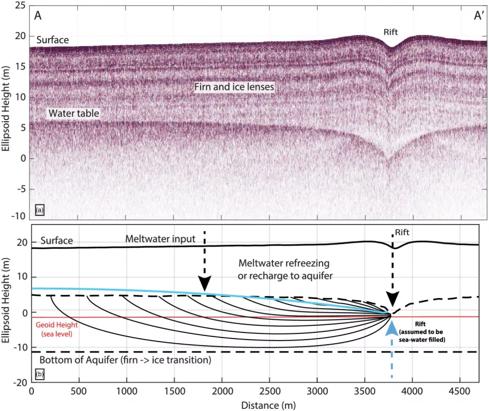
Though it is less dense than brine, freshwater has also destabilized the Wilkins Ice Shelf. Since the 2009 study, using newer remote sensing tools, researchers have ascertained that large areas of the Wilkins Ice Shelf’s firn layer are likely filled with fresh meltwater, creating what is known as a firn aquifer. Firn aquifers are not uncommon on mountain glaciers in warmer climates, but were only discovered on ice sheets in 2011. Fieldwork on the shelf in December 2018 confirmed the presence of a firn aquifer containing substantial quantities of liquid water. Besides providing space for water to fill, firn can provide sufficient insulation to keep water above freezing throughout the winter. As explained in a 2020 paper, the 2018 fieldwork uncovered evidence that meltwater percolated through the firn, and could move several kilometers laterally and drain into rifts. With a mobile (laterally flowing) layer of water above sea level, firn aquifers can have the same fracturing effect as melt ponds. As of 2021, this is currently the best explanation for the series of Wilkins disintegrations in the early 2000s.
Consequences
The breakup events observed in 2008 allowed glaciologists to better understand how ice shelves respond to environmental changes. Years after the disintegration events, a substantial portion of the Wilkins Ice Shelf remains, and nearby sea ice has actually grown.
The Wilkins Ice Shelf is partially fed by land-based ice partially formed from sea ice that has stayed in place for many years. This means that the Wilkins Ice Shelf disintegration has a very low potential for changing sea level. In the aftermath of the Wilkins disintegration, there is less glacial ice flowing faster into the ocean. Still, the Wilkins disintegration events show that warming temperatures can exact a toll on ice shelves after centuries of stability.
References
Scambos, T., H.A. Fricker, C.-C. Liu, J. Bohlander, J. Fastook, A. Sargent, R. Massom, and A.-M. Wu. 2009. Ice shelf disintegration by plate bending and hydro-fracture: Satellite observations and model results of the 2008 Wilkins ice shelf break-ups. Earth and Planetary Science Letters, 280: 51-60. https://doi.org/10.1016/j.epsl.2008.12.027
Montgomery, L., C. Miège, J. Miller, T.A. Scambos, B. Wallin, O. Miller, D.K. Solomon, R. Forster, and L. Koenig. 2020. Hydrologic properties of a highly permeable firn aquifer in the Wilkins Ice Shelf, Antarctica. Geophysical Research Letters, 47(22): e2020GL089552. https://doi.org/10.1029/2020GL089552
