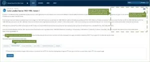
The process of accessing data from NSIDC is evolving, and with it, the design and function of data set landing pages. The first improvements, released on March 6, reorganize the layout of these pages. The most noticeable change will be the consolidation of data download functionality in a single tab, as illustrated below.
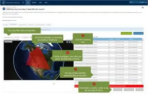
For certain data sets, new functionality will be available that allows users to temporally or spatially limit data files before ordering:
This functionality is currently being tested on the following data sets:
- MODIS/Terra Snow Cover 5-Min L2 Swath 500m, Version 6
- MODIS/Aqua Snow Cover 5-Min L2 Swath 500m, Version 6
- MODIS/Terra Snow Cover Daily L3 Global 500m Grid, Version 6
- MODIS/Aqua Snow Cover Daily L3 Global 500m Grid, Version 6
- MODIS/Terra Snow Cover 8-Day L3 Global 500m Grid, Version 6
- MODIS/Aqua Snow Cover 8-Day L3 Global 500m Grid, Version 6
- SMAP L2 Radiometer Half-Orbit 36 km EASE-Grid Soil Moisture, Version 5
- MEaSUREs Annual Greenland Outlet Glacier Terminus Positions from SAR Mosaics, Version 1
- MEaSUREs Greenland Monthly Image Mosaics from MODIS, Version 1
- Near-Real-Time SSM/I-SSMIS EASE-Grid Daily Global Ice Concentration and Snow Extent, Version 5
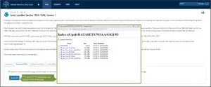
Once testing is complete, these functions will be extended to additional data sets. For data sets that are currently available via FTP or HTTPS, users will be able to view and click file lists without leaving the landing page:
These ongoing improvements are based on research and input from NSIDC data users. Feedback is welcome, via this link, or landing page Feedback icons.


