Summer’s waning light

As the sun dips lower on the horizon, air temperatures over the central Arctic Ocean are dropping to near freezing conditions. Further retreat of the ice cover will largely depend on ocean temperatures and wind patterns that can either compact the ice or spread it out. In the Antarctic, sea ice extent continues to track at record low values for this time of year.

Overview of conditions

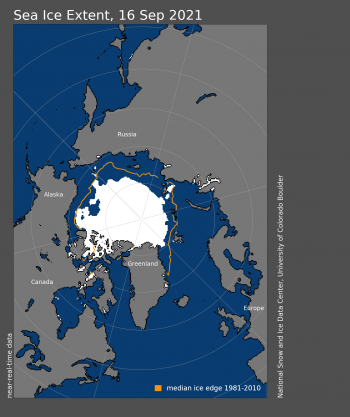
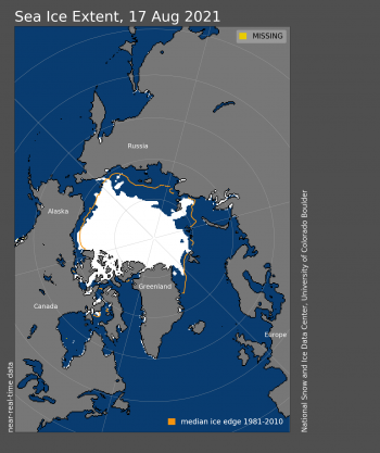
Figure 1. Arctic sea ice extent for XXXX XX, 20XX was X.XX million square kilometers (X.XX million square miles). The orange line shows the 1981 to 2010 average extent for that day. Sea Ice Index data. About the data||Credit: National Snow and Ice Data Center|High-resolution image

Figure 1a. Arctic sea ice extent for August 16, 2022 was 6.12 million square kilometers (2.36 million square miles). The orange line shows the 1981 to 2010 average extent for that day. Sea Ice Index data. About the data

Credit: National Snow and Ice Data Center
High-resolution image

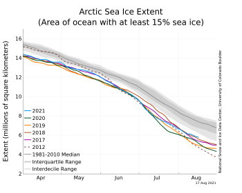
Figure 2. The graph above shows Arctic sea ice extent as of XXXXX XX, 20XX, along with daily ice extent data for four previous years and the record low year. 2021 is shown in blue, 2020 in green, 2019 in orange, 2018 in brown, 2017 in magenta, and 2012 in dashed brown. The 1981 to 2010 median is in dark gray. The gray areas around the median line show the interquartile and interdecile ranges of the data. Sea Ice Index data.||Credit: National Snow and Ice Data Center|High-resolution image

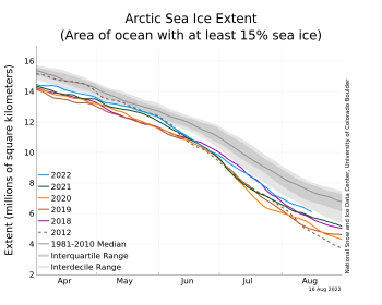
Figure 1b. The graph above shows Arctic sea ice extent as of August 16, 2022, along with daily ice extent data for four previous years and the record low year. 2022 is shown in blue, 2021 in green, 2020 in orange, 2019 in brown, 2018 in magenta, and 2012 in dashed brown. The 1981 to 2010 median is in dark gray. The gray areas around the median line show the interquartile and interdecile ranges of the data. Sea Ice Index data.

Credit: National Snow and Ice Data Center
High-resolution image

Figure 1b. This map shows Arctic sea ice concentration based on data from the Advanced Microwave Scanning Radiometer 2 (AMSR2) data. Yellows indicate sea ice concentration of 75 percent, dark purples indicate sea ice concentration of 100 percent. ||Credit: University of Bremen|High-resolution image

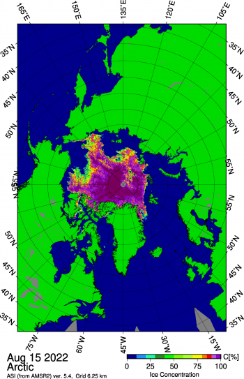
Figure 1c. This map shows Arctic sea ice concentration based on data from the Advanced Microwave Scanning Radiometer-2 (AMSR-2) data. Yellows indicate sea ice concentration of 75 percent, dark purples indicate sea ice concentration of 100 percent.

Credit: University of Bremen
High-resolution image

As of August 16, Arctic sea ice extent stood at 6.11 million square kilometers (2.36 square miles) (Figure 1a). This was similar to the total extent observed in 2008 and 2013 for this time of year, within 80,000 square kilometers (30,900 square miles) and 40,000 square kilometers (15,400 square miles), respectively. Extent was higher than all other years since 2007 except for 2009 and 2014 (Figure 1b). Since the beginning of August, the ice edge has remained relatively stable in the northern Barents and Kara Seas, with most of the ice retreating in the northern Chukchi Sea, the East Siberian Sea northwest of the New Siberian Islands, and within the channels of the Canadian Arctic Archipelago. Regionally, ice extent remains below the 1981 to 2010 average in the Barents, Kara, and Laptev Seas, and the northern part of the Chukchi Sea. Ice has persisted along the coast in the East Siberian Sea, where winds have pushed some of the multiyear ice against the shore. The southern route of the Northwest Passage through the Canadian Archipelago appears to be mostly free of ice according to sea ice concentrations from the Advanced Microwave Scanning Radiometer-2 (Figure 1c). However, the Canadian Ice Service reports some ice remains within Victoria Strait. For the first time since 2008, the Northern Sea Route along Eurasia may not become ice free.

While sea ice is overall more extensive than in recent summers, the ice pack is diffuse throughout the Beaufort Sea, the northern part of the Chukchi Sea, and within the East Siberian Sea. Polynyas have opened near 80 degrees N, north of the Kara Sea. With summer nearing its end, the surface of the ice in the central Arctic Ocean is beginning to refreeze. Any remaining loss of sea ice will be largely dominated by melting within the marginal ice zone by heat stored in the ocean. Ocean-driven melting can persist for another few weeks. The the regions of low ice concentration may still melt out. Wind patterns may also compact the ice in some regions and spread it out in others.

Conditions in context

Figure 2X. This plot shows the departure from average air temperature in the Arctic at the 925 hPa level, in degrees Celsius, for XXXmonthXX 20XX. Yellows and reds indicate higher than average temperatures; blues and purples indicate lower than average temperatures.||Credit: NSIDC courtesy NOAA Earth System Research Laboratory Physical Sciences Laboratory| High-resolution image

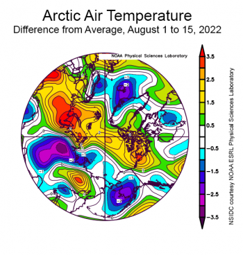
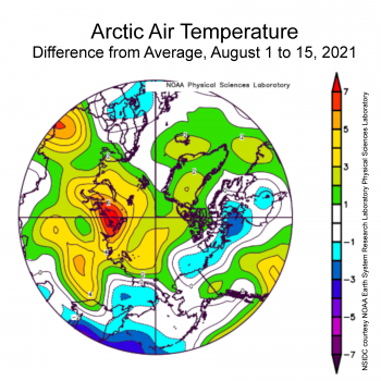
Figure 2. This plot shows the departure from average air temperature in the Arctic at the 925 hPa level, in degrees Celsius, from August 1 to 15, 2022. Yellows and reds indicate higher than average temperatures; blues and purples indicate lower than average temperatures.

Credit: NSIDC courtesy NOAA Earth System Research Laboratory Physical Sciences Laboratory
High-resolution image

During the first half of August, air temperatures at the 925 hPa level (about 2,500 feet above the surface) were modestly above average from the Beaufort Sea across the pole and towards the Kara and Barents Seas (Figure 2). By contrast, temperatures over parts of the East Siberian and Laptev Seas as well as the Bering Sea were slightly below average. While temperatures over the central Arctic Ocean were slightly above average, they are near the freezing point.

Seasonal melt onset a mixed bag

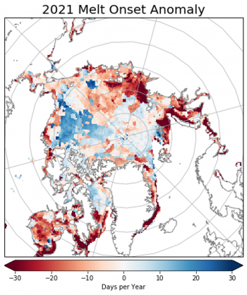
Figure 3. This map shows the date of sea ice melt onset in the Arctic for the 2021 melt season compared to the 1981 to 2010 average. Shades in red depict sea ice melt up to 30 days earlier than average, while shades in blue depict melt up to 30 days later than average. Credit: Walt Meier, NSIDC; data courtesy J. Miller, NASA Goddard High-resolution image

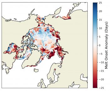
Figure 3. This map shows the date of sea ice melt onset in the Arctic for the 2021 melt season compared to the 1981 to 2010 average. Shades in red depict sea ice melt up to 30 days earlier than average, while shades in blue depict melt up to 30 days later than average.

Credit: Walt Meier, NSIDC; data courtesy J. Miller, NASA Goddard
High-resolution image

Melt onset began nearly a month earlier than the 1981 to 2010 average this year in the Kara and Barents Seas, Northern and Eastern Hudson Bay, and along the coast in the Laptev Sea. In the Bering Sea and the Sea of Okhotsk melt onset was between one and two weeks earlier than average. However, melt onset was later than average over most of the central Arctic Ocean and Baffin Bay. The timing of melt onset plays an important role in the ice-albedo feedback. Early melt onset darkens the surface and reduces its reflectivity, facilitating earlier development of melt ponds and open water areas that absorb more of the sun’s energy, hastening further melt. Early melt onset within the Laptev, Kara, and Barents Seas thus likely fostered faster retreat of the ice cover in those regions. Similarly, late melt onset in Baffin Bay and Davis Strait is consistent with a more extensive ice cover in this region early in the melt season.

Will the extent drop below 5 million square kilometers?

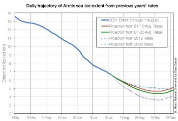
Figure 5. This figure shows Arctic sea ice extent projections for the 2021 minimum using data through August 1, 2021. The projections are based on the average loss rates for the 1981 to 2010 average in red, the 2007 to 2020 average in green, 2012 rates in dotted purple, and 2006 rates in dotted teal. ||Credit: Walt Meier, National Snow and Ice Data Center|High-resolution image

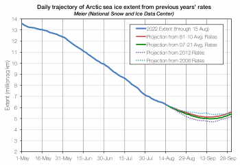
Figure 4. This figure shows Arctic sea ice extent projections for the 2022 minimum using data through August 15, 2022. The solid blue line depicts sea ice extent from May 1 to August 15, 2022. The projections are based on the average loss rates for the 1981 to 2010 average in red, the 2007 to 2021 average in green, 2012 rates in dotted purple, and 2006 rates in dotted teal. 2012 yields the lowest projected minimum, while 2006 yields the highest projected minimum. This figure has been submitted to the 2022 Sea Ice Outlook August report.

Credit: Walt Meier, National Snow and Ice Data Center
High-resolution image

One simple way to estimate how much ice will be left at the end of this summer is to use ice loss rates from previous years and apply them to this year. Starting on August 15 and forecasting 6 weeks into the future suggests a 30 percent chance the total extent this summer may stay above 5 million square kilometers (1.93 million square miles), something that has not happened since 2014. The fastest ice loss rates occurred in 2012, the year which ended up with the record minimum ice extent. With this unlikely trajectory, extent would bottom out at about 4 million square kilometers (1.54 million square miles). We expect that the September minimum ice extent will rank between the seventh and fifteenth lowest this year.

Antarctic sea ice still tracking at record lows

Figure 2. The graph above shows Arctic sea ice extent as of XXXXX XX, 20XX, along with daily ice extent data for four previous years and the record low year. 2021 is shown in blue, 2020 in green, 2019 in orange, 2018 in brown, 2017 in magenta, and 2012 in dashed brown. The 1981 to 2010 median is in dark gray. The gray areas around the median line show the interquartile and interdecile ranges of the data. Sea Ice Index data.||Credit: National Snow and Ice Data Center|High-resolution image

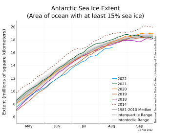
Figure 5. The graph above shows Antarctic sea ice extent as of August 16, 2022, along with daily ice extent data for four previous years and the record high year. 2022 is shown in blue, 2021 in green, 2020 in orange, 2019 in brown, 2018 in magenta, and 2014 in dashed brown. The 1981 to 2010 median is in dark gray. The gray areas around the median line show the interquartile and interdecile ranges of the data. Sea Ice Index data.

Credit: National Snow and Ice Data Center
High-resolution image

As of August 16, Antarctic sea ice extent was tracking below all previous years. At the start of August, it was tracking at second lowest. Ice retreated in the Bellingshausen Sea and parts of the Indian Ocean the first two weeks of August, whereas the ice edge expanded in the Weddell and Ross Seas. In the Bellingshausen Sea, air temperatures at the 925 millibar level have been as much as 7 degrees Celsius (13 degrees Fahrenheit) above average the first two weeks of August, as winds from the north have pushed warmer air and the ice edge towards the Antarctic coast.

A mid-summer night’s sea ice

Arctic sea ice extent continued its summer decline. Extent is below average but not as low as in recent summers. In the Antarctic, sea ice extent is currently at record low levels for this time of year.

Overview of conditions

Figure 1. Arctic sea ice extent for XXXX 20XX was X.XX million square kilometers (X.XX million square miles). The magenta line shows the 1981 to 2010 average extent for that month. Sea Ice Index data. About the data||Credit: National Snow and Ice Data Center|High-resolution image

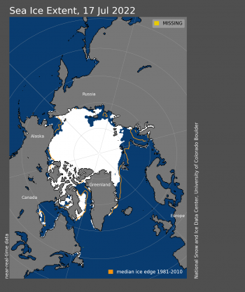
Figure 1a. Arctic sea ice extent for July 17, 2022, was 8.42 million square kilometers (3.25 million square miles). The orange line shows the 1981 to 2010 average extent for that day. Sea Ice Index data. About the data

Credit: National Snow and Ice Data Center
High-resolution image

Figure 2. The graph above shows Arctic sea ice extent as of XXXXX XX, 20XX, along with daily ice extent data for four previous years and the record low year. 2021 is shown in blue, 2020 in green, 2019 in orange, 2018 in brown, 2017 in magenta, and 2012 in dashed brown. The 1981 to 2010 median is in dark gray. The gray areas around the median line show the interquartile and interdecile ranges of the data. Sea Ice Index data.||Credit: National Snow and Ice Data Center|High-resolution image

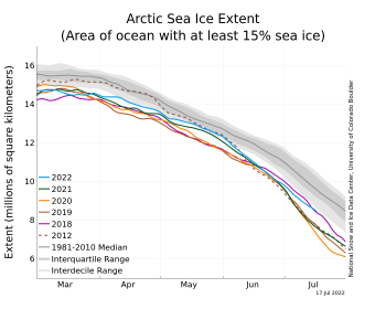
Figure 1b. The graph above shows Arctic sea ice extent as of July 17, 2022, along with daily ice extent data for four previous years and the record low year. 2022 is shown in blue, 2021 in green, 2020 in orange, 2019 in brown, 2018 in magenta, and 2012 in dashed brown. The 1981 to 2010 median is in dark gray. The gray areas around the median line show the interquartile and interdecile ranges of the data. Sea Ice Index data.

Credit: National Snow and Ice Data Center
High-resolution image

As of the middle of the Arctic summer, on July 17, sea ice extent was 8.42 million square kilometers (3.25 million square miles) (Figure 1a). The decline rate of the extent through the first half of July was near the 1981 to 2010 average. Extent on July 17 was the highest since 2015 and overall was thirteenth lowest in the satellite record (Figure 1b).

The most notable area of ice loss so far is in the Laptev Sea. This is similar to the pattern of the last two years, but much less extreme than observed in 2020 and 2021 when the Laptev Sea ice extent was at or near record low levels in June and July. Extent continues to be below average in the Barents Sea.

Conditions in context

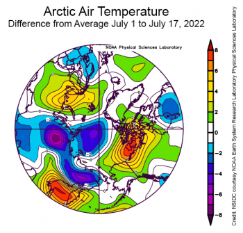
Figure 2b. This plot shows the departure from average air temperature, relative to the 1981 to 2020 reference period, in the Arctic at the 925 hPa level, in degrees Celsius, from July 1 to July 17, 2022. Yellows and reds indicate higher than average temperatures; blues and purples indicate lower than average temperatures.||Credit: NSIDC courtesy NOAA Earth System Research Laboratory Physical Sciences Laboratory| High-resolution image

Figure 2a. This plot shows the departure from average air temperature, relative to the 1981 to 2020 reference period, in the Arctic at the 925 hPa level, in degrees Celsius, from July 1 to July 17, 2022. Yellows and reds indicate higher than average temperatures; blues and purples indicate lower than average temperatures.

Credit: NSIDC courtesy NOAA Earth System Research Laboratory Physical Sciences Laboratory
High-resolution image

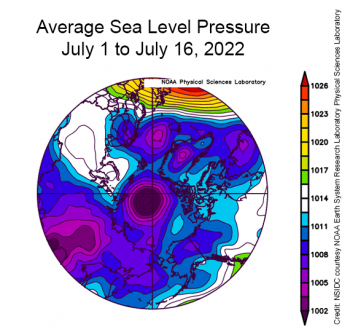
Figure 2X. This plot shows average sea level pressure in the Arctic in millibars for XXXmonthXX 20XX. Yellows and reds indicate high air pressure; blues and purples indicate low pressure.||Credit: NSIDC courtesy NOAA Earth System Research Laboratory Physical Sciences Laboratory| High-resolution image

Figure 2b. This plot shows average sea level pressure in the Arctic in millibars from July 1 to July 16, 2022. Yellows and reds indicate high air pressure; blues and purples indicate low pressure.

Credit: NSIDC courtesy NOAA Earth System Research Laboratory Physical Sciences Laboratory
High-resolution image

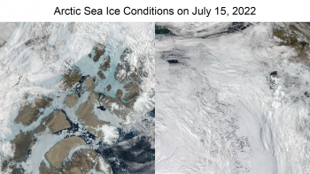
Figure 2d. This NASA WorldView image from the MODIS sensor shows sea ice conditions in the Canadian Archipelago on July 15, 2022. The left image shows melt ponds over sea ice as seen in light blue-green. The right image shows the low sea ice concentration in the Laptev and Kara Seas on the same day. ||Credit: NASA Worldview|High-resolution image

Figure 2c. These two NASA WorldView True Color images from the Moderate Resolution Imaging Spectroradiometer (MODIS) sensor show sea ice conditions in two regions of the Arctic on July 15, 2022. The left image shows melt ponds over sea ice, as seen in light blue-green, in the Canadian Arctic Archipelago. The right image shows the low sea ice concentration in the Laptev and Kara Seas towards the North Pole.

Credit: NASA Worldview
High-resolution image

In terms of air temperature, the first half of July 2022 was a tale of regional contrasts (Figure 2a). On the Eurasian side of the Arctic, particularly in the Laptev and Barents Seas, extending toward the North Pole, air temperatures at the 925 mb level (about 2,500 feet about the surface) were 3 to 6 degrees Celsius (5 to 11 degrees Fahrenheit) below average. On the North American side of the Arctic, air temperatures were as much as 8 degrees Celsius (14 degrees Fahrenheit) above average, notably in the southeast Beaufort Sea and the western Canadian Arctic  Archipelago. The sea level pressure pattern was dominated by low pressure over the Laptev Sea sector, centered near the North Pole (Figure 2b).

Warm conditions in the Canadian Arctic Archipelago have enhanced melt pond formation and evolution (Figure 2c, left). Also of note is a region of low concentration ice near the North Pole in the Laptev and Kara Seas sector (Figure 2c, right). Low pressure, such as has been centered over the region in early July, often results in divergence of the ice cover and likely helped form the low concentration area.

Low snow and heat waves

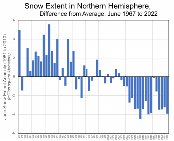
Figure X. This graph shows snow cover extent anomalies in the Northern Hemisphere for MONTH from XXXX to XXXX. The anomaly is relative to the 1981 to 2010 average.||Credit: National Snow and Ice Data Center, courtesy Rutgers University Global Snow Lab| High-resolution image

Figure 3. This graph shows snow cover extent as a difference from average in the Northern Hemisphere for June from 1967 to 2022. The anomaly is relative to the 1981 to 2010 average.

Credit: National Snow and Ice Data Center, courtesy Rutgers University Global Snow Lab
High-resolution image

By June, snow usually remains only in the high north above the Arctic Circle or at high elevations. June 2022 shows particularly low Northern-Hemisphere snow extent, indicating that the snow melt occurred faster than average. According to Rutgers Snow Lab data, the June 2022 Northern Hemisphere snow extent was third lowest in the record dating back to 1967; only 2012 and 2015 had lower June snow extent (Figure 3).

A recent paper by Rousi et al. found that changes in the jet stream are an important factor in promoting European heatwaves. A possible factor in the jet stream changes is the increasing coastal temperature contrast between the rapidly warming land surface and the more slowly warming ocean/sea ice surface. An early loss of snow contributes to the warming land surface because the loss of high albedo snow allows earlier and more rapid absorption of solar energy. Other studies have also linked early snow loss to summer mid-latitude heatwaves (e.g., Zhang et al., and Connolly et al.).

NASA summer airborne sea ice campaign

ICESat-2 provides estimates of sea ice freeboard (height above the waterline) and thickness.

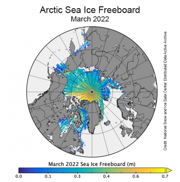
Figure 4. This map shows estimates of sea ice freeboard, or the height of sea ice above the waterline, for March 2022. Data are from the NASA Ice, Cloud, and land Elevation Satellite-2 (ICESat-2).

Credit: NASA National Snow and Ice Data Center Distributed Active Archive Center (NSIDC DAAC)
High-resolution image

NASA’s Ice, Cloud and land Elevation Satellite-2 (ICESat-2) laser altimeter, which launched in 2018, continues to perform well and is providing elevation data of vegetation, clouds, lakes, glaciers, ice sheets, and sea ice. The NASA Snow and Ice DAAC at NSIDC archives and distributes its data. ICESat-2 provides estimates of sea ice freeboard (height above the waterline) and thickness (Figure 4). During summer, when the ice surface is melting, the sea ice data from ICESat-2 have larger errors. NASA scientists are currently in the Arctic conducting an airborne campaign to collect a myriad of validation data that they hope will help improve the ICESat-2 estimates during summer.

Antarctic sea ice extent

Figure 2. The graph above shows Arctic sea ice extent as of XXXXX XX, 20XX, along with daily ice extent data for four previous years and the record low year. 2021 is shown in blue, 2020 in green, 2019 in orange, 2018 in brown, 2017 in magenta, and 2012 in dashed brown. The 1981 to 2010 median is in dark gray. The gray areas around the median line show the interquartile and interdecile ranges of the data. Sea Ice Index data.||Credit: National Snow and Ice Data Center|High-resolution image

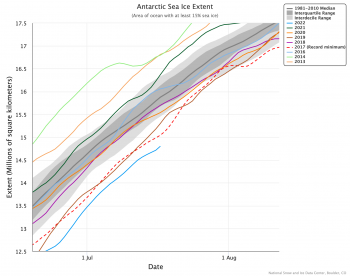
Figure 5. The graph above shows Antarctic sea ice extent as of July 17, 2022, along with daily ice extent data for seven previous years and the 2017 record low year. 2022 is shown in blue, 2021 in green, 2020 in orange, 2019 in brown, 2018 in magenta, 2016 in light blue, 2014 in light green, 2013 in light orange, and 2017 in dashed red. The 1981 to 2010 median is in dark gray. The gray areas around the median line show the interquartile and interdecile ranges of the data. Sea Ice Index data.

Credit: National Snow and Ice Data Center
High-resolution image

As of July 17, Antarctic sea ice extent was 14.80 million square kilometers (5.71 million square miles), roughly 240,000 square kilometers (92,700 square miles) below the previous record daily low set in 2017 and 1.14 million square kilometers (440,000 square miles) below the 1981 to 2010 average extent for July 17 (Figure 5). Nearly all regions of coastal Antarctica were below the average extent for mid-July, with the Amundsen and Bellingshausen Seas showing the largest deficits. Ice extent along the northern edge of the Weddell and Dronning Maud sectors, and the region near the Amery Ice Shelf, was also far below average. The polynya that appears in some years in the Cosmonaut Sea has returned. A few areas of the Ross Sea and Wilkes Land have near or slightly above average extent in the satellite record. Temperatures at the 925 millibar level are 3 to 6 degrees Celsius (5 to 11 degrees Fahrenheit) above average for a wide swath of the Antarctic Peninsula and West Antarctic coast, and the Weddell Sea ice edge region is 2 to 3 degrees Celsius (4 to 5 degrees Fahrenheit) above average, with the remaining coast near-average or slightly below.

References

Connolly, R., M. Connolly, W. Soon, D. R. Legates, R. G. Cionco, V. M. Velasco Herrera. 2019. Northern Hemisphere Snow-Cover Trends (1967–2018): A Comparison between Climate Models and Observations. Geosciences. 9(3):135. doi:10.3390/geosciences9030135.

Petty, A. A., R. Kwok, M. Bagnardi, A. Ivanoff, N. Kurtz, J. Lee, J. Wimert, and D. Hancock. 2021. ATLAS/ICESat-2 L3B Daily and Monthly Gridded Sea Ice Freeboard, Version 3. [March 2022]. Boulder, Colorado USA. NASA National Snow and Ice Data Center Distributed Active Archive Center. doi:10.5067/ATLAS/ATL20.003. [Accessed 14 Jul 2022].

Rousi, E., K. Kornhuber, G. Beobide-Arsuaga, and others. 2022. Accelerated western European heatwave trends linked to more-persistent double jets over Eurasia. Nature Communications. 13, 3851. doi:10.1038/s41467-022-31432-y.

Zhang, R., C. Sun, J. Zhu, R. Zhang, and W. Li. 2020. Increased European heat waves in recent decades in response to shrinking Arctic sea ice and Eurasian snow cover. Nature Partner Journals: Climate & Atmospheric Science. 3, 7. doi:10.1038/s41612-020-0110-8.

Clear solstice skies over the Arctic

Both of Earth’s polar regions had low sea ice extent for the month of June, with Antarctic sea ice setting a record low. Arctic sea ice extent stands at tenth lowest. Near-record low ice extent characterized the Barents and Hudson Bay areas, and there are several low-concentration regions in the Beaufort Sea, an area that usually has a dense ice pack at this time of year.

Overview of conditions

Figure 1. Arctic sea ice extent for XXXX 20XX was X.XX million square kilometers (X.XX million square miles). The magenta line shows the 1981 to 2010 average extent for that month. Sea Ice Index data. About the data||Credit: National Snow and Ice Data Center|High-resolution image

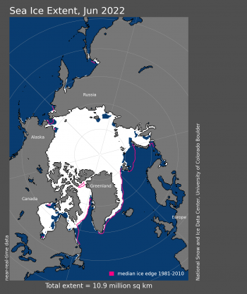
Figure 1. Arctic sea ice extent for June 2022 was 10.86 million square kilometers (4.19 million square miles). The magenta line shows the 1981 to 2010 average extent for that month. Sea Ice Index data. About the data

Credit: National Snow and Ice Data Center
High-resolution image

Average Arctic sea ice extent for June 2022 was 10.86 million square kilometers (4.19 million square miles), ranking tenth lowest in the satellite record (Figure 1). The 2022 June extent was 900,000 square kilometers (347,000 square miles) below the 1981 to 2010 average. Total ice loss for June was 2.50 million square kilometers (965,000 square miles). The Barents Sea is nearly ice free, with the ice edge far north of its usual location for this time of year. Hudson Bay is also losing ice unusually early. Extent in the Chukchi, East Siberian, and Kara Seas is slightly below average. The most notable feature along the Russian coast is the opening of a large polynya in the Laptev Sea near the New Siberian Islands. Baffin Bay has near average ice extent, and in early June the North Water Polynya opened. Some extensive low-ice-concentration regions are forming over the central Arctic Ocean, perhaps portending large polynyas in the later part of the summer.

Conditions in context

Figure 2. The graph above shows Arctic sea ice extent as of XXXXX XX, 20XX, along with daily ice extent data for four previous years and the record low year. 2021 is shown in blue, 2020 in green, 2019 in orange, 2018 in brown, 2017 in magenta, and 2012 in dashed brown. The 1981 to 2010 median is in dark gray. The gray areas around the median line show the interquartile and interdecile ranges of the data. Sea Ice Index data.||Credit: National Snow and Ice Data Center|High-resolution image

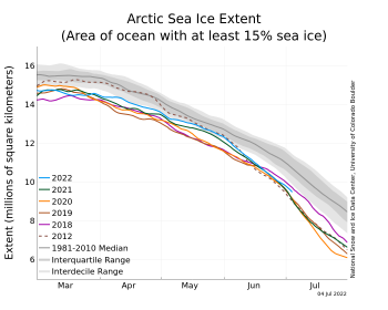
Figure 2a. The graph above shows Arctic sea ice extent as of July 4, 2022, along with daily ice extent data for four previous years and the record low year. 2022 is shown in blue, 2021 in green, 2020 in orange, 2019 in brown, 2018 in magenta, and 2012 in dashed brown. The 1981 to 2010 median is in dark gray. The gray areas around the median line show the interquartile and interdecile ranges of the data. Sea Ice Index data.

Credit: National Snow and Ice Data Center
High-resolution image

Figure 2X. This plot shows the departure from average air temperature in the Arctic at the 925 hPa level, in degrees Celsius, for XXXmonthXX 20XX. Yellows and reds indicate higher than average temperatures; blues and purples indicate lower than average temperatures.||Credit: NSIDC courtesy NOAA Earth System Research Laboratory Physical Sciences Laboratory| High-resolution image This plot shows average sea level pressure in the Arctic in millibars for XXXmonthXX 20XX. Yellows and reds indicate high air pressure; blues and purples indicate low pressure.||Credit: NSIDC courtesy NOAA Earth System Research Laboratory Physical Sciences Laboratory| High-resolution image

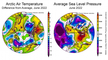
Figure 2b. The left plot shows the departure from average air temperature in the Arctic at the 925 hPa level, in degrees Celsius, for June 2022. Yellows and reds indicate higher than average temperatures; blues and purples indicate lower than average temperatures. The plot on the right shows average sea level pressure in the Arctic in millibars for June 2022. Yellows and reds indicate high air pressure; blues and purples indicate low pressure.

Credit: NSIDC courtesy NOAA Earth System Research Laboratory Physical Sciences Laboratory
High-resolution image

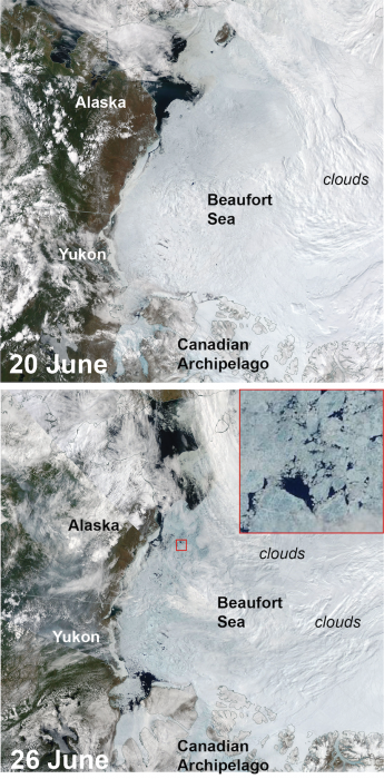
Figure 2c. These Moderate Resolution Imaging Spectroradiometer MODIS images from the Terra satellite of the Beaufort Sea and surrounding areas on June 20th (top) and June 26th (bottom). Blue tint over the sea ice areas not covered by clouds indicates rapid development of melt ponds on the ice. Inset, close-up of the area shown in the small red box on the 26 June image showing melt ponds on sea ice floes.

Figure 2c. These Moderate Resolution Imaging Spectroradiometer (MODIS) images from the NASA Terra satellite show the Beaufort Sea and surrounding areas on June 20 (top) and June 26 (bottom). Blue tint over the sea ice areas not covered by clouds indicates development of melt ponds on the ice. The inset is a closeup of the area in the small red box on the June 26 image, depicting melt ponds on sea ice floes.

Credit: NASA WorldView
High-resolution image

June air temperatures over the Arctic as assessed at the 925 hPa level (approximately 2,500 feet above the surface) were close to the long-term average. Most of the high-latitude Arctic Ocean was within a degree of the 1981 to 2010 average temperature. Temperatures in Scandinavia, Svalbard, and northern European Russia were generally 2 to 3 degrees Celsius (4 to 5 degrees Fahrenheit) above average (Figure 2b). The Hudson Bay region is also warm with temperatures 4 to 5 degrees Celsius (7 to 9 degrees Fahrenheit) above average. By contrast, temperatures over central Greenland, the northern Yukon and North Slope, and easternmost Siberia are all 2 to 4 degrees Celsius (4 to 7 degrees Fahrenheit) below average.

The June sea level pressure pattern was characterized by strong high pressure over the Beaufort Sea and a large low pressure area near Iceland (Figure 2b). This pattern is consistent with the warmth over Scandinavia and relatively cool conditions over Baffin Bay. A broad area of low pressure also dominates northwestern Eurasia. The strong high pressure over the Beaufort Sea, and generally high pressures over much of the Arctic Ocean, is consistent with a prevalence of clear skies. Since June is the month of the solstice, with the highest sun elevation, the clear skies let more solar energy reach the ice surface, leading to strong surface melting. Between June 20 and June 26, a large area of the Beaufort Sea started to show the development of melt ponds (Figure 2c).

June 2022 compared to previous years

Figure 3. Monthly XXXXX ice extent for 1979 to 20XX shows a decline of X.X percent per decade.||Credit: National Snow and Ice Data Center| High-resolution image

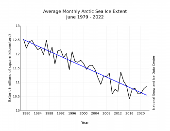
Figure 3. Monthly June ice extent for 1979 to 2022 shows a decline of 3.9 percent per decade.

Credit: National Snow and Ice Data Center
High-resolution image

The downward linear trend in June sea ice extent over the 44-year satellite record is 45,700 square kilometers (17,600 square miles) per year, or 3.9 percent per decade relative to the 1981 to 2010 average. Based on the linear trend, since 1979, June has lost 1.97 million square kilometers (761,000 square miles) of sea ice. This is equivalent to about three times the size of Texas.

Antarctic sea ice extent in June

Figure 1. Arctic sea ice extent for May 2022 was 12.88 million square kilometers (4.97 million square miles). The magenta line shows the 1981 to 2010 average extent for that month. Sea Ice Index data. About the data Credit: National Snow and Ice Data Center High-resolution image

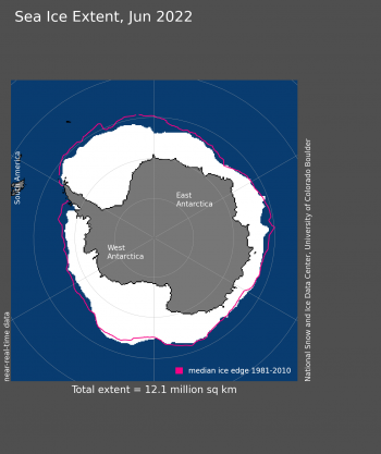
Figure 4. Antarctic sea ice extent for May 2022 was 12.1 million square kilometers (4.67 million square miles). The magenta line shows the 1981 to 2010 average extent for that month. Sea Ice Index data. About the data

Credit: National Snow and Ice Data Center
High-resolution image

Sea ice surrounding the Antarctic continent dipped to near-record low extent in late May and remained close to a record low through mid-month, setting a new record low starting on June 20. Sea ice growth was slower than average, particularly for the Bellingshausen and eastern Weddell seas (Figure 4). The Ross Sea and the sector north of Wilkes Land had near-average extent for the month. Antarctica’s air temperatures for the month at the 925 mb level were above average across nearly the entire continent and surrounding ocean. Over the Weddell Sea, air temperatures were 3 to 6 degrees Celsius (5 to 11 degrees Fahrenheit) above the 1981 to 2010 average, and over coastal areas of Wilkes Land, up to 4 degrees Celsius (7 degrees Fahrenheit) above average. Slightly below average temperatures prevailed over the eastern Ross Sea and western Amundsen Sea. Sea level pressure was low over the Bellingshausen Sea and high over the western Ross Sea. While wind directions based on the air pressure patterns are consistent with the temperature differences (cool winds come off the continent, warmer winds come from the north), in general they are not consistent with the sea ice pattern. Despite cool continental air flowing over the Amundsen Sea, sea ice extent is still low there; warm conditions along the Wilkes coast did not act to reduce June ice extent in that area.

“Atlantification” of the Barents Sea

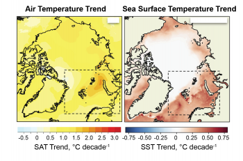
Figure X. Surface air temperature trend (left) and sea surface temperature (right) for the Barents Sea for 1981-2020. Data for surface air temperature are from the ERA-5 reanalysis; data for the sea surface temperature are from European Space Agency sources. Adapted from Isaksen et al. 2022.

Figure 5. The left map depicts the surface air temperature trend for the Barents Sea from 1981 to 2020. The map on the right depicts sea surface temperature for the same region. Data for surface air temperature are from the European Centre for Medium-Range Weather Forecasts (ECMWF) Reanalysis v5 (ERA-5); data for the sea surface temperature are from European Space Agency sources.

Credit: Adapted from Isaksen et al. 2022
High-resolution image

The Barents Sea has had persistently low winter sea ice extent for many years now. As a result of the more open ocean conditions, the trend in air temperature in the region is extreme: up to ten times the global trend in warming (Figure 5). This was highlighted in a recent study by Isaksen and others. Sea ice acts as a lid in autumn and winter, separating the fairly warm open ocean, which is just above freezing, from the cold Arctic air. Removing the ice results in a large transfer of heat from the ocean to the atmosphere, and therefore atmospheric warming.

The deeper issue is why the sea ice in the northern Barents Sea is declining, and it may be related to the “Atlantification” of the Arctic Ocean. Warm and salty Atlantic water enters the Arctic Ocean through the Barents Sea and eastern Fram Strait, and dives beneath the cold, relatively fresh and less dense surface layer of the Arctic Ocean. Previous research has shown that the fresh surface layer is thinning as a result of less summer sea ice, allowing heat from the Atlantic water to reach the surface, preventing winter sea ice from forming in the Barents Sea region. In short, some parts of the Barents Sea have started to resemble the Atlantic.

Strong La Niña in the Pacific

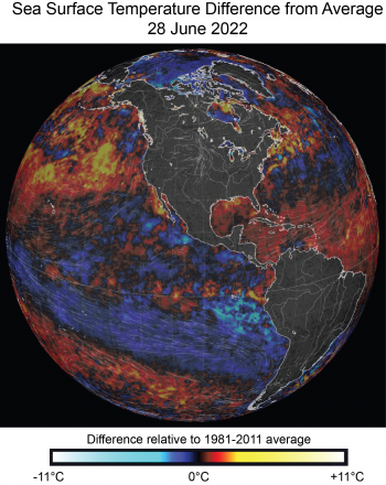
Figure Y. Image of sea surface temperature in the Western Hemisphere for 28 June, 2022 of sea surface temperature difference from average (relative to 1981-2010) from the nullschool.net website, showing the strong La Niña (blueish area in the equatorial Pacific) and the warm sea surface conditions in the northern Pacific.

Figure 6. This image shows sea surface temperature as a difference from average (relative to 1981 to 2010) in the Western Hemisphere for June 28, 2022. The blueish area in the equatorial Pacific depicts the strong La Niña conditions. Warm colors indicate warm sea surface conditions in the northern Pacific.

Credit: nullschool.net
High-resolution image

Oscillations in sea surface temperature in the equatorial Pacific, characterized by El Niño and La Niña conditions, can have widespread influences on atmospheric circulation patterns. Beginning around July 2020, a moderate La Niña pattern developed, characterized by a large pool of relatively cool water in the eastern tropical Pacific. This event has persisted with a brief hiatus in the summer of 2021. It is forecast to last through the end of the year, with some variations, generally weakening as the year progresses. Along with the La Niña pattern, a pool of unusually warm water has formed in the northern Pacific.

Researchers Jeong and others present evidence that La Niña events favor extensive Arctic sea ice retreat just north of the Pacific, including the East Siberian Sea, Chukchi Sea, and western Beaufort Sea, in part as a result of warm ocean conditions in the northern Pacific, as we are seeing this year. However, the air pressure pattern in June is unlike past La Niña events that led to rapid ice loss like in the 2012 summer, which set a satellite-era record low September sea ice minimum. That year had warm air and high pressure extending over Greenland, and a strong low pressure over the Siberian and Pacific Arctic that drove ice out of the Arctic Ocean through Fram Strait. At this time, sea ice loss in the Pacific side of the Arctic is moderate, but the large area of low sea ice concentration may grow rapidly in July and August.

Further reading and references

Jeong, H., H. S. Park, M. F. Stuecker, and S. W. Yeh. 2022. Record low Arctic sea ice extent in 2012 linked to two‐year La Niña‐driven sea surface temperature pattern. Geophysical Research Letters, p.e2022GL098385. doi:10.1029/2022GL098385

Isaksen, K., Ø.Nordli, B. Ivanov, et al. 2022. Exceptional warming over the Barents area. Scientific Reports 12, 9371. doi:10.1038/s41598-022-13568-5

Spring in fits and starts

After reaching its seasonal maximum extent of 14.88 million square kilometers (5.75 million square miles) on February 25, the seasonal decline in Arctic sea ice extent through March proceeded in fits and starts. By the end of the month, extent saw little change, ending up at 14.50 million square kilometers (5.60 million square miles). The middle of March saw excitement, with several extreme warm events over the Arctic Ocean associated with large transports of water vapor into the region. The Antarctic region also experienced unusual warmth and break up of a small ice shelf.

Overview of conditions

Arctic sea ice extent for March 2022

Figure 1. Arctic sea ice extent for March 2022 was 14.59 million square kilometers (5.63 million square miles). The magenta line shows the 1981 to 2010 average extent for that month. Sea Ice Index data. About the data

Credit: National Snow and Ice Data Center
High-resolution image

Average Arctic sea ice extent for March 2022 was 14.59 million square kilometers (5.63 million square miles), ranking ninth lowest in the satellite record (Figure 1a). The 2022 March extent was 840,000 square kilometers (324,000 square miles) below the 1981 to 2010 average. While extent tracked below the interdecile range of the satellite record throughout the entire month, the total decline, after a series of small ups and downs, was only 250,000 square kilometers (96,500 square miles). Following the pattern seen in February, sea ice extent was below average in the Sea of Okhotsk. Extent in the Bering, Barents, and East Greenland Seas was near average for March.

Conditions in context

Figure 2a. The graph above shows Arctic sea ice extent as of April 3, 2022, along with daily ice extent data for four previous years and the record low year. 2021 to 2022 is shown in blue, 2020 to 2021 in green, 2019 to 2020 in orange, 2018 to 2019 in brown, 2017 to 2018 in magenta, and 2011 to 2012 in dashed brown. The 1981 to 2010 median is in dark gray. The gray areas around the median line show the interquartile and interdecile ranges of the data. Sea Ice Index data.||Credit: National Snow and Ice Data Center|High-resolution image

Figure 2a. The graph above shows Arctic sea ice extent as of April 4, 2022, along with daily ice extent data for four previous years and the record low year. 2021 to 2022 is shown in blue, 2020 to 2021 in green, 2019 to 2020 in orange, 2018 to 2019 in brown, 2017 to 2018 in magenta, and 2011 to 2012 in dashed brown. The 1981 to 2010 median is in dark gray. The gray areas around the median line show the interquartile and interdecile ranges of the data. Sea Ice Index data.

Credit: National Snow and Ice Data Center
High-resolution image

Average Air Temperature for March 2022 in Arctic as a difference from average

Figure 2b. This plot shows the departure from average air temperature in the Arctic at the 925 hPa level, in degrees Celsius, for March 2022. Yellows and reds indicate higher than average temperatures; blues and purples indicate lower than average temperatures.

Credit: NSIDC courtesy NOAA Earth System Research Laboratory Physical Sciences Laboratory
High-resolution image

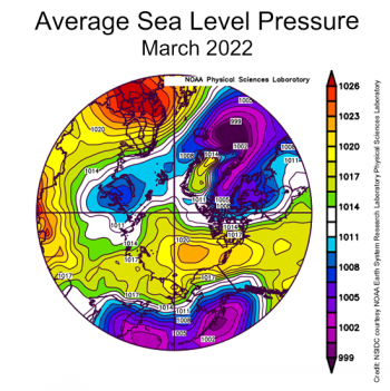
Average sea level pressure over Arctic for March 2022

Figure 2c. This plot shows average sea level pressure in the Arctic in millibars for March 2022. Yellows and reds indicate high air pressure; blues and purples indicate low pressure.

Credit: NSIDC courtesy NOAA Earth System Research Laboratory Physical Sciences Laboratory
High-resolution image

Counter to what might be expected given the very slow rate of sea ice loss over the month as a whole, air temperatures at the 925 millibar level (about 2,500 feet above the surface) were above average over all of the Arctic Ocean (Figure 2b). March temperatures were up to 9 degrees Celsius (16 degrees Fahrenheit) higher than average north of the Canadian Arctic Archipelago, up to 6 degrees Celsius (11 degrees Fahrenheit) above average in the East Siberian Sea, but up to 5 degrees Celsius (9 degrees Fahrenheit) above average over a wide area. The key features of the sea level pressure pattern were high pressure (an anticyclone) over the central Arctic Ocean, a trough of low pressure extending into the Barents Sea, and an unusually high pressure over Northern Europe (Figure 2c). While having an anticyclone over the central Arctic Ocean is quite typical for this time of year, the combination of the high pressure over northern Europe and the pressure trough to the west led to a strong pressure gradient, leading to strong winds from south through the Norwegian and Barents Seas. As discussed below, this can be tied to the extreme warm event over the Arctic Ocean seen in the middle of the month, associated with strong water vapor transport and the passage of several strong cyclones.

March 2022 compared to previous years

Arctic sea ice extent downward trend 1979 to 2022 for March

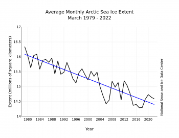
Figure 3. Monthly March ice extent for 1979 to 2022 shows a decline of 2.5 percent per decade.

Credit: National Snow and Ice Data Center
High-resolution image

The downward linear trend in March sea ice extent over the 44-year-satellite record is 39,200 square kilometers (15,100 square miles) per year, or 2.5 percent per decade relative to the 1981 to 2010 average. Based on the linear trend, since 1979, March has seen a loss of 1.74 million square kilometers (672,000 square miles). This is equivalent to about the size of Alaska.

Extreme events

animation of water transport near Greenland

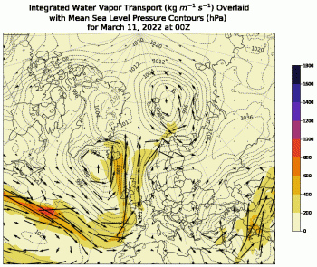
Figure 4a. Click on the figure to view the animation of sea level pressure and integrated vapor transport (IVT) near the Greenland Sea. The animation runs from March 11, 2022, through March 17, 2022. Arrows indicate direction and magnitude of transport, while shading indicates the magnitude of the water vapor transport.

Credit: Jessica Voveris, University of Colorado Boulder
High-resolution image

two map images of sea ice concentration east of Greenland before and after atmospheric river event

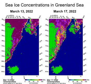
Figure 4b. These maps show sea ice concentration off the eastern coast of Greenland in the Greenland Sea. The map on the left shows sea ice on March 13, 2022, prior to the atmospheric river event passing through. The map on the right is after the event past on March 17, 2022.

Credit: Gunnar Spreen, University of Bremen
High-resolution image

On March 14, air temperatures at the 925 hPa level northwest of Greenland were up to 15 degrees Celsius (27 degrees Fahrenheit) above average. This was part of a series of warm pulses of air moving into the Arctic Ocean from the northern North Atlantic. For example, on March 17, temperatures over the Kara Sea reached 15 degrees Celsius (27 degrees Fahrenheit) above average. Quite often, such warm events are tied to strong transport of water vapor and associated cloud cover. In the animation (Figure 4a-click to view), arrows indicate the direction and magnitude of the integrated vapor transport (IVT) along with sea level pressure from March 11 through March 17, 2022. The shading indicates the magnitude of the transport. Several periods of very strong vapor transport from the northern North Atlantic directly into the Arctic Ocean occurred mid-month; this is consistent with the pattern of strong surface winds from the south through the Norwegian and Barents Seas as implied by the monthly averaged sea level pressure field (Figure 2c). The periods of strong vapor transport are linked to the passage of cyclones (low pressure systems) into the Arctic Ocean. While further analysis is needed, the narrow ribbons of strong water vapor transport into the Arctic Ocean appears to be linked to what are known as atmospheric rivers, which can carry an amount of water vapor far in excess of the discharge of the Mississippi River at its mouth. Atmospheric rivers form in the warm subtropics. The atmospheric circulation pulls the water vapor and forms a narrow band that can be thousands of miles long. When atmospheric rivers reach a coast or flow inland over mountains, the moist air is forced upwards, the water vapor condenses, and heavy precipitation may fall as rain or snow.

There is also evidence, presented at the Arctic Science Summit Week by colleague Gunnar Spreen of the University of Bremen, that the cyclones associated with the strong vapor transport churned up the sea ice in the East Greenland Seas (Figure 4b). Ice concentrations from the University of Bremen AMSR2 product show lower ice concentrations on March 17 compared to March 13 as the passing cyclone broke up ice cover. The result was reduced sea ice concentration and the opening up of numerous leads in the area.

A further look at the Endurance using NSIDC’s Sea Ice Tracking Utility

Drift potential trajectories for the Endurance

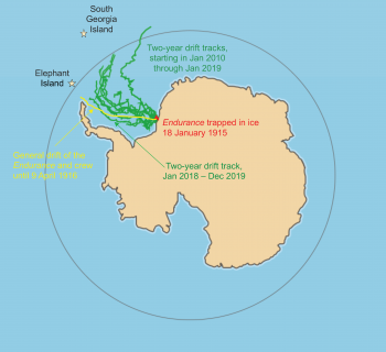
Figure 5. This map shows ice drift trajectories from January 2010 (green) using NSIDC’s Sea Ice Tracking Utility (SITU) tool. Each track encompasses a two-year period. The drift trajectories are based on observations over the last 40 years or more. The left-most track, for January 2018 through December 2019, follows the actual drift (yellow) of the Endurance in January 1915 to April 1916, but the recent drift tracks are considerably slower. The positions of Elephant Island, where the crew rowed to after leaving the ice, and South Georgia Island, where Shackleton and five others were eventually able to reach civilization, are denoted by stars.

Credit: Walt Meier, NSIDC
High-resolution image

As mentioned in last month’s post, the wreck of the Endurance was found on the floor of the Weddell Sea. The Endurance became trapped in the ice on January 18, 1915, at 76.57 degrees South latitude and 328.5 degrees East longitude. It drifted with the ice over the ensuing months until the ice closed in and began crushing the ship in October. The crew abandoned ship on October 27, 1915, and the Endurance finally sank on November 21, 1915, at 68.64 degrees South latitude, 53.0 West longitude. The crew camped and drifted with the ice until the ice began to break up. They launched lifeboats on April 9, 1916. Fortunately, they were close enough to row to the small uninhabited Elephant Island that at least provided some shelter. Expedition leader Earnest Shackleton and five others then sailed by lifeboat to South Georgia Island, several hundred miles away. After landing, they had to cross by foot over a mountain chain before finally reaching a whaling station. They were eventually able to secure a rescue ship to the rest of the crew on Elephant Island. All crew members were saved.

While the leadership of Earnest Shackleton and the fortitude of the crew where essential to their rescue, they were also fortunate in that the ice drift brought them west as well as north, putting them in proximity of islands off of the Antarctic Peninsula. NSIDC’s Sea Ice Tracking Utility (SITU) is a tool that allows us to investigate the drift of the ice based on observations over the last 40 or more years. The tool was developed at NSIDC in collaboration with colleagues Stephanie Pfirman (Arizona State University), Bruno Tremblay (McGill University), and Bob Newton (Columbia University). We can examine whether the drift of Shackleton’s ship was a common or rare occurrence using the SITU record. It appears that the drift of the Endurance was rare within the observational record. Starting from the location for the Endurance’s wreck, only one of the drift tracks in the SITU record, from January 2018 through December 2020, would have taken the crew so far north and west—toward the potential haven of Elephant Island. Other SITU tracks would have taken the crew further from land and toward the open ocean. Additionally, the drift of the Shackleton crew was particularly fast—they came out of the ice within about 14 months. The observed drift from 1979 through 2020 in SITU would keep them in the ice for at least two years. This means that the crew would not have been able to get to Elephant Island in late spring but would have had to winter over on the ice, possibly for several more months.

Strong warming event brings record-setting temperatures to East Antarctica

Figure 6. These weather maps show the heat wave event of March 16 to 18 in Antarctica. Map (a) shows temperature difference from average for the date; map (b) shows wind pattern at 500 millibar (about 18,000 feet) showing the far southern excursion of the westerly wind belt over Wilkes Land and far up onto the East Antarctic Plateau; and map (c) shows an image of water vapor content for 16:00 Coordinated Universal Time (UTC) on March 16 when the atmospheric river of water vapor flows onto the East Antarctic coast. ||Credit: University of Maine, National Oceanic and Atmospheric Administration | High-resolution image

Figure 6a. These weather maps show the heat wave event of March 16 to 18 in Antarctica. Map (a) shows temperature difference from average for the date; map (b) shows wind pattern at 500 millibar (about 18,000 feet) showing the far southern excursion of the westerly wind belt over Wilkes Land and far up onto the East Antarctic Plateau.

Credit: University of Maine, National Oceanic and Atmospheric Administration (NOAA)
High-resolution image

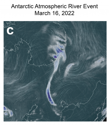
Figure 6b. These weather maps shows the atmospheric river event over Antarctica on March 16, 2022. As of 16:00 Coordinated Universal Time (UTC) the atmospheric river of water vapor flows onto the East Antarctic coast. ||Credit: University of Maine, National Oceanic and Atmospheric Administration | High-resolution image

Figure 6b. This weather map shows the atmospheric river event over Antarctica on March 16, 2022. At 16:00 Coordinated Universal Time (UTC) the atmospheric river of water vapor flowed onto the East Antarctic coast.

Credit: University of Maine, National Oceanic and Atmospheric Administration (NOAA)
High-resolution image

Between March 16 and 18, a combination of an unusual high-pressure region southeast of New Zealand and a strong low pressure south of Perth, Australia, led to a pulse of warm and moist air from east Australia (the Tasman Sea) to the Antarctic coastline and up onto the East Antarctic Plateau (Figure 6a). As the pulse of air, another example of what appears to be an atmospheric river, reached the coast, sustained periods of above-freezing temperatures and rain were observed at the coastal bases (Figure 6b). Air temperatures at Casey and Dumont D’Urville Stations, were above freezing for nearly two days at 6 degrees Celsius (43 degrees Fahrenheit) and 4 degrees Celsius (39 degrees Fahrenheit), respectively. Because of the high moisture content of the air mass, temperatures remained high as the air climbed onto the ice sheet. Precipitation, and the heat released by condensation of moisture, kept the air warm as it moved up onto the plateau, bringing temperatures far above those typical for mid-March. Temperatures at high-elevation stations such as Russia’s Vostok Station and the European station at Dome Concordia, were more than 35 degrees Celsius (63 degrees Fahrenheit) above average for this time of year.

Ice shelf in eastern Wilkes Land breaks up

Worldview images of Conger Ice Shelf before and after collapse

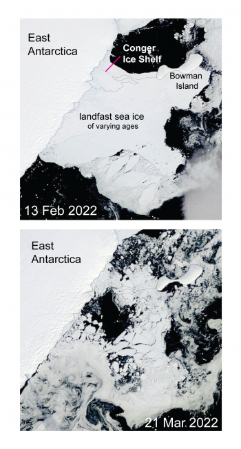
Figure 7. These images from the Moderate Resolution Imaging Spectroradiometer (MODIS) instrument on the NASA Terra Satellite show the before and after details of the Conger Ice Shelf break up. Images are 188 kilometers (117 miles) on a side, north is to the lower right. Conger Ice Shelf is near 66 degrees South, 103 degrees East longitude.

Credit: NASA Worldview
High-resolution image

After many years of rifting and small calvings, the Conger Ice Shelf, at the eastern end of the Wilkes Land coast and just east of the Shackleton Ice Shelf, has calved into several large pieces and two named icebergs, C-37 and C-38. The ice shelf was about 1,200 square kilometers (463 square miles) in area towards the end but had been losing area over several years. The flow of the glacier pushed the ice shelf front against a small island, Bowman Island, just off the coast of Antarctica. The stress of the floating ice shelf being pushed against the snow-covered rock island caused large rifts to form and eventually forced pieces to break away. This is an example of what happens when a strong force (continental ice sheet flow) impinges on an immovable object (a rocky island). The event does not appear to be directly related to the recent record low sea ice extent in Antarctica, or the recent heat wave. In fact, the break up occurred just before the warm event.

Reference

Campbell, G. G., S. Pfirman, B. Tremblay, R. Newton, P. DeRepentigny, W. Meier, and C. Fowler. The Ice Tracker. http://icemotion.labs.nsidc.org/SITU

Arctic sea ice maximum at tenth lowest in satellite record

Arctic sea ice has likely reached its maximum extent for the year, at 14.88 million square kilometers (5.75 million square miles) on February 25. The 2022 maximum is the tenth lowest in the 44-year satellite record. On the same day, on the other pole, Antarctic sea ice reached a record minimum extent, at 1.92 million square kilometers (741,000 square miles).

Overview of conditions

Feb 25, 2022 sea ice extent maximum on map

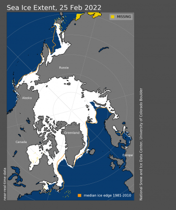
Figure 1. Arctic sea ice extent for February 25, 2022, was 14.88 million square kilometers (5.75 million square miles). The orange line shows the 1981 to 2010 average extent for that day. Sea Ice Index data. About the data

Credit: National Snow and Ice Data Center
High-resolution image

On February 25, 2022, Arctic sea ice likely reached its maximum extent for the year, at 14.88 million square kilometers (5.75 million square miles), the tenth lowest extent in the satellite record. This year’s maximum extent is 770,000 square kilometers (297,000 square miles) below the 1981 to 2010 average maximum of 15.65 million square kilometers (6.04 million square miles) and 470,000 square kilometers (182,000 square miles) above the lowest maximum of 14.41 million square kilometers (5.56 million square miles) set on March 7, 2017. Prior to 2019, the four lowest maximum extents occurred from 2015 to 2018.

The date of the maximum this year, February 25, was fifteen days earlier than the 1981 to 2010 average date of March 12. Only two years had an earlier maximum, 1987 and 1996, both on February 24. This year is the second earliest date on the satellite record, tying with 2015, which also reached its maximum extent on February 25.

Conditions in context

Figure 2. The graph above shows Arctic sea ice extent as of XXXXX XX, 20XX, along with daily ice extent data for four previous years and the record low year. 2020 to 2021 is shown in blue, 2019 to 2020 in green, 2018 to 2019 in orange, 2017 to 2018 in brown, 2016 to 2017 in magenta, and 2012 to 2013 in dashed brown. The 1981 to 2010 median is in dark gray. The gray areas around the median line show the interquartile and interdecile ranges of the data. Sea Ice Index data.||Credit: National Snow and Ice Data Center|High-resolution image

Figure 2. The graph above shows Arctic sea ice extent on February 25, 2022, along with daily ice extent data for four previous years and the record low year. 2021 to 2022 is shown in blue, 2020 to 2021 in green, 2019 to 2020 in orange, 2018 to 2019 in brown, 2017 to 2018 in magenta, and 2012 to 2013 in dashed brown. The 1981 to 2010 median is in dark gray. The gray areas around the median line show the interquartile and interdecile ranges of the data. Sea Ice Index data.

Credit: National Snow and Ice Data Center
High-resolution image

The ice growth season ended with near average sea ice extent in the Bering Sea, above average in Baffin Bay and off the coast of south-eastern Greenland, and below average in the Barents Sea with a narrow open-water wedge north of Novaya Zemlya. Extent was well below average in the Gulf of St. Lawrence and the Sea of Okhotsk.

Since the maximum on February 25, extent has dropped about 390,000 square kilometers (151,000 square miles), with losses primarily in the Sea of Okhotsk and the Barents Sea. These losses have been offset by gains in the Bering Sea, Baffin Bay, and the Labrador Sea.

Table 1. Ten lowest maximum Arctic sea ice extents (satellite record, 1979 to present)

Rank Year In millions of square kilometers In millions of square miles Date
1 2017 14.41 5.56 March 7
2 2018 14.47 5.59 March 17
3 2016
2015
14.51
14.52
5.60
5.61
March 23
February 25
5 2011
2006
14.67
14.68
5.66
5.67
March 9
March 12
7 2007
2021
14.77
14.77
5.70
5.70
March 12
March 21
9 2019 14.82 5.72 March 13
10 2022 14.88 5.75 February 25

For the Arctic maximum, which typically occurs in March, the uncertainty range is ~34,000 square kilometers (13,000 square miles), meaning that extents within this range must be considered effectively equal.

The Antarctic minimum

Antarctic sea ice minimum extent on Feb 25, 2022

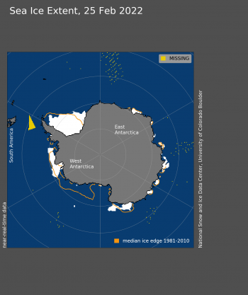
Figure 3. Antarctic sea ice extent for February 25, 2022, was 1.92 million square kilometers (741,000 square miles). The orange line shows the 1981 to 2010 average extent for that day. Sea Ice Index data. About the data

Credit: National Snow and Ice Data Center
High-resolution image

As noted in our previous post, in the Southern Hemisphere, sea ice reached its record minimum extent for the year on the same day, February 25. For the first time in the satellite record, which began in 1979, extent fell below 2 million square kilometers (772,000 square miles) at 1.92 million square kilometers (741,000 square miles). This year’s minimum extent was 190,000 square kilometers (73,400 square miles) below the previous record set on March 3, 2017. The Antarctic minimum extent is 930,000 square kilometers (359,000 square miles) below the 1981 to 2010 average minimum of 2.85 million square kilometers (1.10 million square miles).

The February 25 timing of the minimum was only a day later than the 1981 to 2010 median date of February 24 for the minimum. Over the satellite record, the Antarctic minimum has occurred as early as February 15 and as late as March 6.

Average austral summer air temperatures at the 925 mb level (about 2,500 feet above sea level) over Antarctic sea ice regions have been near average. However, winds have been much stronger and generally in a more northward direction, helping to break up the ice and melt it in warmer ocean waters. One exception was the Weddell Sea, where winds came more from the north, but that served to push the ice edge southward, reducing extent near the Antarctic Peninsula.

Since the minimum on February 25, ice growth has progressed at a near-average rate with growth around most of the continent, except off the coast of Dronning Maud Land and Enderby Land, which lie to the south of Africa.

Final analysis pending

Please note this is a preliminary announcement. At the beginning of April, NSIDC scientists will release a full analysis of winter conditions in the Arctic, along with monthly data for March.

Arctic sea ice this January: so last decade

While January began with sea ice extent below average, by the end of the month, extent increased. January 2022 finished as the sixteenth lowest extent in the satellite record above all years since 2009. This illustrates the large natural variability in sea ice conditions. However, winter ice extent is a poor indicator of what the ice extent will look like this coming September.

Overview of conditions

Sea ice extent for Jan 2022

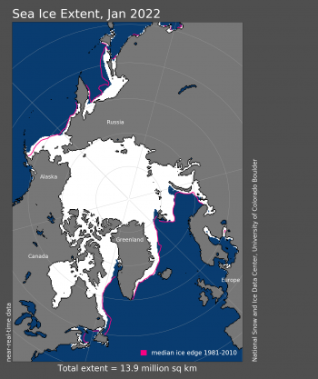
Figure 1a. Arctic sea ice extent for January 2022 was 13.88 million square kilometers (5.36 million square miles). The magenta line shows the 1981 to 2010 average extent for that month. Sea Ice Index data. About the data

Credit: National Snow and Ice Data Center
High-resolution image

Sea ice extent for Arctic January 2022

Figure 1b. The graph above shows Arctic sea ice extent as of February 2, 2022, along with daily ice extent data for four previous years and the record low year. 2021 to 2022 is shown in blue, 2020 to 2021 in green, 2019 to 2020 in orange, 2018 to 2019 in brown, 2017 to 2018 in magenta, and 2012 to 2013 in dashed brown. The 1981 to 2010 median is in dark gray. The gray areas around the median line show the interquartile and interdecile ranges of the data. Sea Ice Index data.

Credit: National Snow and Ice Data Center
High-resolution image

Average Arctic sea ice extent for January 2022 was 13.88 million square kilometers (5.36 million square miles), ranking sixteenth lowest in the satellite record (Figure 1a). The 2022 extent was 540,000 square kilometers (208,000 square miles) below the 1981 to 2010 average. Throughout most of January, extent tracked within the interdecile range of the satellite record, falling below the interdecile range on January 26 (Figure 1b). Regionally, the sea ice extent was above average in the Bering Sea, yet below average in the Sea of Okhotsk and the Barents Sea. Extent also remained lower than average in the Gulf of St. Lawrence. At the end of the month, sea ice extent was above all years since 2009.

Conditions in context

Air temperatures over Arctic Ocean Jan 2022

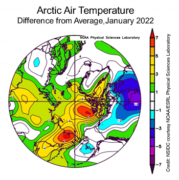
Figure 2a. This plot shows the departure from average air temperature in the Arctic at the 925 hPa level, in degrees Celsius, for January 2022. Yellows and reds indicate higher than average temperatures; blues and purples indicate lower than average temperatures.

Credit: NSIDC courtesy NOAA Earth System Research Laboratory Physical Sciences Laboratory
High-resolution image

Figure 2c. This plot shows the departure from average sea level pressure in the Arctic at the 925 hPa level, in degrees Celsius, for January 2022. Yellows and reds indicate higher than average air pressures; blues and purples indicate lower than average air pressures.||Credit: NSIDC courtesy NOAA Earth System Research Laboratory Physical Sciences Laboratory| High-resolution image

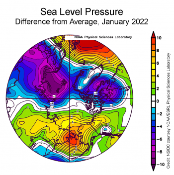
Figure 2b. This plot shows the departure from average sea level pressure in the Arctic in millibars for January 2022. Yellows and reds indicate higher than average air pressures; blues and purples indicate lower than average air pressures.

Credit: NSIDC courtesy NOAA Earth System Research Laboratory Physical Sciences Laboratory
High-resolution image

Air temperatures for January 2022 at the 925 millibar level (about 2,500 feet above the surface) were above average over all of the Arctic Ocean. Temperatures were up to 7 degrees Celsius (13 degrees Fahrenheit) higher than average north of the Canadian Archipelago, with more modest departures in other areas (Figure 2a). The corresponding sea level pressure pattern for January 2022 featured the characteristic Siberian high pressure region that typically forms over eastern Siberia in autumn and winter. However, sea level pressure was up to 8 millibars above average over eastern Siberia, stretching across the Bering Sea and into western Alaska (Figure 2b). This was coupled with below average sea level pressure over Eurasia and Hudson Bay. Generally, when the Siberian High is strong, advection of warm air from eastern Europe leads to mild conditions over the Kara and Laptev Seas. The high over Siberia was also complemented by low pressure south of the Aleutians. This pattern led to winds bringing cold air that enhanced freezing in the Bering Sea and pushed ice southward, leading to the higher extent in the Bering Sea.

January 2022 compared to previous years

Graph of sea ice decline for January since 1979

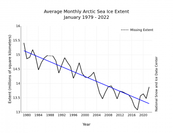
Figure 3. Monthly January ice extent for 1979 to 2022 shows a decline of 3.0 percent per decade.

Credit: National Snow and Ice Data Center
High-resolution image

The downward linear trend in January sea ice extent over the 44-year satellite record is 42,800 square kilometers (16,500 square miles) per year, or 3.0 percent per decade relative to the 1981 to 2010 average. Based on the linear trend, since 1979, January has seen a loss of 1.86 million square kilometers (718,000 square miles). This is equivalent to about four times the area of California.

Role of North Atlantic Heat Transport on Barents Sea ice

Figure x1. Left: simulated mean Arctic Ocean volume transport in Sverdrups (Sv: equal to one million cubic meters per second, or about 260 million gallons per second); right, heat loss in terawatts (TW; equal to one trillion watts) for individual regions. The values shown are average annual values for 1900 to 2000. Credit: Smedsrud et al. 2022

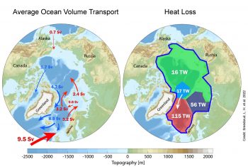
Figure 4a. The left map of the Arctic Ocean shows the simulated average transport of water volume in Sverdrups (Sv: equal to one million cubic meters per second, or about 260 million gallons per second). The right map show the heat loss in terawatts (TW; equal to one trillion watts) for individual regions. The values shown are average annual values for 1900 to 2000.

Credit: Smedsrud et al. 2022
High-resolution image

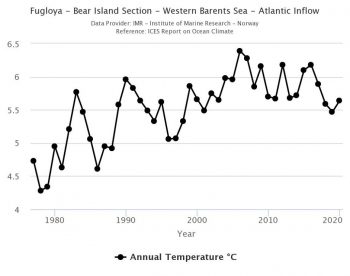
Annual ocean temperatures averaged between 50 and 200m (164 and 656 feet) depth from 1977 through 2020 showing the variation of ocean heat in the western Barents Sea.

Figure 4b. Annual ocean temperatures averaged between 50 and 200 meters (164 and 656 feet) depth from 1977 through 2020 showing the variation of ocean heat in the western Barents Sea.

Credit: Institute of Marine Research, Norway
High-resolution image

The northward flow of warm Atlantic Water along the coast of Norway is a primary oceanic heat source for the Arctic Ocean (Figure 4a). During periods when there is increased transport of Atlantic Water, there is reduced winter sea ice in northern Barents Sea and increased ocean heat loss, leading to denser water. The northward flow of Atlantic water towards the Arctic has been high in recent decades. According to colleagues at the Geophysical Institute in Bergen, Norway, the oceanic heat transport to the Arctic Ocean is 30 percent higher today than it was around 1900.  However, over a shorter time-frame, there is no distinct trend in warm water flow between 1995 and 2020. The total annual transport of ocean heat, a combination of water volume and the temperature of that water, started to decrease after 2015 (Figure 4b). However, while the volume of Atlantic Water through the Barents Sea opening started to drop in 2015, northern Norway experienced several strong storms from the south, that may have broken up the ice cover or kept it from advancing southward. The wind-driven changes in northward movement of Atlantic Water is likely a result of natural climate variability, including both upstream ocean circulation changes and large-scale atmospheric circulation patterns such as the Arctic Oscillation; however, some researchers think that sea ice loss in the Arctic may also be affecting wind patterns.

Antarctic sea ice taking the plunge

Antarctic sea ice extent 2022

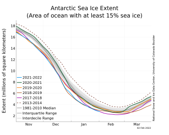
Figure 5a. The graph above shows Antarctic sea ice extent as of February 2, 2022, along with daily ice extent data for five previous years. 2021 to 2022 is shown in blue, 2020 to 2021 in green, 2019 to 2020 in orange, 2018 to 2019 in brown, 2017 to 2018 in magenta, and 2013 to 2014 in dashed brown. The 1981 to 2010 median is in dark gray. The gray areas around the median line show the interquartile and interdecile ranges of the data. Sea Ice Index data.

Credit: National Snow and Ice Data Center
High-resolution image

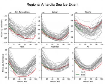
Figure 5. These graphs show Anatarctic sea ice extent in square kilometers in five different regions as well as Antarctica's overall sea ice extent. ||Credit: ?|High-resolution image

Figure 5b. These graphs show Antarctic sea ice extent in square kilometers in five different regions as well as Antarctica’s overall sea ice extent.

Credit: Robbie Mallet, University College London
High-resolution image

During the southern hemisphere spring in 2016, Antarctic sea ice suddenly shrank, leading to a series of months (extending into the 2016 to 2017 austral summer) with the lowest monthly average extents in the satellite data record. This January, Antarctic sea ice was the second lowest ice extent in the 44-year record (Figure 5a). Regionally, ice extent is tracking below levels observed for 2017 in the Indian and Pacific sectors, but above levels for that year in other sectors (Figure 5b). In 2017, only the Ross Sea region had record low extent, so it was the driver of the overall record low hemispheric extent. Similarly, this year none of the individual regions have record low extents, but all are well below average leading to the second lowest Antarctic sea ice in the satellite record, above 2017.

The more moderate extent levels since the record lows in 2016 to 2017 result in a small, not statistically significant (at the 95 percent level) positive trend. Climate models simulating the response to anthropogenic greenhouse gas emissions suggest that Antarctic sea ice should be decreasing. So there is a seeming contradiction between the observations and the models. One possibility is that natural variability is higher than the models indicate and that natural variability may still dominate the Antarctic sea ice trends. A new study led by R. Fogt looked at an ensemble of reconstructions of Antarctic sea ice extent since 1905 using sea level pressure, air temperatures, and indices of climate variability. This study argues that the seasonally observed positive trends since 1979 are unusual over the twentieth century, and that a shift occurred around 1960, before routine satellite observations began. This hints that there is indeed pronounced decadal scale variability in ocean and atmospheric conditions that influence Antarctic sea ice. Whether the low ice conditions of recent years represent a new decadal-scale shift remains to be seen.

References

Årthun, M., T. Eldevik, and L. H. Smedsrud. 2019. The Role of Atlantic Heat Transport in Future Arctic Winter Sea Ice Loss, Journal of Climate32(11), 3327-3341. Retrieved Feb 3, 2022, from https://journals.ametsoc.org/view/journals/clim/32/11/jcli-d-18-0750.1.xml.

Fogt, R.L., A. M. Sleinkofer, M. N. Raphael, et al. 2022. A regime shift in seasonal total Antarctic sea ice extent in the twentieth century. Nature Climate Chang. 12, 54–62. doi:10.1038/s41558-021-01254-9.

Helland-Hansen, B. and F. Nansen. 1909. The Norwegian Sea: Its physical oceanography based upon the Norwegian researches 1900–1904. Det Mallingske bogtrykkeri.

Orvik, K. A. 2022. Long-term moored current and temperature measurements of the Atlantic inflow into the Nordic Seas in the Norwegian Atlantic Current; 1995-2020. Geophysical Research Letters, 49, e2021GL096427. doi:10.1029/2021GL096427

Smedsrud, L. H., M. Muilwijk, A. Brakstad, E. Madonna, S. K. Lauvset, C. Spensberger, C., et al. 2022. Nordic Seas heat loss, Atlantic inflow, and Arctic sea ice cover over the last century. Reviews of Geophysics, 60, e2020RG000725. doi:10.1029/2020RG000725.

Erratum

On February 9, 2022, a user informed the ASINA team of an error in the text, which stated, “January 2022 finished as the sixteenth lowest extent in the satellite record above all years since 2009, with the exception of 2013 and 2014.” The correct text should state that “January 2022 finished as the sixteenth lowest extent in the satellite record above all years since 2009.” The correction has been made.

A mixed-bag of Arctic sea ice

Sea ice extent increased at a faster than average pace through November and by the end of the month, extent was just within the interdecile range. Extent was above average in the Bering Sea, but Hudson Bay remained unusually ice free through the month.

Overview of conditions

Figure 1. Arctic sea ice extent for XXXX 20XX was X.XX million square kilometers (X.XX million square miles). The magenta line shows the 1981 to 2010 average extent for that month. Sea Ice Index data. About the data||Credit: National Snow and Ice Data Center|High-resolution image

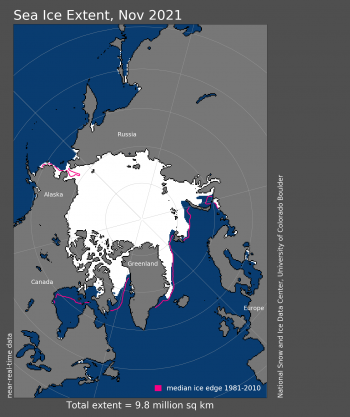
Figure 1. Arctic sea ice extent for November 2021 was 9.77 million square kilometers (3.77 million square miles). The magenta line shows the 1981 to 2010 average extent for that month. Sea Ice Index data. About the data

Credit: National Snow and Ice Data Center
High-resolution image

The November 2021 monthly average extent was 9.77 million square kilometers (3.77 million square miles), which ranked tenth lowest in the satellite record. The 2021 extent was 930,000 square kilometers (359,000 square miles) below the 1981 to 2010 long-term average. Extent was higher than average in the Bering Sea, but is extremely low in Hudson Bay.

Conditions in context

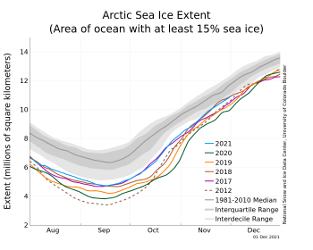
Figure 2a. The graph above shows Arctic sea ice extent as of XXXXX XX, 20XX, along with daily ice extent data for four previous years and the record low year. 2021 is shown in blue, 2020 in green, 2019 in orange, 2018 in brown, 2017 in magenta, and 2012 in dashed brown. The 1981 to 2010 median is in dark gray. The gray areas around the median line show the interquartile and interdecile ranges of the data. Sea Ice Index data.||Credit: National Snow and Ice Data Center|High-resolution image

Figure 2a. The graph above shows Arctic sea ice extent as of December 1 2021, along with daily ice extent data for four previous years and the record low year. 2021 is shown in blue, 2020 in green, 2019 in orange, 2018 in brown, 2017 in magenta, and 2012 in dashed brown. The 1981 to 2010 median is in dark gray. The gray areas around the median line show the interquartile and interdecile ranges of the data. Sea Ice Index data.

Credit: National Snow and Ice Data Center
High-resolution image

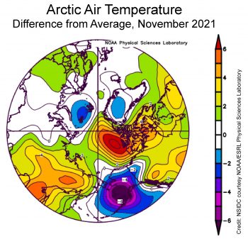
Figure 2X. This plot shows the departure from average air temperature in the Arctic at the 925 hPa level, in degrees Celsius, for XXXmonthXX 20XX. Yellows and reds indicate higher than average temperatures; blues and purples indicate lower than average temperatures.||Credit: NSIDC courtesy NOAA Earth System Research Laboratory Physical Sciences Laboratory| High-resolution image

Figure 2b. This plot shows the departure from average air temperature in the Arctic at the 925 hPa level, in degrees Celsius, for November 2021. Yellows and reds indicate higher than average temperatures; blues and purples indicate lower than average temperatures.

Credit: NSIDC courtesy NOAA Earth System Research Laboratory Physical Sciences Laboratory
High-resolution image

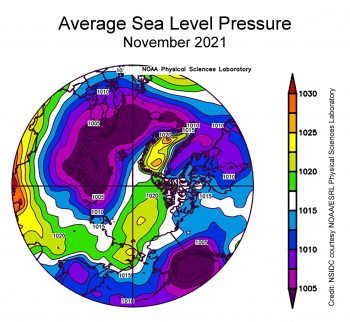
Figure 2X. This plot shows average sea level pressure in the Arctic in millibars for XXXmonthXX 20XX. Yellows and reds indicate high air pressure; blues and purples indicate low pressure.||Credit: NSIDC courtesy NOAA Earth System Research Laboratory Physical Sciences Laboratory| High-resolution image

Figure 2c. This plot shows average sea level pressure in the Arctic in millibars for November 2021. Yellows and reds indicate high air pressure; blues and purples indicate low pressure.

Credit: NSIDC courtesy NOAA Earth System Research Laboratory Physical Sciences Laboratory
High-resolution image

Air temperatures at the 925 millibar level (about 2,500 feet above the surface) were well above average north of the Canadian Archipelago, by as much as 6 degrees Celsius (11 degrees Fahrenheit). Conversely, temperatures over southwest Alaska and the eastern sector of the Bering Sea were as much as 6 degrees Celsius (11 degrees Fahrenheit) below average (Figure 2b).

The sea level pressure pattern for November featured widespread low pressure over the Atlantic side of the Arctic and extending into the Barents and Kara Seas, paired with a moderately strong Beaufort Sea High (Figure 2c). Strong low pressure over the Gulf of Alaska resulted in a circulation pattern in the eastern Bering Sea that brought cold air from the north. This pattern was favorable for sea ice growth, and can explain the above average ice extent in the region.

November 2021 compared to previous years

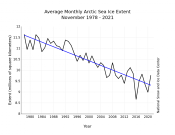
Figure 3. Monthly XXXXX ice extent for 1979 to 20XX shows a decline of X.X percent per decade.||Credit: National Snow and Ice Data Center| High-resolution image

Figure 3. Monthly November ice extent for 1979 to 2021 shows a decline of 5.0 percent per decade.

Credit: National Snow and Ice Data Center
High-resolution image

The downward linear trend in November sea ice extent over the 43-year satellite record is 53,300 square kilometers (20,600 square miles) per year, or 5 percent per decade relative to the 1981 to 2010 average. Also based on the linear trend, since 1979, November has lost 2.2 million square kilometers (849,000 square miles). This is equivalent to about three times the size of Texas.

No freeze in Hudson Bay

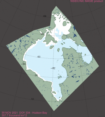
Figure 4. This map of Hudson Bay shows sea ice extent as of November 30, 2021. Data are from the NSIDC Multisensor Analyzed Sea Ice Extent (MASIE) product. ||Credit: National Snow and Ice Data Center|High-resolution image

Figure 4. This map of Hudson Bay shows sea ice extent as of November 30, 2021. The US National Ice Center/NSIDC Multisensor Analyzed Sea Ice Extent (MASIE) product provides the data for this map.

Credit: US National Ice Center and National Snow and Ice Data Center
High-resolution image

Typically, Hudson Bay begins freezing up by the beginning of November. By the end of the month, the northern half of the bay is usually completely iced over. However, as of the end of November 2021, only the far north has frozen over; the rest of the bay is ice free except for a narrow band of ice along the western coastline. According to the NSIDC Sea Ice Index, this is the second lowest extent in Hudson Bay at this time, above only 2010.

The USNIC/NSIDC Multisensor Analyzed Sea Ice Extent (MASIE) product provides a more detailed view (Figure 4). It also shows ice only in the far north of the region and along the western coast. The lack of ice has potential ramifications for polar bears in the region that must wait for the bay to freeze over to hunt. While the lack of ice in Hudson Bay at this time of year is extreme, the bay will eventually freeze over through the coming winter.

Frozen in the Northern Sea Route

An early freeze of sea-ice has lead to logistical chaos on the Northern Sea Route. ||Credit: Rosatomflot via The Independent Barents Observer)

An early freeze of sea-ice has led to logistical chaos on the Northern Sea Route.

Credit: Rosatomflot via The Independent Barents Observer
High-resolution image

The story on the opposite side of the Arctic stands in sharp contrast to Hudson Bay. Ice formed along the eastern part of the Siberian coast relatively early, at least compared to recent years. This caught ships transiting through the Northern Sea Route by surprise. Several have become frozen in and are awaiting icebreakers to free them. In addition to the surprisingly early freeze up, winds also pushed ice together into ridges (piled up ice) that are much more difficult to navigate through. Supplies to northern Siberian cities have been delayed.

Springtime in the South

Figure 5. Figure 5. This maps shows Antarctic sea ice concentration on November 30, 2021. The yellow area shows missing data. The orange line shows the 1981 to 2010 average extent for that day. Sea Ice Index data. About the data||Credit: National Snow and Ice Data Center|High-resolution image

Figure 5. This maps shows Antarctic sea ice concentration on December 1, 2021. The yellow area shows missing data. The orange line shows the 1981 to 2010 average extent for that day. Sea Ice Index data. About the data

Credit: National Snow and Ice Data Center
High-resolution image

In the Antarctic, ice extent declined relatively rapidly during the austral spring. By the end of November, extent was the second lowest in the satellite record, bested only by the extreme low recorded in 2016. Extent was particularly low in the Bellingshausen and Weddell Seas as well as in the Indian Ocean sector, north of Enderby Land. The Maud Rise polynya has once again formed. This feature was not seen for many years after the 1970s, but has started to form in recent years.

ASINA team member Ted Scambos is currently on his way to Antarctica for field work.

Reference

US National Ice Center and National Snow and Ice Data Center. Compiled by F. Fetterer, M. Savoie, S. Helfrich, and P. Clemente-Colón. 2010, updated daily. Multisensor Analyzed Sea Ice Extent – Northern Hemisphere (MASIE-NH), Version 1. Boulder, Colorado USA. NSIDC: National Snow and Ice Data Center. doi:10.7265/N5GT5K3K.

September turning

The summer melt season has come to a modest end. The summer of 2021 was relatively cool compared to the most recent years and September extent was the highest since 2014. It was nevertheless an eventful summer, with many twists and turns.

Overview of conditions
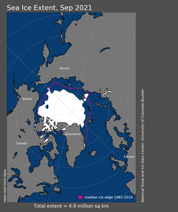
Figure 1. Arctic sea ice extent for September 2021

Figure 1a. Arctic sea ice extent for September 2021 was 4.92 million square kilometers (1.90 million square miles). The magenta line shows the 1981 to 2010 average extent for that month. Sea Ice Index data. About the data

Credit: National Snow and Ice Data Center
High-resolution image
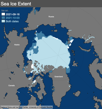
The map above compares the 2012 Arctic sea ice minimum, reached on September 17, with the 2020 Arctic sea ice minimum, reached on September 15. Light blue shading indicates the region where ice occurred in both 2012 and 2020, while white and medium blue areas show ice cover unique to 2012 and to 2020, respectively. Sea Ice Index data. About the data Credit: National Snow and Ice Data Center High-resolution image

Figure 1b. The map above compares the annual minimum set on September 16, 2021, with October 3, 2021. Light blue shading indicates the region where ice occurred on both dates, while white and medium blue areas show ice cover unique to September 16, 2021 and October 3, 2021, respectively. Sea Ice Index data. About the data

Credit: National Snow and Ice Data Center
High-resolution image

Arctic sea ice extent for September averaged 4.92 million square kilometers (1.90 million square miles), the twelfth lowest in the 43-year satellite record. This is 1.35 million square kilometers (521,000 square miles) above the record low set in September 2012, and 1.49 million square kilometers (575,000 square miles) below the 1981 to 2010 average. The last 15 years (2007 to 2021) have had the 15 lowest September extents in the record.

The annual minimum extent occurred on September 16 and was the twelfth lowest minimum in the satellite record. Afterwards, ice extent increased primarily in the Beaufort Sea region, with the large irregular open water region that existed in mid-September filling in with ice (Figure 1b). The ice edge also expanded in the East Siberian Sea. The East Greenland Sea has been largely ice free for much of the summer, but sea ice is now expanding southward.

Conditions in context
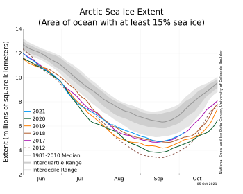
baah

Figure 2a. The graph above shows Arctic sea ice extent as of October 5, 2021, along with daily ice extent data for four previous years and the record low year. 2021 is shown in blue, 2020 in green, 2019 in orange, 2018 in brown, 2017 in magenta, and 2012 in dashed red. The 1981 to 2010 median is in dark gray. The gray areas around the median line show the interquartile and interdecile ranges of the data. Sea Ice Index data.

Credit: National Snow and Ice Data Center
High-resolution image
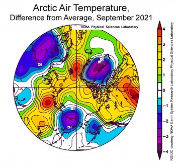
temperature anomaly for September 2021

Figure 2b. This plot shows the departure from average air temperature in the Arctic at the 925 hPa level, in degrees Celsius, for September 2021. Yellows and reds indicate higher than average temperatures; blues and purples indicate lower than average temperatures.

Credit: NSIDC courtesy NOAA Earth System Research Laboratory Physical Sciences Laboratory
High-resolution image

After the minimum set on September 16, extent began rising fairly rapidly as the scattered open water areas in the Beaufort and Chukchi Seas began to fill in (Figure 2a). Ocean temperatures remained low in this region because of the late ice retreat that limited the amount of solar insolation absorbed by the ocean. The cooler ocean allowed a quick freeze up as air temperatures dropped below freezing. Overall, extent increased 430,000 square kilometers (166,000 square miles) between the 16 and the end of the month, about the same as the increase for the 1981 to 2010 average.

During September, air temperatures at the 925 mb (about 2,500 feet above the surface) were higher than average over most of the Arctic Ocean (Figure 2b). Temperatures were up to 4 degrees Celsius (7 degrees Fahrenheit) above average in the East Greenland Sea, likely reflecting the unusual lack of ice in the region, allowing ocean heat to warm the lower atmosphere. The one notable cold region was in the East Siberian Sea; temperatures in the last two weeks of September were 3 to 4 degrees Celsius (5 to 7 degrees Fahrenheit) below average.

September 2021 compared to previous years
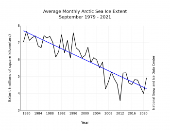
Figure 3. Monthly XXXXX ice extent for 1979 to 20XX shows a decline of X.X percent per decade.||Credit: National Snow and Ice Data Center| High-resolution image

Figure 3. Monthly September ice extent for 1979 to 2021 shows a decline of 12.7 percent per decade.

Credit: National Snow and Ice Data Center
High-resolution image

The downward linear trend in September sea ice extent over the satellite records is 81,200 square kilometers (31,400 square miles) per year, or 12.7 percent per decade relative to the 1981 to 2010 average (Figure 3). September marks the month of the largest linear trend in ice extent, both in absolute terms and percentage loss. Overall, since 1979, September has lost 3.49 million square kilometers (1.35 million square miles) of ice, based on the linear trend values. This is equivalent to about twice the size of Alaska.

There was little net change in extent over the month of September—extent declined during the first half of the month and then increased in the second half. This year, extent was 5.17 million square kilometers (2.00 million square miles) on September 1 and 5.15 million square kilometers (1.99 million square miles) on September 30.

Antarctica’s unusual sea ice maximum
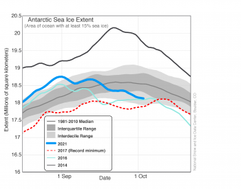
Figure 2. The graph above shows Antarctic sea ice extent

Figure 4a. The graph above shows Antarctic sea ice extent as of October 3, 2021, along with daily ice extent data for three previous years including the record low year. 2021 is shown in blue, 2016 in green, 2014 in black, and 2017 in dashed red. The 1981 to 2010 median is in dark gray. The gray areas around the median line show the interquartile and interdecile ranges of the data. Sea Ice Index data.

Credit: National Snow and Ice Data Center
High-resolution image
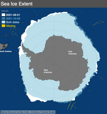
Figure 4b. This map compares Antarctic sea ice extent for September 1, 2021, with October 3, 2021. Light blue

Figure 4b. This map compares Antarctic sea ice extent for September 1, 2021, with October 3, 2021. Light blue shading indicates the region where ice occurred on both dates, while white and medium blue areas show ice cover unique to September 1, 2021 and October 3, 2021, respectively. Sea Ice Index data. About the data

Credit: National Snow and Ice Data Center
High-resolution image

As noted in our earlier posts, Antarctic sea ice extent has been above average for the past several months, culminating in late August when extent was the fifth highest in the satellite record (Figure 4a). However, since peaking on September 1, sea ice extent has declined steeply. At the beginning of October, Antarctic sea ice extent was nearly 600,000 square kilometers (232,000 square miles) lower than the beginning of the month (Figure 4a). The maximum observed on September 1 was 18.75 million square kilometers (7.24 million square miles) is very likely to be the annual maximum for the year, marking the second-earliest seasonal maximum in the 43-year satellite record. Sea ice loss since September 1 has been greatest in the Ross Sea, Bellingshausen Sea, and Weddell Sea sectors (Figure 4b).

For the interior of the Antarctic continent, specifically the region near the South Pole, the winter of 2021 was among the coldest on record. At the National Science Foundation’s Amundsen-Scott South Pole Station, temperatures for June, July, and August were 3.4 degrees Celsius (6.1 degrees Fahrenheit) lower than the 1981-to-2010 average at -62.9 degrees Celsius (-81.2 degrees Fahrenheit). This is the second coldest winter (June-July-August months) on record, behind only 2004 in the 60-year weather record at the South Pole Station. For the polar darkness period, from April through September, the average temperature was -60.9 degrees Celsius (-77.6 degrees Fahrenheit), a record for those months. The unusual cold was attributed to two extended periods of stronger-than-average encircling winds around the continent, which tend to isolate the ice sheet from warmer conditions. A strong upper-atmosphere polar vortex was observed as well, leading to a significant ozone hole. The ozone hole appears to have peaked as of this post, with initial measurements reporting that it is in the upper quartile (top 25 percent) of ozone reduction events since 1979.

2021 Arctic summer in review
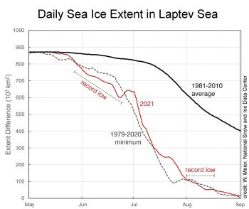
Laptev Sea daily ice extent

Figure 5a. This graph shows daily sea ice extent in the Laptev Sea for May through September for 2021 (red) and the 1979 to 2020 minimum (dashed gray) as compared to the 1981 to 2010 average. At two periods in time the Laptev sea ice extent in 2021 fell to the lowest extent in the satellite record, as marked in red “record low.”

Credit: W. Meier, National Snow and Ice Data Center
High-resolution image
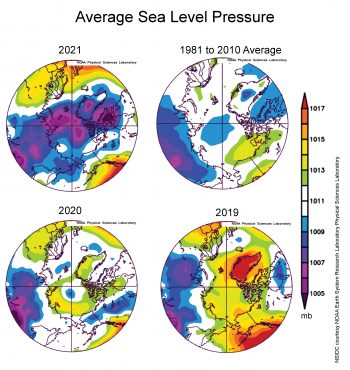
Figure 4b. This plot shows average sea level pressure in the Arctic in millibars for 2019, 2020, 2021, and the 1981 to 2010 average. Yellows and reds indicate high air pressure; blues and purples indicate low pressure.||Credit: NSIDC courtesy NOAA Earth System Research Laboratory Physical Sciences Laboratory| High-resolution image

Figure 5b. This plot shows average sea level pressure in the Arctic in millibars for 2019, 2020, 2021, and the 1981 to 2010 average. Yellows and reds indicate high air pressure; blues and purples indicate low pressure.

Credit: NSIDC courtesy NOAA Earth System Research Laboratory Physical Sciences Laboratory
High-resolution image
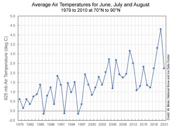
June July August air temperatures from 1979 to 2021

Figure 5c. This graph shows the months of June, July, and August (JJA) at 925 mb air temperature averaged over 70 to 90 degrees N latitude for 1979 to 2021.

Credit: National Centers for Environmental Prediction/National Center for Atmospheric Research (NCEP/NCAR) Reanalysis
High-resolution image
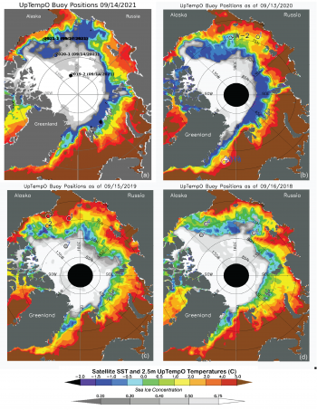
Figure 7. Sea surface temperatures in mid-September for (a) 2021, (b) 2020, (c) 2019, (d) 2018. SST data from NOAA. Circles indicate buoy data points with SST or sea ice concentration. From UpTempO.

Figure 5d. These maps show sea surface temperatures (SST) in mid-September for (a) 2021, (b) 2020, (c) 2019, and (d) 2018. SST data from are from the National Ocean and Atmospheric Administration (NOAA). Circles indicate buoy data points with SST or sea ice concentration.

Credit: Upper layer Temperature of the Polar Oceans (UpTempO), University of Washington
High-resolution image
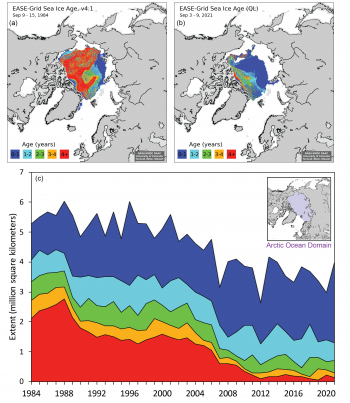
Figure 4e. Sea ice age at the week of the minimum for (a) 1984, (b) 2021, and (c) timeseries of total extent of age categories for 1984 to 2021, within the Arctic Ocean Domain (inset). From Tschudi et al., 2019a and Tschudi et al., 2019b.

Figure 5e. The top maps show sea ice age at the week of the minimum for 1984, on the left, and 2021, on the right. The bottom time series graph shows the total extent of age categories for 1984 to 2021, within the Arctic Ocean Domain (inset).

Credit: Tschudi et al., 2019a and Tschudi et al., 2019b
High-resolution image

The spring and summer of 2021 were notable for the extremely early melt and retreat of ice in the Laptev Sea, resulting in record low June sea ice extent in that region and much lower extent compared to average throughout the summer (Figure 5a). By contrast, sea ice retreat within the Beaufort and Chukchi Seas was slow and the ice edge remained near its long-term average position throughout summer. At least in part, this reflects the unusually strong transport of thick, old ice into the region during winter; thicker ice is more resistant to melting out in summer. Another interesting feature was the lack of summer ice in the East Greenland Sea. Transport of ice through Fram Strait southward generally feeds a tongue of ice along the eastern coast of Greenland through summer. The lack of summer ice this year can be tied to wind patterns inhibiting this southward flow of ice. Thinner ice encountering warm Atlantic waters may have also played a role.

The summer of 2021 was dominated by low sea level pressure over the Arctic Ocean and a lack of a strong Beaufort Gyre circulation (Figure 5b). Cyclone activity over the central Arctic Ocean tends to peak in summer, with cyclones forming over the Eurasian continent migrating into the region and cyclogenesis (cyclone formation) over the Arctic Ocean itself. However, the pattern is quite variable. While the summer of 2021 was characterized by frequent cyclone activity, other summers, like 2019 and 2020, had few cyclones in that region where high pressure prevailed (Figure 5b). Cyclones found over the central Arctic Ocean are of a type known as “cold cored,” which helps to account for the summer of 2021 being fairly cool (Figure 5c).

The ocean surface also remained relatively cool during summer 2021. Sea surface temperatures (SSTs) at summer’s end were lower than the three previous years, based on buoys and the National Oceanic and Atmospheric Administration satellite data (Figure 5d). The summer of 2021 had widespread areas of near-freezing SSTs near the ice edge; this is indicative of late season ice melt cooling the surface and little incoming solar radiation. Low SSTs enable rapid freeze up, as is occurring in those regions. Also, the area with SSTs greater than 5 degrees Celsius (9 degrees Fahrenheit), is much smaller and widespread than in recent years.

Despite September total ice extent being high compared to recent years, the amount of multiyear ice as assessed from ice age (Figure 5e) reached a near-record low, with an extent of only 1.29 million square kilometers (498,000 square miles), just slightly above the value of 1.27 million square kilometers (490,000 square miles) at the end of the 2012 melt season.

IceBird: Summer sea ice thickness north of Greenland and Fram Strait
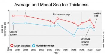
sea ice thickness using two methods

Figure 6. This graph shows average, in red, and modal, in blue, sea ice thickness from the IceBird campaigns between 2001 and 2021. The average thickness is the average of all estimates; the modal thickness is the most frequently observed thickness estimate.

Credit: Belter et al. 2021
High-resolution image

In August 2021, the IceBird Summer campaign continued its observations of sea ice thickness north of Greenland and within northern Fram Strait by means of airborne electromagnetic sounding. Our colleagues J. Belter, T. Krumpen, S. Hendricks, and C. Haas at the Alfred Wegener Institute provided a summary of the campaign. The observed average sea ice thickness of 1.7 meters (5.6 feet) was among the lowest observed since 2001 (Figure 6). Ice motion tracking reveals that the sea ice in this area was originally first-year ice that formed in the shallow shelf in the central Laptev Sea. It was then transported across the Arctic Ocean via the Transpolar Drift Stream. Near the campaign’s base at Station Nord, the reoccurrence of the Wandel Sea polynya led to enhanced melting once the winds had dispersed the ice north.

Nansen Legacy: The northern Barents Sea before and during the 2021 melt season
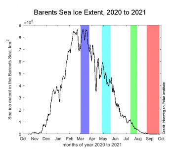
Figure 6b. This graph shows sea ice extent in the Barents Sea from the Multisensor Analyzed Sea Ice Extent - Northern Hemisphere (MASIE-NH) MASIE product, with the periods of the four cruises highlighted in color.

Figure 7a. This graph shows sea ice extent in the Barents Sea from the Multisensor Analyzed Sea Ice Extent – Northern Hemisphere (MASIE-NH) product, with the periods of the four cruises highlighted in color.

Credit: Norwegian Polar Institute
High-resolution image
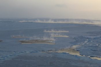
Photograph of sea ice north of Svalbard

Figure 7b. Sea smoke in leads in between sea ice northeast of Svalbard in March 2021, during a Nansen Legacy research expedition with RV Kronprins Haakon, illustrating the heat exchange between the cold atmosphere and relatively warmer ocean. 

Credit: Sebastian Gerland, Norwegian Polar Institute
High-resolution image

During March to September 2021 a series of interdisciplinary research expeditions to the northern Barents Sea were conducted as part of the Norwegian “Nansen Legacy” project. A dedicated sea ice research team worked alongside researchers focused on ocean and ecosystem dynamics, with the aim of understanding the northern Barents Sea ocean, ice, and ecosystem interactions over the period from the regional sea ice maximum to seasonally ice-free conditions (Figure 7a). Our colleagues D. Divine, S. Gerland, A. Steer, and S. Lind at the Norwegian Polar Institute in Tromsø, Norway, provided a summary of the expeditions.

Observations during the voyages revealed a highly dynamic sea ice cover in the area. In March, the northern Barents Sea was covered with mainly level 0.4-to-0.6-meters (1.3-to-2.0-feet) thick sea ice, locally formed sea ice with a tendency towards a greater fraction of ridged ice north of Svalbard. This type of ice persisted in the central Barents Sea through April and May. Long-lasting, stable cold conditions in February to mid-March promoted the formation of large ice floes—often more than 1 square kilometer (0.39 square miles). This relatively thin ice cover experienced a rapid transformation during a single storm event from March 22 to 24, 2021, breaking into floes ranging from 20 to 100 meters (66 to 328 feet) length. At the shelf-break north of the Barents Sea in March 2021, the team observed strong heat losses from the ocean surface, seen as sea smoke (Figure 7b). Measurements also revealed upward oceanic heat fluxes from the deeper Atlantic layer, situated below about 100 meters (328 feet) depth. This likely limited local sea ice production in this region. The relatively warm water in the upper 100 meter (328 feet) likely prevented the ice from further thickening in this region, despite continuous cold atmospheric conditions in the area with air temperatures below -20 degrees Celsius (-4 degrees Fahrenheit), favorable for ice growth.

From May through July, the area northeast of Svalbard was dominated by 1.0 to 1.5 meters (3.3 to 4.9 feet) thick first-year ice that originated in the central Arctic Ocean. In July, sea ice was present only in the very north end of the research area, near the boundary with the Nansen Basin. By August and September, this part of the Barents Sea was ice free.

Acknowledgements

Thanks to Matthew Lazzara of the Antarctic Meteorological Research and Data Center at the University of Wisconsin-Madison, and to Kyle Clem of Victoria University in Wellington, New Zealand.

Further reading

Belter, H. J., T. Krumpen, L. V. Albedyll, T. A. Alekseeva, G. Birnbaum, S. V. Frolov, S. Hendricks, A. Herber, I. Polyakov, I. Raphael, R. Ricker, S. S. Serovetnikov, M. Webster, and C. Haas. 2021. Interannual variability in Transpolar Drift summer sea ice thickness and potential impact of Atlantification. The Cryosphere, 15, 6, 2575-2591, doi:10.5194/tc-15-2575-2021.

Krumpen, T., H. J. Belter, A. Boetius, et al. 2019. Arctic warming interrupts the Transpolar Drift and affects long-range transport of sea ice and ice-rafted matter. Scientific Reports 9, 5459, doi:10.1038/s41598-019-41456-y.

Mallett, R. D. C., J. C. Stroeve, S. B. Cornish, et al. 2021. Record winter winds in 2020/21 drove exceptional Arctic sea ice transport. Communications Earth & Environment 2, 149, doi:10.1038/s43247-021-00221-8

Erratum

On October 13, NSIDC scientists clarified the wording regarding the coldest winter on record for Antarctica: For the interior of the Antarctic continent, specifically the region near the South Pole, the winter of 2021 was among the coldest on record.
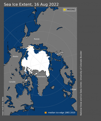
Arctic sea ice at highest minimum since 2014

On September 16, Arctic sea ice likely reached its annual minimum extent of 4.72 million square kilometers (1.82 million square miles). The 2021 minimum is the twelfth lowest in the nearly 43-year satellite record. The last 15 years are the lowest 15 sea ice extents in the satellite record. The amount of multi-year ice (ice that has survived at least one summer melt season), is one of the lowest levels in the ice age record, which began in 1984.

In the Antarctic, sea ice extent is now falling rapidly, but it is still too early to assume that the maximum has been reached. The maximum for Antarctic sea ice typically occurs in late September or early October. However, Antarctic sea ice extent is highly variable near the maximum because of storms acting to expand or compact the extended ice edge.

Please note that this is a preliminary announcement. Changing winds or late-season melt could still reduce the Arctic ice extent, as happened in 2005 and 2010. NSIDC scientists will release a full analysis of the Arctic melt season, and discuss the Antarctic winter sea ice growth, in early October.

Overview of conditions

Figure 1. Arctic sea ice extent for September 15, 2020 was 3.74 million square kilometers (1.44 million square miles). The orange line shows the 1981 to 2010 average extent for that day. Sea Ice Index data. About the data||Credit: National Snow and Ice Data Center|High-resolution image

Figure 1. Arctic sea ice extent for September 16, 2021, was 4.72 million square kilometers (1.82 million square miles). The orange line shows the 1981 to 2010 average extent for that day. Sea Ice Index data. About the data

Credit: National Snow and Ice Data Center
High-resolution image

On September 16, sea ice reached its annual minimum extent of 4.72 million square kilometers (1.82 million square miles) (Figure 1). In response to the setting sun and falling temperatures, ice extent has begun rising and will continue to rise through autumn and winter. However, a shift in wind patterns or a period of late season melt could still push the ice extent lower.

The minimum extent was reached two days later than the 1981 to 2010 median minimum date of September 14. The interquartile range of minimum dates is September 11 to September 19.

Conditions in context

Figure 2a. The graph above shows Arctic sea ice extent on September 15, 2020, along with several other recent years and the record minimum set in 2012. 2019 is shown in green, 2018 in orange, 2017 in brown, 2016 in magenta, and 2012 in dashed brown. The 1981 to 2010 median is in dark gray. The gray areas around the median line show the interquartile and interdecile ranges of the data. Sea Ice Index data. Credit: National Snow and Ice Data Center High-resolution image

Figure 2. The graph above shows Arctic sea ice extent on September 16, 2021, along with several other recent years and the record minimum set in 2012. 2021 is shown in blue, 2020 in green, 2019 in orange, 2018 in brown, 2017 in magenta, and 2012 in dashed brown. The 1981 to 2010 median is in dark gray. The gray areas around the median line show the interquartile and interdecile ranges of the data. Sea Ice Index data.

Credit: National Snow and Ice Data Center
High-resolution image

This year’s minimum set on September 16 was 1.33 million square kilometers (514,000 square miles) above the record minimum extent in the satellite era, which occurred on September 17, 2012 (Figure 2). It is also 1.50 million square kilometers (579,000 square miles) below the 1981 to 2010 average minimum extent, which is equivalent to twice the size of Texas.

In the 43-year-satellite record, 15 of the lowest minimums have all occurred in the last 15 years.

Multiyear ice extent is one of the lowest on record. First-year-ice coverage increased dramatically since last year, jumping from 1.58 million square kilometers (610,000 square miles) to 2.71 million square kilometers (1.05 million square miles). The increase in total extent from last year’s minimum to this year’s is hence comprised of first-year ice.
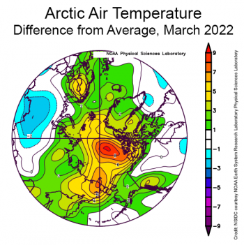
The overall, downward trend in the minimum extent from 1979 to 2021 is 13.0 percent per decade relative to the 1981 to 2010 average. The loss of sea ice is about 80,600 square kilometers (31,100 square miles) per year, equivalent to losing the size of the state of South Carolina or the country of Austria annually.

Fifteen lowest minimum Arctic sea ice extents (satellite record, 1979 to present)

Table 1. Fifteen lowest minimum Arctic sea ice extents (satellite record, 1979 to present)
RANK YEAR MINIMUM ICE EXTENT DATE
IN MILLIONS OF SQUARE KILOMETERS IN MILLIONS OF SQUARE MILES
1 2012 3.39 1.31 Sept. 17
2 2020 3.82 1.47 Sept. 16
3 2007
2016
2019
4.16
4.17
4.19
1.61
1.61
1.62
Sept. 18
Sept. 10
Sept. 18
6 2011 4.34 1.68 Sept. 11
7 2015 4.43 1.71 Sept. 9
8 2008
2010
4.59
4.62
1.77
1.78
Sept. 19
Sept. 21
10 2018
2017
4.66
4.67
1.80
1.80
Sept. 23
Sept. 13
12 2021 4.72 1.82 Sept. 16
13 2014
2013
5.03
5.05
1.94
1.95
Sept. 17
Sept. 15
15 2009 5.12 1.98 Sept. 13

Values within 40,000 square kilometers (15,000 square miles) are considered tied. The 2020 value has changed from 3.74 to 3.82 million square kilometers (1.47 million square miles) when final analysis data updated near-real-time data. The 2020 date of minimum also changed from September 15 to September 16. 

On the home stretch

Sea ice loss during the first half of August stalled, though ice in the Beaufort Sea is finally starting to weaken. The Northern Sea Route appears closed off in 2021, despite being open each summer since 2008.

Overview of conditions

Figure 1. Arctic sea ice extent for XXXX XX, 20XX was X.XX million square kilometers (X.XX million square miles). The orange line shows the 1981 to 2010 average extent for that day. Sea Ice Index data. About the data||Credit: National Snow and Ice Data Center|High-resolution image

Figure 1a. Arctic sea ice extent for August 17, 2021 was 5.77 million square kilometers (2.23 million square miles). The orange line shows the 1981 to 2010 average extent for that day. Sea Ice Index data. About the data

Credit: National Snow and Ice Data Center
High-resolution image

Figure 1b. This satellite image of the Arctic Ocean on August 8, 2021, shows sea ice break up in the Northern Chukchi and Beaufort Seas. The magenta outline depicts smoke from Siberian fires moving over Arctic sea ice. The Moderate Resolution Imaging Spectroradiometer (MODIS) on board NASA's Terra and Aqua satellites took this image. ||Credit: National Snow and Ice Data Center/NASA Worldview|High-image resolution

Figure 1b. This satellite image of the Arctic Ocean on August 8, 2021, shows sea ice break up in the Northern Chukchi and Beaufort Seas. The magenta outline depicts smoke from Siberian fires moving over Arctic sea ice. The Moderate Resolution Imaging Spectroradiometer (MODIS) on board NASA’s Terra and Aqua satellites took this image.

Credit: National Snow and Ice Data Center/NASA Worldview
High-image resolution

As of August 17, sea ice extent stood at 5.77 million square kilometers (2.23 million square miles), tracking above the last six years, as well as 2011, 2012, and 2007 (Figure 1a). Sea ice loss stalled between August 8 and 11 before picking up the pace again. While overall decline in total ice extent has slowed, the ice cover is becoming more diffuse within the northern Chukchi Sea and the western Beaufort Sea. Further reductions are likely in that region (Figure 1b). Ice motion during the first week of August pushed sea ice in the Beaufort Sea southwards, and ice within the Chukchi Sea moved towards the East Siberian Sea. While sea ice in the western Arctic has been more extensive than in recent summers, the Laptev Sea has lost more sea ice thus far than at any other time in the satellite record. However, ice remains south of Severnaya Zemlya in the Kara Sea, blocking the Northern Sea Route. Further south in the East Greenland Sea, there is only 119,000 square kilometers (45,900 square miles) of sea ice, the second least amount of ice for this time of year following 2002.
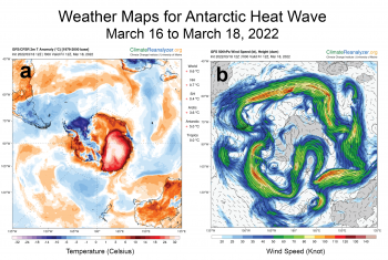
Conditions in context

Figure 1. Arctic sea ice extent for XXXX XX, 20XX was X.XX million square kilometers (X.XX million square miles). The orange line shows the 1981 to 2010 average extent for that day. Sea Ice Index data. About the data||Credit: National Snow and Ice Data Center|High-resolution image

Figure 2a. Arctic sea ice extent for August 17, 2021 was 5.77 million square kilometers (2.23 million square miles). The orange line shows the 1981 to 2010 average extent for that day. Sea Ice Index data. About the data

Credit: National Snow and Ice Data Center
High-resolution image

Figure 2X. This plot shows the departure from average sea level pressure in the Arctic at the 925 hPa level, in degrees Celsius, for XXXmonthXX 20XX. Yellows and reds indicate higher than average air pressures; blues and purples indicate lower than average air pressures.||Credit: NSIDC courtesy NOAA Earth System Research Laboratory Physical Sciences Laboratory| High-resolution image

Figure 2b. This plot shows the departure from average air temperature in the Arctic at the 925 hPa level, in degrees Celsius, between August 1 to 15, 2021. Yellows and reds indicate higher than average temperatures; blues and purples indicate lower than average temperatures.

Credit: NSIDC courtesy NOAA Earth System Research Laboratory Physical Sciences Laboratory
High-resolution image

An unusually strong high-pressure system dominated over Siberia during the first half of August, extending towards the pole. This high pressure was coupled by low pressure over the Greenland Ice Sheet, promoting strong southwards ice motion from the center of the Arctic Ocean towards the North American and Siberian coastlines. Overall, air temperatures at the 925 millibar level (about 2,500 feet above the surface) were about 2 to 5 degrees Celsius (4 to 9 degrees Fahrenheit) above average over most of the Arctic Ocean, with air temperatures up to 7 degrees Celsius (13 degrees Fahrenheit) above average in the Kara Sea near Severnaya Zemlya (Figure 2b). However, while temperatures have mostly been higher than average, this is the time of the year when air temperatures start to drop as the sun dips lower on the horizon. Surface melting ends and melt ponds begin to refreeze, and thus remaining ice loss is primarily from below the sea ice, melting out the bottom from heat in the upper layer of the ocean.

Timing of melt onset is a mixed bag

Figure 3. This map shows the date of sea ice melt in the Arctic for the 2021 melt season. Shades in red depict up to 30 days earlier melt, while shades in blue depict up to 30 days later melt of sea ice. ||Credit: ?|High-resolution image

Figure 3. This map shows the date of sea ice melt onset in the Arctic for the 2021 melt season compared to the 1981 to 2010 average. Shades in red depict sea ice melt up to 30 days earlier than average, while shades in blue depict melt up to 30 days later than average.

Credit: Walt Meier, NSIDC; data courtesy J. Miller, NASA Goddard
High-resolution image

This summer sea ice retreated early within the Laptev Sea. This was in part a result of earlier melt onset, starting more than a month earlier than the 1981 to 2010 average over parts of the Laptev Sea (Figure 3). Earlier melt onset allows for earlier loss of the winter snow cover and earlier development of melt ponds that reduce the surface reflectivity, known as albedo. A lower surface albedo enhances summer ice melt by absorbing more of the sun’s energy. Melt this summer was also unusually early within Hudson Bay and Davis Strait, on average 16 days earlier. The sea ice within the Barents Sea near Franz Josef Land and within the Kara Sea around Novaya Zemlya also started to melt more than a month earlier than average. On the other hand, melt was about two to three weeks later than average in the northern Beaufort Sea, despite earlier melt observed near the coast. This later melt onset may have helped to reduce ice loss in the region this summer. Overall, pan-Arctic melt onset was five days earlier than average.

Multiyear ice near record low

Figure 4a. This graph shows the dire state of multiyear ice in the Arctic as of week 31 of the 2021 melt season, comparing this year to the satellite record that began in 1979. ||Credit: J. Stroeve, National Snow and Ice Data Center |High-resolution image

Figure 4a. This graph shows the near record-low amount of multiyear ice in the Arctic as of week 31 (July 30 to August 5) of the 2021 melt season, comparing this year to the same week in previous years of the satellite record that began in 1979. Historical data through 2020 are provided by Tschudi et al., 2019a and quicklook data for 2021 by Tschudi et al., 2019b

Credit: Robbie Mallett
High-resolution image

comparison of various melt years and multiyear ice area

Figure 4b. This graph compares the area of multiyear ice in the Arctic between 2021, 2020, and the average from 2008 to 2019 as it melts out throughout the spring and summer. The grey lines depict previous years for general comparison. The area is calculated by adding all pixels in the Arctic that are older than one year based on the NSIDC ice age data product, and multiplying by the area per pixel of each grid cell. Historical data through 2020 are provided by Tschudi et al., 2019a and quicklook data for 2021 by Tschudi et al., 2019b

Credit: Robbie Mallett
High-resolution image

While the multiyear ice that advected into the Beaufort Sea has helped to stabilize ice loss in that region, multiyear ice for 2021 in the Arctic as a whole is at a record low. Based on ice age classification, the proportion of multiyear ice in the Arctic during the first week of August is at 1.6 million square kilometers (618,000 million square miles). The loss of the multiyear ice since the early 1980s started in earnest after the 2007 record low minimum sea ice cover that summer, and while there have been slight recoveries since then, it has not recovered to values seen in the 1980s, 1990s, or early 2000s. This loss of the oldest and thickest ice in the Arctic Ocean is one of the reasons why the summer sea ice extent has not recovered, even when weather conditions are favorable for ice retention.

2021 Arctic sea ice minimum forecasts

projections for 2021 sea ice minimum compared to other years

Figure 5. This figure shows Arctic sea ice extent projections for the 2021 minimum using data through August 1, 2021. The projections are based on the average loss rates for the 1981 to 2010 average in red, the 2007 to 2020 average in green, 2012 rates in dotted purple, and 2006 rates in dotted teal.

Credit: Walt Meier, National Snow and Ice Data Center
High-resolution image

In about three or four weeks, Arctic sea ice will reach its minimum extent for the 2021 melt season. A community effort, called the Sea Ice Prediction Network (SIPN), each years runs the Sea Ice Outlook. The Outlook is a forum for researchers and other interested people to provide a seasonal forecast of the September monthly average extent and the daily seasonal minimum. One submission by Arctic Sea Ice News & Analysis (ASINA) team member Walt Meier uses ice extent loss rates from previous years to project this year’s ice loss through the end of September (Figure 5). Projections of the minimum and September average extent are initially submitted using data through the beginning of May as starting points and updated Outlooks can be provided in following months as conditions evolve. Figure 5 shows the latest projection starting with observations on August 1, submitted to the August Outlook. The projections are based on the average loss rates for four different rates using data from previous years. The August Outlook report will be published later this month.

Further reading

Babb, D. G., J. C. Landy, D. G. Barber, and R. J. Galley. 2019. Winter sea ice export from the Beaufort Sea as a preconditioning mechanism for enhanced summer melt: A case study of 2016. Journal of Geophysical Research: Oceans, 124, 6575– 6600. doi:10.1029/2019JC015053.

Mallett, R. D. C., J. C. Stroeve, S. B. Cornish, et al. 2021. Record winter winds in 2020/21 drove exceptional Arctic sea ice transport. Communication Earth Environment 2, 149. doi:10.1038/s43247-021-00221-8.