How to extract point and area data samples using AppEEARS
This step-by-step tutorial demonstrates how to access MODIS and SMAP data using the Application for Extracting and Exploring Analysis Ready Samples (AppEEARS). AppEEARS allows users to access, explore, and download point and area data with spatial, temporal, and parameter subsets. Interactive visualizations with summary statistics of the sample results allow the user to preview and interact with their sample before downloading the data. NSIDC DAAC data sets available in AppEEARS include:
Step 1: Access the AppEARS interface
Note that you will need to be logged into your Earthdata account to access the AppEEARS interface.
Step 2: Choose Point Sample
Under Extract, choose Point Sample. Area samples can also be chosen but the steps and options are slightly different than what are outlined in this article.
Step 3: Start a new request
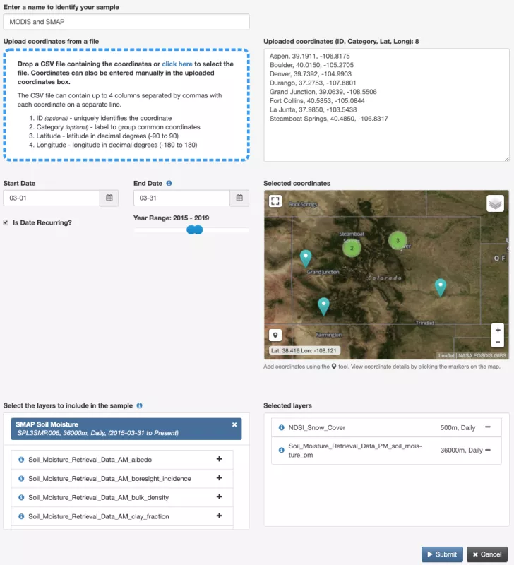
Choose Start a new request and fill in the data submission details
- Name your project
- Start Date and End Date (click the Is Data Recurring box and adjust the Year Range to receive data from one time period but spanning multiple years
- Select data layers (this tutorial uses NDSI_Snow_Cover from MODIS and Soil_Moisture_Retreival_PM_soil_moisture_pm from SMAP)
- Add or upload latitude and longitude coordinates (or copy/paste the following)
- Aspen, 39.1911, -106.8175
- Boulder, 40.0150, -105.2705
- Denver, 39.7392, -104.9903
- Durango, 37.2753, -107.8801
- Grand Junction, 39.0639, -108.5506
- Fort Collins, 40.5853, -105.0844
- La Junta, 37.9850, -103.5438
- Steamboat Springs, 40.4850, -106.8317
Step 4: Explore results
In the Explore tab, choose View the contents of the request and explore the visuals and graphs of your data submission
Step 6: Download data
In the Explore tab, choose Download Point Sample to download project statistics and native data related to the project
For questions related to NSIDC DAAC data please contact nsidc@nsidc.org. For AppEEARS related questions, contact lpdaac@usgs.gov.


