The National Snow and Ice Data Center (NSIDC) is part of the Cooperative Institute for Research in Environmental Sciences at the University of Colorado Boulder. NSIDC scientists provide Arctic Sea Ice News & Analysis content, with partial support from NASA.
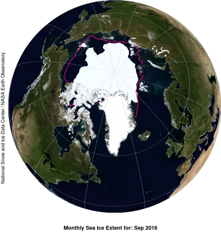
BOULDER, Colo.—At the end of its melt season Arctic sea ice extent stood at second lowest in the daily average and fifth lowest in the monthly average, according to scientists at the National Snow and Ice Data Center at the University of Colorado Boulder.
Sea ice extent retreated to 4.14 million square kilometers (1.60 million square miles) on September 10, then grew rapidly. At the end of the month, sea ice extent averaged 4.72 million square kilometers (1.82 million square miles).
This year’s minimum extent statistically tied with the 2007 minimum, when Arctic sea ice extent was measured at 4.15 million square kilometers (1.60 million square miles) on September 18.
After the 2016 minimum was reached, ice extent increased rapidly, resulting in this year’s September monthly average being the fifth lowest in the satellite record. Through 2016, monthly average September Arctic sea ice extent has declined at a rate of 13.3 percent per decade. The ten lowest September ice extents over the satellite record have all occurred in the last ten years.
The winter of 2015/2016 was extremely warm over the Arctic Ocean, setting the stage for a possible record low September minimum. However, cool, stormy weather prevailed over the Arctic Ocean from June to August.
Despite the generally unfavorable weather conditions, on 10 September, Arctic sea ice extent reached a seasonal minimum of 4.14 million square kilometers (1.60 million square miles).
“The 2016 melt season started with a lot of fairly thin ice,” noted NSIDC scientist Julienne Stroeve. “This may help to explain why, despite summer weather unfavorable to sea ice loss, extent at the seasonal minimum ended up tied for second lowest.”
The cause for the rapid rate of ice growth after the seasonal minimum remains to be fully assessed, but according to NSIDC director Mark Serreze, “The evidence suggests that once the minimum was reached, there wasn’t much heat left on the topmost layer of the ocean, so it only took a little bit of cooling for ice to form.”
Arctic sea ice cover grows each autumn and winter as the sun sets for several months, and shrinks through spring and summer. Each year, Arctic sea ice reaches its minimum extent in September. The downward trend in the extent of summer sea ice influences how much sunlight is reflected versus absorbed, which in turn affects climate. The loss of summer ice is affecting Arctic ecosystems and is making the region more accessible to shipping and other activities.
In the Southern Hemisphere, Antarctic sea ice extent reached 18.44 million square kilometers (7.12 million square miles) on August 31, 2016. This appears to be its maximum extent for the year. This is the earliest maximum in the satellite record since 1979, and the first time the maximum has occurred in August. This is 240,000 square kilometers (93,000 square miles) greater than the average extent for this date of 18.20 million square kilometers (7.03 million square miles). Despite recent years with record maximum extents in the Antarctic, this year is the tenth lowest Antarctic maximum extent on the satellite record.
NSIDC scientists said an intense wind pattern that spanned nearly half of the continent from the Wilkes Land area to the Weddell Sea in September contributed to the early Antarctic maximum. Stronger than average low pressure in this area, coupled with high pressure near the Falkland Islands in the southern Atlantic, and near the southern tip of New Zealand in the Pacific Ocean, created two regions of higher northwesterly winds.
See the full analysis on NSIDC’s Arctic Sea Ice News and Analysis page.
Media Contact
Natasha Vizcarra
National Snow and Ice Data Center
press@nsidc.org, +1 303 492 1497
