The National Snow and Ice Data Center (NSIDC) is part of the Cooperative Institute for Research in Environmental Sciences at the University of Colorado Boulder. NSIDC scientists provide Sea Ice Today content, with partial support from NASA.
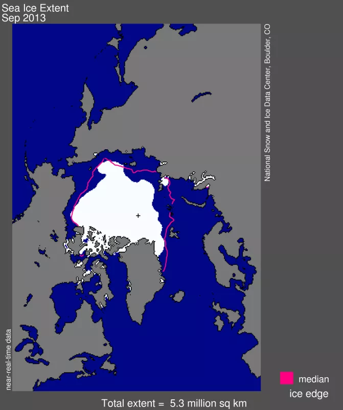
This September, sea ice covering the Arctic Ocean fell to the sixth lowest extent in the satellite record, which began in 1979. All of the seven lowest extents have occurred in the last seven years, since 2007. Satellite data analyzed by NSIDC scientists showed that the sea ice cover reached its lowest extent on September 13. Sea ice extent averaged for the month of September was also the sixth lowest in the satellite record.
"A relatively cool and stormy summer helped slow ice loss compared to the last few summers," said NSIDC scientist Julienne Stroeve. In contrast to 2012, when sea ice reached a new record low in the satellite record, cooler conditions in the Arctic this summer helped to retain more sea ice. "This summer's extent highlights the complex interaction between natural climate variability and long-term thinning of the ice cover," Stroeve said.
"For Earth's ice and snow cover taken as a whole, this year has been a bit of a bright spot within a long-term sobering trend," said NSIDC director and senior scientist Mark Serreze.
Arctic sea ice, however, continues to be thinner than in past years, as confirmed by direct satellite observations and estimates of ice age, and therefore more vulnerable to breakup by storms, circulating currents, and melt. "While Earth's cryosphere, that is, its snow and ice cover, got a shot of hope this year, it's likely to be only a short-term boost," Serreze said. While most of the ice cover now consists of young, thin ice, a pack of multiyear ice remains in the central Arctic. Multiyear ice is ice that has survived more than one melt season and is thicker than first-year ice.
Arctic sea ice extent reached its lowest point this year on September 13, 2013 when sea ice extent dropped to 5.10 million square kilometers (1.97 million square miles). Averaged over the month of September, ice extent was 5.35 million square kilometers (2.07 million square miles). This places 2013 as the sixth lowest ice extent, both for the daily minimum extent and the monthly average. September ice extent was 1.17 million square kilometers (452,000 square miles) below the 1981 to 2010 average.
The Arctic ice cap grows each winter as the sun sets for several months and shrinks each summer as the sun rises higher in the northern sky. Each year the Arctic sea ice reaches its annual minimum extent in September. It hit a new record low in 2012. This summer's low ice extent continued the downward trend seen over the last thirty-four years. Scientists attribute this trend in large part to warming temperatures caused by climate change. Since 1979, September Arctic sea ice extent has declined by 13.7 percent per decade. Summer sea ice extent is important because, among other things, it reflects sunlight, keeping the Arctic region cool and moderating global climate.
In addition to the decline in sea ice extent, a two-dimensional measure of the ice cover, the ice cover has grown thinner and less resistant to summer melt. Recent data on the age of sea ice, which scientists use to estimate the thickness of the ice cover, shows that the youngest, thinnest ice, which has survived only one or two melt seasons, now makes up the majority of the ice cover.
As the Arctic was reaching its minimum extent for the year, Antarctic sea ice was reaching record high levels, culminating in a Southern Hemisphere winter maximum extent of 19.47 million square kilometers (7.52 million square miles) on September 22. The September 2013 monthly average was also a record high, at 19.77 million square kilometers (7.63 million square miles) slightly higher than the previous record in 2012. Scientists largely attribute the increase in Antarctic sea ice extent to stronger circumpolar winds, which blow the sea ice outward, increasing extent.
In contrast to the sharp downward trend in September Arctic sea ice, Antarctic September sea ice has been increasing at 1.1 percent per decade relative to the 1981 to 2010 average. "The tiny gain in Antarctica's ice is an interesting puzzle for scientists," said NSIDC lead scientist Ted Scambos. "The rapid loss of ice in the Arctic should be ringing alarm bells for everyone."
Information and graphics
For the full analysis of the summer melt season and additional images, please see Sea Ice Today.
