By Brigitta Rongstad
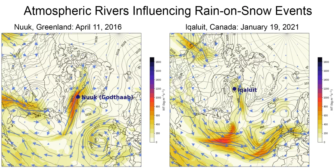
In April 2016, a warm front approached southwest Greenland, causing air temperatures in the capital city of Nuuk and the surrounding area to increase rapidly. A cold front formed nearby and the two air masses collided, creating a steep pressure gradient in the atmosphere that helped funnel moisture in from the Atlantic Ocean. And then, heavy rain fell on the early spring snowpack—and slush avalanches began.
More than 800 slush avalanches were triggered by the 2016 mid-April rain on snow event in southwestern Greenland. An unmanned surface observation station was destroyed during the event, on the day with the warmest temperatures and largest amount of rain.
A similar set of circumstances led to a rain on snow event in Svalbard in 2012. Heavy rain from an atmospheric river, a long, narrow corridor of water vapor in the atmosphere, triggered avalanches and disrupted air travel. Then temperatures dropped and ice formed on top of the snow, and reindeer were left without access to their food beneath the snow.
So, why do these extreme precipitation events happen? And where does all the moisture come from? The answers can’t always be found in the Arctic.
“Over the past winter, people have become more familiar with atmospheric rivers. We’ve seen the effects over California,” said Mark Serreze, director of the National Snow and Ice Data Center (NSIDC) and project lead for the Arctic Rain on Snow Study (AROSS). “But we’re only beginning to uncover the links between atmospheric rivers and extreme precipitation events in the Arctic.”
Now, the AROSS team is uncovering how meteorological phenomena connected to the tropics and subtropics, like atmospheric rivers, lead to rain on snow and other extreme precipitation events in the Arctic, and how these impact wildlife and people.
Atmospheric rivers ferry moisture to the Arctic
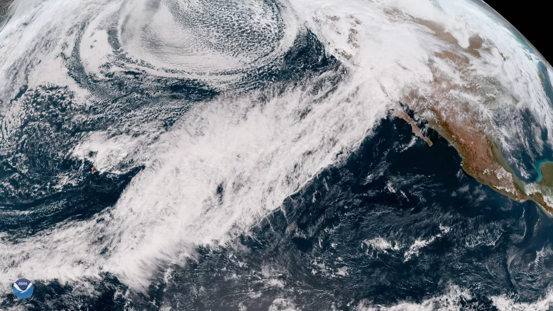
Atmospheric rivers transport large amounts of water vapor from one place to another. They originate in the tropics and subtropics when extratropical cyclones draw water from the ocean through evaporation enhanced by strong winds in the lower levels of the atmosphere. As the cyclones move poleward, moisture is carried along, leaving a “footprint” or river of water behind. Once formed, an atmospheric river can be pulled in by another cyclone and then traded to another, and so on, altering its path.
On average, an atmospheric river carries more than double the amount of water that flows through the Amazon River. And when atmospheric rivers are forced upward, either through rising motion occurring in an extratropical cyclone’s warm sector (the region ahead of the cold front) or by making landfall over complex terrain, they can generate heavy amounts of precipitation.
Along with atmospheric rivers, NSIDC scientists are also discovering that the wet remains of hurricanes can sometimes make it all the way to southern Greenland.
When it rains on snow in the Arctic, it pours
Rain isn’t a new phenomenon in the Arctic. But when it happens in the winter or during the transitional periods of fall and spring, when it should be snowing, the impacts can be devastating.
For example, in September 2022, the remnants of Hurricane Fiona, which started its journey as a tropical depression at the boundary of the Caribbean Sea and the Atlantic Ocean, brought a surge of rain to Greenland. The storm hit during an unusually warm and wet September—a time when snowfall is typically beginning to cover the edge of the ice sheet—setting off a large, late-season melting event.
When atmospheric rivers make landfall and drop rain on existing snow, like in Svalbard in 2012 and in Greenland in 2016, they can trigger slush avalanches, melting, and permafrost warming, and leave behind a thick layer of ice that cuts reindeer and other ungulates off from their food source. Evidence from Antarctica also suggests that strong atmospheric rivers can weaken ice shelf stability.
“We’re trying to catch up on how atmospheric rivers get to the Arctic, how strong they can be, how they impact extreme precipitation/rain on snow events, and whether we’ll see more of them in the future,” said Serreze.
And as the AROSS team digs into more and more extreme precipitation events, the picture is getting clearer.
Ingredients for extreme precipitation events in the Arctic
Examining historical data from nine meteorological stations and a weather forecast model, the AROSS team found that extreme precipitation events in the Canadian Arctic are generally more likely when strong cyclones are present. One event was associated with a cyclone that originated in northern Mexico. Another common thread was that each extreme precipitation event was associated with significant moisture transport, sometimes associated with atmospheric rivers.
The apparent link between atmospheric rivers and extreme precipitation events led the AROSS team to dig in further. When they zoomed in on rain on snow events, specifically, they found atmospheric rivers played a role in two rain on snow events—one, with significant impacts, near Nuuk, Greenland in 2016, and another, less severe, in the community of Iqaluit, Nunavut, Canada in 2021.
“I got to use a lot of the tools I used as a forecaster to explore the processes going on in the whole atmosphere, like using weather balloon data and surface observations,” said Jessica Voveris, a former CU Boulder graduate student and AROSS team member who led the investigation into the two rain on snow events.
And with those tools, the team was able to link the rain on snow events to specific meteorological phenomena—mainly atmospheric “blocking” structures, which inhibit the movement of cyclones and storms, and atmospheric rivers.
“If we understand the set-up for rain on snow events, it can help us better engage and communicate with the public—from helping forecasters recognize these weather patterns to collaborating with community planners or emergency management personnel,” said Voveris.
As the climate warms, the Arctic is expected to experience more precipitation, with the proportion of rain to snow increasing. But the influence of climate change on atmospheric rivers, and their impact on rain on snow events, remains unclear.
“We’re in the midst of a great global experiment, and we don’t quite know how things are going to end up,” said Serreze. “Atmospheric rivers depend on atmospheric circulation and cyclones—and these are also changing. Given the known impacts in the Arctic, it behooves us to learn more.”
Linking AROSS research with community observations

Community knowledge is critical for understanding how rain on snow and other extreme precipitation events impact Arctic peoples. Vital climate information recorded by volunteers in local observer networks, like the Local Environmental Observer (LEO) Network, provides the AROSS team with a “boots on the ground” view of extreme events. But sometimes, what the meteorology shows and what local people see and feel are not the same.
“What is identified as an extreme event in meteorological terms may differ from what is viewed as an extreme event by Arctic communities,” said Taylor O’Brien, a CU Boulder graduate student and AROSS team member. “I’m researching if there are identifiable patterns, to better predict these events and how they will impact communities and animals.”
O’Brien is just diving into her work. Over the next year, she will look at how events recorded in the LEO network map onto atmospheric conditions. Cyclones and atmospheric rivers are just one piece of the puzzle.
“We have the meteorological data. We have reanalyses to look at the formation and how [atmospheric rivers] travel to the Arctic,” said Serreze. “But the impact side is harder to uncover. And that’s what we’re working on now because this is what really matters to the peoples of the north.”


