By Michon Scott
As they grind over rocky landscapes, glaciers produce their own kind of sediment, known as glacial till. Glaciers push glacial sediment around all the time, sometimes piling it up in front of the glacier's lower end, or snout, or off to the side, forming moraines.
Sediment can end up riding on top of the glacier, too, as supraglacial debris. This glacier-riding debris might result from the erosion of surrounding rocks, whose debris is carried to the glacier’s surface by avalanches of rock and snow. In fact, many glacier surfaces become the sites of ongoing contests between snow accumulation and debris accumulation.
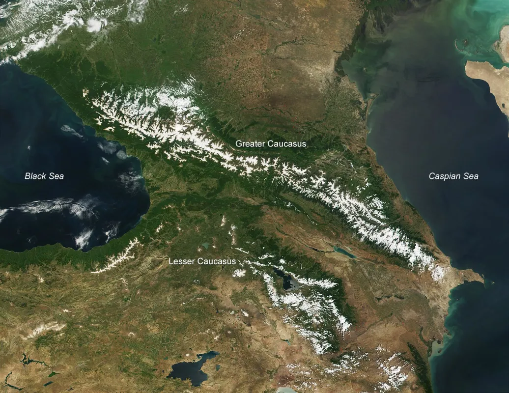
One place where debris might tell a story worth watching is the Caucasus: the mountainous region stretching between the Black Sea in southeastern Europe and farther east to the Caspian Sea. A newly published study has mapped glacial debris across the Greater Caucasus. The new study found an increasing trend in glacial debris between 2014 and 2020. The authors relied in part on the Global Land Ice Measurements from Space (GLIMS) data set available from the National Snow and Ice Data Center NASA Distributed Active Archive Center (NSIDC DAAC).
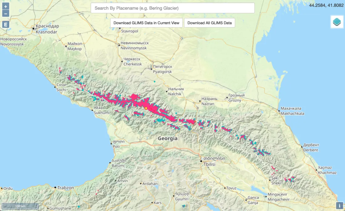
GLIMS and its viewer
Earth has roughly 200,000 glaciers, and Global Land Ice Measurements from Space (GLIMS) provides data on nearly all Earth’s mountain glaciers and ice caps outside Antarctica and Greenland. GLIMS is an international project that identifies glaciers and makes the resulting database available to those who need it. The database incorporates observations not only on glaciers but also the lakes and rock debris layers sitting on top of them.
The GLIMS database is assembled largely from satellite images, such as the Satellite Pour l’Observation de la Terre (SPOT), the Advanced Spaceborne Thermal Emission and Reflection Radiometer (ASTER) instrument aboard NASA’s Terra satellite, and the Landsat Enhanced Thematic Mapper Plus (ETM+). These satellite sensors collect high-resolution images. ASTER imagery, for instance, can reach a resolution as high as 15 square meters (160 square feet) per pixel.
The GLIMS project relies on repeat surveys by satellite sensors, and draws from aerial photography, maps, and historical observations, some dating back to the mid-nineteenth century. GLIMS offers more than data files. It also provides an easy-to-use viewer available through any web browser.
Why glacial debris matters
Sediment debris can have a major effect on the glacier it occupies. For starters, debris may affect glacier melt. A very thin layer of sediment, typically darker than snow or ice, reduces the amount of light reflected by the glacier surface. Consequently, the glacier soaks up more of the Sun’s warmth and melts faster. If a layer of debris is thick enough, however, it may serve as insulation, slowing the glacier’s melt and evaporation.
The interaction between glaciers and debris matters in part because mountain glaciers have good and bad relationships with humans and wildlife. Slow-melting glaciers feed streams and rivers, providing water for plants, animals, and people, particularly during dry spells. But glaciers and glacial debris pose hazards as well. For instance, glacial outburst floods—glacial lakes breaking through rock or ice dams and inundating areas below—can prove deadly to anyone and anything in the water’s path. Accumulated glacial debris might tumble downslope in rockfalls. So, debris riding on top of a glacier can heighten the risk of geohazards. Debris can also impede scientists’ ability to study glaciers by blurring the boundaries between the individual ice bodies.
When temperatures rise and precipitation declines over a long enough stretch of time, the proportion of glaciers covered by debris cover is likely to increase. This might be happening across the Greater Caucasus.
The role of glaciers in the Greater Caucasus
The Greater Caucasus might not spring to mind when one thinks of the world’s glacier-rich mountainous regions, but the region has its share of mountains and slow-moving rivers of ice. The mountain range stretches roughly 1,100 kilometers (700 miles) across parts of Georgia, Russia, and Azerbaijan, and the range contains some 200 peaks over 4,000 meters (13,000 feet) above sea level.
One of two mountain ranges in the region, the Greater Caucasus, is situated north of the less expansive Lesser Caucasus. The Greater Caucasus is characterized by a steep southern slope and a long, gentle northern slope. Temperature and precipitation vary by geography and season, driven by differences in landscape and prevailing weather patterns. Depending on the time of year and location, parts of the range might get cold air from the Arctic, dry and dusty air from the Middle East, and humid air from the Mediterranean. Most of the precipitation arrives in early summer, thanks to Atlantic cyclones.
The Greater Caucasus serves as a watershed for the Black Sea (via the Rioni and the Inguri Rivers), the Caspian Sea (via the Sulak, Terek, and Kuma Rivers), and the Sea of Azov (via the Kuban River). Annual melt of snow and ice kicks off a flood cycle in parts of the Greater Caucasus that might endure for months. Cooler temperatures at higher elevations in the region means some precipitation falls primarily as snow.
Snow accumulation over many years can make a glacier, but since the end of the Little Ice Age, from roughly 1350 to 1850, temperatures in this region have increased, leading to glacier declines. Since the 1980s, the 2024 study authors reported, glacier declines have steepened. The glaciers have been affected by a combination of rising temperatures and declining snowfall. Average monthly temperatures in the region have increased up to 1.0°C (1.8°F) since the start of the twenty-first century.
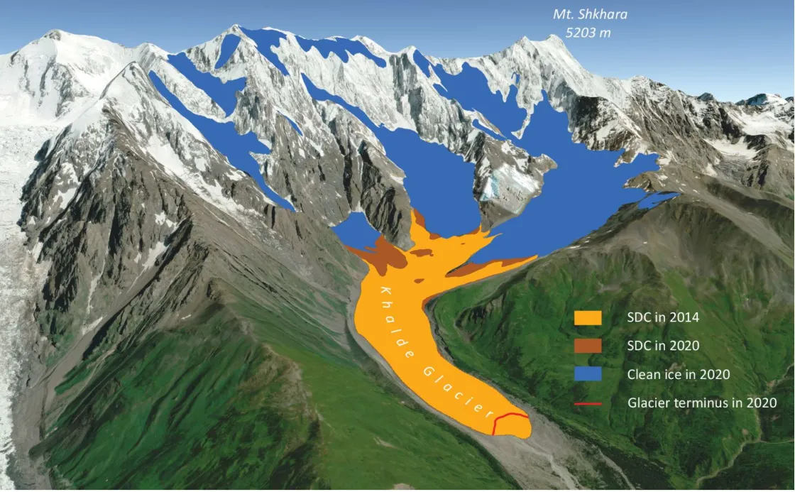
The Greater Caucasus study authors pointed to this combination as the explanation for the rising trend in supraglacial debris from 2014 to 2020. By 2020, debris covered about 10 percent of the glacier surface. Glaciers melt and evaporate away in warmer, drier conditions, but glacial debris remains. Even worse, rising temperatures can lead to permafrost thaw and slope failures along glacier margins, dumping even more debris onto glacier surfaces.
How GLIMS advanced this study
The Greater Caucasus study authors relied on multiple tools, including observations from multiple satellites, and a toolbox known as DebCovG-carto, whose name refers to debris-covered glaciers and cartography. The DebCovG-carto toolbox incorporates information on mountain slopes, vegetation, and ice and snow, among other factors.
The study authors, who are foremost among the contributors to GLIMS data for the Caucasus region, employed those data in the new study. The researchers used an automated extraction process to pull individual glacier shapefiles, followed by quality control to guard against gaps and overlaps in the data. GLIMS’s inclusion of glacier boundaries overcomes one of the growing challenges in the Greater Caucasus, where increasing supraglacial debris can obscure those boundaries. GLIMS use of repeat surveys and historical sources, supplemented by human interpretation where needed, provides a comparatively reliable source of glacial outlines.
By relying on GLIMS and other data sources, the study authors not only identified an overall increasing trend in supraglacial debris, but also found differences in the prevalence of debris in different parts of the Greater Caucasus. Debris cover was lowest in the west, at approximately 7.1 percent, and much higher in the east, at about 18.0 percent. Study authors suggested that differences in weather patterns and local geology, with some areas more susceptible to local rock erosion, could account for the differences.
Access data through the NSIDC DAAC
NASA’s NSIDC DAAC manages, distributes, and supports a variety of cryospheric and climate-related datasets as one of the discipline-specific Earth Science Data and Information System (ESDIS) data centers within NASA’s Earth Science Data Systems (ESDS) Program. User Resources include data documentation, help articles, data tools, training, and on-demand user support. Learn more about NSIDC DAAC services.
References
Hewitt, K. 2005. The Karakoram Anomaly? Glacier expansion and the ‘elevation effect,’ Karakoram Himalaya. Mountain Research and Development 25(4): 332-340. https://doi.org/10.1659/0276-4741(2005)025[0332:TKAGEA]2.0.CO;2
Scherler, D., H. Wulf, and N. Gorelick. Global assessment of supraglacial debris-cover extents. Geophysical Research Letters 45:11798-11805. https://doi.org/10.1029/2018GL080158
Tielidze, L.G., G. Iacob, and I. Horia Holobâcă. 2024. Mapping of supra-glacial debris cover in the Greater Caucasus: A semi-automated multi-sensor approach. Geosciences 14: 178. https://doi.org/10.3390/geosciences14070178


