By Jane Beitler
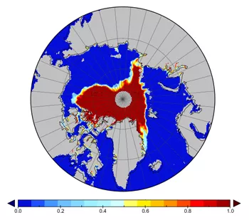
The rising interest in Arctic sea ice is the inverse of its decline: less ice equates to more demand for reliable data on sea ice conditions. But with decades of data from multiple satellite sensors and multiple research groups, where do researchers turn for the most reliable long-term view? In answer, NSIDC has produced a Climate Data Record for sea ice concentration, an important indicator of sea ice health and Arctic climate.
The demand for data
The National Research Council (NRC) defines a Climate Data Record (CDR) as a time series of measurements of sufficient length, consistency, and continuity to determine climate variability and change. Because of the strong decline in Arctic sea ice, a signal of climate warming, some of NSIDC’s most used products are sea ice records from passive microwave remote sensing instruments on U.S. Defense Meteorological Satellite Program (DMSP) satellites.
These products provide ice concentration and extent information since late 1978, based on two algorithms developed by scientists at the NASA Goddard Space Flight Center (GSFC). Each algorithm utilizes scientific expertise to manually pull out spurious areas of ice, and the resulting data products have different strengths and weaknesses. For example, the NASA Team data product is more accurate where surface temperatures are very cold; the Bootstrap data product does a better job where ice is melting. Like many climate data sets, the sea ice concentration products were developed and processed by individual researchers or research groups for use within the scientific community studying sea ice. These expert users knew how to appropriately use the data, and understood the limitations of the data. However, as interest in sea ice data (and climate data in general) has increased, there is a much broader community of users: researchers in other areas of climate, modelers, biologists, ecologists, sociologists, civilian and military government planners, educators, students, journalists, bloggers, and the general public. These users are not familiar with the science behind the data or the subtleties of different data sets. As a result, they may not understand the limitations of the data, and can easily misuse the data.
Setting the record straight
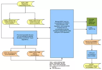
When NSIDC set out to produce a CDR for sea ice concentration under NOAA's CDR program, the intent was to blend the current NASA GSFC products into the combined CDR. As NSIDC examined the blended product, it became clear that it would not meet NOAA's requirement to be transparent and reproducible. So NSIDC created a new data product by reprocessing the original satellite data with both the NASA Team and Bootstrap algorithms, adding several features to meet CDR criteria.
First, the processing is fully automated and documented, with processing code available from the NOAA CDR program. Second, the data are provided in a self-describing file format (NetCDF4) that contains complete Climate and Forecasting (CF1.5) metadata. Finally, the data include fields that indicate data quality or uncertainty for each concentration measurement. The new sea ice CDR was recently made available to users. The CDR provides a consistent, daily time series of sea ice concentrations from 09 July 1987 through 31 December 2007. Data are in the same polar projection and grid size as the previous NSIDC and NASA data sets. The original NASA data sets are also provided for reference. Additional years of data will be released as processing permits.
Access the NOAA/NSIDC Climate Data Record of Passive Microwave Sea Ice Concentration.
This work was supported by the NOAA Climate Data Record program, grant #NA08OAR4320914.
The NASA Distributed Active Archive Center (DAAC) at NSIDC provided input data sets to the CDR effort under NASA contract NNG08HZ07C.

