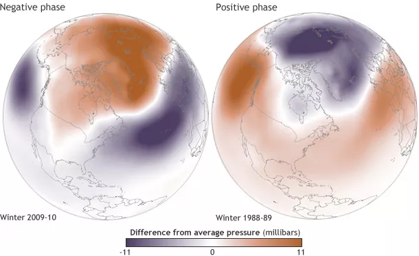
Like El Niño and La Niña, the Arctic Oscillation (AO) is a big-picture of atmospheric conditions that influence weather. The AO, which alternates between two distinct modes, describes how pressure patterns are distributed over the Arctic region and the middle latitudes of the Northern Hemisphere. NSIDC director Mark Serreze, an expert on Arctic climate and weather, said, “When the Arctic Oscillation flips from one mode to another, that represents a fundamental change in the circulation of the atmosphere, the way the winds blow.”
The AO’s seesaw pattern of changing conditions affects the Northern Hemisphere polar vortex, which is a region of cold air rotating from west to east. The polar vortex does not come and go; it is a permanent feature of the Earth system. Still, the vortex’s shape changes over time, affected by shifts in atmospheric pressure and temperature. Scientists describe these pressure and temperature shifts as changes in the AO.
The basics of pressure
At times, the difference in pressure between the middle latitudes and a polar region is stark. At other times, the difference is less pronounced. When the difference is strong, the AO is in positive mode. When the difference is less strong, the AO is in its negative mode. The AO can persist in either phase anywhere from days to months.
Pressure differences manifested in the AO affect Earth’s atmosphere and people’s lives, particularly in winter. “When the Arctic Oscillation is in its positive phase, the jet stream, which brings us much of our weather in middle latitudes, tends to shift to the north,” Serreze said. When the AO is in positive mode, the polar vortex is generally a neat, tight circle, with cold air and contemptible winter storms sent into timeout far away from civilization. When the AO is in negative mode, the vortex is wavier, and unruly weather can run amok, setting snowfall records.
The AO was in negative mode in February 2010 when weird winter storms dumped 55.9 inches of snow at Reagan National Airport, and 79.9 inches at Baltimore-Washington Airport. While mid-Atlantic residents shoveled away a mountain of snow, Vancouver residents marveled at their warmest January to date.
While the AO is powerful, it is not a sole actor. NSIDC scientist Walt Meier noted that the AO often influences weather by working in concert with other large-scale patterns, such as El Niño and La Niña.
AO and sea ice
Climate scientists also observe how the AO influences sea ice conditions in the Arctic Ocean. Over the long term, sea ice extent has been declining. However, during any particular winter, extent can vary because of weather conditions. Meier said, “The Arctic Oscillation primarily affects sea ice through winds that cause changes in where the sea ice drifts.” When the Arctic Oscillation is in its negative mode, the winds and ice tend to flow in a clockwise direction, generally keeping more of the older, thicker ice in the middle of the Arctic. In the positive phase, that old ice tends to get pushed out of the Arctic along the Greenland coast. Meier said, “This means that the sea ice tends to be younger and thinner and more prone to melt after a winter with a strong positive Arctic Oscillation.”
To see the current graph of the AO phase, visit the NOAA National Weather Service Climate Prediction Center Web page.
