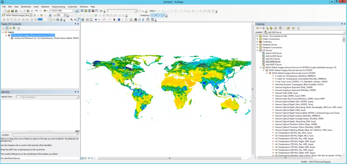
Visualize NSIDC data as WMS layers with ArcGIS and Google Earth
NASA's Global Imagery Browse Services (GIBS) provides up to date, full resolution imagery for selected NSIDC DAAC data sets. Adding GIBS layers via OGC methods, such as Web Map Service (WMS), Web Map Tile Service (WMTS) and Tiled Web Map Service (TWMS) provides an easy way to visualize the entire time series of these data in commerical tools like ArcGIS and Google Earth.
AMSR-E GIBS data
| Data set | Data set parameter | GIBS parameter |
|---|---|---|
| 89.0H_Res.5B_TB_(not-resampled) | Brightness Temperature (89H GHz B Scan, Day) | |
| 89.0H_Res.5B_TB_(not-resampled) | Brightness Temperature (89H GHz B Scan, Night) | |
| 89.0V_Res.5B_TB_(not-resampled) | Brightness Temperature (89V GHz B Scan, Day) | |
| 89.0V_Res.5B_TB_(not-resampled) | Brightness Temperature (89V GHz B Scan, Night) | |
| SI_06km_NH_89H_DAY, SI_06km_SH_89H_DAY | Sea Ice Brightness Temperature (89H GHz B Scan) | |
| SI_06km_NH_89V_DAY, SI_06km_SH_89V_DAY | Sea Ice Brightness Temperature (89V GHz B Scan) | |
| SI_12km_NH_ICECON_DAY, SI_12km_SH_ICECON_DAY | Sea Ice Concentration, 12km | |
| SI_12km_NH_SNOWDEPTH_5DAY, SI_12km_SH_SNOWDEPTH_5DAY | Snow Depth Over Ice, 12km | |
| AE_SI25 | SI_25km_NH_ICECON_DAY, SI_25km_SH_ICECON_DAY | Sea Ice Concentration, 25km |
| surfaceRain | Surface Rain Rate (Day) | |
| surfaceRain | Surface Rain Rate (Night) | |
| surfacePrecipitation | Surface Precipitation Rate (Day) | |
| surfacePrecipitation | Surface Precipitation Rate (Night) |
Aquarius GIBS data
Data set | Data set parameter | GIBS parameter |
|---|---|---|
I3m_data | Soil Moisture (Daily, Radiometer | |
I3m_data | Soil Moisture (Weekly, Radiometer |
MEaSUREs GIBS data
| Data set | Data set parameter | GIBS parameter |
|---|---|---|
| nsidc-0477 | FT_status | Freeze/Thaw (Daily Landscape) |
| nsidc-0478 | Ice Velocity (Greenland) | |
| nsidc-0484 | Ice Velocity (Antarctica) | |
| nsidc-0534 | Sea Ice and Snow Extent |
MODIS GIBS data
| Data sets | Data set parameter | GIBS parameter |
|---|---|---|
| MOD10_L2 & MYD10_L2 | NDSI_Snow_Cover | Snow Cover (Normalized Difference Snow Index) |
| MOD10A1 & MYD10A1 | NDSI_Snow_Cover | Snow Cover (Normalized Difference Snow Index, L3, Daily) |
| MOD10A2 & MYD10A2 | Maximum_Snow_Extent | Snow Extent (L3, 8-Day) |
| MOD10CM & MYD10CM | Snow_Cover_Monthly_CMG | Days with Snow Cover (L3, Monthly, Average Percent) |
| MOD29 & MYD29 | Sea_Ice_by_Reflectance Ice_Surface_Temperature | Sea Ice, Ice Surface Temperature (Day), and Ice Surface Temperature (Night) |
| MOD29P1N & MYD29P1N | Ice_Surface_Temperature | Ice Surface Temperature (L3, Daily, Night) |
SMAP GIBS data
| Data set | Data set parameter | GIBS parameter |
|---|---|---|
| cell_tb_h_fore | Uncorrected Brightness Temperature 9 km (L1, Passive, Fore, H Polarization) | |
| cell_tb_h_aft | Uncorrected Brightness Temperature 9 km (L1, Passive, Aft, H Polarization) | |
| cell_tb_v_fore | Uncorrected Brightness Temperature 9 km (L1, Passive, Fore, V Polarization) | |
| cell_tb_v_aft | Uncorrected Brightness Temperature 9 km (L1, Passive, Aft, V Polarization) | |
| cell_tb_qual_flag_h_fore | Uncorrected Brightness Temperature 9 km RFI (L1, Passive, Fore, H Polarization) | |
| cell_tb_qual_flag_h_aft | Uncorrected Brightness Temperature 9 km RFI (L1, Passive, Aft, H Polarization) | |
| cell_tb_qual_flag_v_fore | Uncorrected Brightness Temperature 9 km RFI (L1, Passive, Fore, V Polarization) | |
| cell_tb_qual_flag_v_aft | Uncorrected Brightness Temperature 9 km RFI (L1, Passive, Aft, V Polarization) | |
| cell_tb_qual_flag_h_fore | Uncorrected Brightness Temperature 9 km QA (L1, Passive, Fore, H Polarization) | |
| cell_tb_qual_flag_h_aft | Uncorrected Brightness Temperature 9 km QA (L1, Passive, Aft, H Polarization) | |
| cell_tb_qual_flag_v_fore | Uncorrected Brightness Temperature 9 km QA (L1, Passive, Fore, V Polarization) | |
| cell_tb_qual_flag_v_aft | Uncorrected Brightness Temperature 9 km QA (L1, Passive, Aft, V Polarization) | |
| cell_tb_h_fore | Uncorrected Brightness Temperature 36 km (L1, Passive, Fore, H Polarization) | |
| cell_tb_h_aft | Uncorrected Brightness Temperature 36 km (L1, Passive, Aft, H Polarization) | |
| cell_tb_v_fore | Uncorrected Brightness Temperature 36 km (L1, Passive, Fore, V Polarization) | |
| cell_tb_v_aft | Uncorrected Brightness Temperature 36 km (L1, Passive, Aft, V Polarization) | |
| cell_tb_qual_flag_h_fore | Uncorrected Brightness Temperature 36 km RFI (L1, Passive, Fore, H Polarization) | |
| cell_tb_qual_flag_h_aft | Uncorrected Brightness Temperature 36 km RFI (L1, Passive, Aft, H Polarization) |
