Data Sets for Research
Scientific Data Search
Support for Researchers
Data for Everyone
Sponsored Programs
Looking for facts and information? See About the Cryosphere.
On Thin Ice: Expedition to a Crumbling Ice Shelf
Scientists blog from Antarctica and provide a glimpse of what it's like to do research in the field. Read their blog ...
For the Media
For Data Users
Current Conditions
NSIDC In the News
Events
NSIDC Highlights
Icelights: Answers to your burning questions about ice and climate
What's hot in the news around climate and sea ice and what are scientists talking about now? Read more...
About NSIDC
About the Cryosphere
What is the Cryosphere?
When scientists talk about the cryosphere, they mean the places on Earth where water is in its solid form, frozen into ice or snow. Read more ...
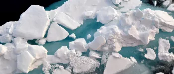
Sea ice north of Greenland. Photo Credit: Courtesy Andy Mahoney, NSIDC (View photo detail.)
Pancake photographed north of Greenland. Photo Credit: Courtesy Andy Mahoney, NSIDC (View photo detail.)
Jumpsuit Main Camp October 1972 Image Credit: NSIDC courtesy Tom Marlar/CRREL AIDJEX Web site (View photo detail.)
Pfeister's Island; March April 1974 Image Credit: NSIDC courtesy Pat Martin AIDJEX Web site (View photo detail.)
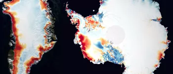
Sea ice concentration from the NSIDC Sea Ice Index. (View photo detail.)
An iceberg near Chip, the test berg, was fractured with cracks. Photo Credit: Courtesy Ted Scambos and Rob Bauer, NSIDC IceTrek Web site (View photo detail.)
This iceberg is shown for its fracturing surface features. Photo Credit: Courtesy Ted Scambos and Rob Bauer, NSIDC IceTrek Web site (View photo detail.)
This in-flight photo shows James Ross Island. Photo Credit: Courtesy Ted Scambos and Rob Bauer, NSIDC IceTrek Web site (View photo detail.)
Icebergs and sea ice melt during the southern hemisphere summer. Photo Credit: Courtesy Ted Scambos and Rob Bauer, NSIDC IceTrek Web site (View photo detail.)
Sea ice and icebergs combine to form patterns. Photo Credit: Courtesy Ted Scambos and Rob Bauer, NSIDC IceTrek Web site (View photo detail.)
The IceTrek team walksalong the coast of Seymour Island, taking in the view that Marambio Base has to offer. Photo Credit: Courtesy Ted Scambos and Rob Bauer, NSIDC IceTrek Web site (View photo detail.)
AIDJEX 1972 pilot study. Inside NASA CV990 Image Credit: National Snow & Ice Data Center AIDJEX Web site (View photo detail.)
AIDJEX 1972 pilot study. Image Credit: National Snow & Ice Data Center AIDJEX Web site (View photo detail.)
Part of the Heitronics KT-19.82 thermal radiometer, mounted to the port side rail of the Aurora Australis, to measure the skin temperature of the sea ice. Photo Credit: Courtesy Ted Scambos, NSIDC (View photo detail.)
An aerial view of an example of rafted nila. Photo Credit: Courtesy Alice O'Connor (View photo detail.)
One of several teams aboard the Aurora Australis, being lowered in the basket so that can start their research. Photo Credit: Courtesy Ted Scambos, NSIDC (View photo detail.)
An aerial view of the Aurora Australis breaking through the sea ice surrounding it, noted to be smooth snow-covered sea ice. Photo Credit: Courtesy Alice O'Connor (View photo detail.)
The iceberg seen on the ARISE Cruise, surrounded by cake ice in the background. Photo Credit: Courtesy Paul Endersby (View photo detail.)
The moon as seen from the Antarctic waters along the ARISE Cruise. Photo Credit: Courtesy Rachel Marsh (View photo detail.)
A view stretching out over the Antarctica sea ice from the bridge. Courtesy Ted Scambos, NSIDC (View photo detail.)
An airborne view of the nila breaking away from the smooth snow-covered sea ice. Courtesy Ted Scambos, NSIDC (View photo detail.)
The iceberg seen on the ARISE Cruise, surrounded by cake ice. Photo Credit: Courtesy Paul Endersby (View photo detail.)
During the ARISE Cruise, the team came across several icebergs; this one in particular struck a fancy due to its unusually broken shape, strutting up through the sea ice as a part of the sheet.Courtesy Ted Scambos, NSIDC (View photo detail.)
An above view of the edge of the smooth snow-covered sea ice, which broken pieces floating off. Photo Credit: NSIDC Courtesy Anthony Petty (View photo detail.)
The "chain gang" hard at work, drilling into the sea ice and taking samples for their research. Photo Credit: NSIDC Courtesy Anthony Petty (View photo detail.)
While out in the field, the crew had some feathered bystanders (emperor penguins) watching from an unusually close distance. Photo Credit: Courtesy Ted Scambos, NSIDC (View photo detail.)
An artistic shot taken of the surface of smooth-covered sea ice disappearing into the Antarctic light. Photo Credit: NSIDC Courtesy Alice O'Connor (View photo detail.)
An above view of one of the holes drilled to take ice core samples during the research on the sea ice. Photo Credit: NSIDC Courtesy Erica Key (View photo detail.)
The team is ready to embark out onto the sea ice for a day of field work. Photo Credit: Courtesy Ted Scambos, NSIDC (View photo detail.)
Along the Antarctic Remote Ice Sensing Experiment (ARISE), the team came across some native Antarctic wildlife; pictured here is the crabeater seal. Photo Credit: NSIDC Courtesy Paul Endersby (View photo detail.)
Terry Haran (center, middleground) drilling core samples with the team. Photo Credit: Courtesy Ted Scambos, NSIDC (View photo detail.)
At the end of a work day for the team, all that are left behind are markers and snow-tracks. Photo Credit: NSIDC Courtesy Vicky Lytle (View photo detail.)
Terry Haran drilling core samples with the team. Photo Credit: Courtesy Ted Scambos, NSIDC (View photo detail.)
Detailed image of the edge of an iceberg and/or possibly sea ice. Photo Credit: NSIDC Courtesy Erica Key (View photo detail.)
A few emperor penguins hanging around the camera while the team is hard at work in the field. Photo Credit: Courtesy Ted Scambos, NSIDC (View photo detail.)
One of several aerial shots taken on the day of the 17th of October from the AS350 Squirrel, specifically a distinctive fracture line through a sheet of sea ice. Photo Credit: Courtesy Ted Scambos, NSIDC (View photo detail.)
One of the ice floes encountered along the ARISE Cruise. Photo Credit: Courtesy Ted Scambos, NSIDC (View photo detail.)
During the ARISE Cruise, the team came across various types of sea ice; pictured here is grease ice. Photo Credit: Courtesy Ted Scambos, NSIDC (View photo detail.)
One of the teams aboard the Aurora Australis doing field-work nearby the icebreaker. Photo Credit: NSIDC Courtesy Rodney Charles (View photo detail.)
While navigating the Ross Sea, the team came across this unusual cluster of icebergs and pancake ice. This is one of several photos taken. Photo Credit: Courtesy Ted Scambos, NSIDC (View photo detail.)
The Heitronics KT-19.82 thermal radiometer, mounted to the port side rail of the Aurora Australis, to measure the skin temperature of the sea ice. Photo Credit: Courtesy Ted Scambos, NSIDC (View photo detail.)
An airborne view of the Aurora Australis, surrounded by sea ice, specifically overlapping nila. Photo Credit: NSIDC Courtesy Alice O'Connor (View photo detail.)
The research teams often worked through the day and into the night, by the aid of the icebreaker's flood lamps. Photo Credit: NSIDC Courtesy Anthony Petty (View photo detail.)
An above view of nila sea ice from the flight on the 3rd day of October. Photo Credit: Courtesy Ted Scambos, NSIDC (View photo detail.)
An aerial view of the overlapping nila breaking off from the smooth snow-covered sea ice. Photo Credit: NSIDC Courtesy Alice O'Connor (View photo detail.)
One of several visual examples of pancake ice, otherwise known as cake ice. Photo Credit: Courtesy Ted Scambos, NSIDC (View photo detail.)
The Aurora Australis navigating through a field of pancake ice. Photo Credit: Courtesy Ted Scambos, NSIDC (View photo detail.)
An aerial view of a gathering of Adelie penguins fleeing from the helicopter above them. PhotoCredit: NSIDC Courtesy Anthony Petty (View photo detail.)
A view stretching out over the Antarctica sea ice from the port side. Photo Credit: Courtesy Ted Scambos, NSIDC (View photo detail.)
A view stretching out over the Antarctica sea ice from the bridge. Photo Credit: Courtesy Ted Scambos, NSIDC (View photo detail.)
The morning sunlight beaming down on the sea ice of Antarctica. Photo Credit: Courtesy Ted Scambos, NSIDC (View photo detail.)
The Aurora Australis breaking its way through the sea ice of the Antarctic waters. Photo Credit: NSIDC Courtesy Erica Key (View photo detail.)
During the ARISE Cruise, the team came across various types of sea ice; pictured here is silver dollar ice. Photo Credit: Courtesy Ted Scambos, NSIDC (View photo detail.)
The Antarctic sunlight illuminating the surface of the sea ice, embossing the fracture lines. Photo Credit: NSIDC Courtesy Scott Stark (View photo detail.)
An above view of the Aurora Australis breaking through the silver dollar sea ice. Photo Credit: NSIDC Courtesy Angus Munro (View photo detail.)
An excellent example of a pressure ridge on sea ice. Photo Credit: Courtesy Ted Scambos, NSIDC (View photo detail.)
The Antarctic sunlight illuminating the surface of the sea ice, intensifying the effect of the fracture lines. Photo Credit: NSIDC Courtesy Scott Stark (View photo detail.)
With the Aurora Australis at a stand still, the teams on board venture out onto the sea ice surface to do their research projects. Photo Credit: NSIDC Courtesy Alice O'Connor (View photo detail.)
Ted Scambos and Terry Haran hauling their equipment to the ice site, after having transported it off the icebreaker. Photo Credit: NSIDC Courtesy Robert Massom (View photo detail.)
A pond formed amidst the surface of the sea ice. Photo Credit: Courtesy Ted Scambos, NSIDC (View photo detail.)
Terry Haran (front) and Ted Scambos (back), hard at work on one of their ice sites. Photo Credit: NSIDC Courtesy Robert Massom (View photo detail.)
The research teams aboard the Aurora Australis conducting research out on the sea ice, with some feathered friends in keen observation (left). Photo Credit: Courtesy Ted Scambos, NSIDC (View photo detail.)
Along the Antarctic Remote Ice Sensing Experiment (ARISE), the team came across some native Antarctic wildlife; pictured here are three emperor penguins. Photo Credit: Courtesy Ted Scambos, NSIDC (View photo detail.)
Terry Haran with the Heitronics KT-19.82 thermal radiometer, mounted to the port side rail of the Aurora Australis, to measure the skin temperature of the sea icePhoto Credit: Courtesy Ted Scambos, NSIDC (View photo detail.)
The trail left behind by the Aurora Australis after navigating past the iceberg in the background. Photo Credit: NSIDC Courtesy Andi Pfaffling (View photo detail.)
While traversing the Ross Sea, the team saw Pennel Bank, shown here. Photo Credit: Courtesy Ted Scambos, NSIDC (View photo detail.)
One of several shots taken during the ARISE Cruise, off the starboard side of the icebreaker. Photo Credit: Courtesy Ted Scambos, NSIDC (View photo detail.)
An aerial view of the ice sculpture, surrounded by nilas and smooth snow-covered ice. Photo Credit: NSIDC Courtesy Alice O'Connor (View photo detail.)
An aerial view of smooth snow-covered sea ice, with fracturing on the surface. Photo Credit: NSIDC Courtesy Alice O'Connor (View photo detail.)
An airborne view of the overlapping nila blended into the smooth snow-covered sea ice, which an iceberg in the middle. Photo Credit: Courtesy Ted Scambos, NSIDC (View photo detail.)
An aerial view of smooth snow-covered sea ice, particularly noting the sastrugi on the surface. Photo Credit: NSIDC Courtesy Alice O'Connor (View photo detail.)
An in-flight view of the overlapping nila. Photo Credit: NSIDC Courtesy Alice O'Connor (View photo detail.)
An airborne view of the overlapping nila blended into the smooth snow-covered sea ice, which an iceberg at center. Photo Credit: NSIDC Courtesy Anthony Petty (View photo detail.)
One of several aerial shots taken on the day of the 18th of October from the AS350 Squirrel. Photo Credit: NSIDC Courtesy Anthony Petty (View photo detail.)
The AWI self-developed Helicopter EM Sensor in action beneath the AS350 Squirrel. Photo Credit: NSIDC Courtesy Alice O'Connor (View photo detail.)
An airborne view of the overlapping nila shifting into the smooth snow-covered sea ice. Photo Credit: NSIDC Courtesy Andi Pfaffling (View photo detail.)
The icebreaker Aurora Australis is patiently awaiting the return of the scientific teams and their equipment. Several stops similar to the one shown here were made along the expedition. Photo Credit: NSIDC Courtesy Rachel Marsh (View photo detail.)
The Aurora Australis at a stand-still while the crew spends the day in the field. Photo Credit: Courtesy Ted Scambos, NSIDC (View photo detail.)
AWI's self-developed Helicopter EM Sensor, seated on its suspension rack. Photo Credit: NSIDC Courtesy Andi Pfaffling (View photo detail.)
An aerial view of the helicopter taking data of the sea ice below. Photo Credit: Courtesy Ted Scambos, NSIDC (View photo detail.)
One of several aerial shots taken from the AS350 Squirrel. Photo Credit: NSIDC Courtesy Rob Massom (View photo detail.)
An aerial view of the helicopter taking data of the sea ice below. Photo Credit: NSIDC Courtesy Alice O'Connor (View photo detail.)
One of several aerial shots taken on the day of the 1st of October from the AS350 Squirrel. Photo Credit: NSIDC Courtesy Rachel Marsh (View photo detail.)
An airborne view of the Aurora Australis on the way back from an aerial data collection trip. Photo Credit: NSIDC Courtesy Andi Pfaffling (View photo detail.)
One of several aerial shots taken on the day of the 18th of October from the AS350 Squirrel. Photo Credit: NSIDC Courtesy Rachel Marsh (View photo detail.)
The AS350 Squirrel (VH-AFO) airborne for floe-hopping. Photo Credit: NSIDC Courtesy Tony Worby (View photo detail.)
One of several aerial shots taken from the AS350 Squirrel. Photo Credit: NSIDC Courtesy Tony Worby (View photo detail.)
One of several aerial shots taken on the day of the 1st of October from the AS350 Squirrel. Photo Credit: NSIDC Courtesy Vicky Lytle (View photo detail.)
An aerial view of one of the icebergs seen along the ARISE Cruise. Photo Credit: NSIDC Courtesy Tony Worby (View photo detail.)
On the third trip out with the helicopter, the team come across an overlapping blend of nila and smooth snow-covered ice, with breakage around the edges, and fracturing on the surface. Photo Credit: Courtesy Ted Scambos, NSIDC (View photo detail.)
Pictured here is an example of thin sea ice, glistening beneath the Antarctic sunlight. Photo Credit: NSIDC Courtesy Anthony Petty (View photo detail.)
Lead, AIDJEX pilot study. Image Credit: National Snow & Ice Data Center AIDJEX Web site (View photo detail.)
AIDJEX pilot study 1972 Image Credit: NSIDC courtesy Tom Marlar/CRREL AIDJEX Web site (View photo detail.)
Pfeister's Island;March April 1974 Image Credit: NSIDC courtesy Pat Martin AIDJEX Web site (View photo detail.)
AIDJEX 1972 pilot study Image Credit: National Snow & Ice Data Center AIDJEX Web site (View photo detail.)
AIDJEX 1972 pilot study Image Credit: NSIDC courtesy Tom Marlar/CRREL AIDJEX Web site (View photo detail.)
AIDJEX 1972 pilot study: snowmobile tracks lead to a hole in the ice. Image Credit: NSIDC courtesy Tom Marlar/CRREL AIDJEX Web site (View photo detail.)
Jumpsuit Main Camp Octtober 1972 Image Credit: NSIDC courtesy Tom Marlar/CRREL AIDJEX Web site (View photo detail.)
AIDJEX pilot study 1972. Jumpsuit camp from the air. Image Credit: NSIDC courtesy Tom Marlar/CRREL AIDJEX Web site (View photo detail.)
Midnight Sun: 1972 AIDJEX pilot study Image Credit: National Snow & Ice Data Center AIDJEX Web site (View photo detail.)
AIDJEX pilot study 1972. Twin otter airplane. Image Credit: NSIDC courtesy Tom Marlar/CRREL AIDJEX Web site (View photo detail.)
AIDJEX pilot study 1972. Image Credit: NSIDC courtesy Tom Marlar/CRREL AIDJEX Web site (View photo detail.)
Twin otter loading during evacuation of AIDJEX camp. Oil drums left as radar target; 1971 AIDJEX pilot study. Image Credit: National Snow & Ice Data Center AIDJEX Web site (View photo detail.)
Smoke bombs mark CRREL-USGS tellurometer site during NAVOCEANO "Birdseye" overflight 1972 pilot study. Image Credit: National Snow & Ice Data Center AIDJEX Web site (View photo detail.)
Pat Martin, 2 Soviets 1972 AIDJEX pilot study Image Credit: NSIDC courtesy Tom Marlar/CRREL AIDJEX Web site (View photo detail.)
B. Campbell 1972 AIDJEX pilot study Image Credit: NSIDC courtesy Tom Marlar/CRREL AIDJEX Web site (View photo detail.)
1971 AIDJEX pilot study. The University of Washington boundary-layer studies used divers to assemble current-meter masts under the water and to map under-ice topography Image Credit: National Snow & Ice Data Center AIDJEX Web site (View photo detail.)
Tabata 1972 AIDJEX pilot study. Image Credit: National Snow & Ice Data Center AIDJEX Web site (View photo detail.)
View from beneath of diver descending. (University of Washington boundary-layer studies.) 1971 AIDJEX pilot study Image Credit: National Snow & Ice Data Center AIDJEX Web site (View photo detail.)
AIDJEX 1971 Pilot Study: NASA, NAVOCEANO, and the U.S. coast guard made a series of remote-sensing flight over the AIDJEX strain array. The photo shows a NASA convair 990 making a low-level pass over the area Image Credit: National Snow & Ice Data Center AIDJEX Web site (View photo detail.)
1972 AIDJEX pilot study. Image Credit: National Snow & Ice Data Center AIDJEX Web site (View photo detail.)
AIDJEX 1972 Pilot Study: Unmanned current-meter holes had to be reopened periodically. Image Credit: National Snow & Ice Data Center AIDJEX Web site (View photo detail.)
AIDJEX 1972 Pilot Study: 1972 pilot: calling for helicopter rescue, W.Campbell, unknown, W.Weeks; Image Credit: NSIDC courtesy Tom Marlar/CRREL AIDJEX Web site (View photo detail.)
1971 AIDJEX pilot study: An emissometer was used by CRREL-USGS-AEROJET to measure microwave emissivity of sea ice (Far right W. Campbell) Image Credit: National Snow & Ice Data Center AIDJEX Web site (View photo detail.)
AIDJEX 1972 Pilot Study: calling for helicopter rescue, W.Weeks. Image Credit: NSIDC courtesy Tom Marlar/CRREL AIDJEX Web site (View photo detail.)
AIDJEX 1972 pilot study: Steve Ackley heads for rescue helicopter and dry clothing Image Credit: NSIDC courtesy Tom Marlar/CRREL AIDJEX Web site (View photo detail.)
AIDJEX 1972 Pilot Study: Steve Ackley after rescue from snowmobile accident. Image Credit: National Snow & Ice Data Center AIDJEX Web site (View photo detail.)
AIDJEX 1972 Pilot Study: Steve Ackley waits for helicopter Image Credit: NSIDC courtesy Tom Marlar/CRREL AIDJEX Web site (View photo detail.)
Alan Gill AIDJEX 1972 pilot study. Image Credit: National Snow & Ice Data Center AIDJEX Web site (View photo detail.)
Consolidated pancake ice off the coast of Greenland. Image courtesy Andy Mahoney (View photo detail.)
Sunset over sea ice and icebergs. Image courtesy Andy Mahoney (View photo detail.)
12-month average probability of occurrence of sea ice extent frequency from 1978-2005 from the Northern Hemisphere EASE-Grid Weekly Snow Cover and Sea Ice Extent Version 3 data set. NSIDC EASE-Grid Web Site (View photo detail.)
Snow extent, sea ice concentration, and age layers for the Northern Hemisphere for 03 February 2002 from the Near Real-Time SSM/I EASE-Grid Daily Global Ice Concentration and Snow Extent data set. EASE-Grid Web site/url"> (View photo detail.)
Reduced-resolution image from QuikSCAT sigma-0 measurements. This image shows Antarctica and the surrounding sea ice on July 1999. (View photo detail.)
Arctic sea ice image produced from daily-averaged QuikSCAT sigma-0 measurements from NASA SCP Arctic and Antarctic Ice Extent from QuikSCAT, 1999-2004 Dataset. (View photo detail.)
The SnowNet team found polar bear tracks. Image courtesy Mark Serreze, NSIDC. (View photo detail.)
Mark Serreze surveys the sea ice in Barrow, AK. Image courtesy Mark Serreze, NSIDC. (View photo detail.)
This image compares the average sea ice extent for September 2007 to September 2005; the magenta line indicates the long-term median from 1979 to 2000. September 2007 sea ice extent was 4.28 million square kilometers (1.65 million square miles), compared to 5.57 million square kilometers (2.14 million square miles) in September 2005. This image is from the NSIDC Sea Ice Index. (View photo detail.)
Penguins fly over the water near the Antarctic Peninsula (View photo detail.)
Sea ice surrounds a tabular ice berg near the Antarctic Peninsula (View photo detail.)
Sea ice cracks and moves near Antarctica (View photo detail.)
USS Hawkbill from its starbord bow while surfaced near the North Pole during SCICEX 98. Photo courtesy of ASL. (View photo detail.)
Members of Ice Camp Lyon chip away the sea ice to access the hatch of the USS Hawkbill after it surfaces during SCICEX 99. Photo courtesy of ASL. (View photo detail.)
The USS Hawkbill surfaces at the North Pole during SCICEX 99. Photo courtesy of ASL. (View photo detail.)
Warming tent set up adjacent to the USS Hawkbill during SCICEX 99. Although no surface sampling was performed during SCICEX 99, a film crew from the National Geographic Society, in collaboration with Dr. Tom Lehman (LDEO), lowered cameras through a hole in the ice next to the submarine to photograph its descent. Photo courtesy of ASL. (View photo detail.)
Crewman “Ted” Groustra loads an Expendable Conductivity, Temperature, Density (XCTD) probe for launch during SCICEX 99. These instruments were designed to measure physical and chemical water properties (such as temperature and salinity) under the arctic ice canopy. Photo courtesy of ASL. (View photo detail.)
A ruler measures the ice freeboard, or the height of the ice above the water. Ice draft, on the other hand, is the depth of the ice below the surface of the water. Notice the elongated crystals. Image credit: EWG. (View photo detail.)
Here the dogs investigate the polar bear as the polar bear retreats. Image credit: EWG. (View photo detail.)
The three dogs try to prevent the polar bear from coming out of the water, but the bear moves quickly and escapes into the icy terrain. Image credit: EWG. (View photo detail.)
The R/V Aaron traverses Beascochea Bay during the 2013 LARISSA Project. The Larsen Ice Shelf System, Antarctica (LARISSA) Project is a large, interdisciplinary, multi-institute study to explore every aspect of the deteriorating Larsen Ice Shelf region in Antarctica. Participating researchers set up instruments on the glaciers that feed into the remaining portion of the Larsen ice shelf. As changes occur on the ice, the stations will record it in data and pictures. (Credit: Ted Scambos, NSIDC) Read the expedition blog on http://iceshelf.wordpress.com. (View photo detail.)