The Sun sets on the Arctic melt season

A few days after the annual Arctic sea ice minimum extent was reached on September 19, the sun set at the North Pole, aiding sea ice growth. Arctic sea ice extent has grown at a fairly slow pace, leading to the fifth lowest September in the 45-year passive microwave satellite record. Antarctic sea ice extent has had an uptick in growth, but remains at record low levels for this time of year.

Overview of conditions
September sea ice extent in Arctic

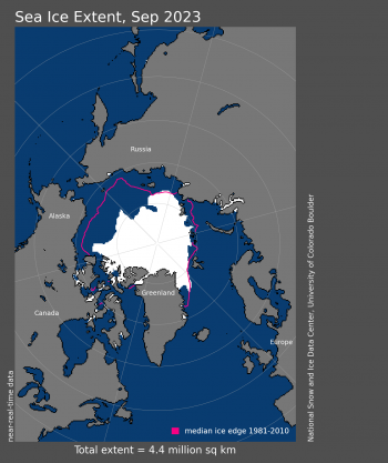
Figure 1a. Arctic sea ice extent for September 2023 was 4.37 million square kilometers (1.69 million square miles). The magenta line shows the 1981 to 2010 average extent for that month. Sea Ice Index data. About the data

Credit: National Snow and Ice Data Center
High-resolution image
Arctic sea ice extent for 2023 and other years

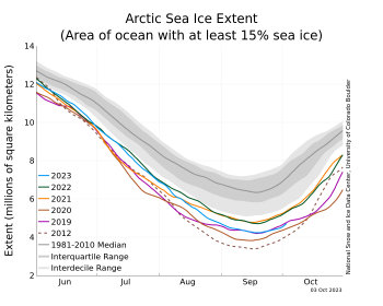
Figure 1b. The graph above shows Arctic sea ice extent as of October 3, 2023, along with daily ice extent data for four previous years and the record low year. 2023 is shown in blue, 2022 in green, 2021 in orange, 2020 in brown, 2019 in magenta, and 2012 in dashed brown. The 1981 to 2010 median is in dark gray. The gray areas around the median line show the interquartile and interdecile ranges of the data. Sea Ice Index data.

Credit: National Snow and Ice Data Center
High-resolution image
sea ice concentration in Arctic on October 2, 2023

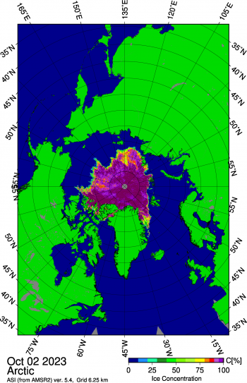
Figure 1c. This image from the Japan Aerospace Exploration Agency (JAXA) Advanced Microwave Scanning Radiometer 2 (AMSR2) shows sea ice concentration in the Arctic Ocean on October 2, 2023, highlighting the openings of sea ice north of Alaska within the Beaufort and Chukchi Seas.

Credit: Japan Aerospace Exploration Agency, courtesy University of Bremen
High-resolution image

Average Arctic sea ice extent for September 2023 was 4.37 million square kilometers (1.69 million square miles), placing it fifth lowest in the 45-year satellite record (Figure 1a). Following the annual minimum of 4.23 million square miles (1.63 million square kilometers), the growth in Arctic sea ice extent has been slower than average (Figure 1b). The image plot for October 2 from the Advanced Microwave Scanning Radiometer 2 (AMSR2) instrument provided by the University of Bremen shows that with the cessation of melt, the ice edge has become more sharply defined (Figure 1c). The lack of ice in the longitudes spanning the Laptev Sea eastward to the Beaufort Sea is striking; before ice forms in these areas the upper ocean will have to lose its remaining heat through radiation and convective transfer to the atmosphere and space. The Northern Sea Route remains essentially free of ice. While both the Northern (deepwater) and Southern (Amundsen’s) routes of the Northwest Passage appear largely ice free, some ice still remains in the northern route, notably at the eastern entrance of M’Clure Strait. This is discussed further below.

Conditions in context
Air temp anomaly September 2023 for Arctic

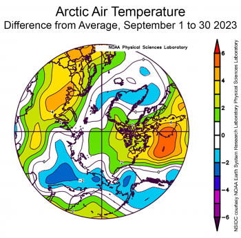
Figure 2a. This plot shows the departure from average air temperature in the Arctic at the 925 hPa level, in degrees Celsius, for September 2023. Yellows and reds indicate above average temperatures; blues and purples indicate below average temperatures.

Credit: NSIDC courtesy NOAA Earth System Research Laboratory Physical Sciences Laboratory
High-resolution image
Average air pressure for September in Arctic

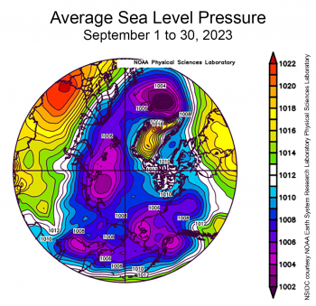
Figure 2b. This plot shows average sea level pressure in the Arctic in millibars for September 2023. Yellows and reds indicate high air pressure; blues and purples indicate low pressure.

Credit: NSIDC courtesy NOAA Earth System Research Laboratory Physical Sciences Laboratory
High-resolution image

Air temperatures at the 925 hPa level (approximately 2,500 feet above the surface) for September were modestly above average, with temperatures 1 to 3 degrees Celsius (2 to 5 degrees Fahrenheit) over most of the Arctic Ocean (Figure 2a). Warm conditions prevailed in the ice-free Norwegian, Barents, and Kara Seas. Over land, Canada and northwestern Eurasia experienced warm conditions, as much at 5 degrees Celsius (9 degrees Fahrenheit) above average.

The atmospheric circulation for September was characterized by fairly low pressure over most of the Arctic Ocean, notably north of the Barents and Laptev Seas and east of Greenland (Figure 2b). Over land, high pressure prevailed over Eurasia and eastern Canada.

September 2023 compared to other years
decline trend line of sea ice in Arctic

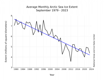
Figure 3. Monthly September ice extent for 1979 to 2023 shows a decline of 12.2 percent per decade.

Credit: National Snow and Ice Data Center
High-resolution image

The downward linear trend in Arctic sea ice extent for September over the 45-year satellite record is 78,500 square kilometers (20,300 square miles) per year, or 12.2 percent per decade relative to the 1981 to 2010 average (Figure 3). Based on the linear trend, since 1979, September has lost 3.45 million square kilometers (1.33 million square miles) of ice. This is roughly equivalent to twice the size of Alaska or Iran.

The Northern Hemisphere’s summer 2023 in review
Air temperature anomaly April to August in Arctic

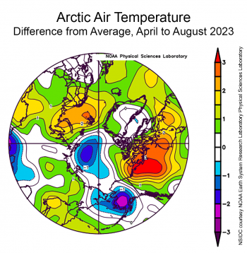
Figure 4a. This plot shows the departure from average air temperature in the Arctic at the 925 hPa level, in degrees Celsius, from April to August 2023. Yellows and reds indicate above average temperatures; blues and purples indicate below average temperatures.

Credit: NSIDC courtesy NOAA Earth System Research Laboratory Physical Sciences Laboratory
High-resolution image
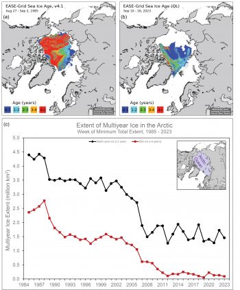
Map and chart of sea ice age in Arctic from 1979 to 2023

Figure 4b. The top maps show Arctic sea ice age at the end of summer, a week before the seasonal minimum, for 1985 on the left and 2023 on the right. The bottom time series shows extent of multiyear ice in black and ice >4 years old in red at the seasonal minimum for 1985 to 2023. The oldest (4+ year old) ice is in red.

Credit: Data and images from Tschudi et al., 2019a and 2019b
High-resolution image

With the passing of the seasonal maximum in Arctic sea ice extent on March 6, the melt season started slowly, but daily extents remained among the third to sixth lowest in the satellite record. The pattern of slow ice loss persisted through April—average extent for April ranked tied with 2002 as tenth lowest in the satellite record. The rate of ice loss picked up towards the end of May, dropping extent below the interdecile range after spending most of the month just above the lower part of the inter-decile range. Nevertheless, extent for the month as a whole ranked only thirteenth lowest in the satellite record. June sea ice loss proceeded at only an average rate and by month’s end, it was clear that a record low September ice extent was highly unlikely. While the rate of Ice loss picked up in August, the sea ice minimum reached on September 19 ended up as sixth lowest in the satellite record. The April through August average air temperate map at the 925 hPa level tells the basic story of 2023—temperatures were below average over much of the Arctic Ocean, limiting melt (Figure 4a). The year nevertheless ended up as notable for the combination of ice-fee conditions in the southern (Amundsen’s) Northwest Passage route and very mild ice conditions in the northern (deepwater) route; this is consistent with the above average temperatures at the 925 hPa level over the Canadian Arctic Archipelago.

Multiyear ice extent at the end of summer was quite low, as has been the case for the last several years (Figure 4b). A band of multiyear ice persists on the Atlantic side, extending from the Laptev Sea across the Arctic north of the Kara and Barents Seas. Much of this ice will likely drift out of the Arctic Ocean with the Transpolar Drift Stream over the next several months to a year. Very little of the oldest (4+ years old) ice remains in the Arctic, with small patches north of Greenland and an area north of the Beaufort Sea. The total extent of the oldest sea ice is 93,000 square kilometers (36,000 square miles), the second lowest in the satellite record since 1985, only higher than 55,000 square kilometers (21,000 square miles) in 2019. This is in stark contrast to the 1980s when old ice covered over 2.5 million square kilometers (965,000 square miles) of the Arctic Ocean.

Note that operational ice services track sea ice daily primarily for the safety of on-ice operations and ships at sea. These services use data sources that go beyond the single source used here. For example, analysts at the US National Ice Center (USNIC) depend on radar and visible-band data when mapping Arctic ice. USNIC tracks Arctic-wide sea ice extent using charts they produce. NSIDC archives these charts. Currently, the USNIC analysis indicates a minimum of 5.05 million square kilometers (1.95 million square miles) on September 27. The USNIC extent values differ from the Sea Ice Index values used by ASINA because of the different imagery and analysis techniques employed.

The Southern Hemisphere’s winter 2023 in review
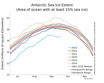
Antarctic sea ice extent for 2023 and other years

Figure 5a. The graph above shows Antarctic sea ice extent as of October 3, 2023, along with daily ice extent data for four previous years and 2014, the record maximum year. 2023 is shown in blue, 2022 in green, 2021 in orange, 2020 in brown, 2019 in magenta, and 2014 in dashed brown. The 1981 to 2010 median is in dark gray. The gray areas around the median line show the interquartile and interdecile ranges of the data. Sea Ice Index data.

Credit: National Snow and Ice Data Center
High-resolution image
animation showing sea ice extent shifting in Antarctic from 1979 to 2023

Figure 5b. Click on image to begin the animation. From 2013 through 2023, Antarctic sea ice exhibited its highest and lowest extents in the satellite record dating back to 1979. From 2013 through 2015, extents were mostly above the 1981 to 2010 average, including the record-high 2014 winter maximum. Beginning in 2016, extents were mostly below the 1981 to 2010 average. Antarctic sea ice extent fell to the lowest minimum on record in March 2023 and the lowest maximum in September 2023.

Credit: Animation by Michon Scott, based on NSIDC’s Charctic Interactive Sea Ice Graph
High-resolution image
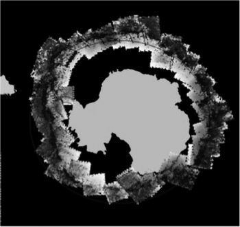
Image of Nimbus data quality for 1966

Figure 5c. This image show the sea ice edge for the last week of August 1966 using the minimum Advanced Vidicon Camera System on the NASA Nimbus satellite. Superimposed is the sea ice edge, depicted as a black line, from the manual analysis.

Credit: Gallagher et al. 2014
High-resolution image
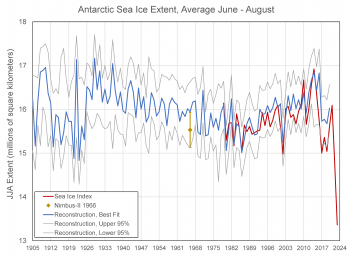
Average sea ice extent based on reconstruction and satellite data from 1905 to 2023

Figure 5d. This graph shows the average Antarctic extent for June through August for multiple decades. The blue line depicts the “best fit” from 1905 to 2020; the grey line depicts the upper and lower 95 percent range for the same time period; and the red line depicts the modern satellite data from the Sea Ice Index from 1979 to 2023. The Nimbus-II 1966 value is marked as a gold diamond within the uncertainty range, which is drawn as vertical gold line.

Credit: W. Meier, NSIDC
High-resolution image

The story for the southern hemisphere was very different. After a record low minimum extent in February 2023, the seasonal increase in ice extent was near average through March, but then began to slow in April (Figure 5a). By May, it became clear that Antarctic sea ice extent, while of course growing in response to seasonal cooling, was lagging far below previous daily lows in the satellite record. Extent was particularly low in the Bellingshausen Sea, Weddell Sea, and western Ross Sea regions. By the middle of July, the heart of austral winter, extent stood at more than 2.60 million square kilometers (1.00 million square miles) below the 1981 to 2010 average, an area nearly as large as Argentina or the combined areas of Texas, California, New Mexico, Arizona, Nevada, Utah, and Colorado. August saw particularly low extent in the Ross Sea and eastern Weddell Sea sectors, but with some recovery in the Bellingshausen Sea. On September 10, 2023, Antarctic extent reached an annual maximum of 16.96 million square kilometers (6.55 million square miles). This year’s maximum was 1.03 million square kilometers (398,000 square miles) below the previous record low set in 1986. There is growing evidence that the Antarctic sea ice system has entered a new regime, featuring a much stronger influence of warm ocean waters limiting ice growth (Figure 5b).

Average Antarctic sea ice extent for September was 16.80 million square kilometers (6.49 million square miles), also far below the previous record for the month. Average September sea ice extent was 1.69 million square kilometers (653,000 square miles) below the 1981 to 2010 average extent of 18.49 million square kilometers (7.14 million square miles). More remarkably, it was 880,000 million square kilometers (340,000 square miles) below 1986, the previous lowest September.

The extents this year have been far outside anything observed in the 45-year modern satellite record that began in 1979. However, some earlier satellite data, including that from the Nimbus satellites in the mid-1960s, point to extents that may rival 2023. Estimates derived from Nimbus-II data suggest that extent for 1966 may have been only slightly higher than 2023 (Gallaher et al., 2014). However, Nimbus-II carried only a visible sensor, which could not collect data during cloudy conditions, resulting in sparse coverage of the Antarctic sea ice region (Figure 5c).

Data was not collected for September when the maximum generally occurs, but only for May through August. In addition, the data quality was limited, making discrimination between ice and ocean difficult. It seems clear that while the 1966 May, June, and July estimates are on par with the 1979 to 2022 values, August 1966 was an outlier with lower extent than July 1966. This is not reasonable given the seasonality of the ice cover. The recovery of such old satellite data is valuable for providing long-term context; however, as just discussed data quality issues preclude making quantitative comparisons with the modern satellite record.

As discussed in the August 2 post, another source of pre-1979 data was recently published at NSIDC (Fogt et al., 2023). It is based on the reconstruction of sea ice extent from climate indices, atmospheric reanalyses, and other information (Fogt et al., 2022). A reconstruction approach uses relationships between observed sea ice extent from satellites and the collection of climate indices to derive a relationship between the two. This relationship is then extrapolated to the pre-satellite period. The reconstruction data set encompasses 1905 to 2020 as seasonal 3-month averages. Comparing the June to August average from that product with the satellite data indicates that this year is well outside average ranges of the 115-year reconstruction (Figure 5d). Like the Nimbus-II data, such reconstructions also have high uncertainty and depend on the assumption that the relationships between satellite data and climate indices are valid over the pre-satellite period.

Sea ice conditions in the Northwest Passage routes during the 2023
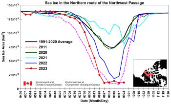
Annual extent of sea ice in Northern route of Northwest Passage for several years and 2023

Figure 6a. This time series shows total sea ice area for 2023, 2022, 2021, 2029, 2011, and the 1991 to 2020 average within the northern route of the Northwest Passage. Data are from the Canadian Ice Service.

Credit: S. Howell, Environment and Climate Change Canada
High-resolution image
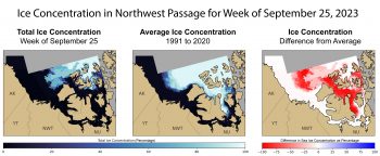
Sea ice concentration in Northwest Passage for week of September 25, 2023

Figure 6b. These maps show sea ice concentration in the Northwest Passage for the week of September 25, 2023. The left map shows spatial distribution of total sea ice concentration; the middle map shows the 1991 to 2020 average sea ice concentration for the same week; and the map on the right shows the difference in sea ice concentrations between the 1991 to 2020 average and the week of September 25, 2023. Red shows a stark decline from the average. Data are from the Canadian Ice Service.

Credit: S. Howell, Environment and Climate Change Canada
High-resolution image
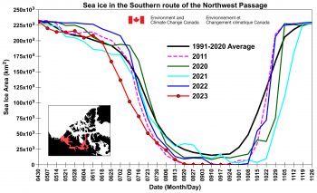
Chart showing extent in southern sea route of Northwest Passage for several years and 2023

Figure 6c. The time series shows total sea ice area for 2023, 2022, 2021, 2029, 2011, and the 1991 and 2020 average within the southern route of the Northwest Passage. Data are from the Canadian Ice Service.

Credit: S. Howell, Environment and Climate Change Canada
High-resolution image

Our colleague Steve Howell at Environment and Climate Change Canada (ECCC) has provided an up-to-date summary of sea ice conditions in the Northwest Passage based on ice charts created by the Canadian Ice Service. While ice conditions at the end of the 2023 melt season were certainly remarkable, the northern route of Northwest Passage route did not break record low conditions of 2011, but still ranks second lowest since 1968 and is well below the 1991 to 2020 average (Figure 6a). Preliminary analysis indicates that the atmospheric circulation over the Canadian Arctic Archipelago during August and September of 2023 was not favorable to Arctic Ocean ice advection, which typically prevents the northern route from clearing. Interestingly, sea ice extent on September 25 is lower than in 2011 during the same time period (Figure 6b). Although the northern route was virtually sea ice free, complete transit without icebreaker escort would be difficult because of sea ice blocking the opening at M’Clure Strait. By contrast, the southern route is sea ice free from end to end (Figure 6c).

Further reading

Fogt, R. L., A. M. Sleinkofer, M. N. Raphael, H. S. and Handcock. 2022. A regime shift in seasonal total Antarctic sea ice extent in the twentieth centuryNature Climate Change 12, 54– 62, doi:10.1038/s41558-021-01254-9.

Fogt, R., M. N. Raphael, and M. S. Handcock. 2023. Seasonal Antarctic Sea Ice Extent Reconstructions, 1905-2020, Version 1 [Data Set]. Boulder, Colorado USA. National Snow and Ice Data Center, doi:10.7265/55×7-we68. Date Accessed 09-28-2023.

Gallaher, D., G. G. Campbell, W. N. Meier. 2014. Anomalous variability in Antarctic sea ice extents during the 1960s with the use of Nimbus data. IEEE Journal of Selected Topics in Applied Earth Observations and Remote Sensing, 3(7), 881-887, doi:10.1109/JSTARS.2013.2264391.

Tschudi, M., W. N. Meier, J. S. Stewart, C. Fowler, and J. Maslanik. 2019a. EASE-Grid Sea Ice Age, Version 4 [Data Set]. Boulder, Colorado USA. NASA National Snow and Ice Data Center Distributed Active Archive Center, doi:10.5067/UTAV7490FEPB. Date Accessed 10-02-2023.

Tschudi, M., W. N. Meier, and J. S. Stewart. 2019b. Quicklook Arctic Weekly EASE-Grid Sea Ice Age, Version 1 [Data Set]. Boulder, Colorado USA. NASA National Snow and Ice Data Center Distributed Active Archive Center, doi:10.5067/2XXGZY3DUGNQ. Date Accessed 10-02-2023.
Antarctic sets a record low maximum by wide margin

On September 10, Antarctic sea ice likely reached its annual maximum extent of 16.96 million square kilometers (6.55 million square miles). This is the lowest sea ice maximum in the 1979 to 2023 sea ice record by a wide margin.

Please note that this is a preliminary announcement. Changing winds or late-season growth could still increase the Antarctic ice extent. NSIDC scientists will release a full analysis of the Antarctic and Arctic September conditions in early October.

Overview of conditions

Antarctic sea ice extent on September 10, 2023

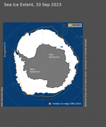
Figure 1. Antarctic sea ice extent for September 10 2023, was 16.96 million square kilometers (6.55 million square miles). The orange line shows the 1981 to 2010 average extent for that day. Sea Ice Index data. About the data

Credit: National Snow and Ice Data Center
High-resolution image

On September 10, 2023, sea ice in the Antarctic reached an annual maximum extent of 16.96 million square kilometers (6.55 million square miles), setting a record low maximum in the satellite record that began in 1979 (Figure 1). This year’s maximum is 1.03 million square kilometers (398,000 square miles) below the previous record low set in 1986. It is also 1.75 million square kilometers below (676,000 square miles) below the 1981 to 2010 average Antarctic maximum extent. Sea ice extent is markedly below average north of Queen Maud Land and west of the Antarctic Peninsula. Other low areas include the Indian Ocean and Ross Sea. Extent is above average stretching out of the Amundsen Sea.

The Antarctic maximum extent is one of the earliest on record, having reached it 13 days earlier than the 1981 to 2010 median date of September 23. The interquartile range for the date of the Antarctic maximum is September 18 to September 30.

Conditions in context

Antarctic sea ice extent compared to other years

Figure 2. The graph above shows Antarctic sea ice extent as of September 10, 2023, along with daily ice extent data for four previous years and the record maximum year. 2023 is shown in blue, 2022 in green, 2021 in orange, 2020 in brown, 2019 in magenta, and 2014 in dashed brown. The 1981 to 2010 median is in dark gray. The gray areas around the median line show the interquartile and interdecile ranges of the data. Sea Ice Index data.

Credit: National Snow and Ice Data Center
High-resolution image

This year marks a significant record low maximum in Antarctic sea ice extent (Figure 2). Since early April 2023, sea ice maintained record low ice growth. From early to mid-August, growth slowed considerably, maintaining a difference of nearly 1.5 million square kilometers (579,000 square miles) between 2023 and 1986, the second lowest year on satellite record. After that period, ice growth quickened and narrowed the gap to about 1 million square kilometers (386,000 square miles). This is the first time that sea ice extent has not surpassed 17 million square kilometers (6.56 million square miles), falling more than one million square kilometers below the previous record low maximum extent set in 1986. 

While weather conditions like winds and temperature control much of the day-to-day variations in ice extent, the long-term downward trend is a topic of much debate. The overall, trend in the maximum extent from 1979 to 2023 is 0.1 percent per decade relative to the 1981 to 2010 average, which is not a significant trend.
However, since August 2016, the Antarctic sea ice extent trend took a sharp downturn across nearly all months (Figure 4c in previous post). Most research has suggested that changes in the near-surface ocean heat content is responsible for the sluggish growth in the past several months. A downturn in 2016 was attributed to a series of storms in the Weddell and Ross Sea regions that pushed the ice edge southward (Turner et al., 2017). Similar extremes in long-lived weather patterns like the record Amundsen Sea Low strength are implicated in the generally low ice extents of 2022 (Turner et al., 2022). However, this more recent excursion, beginning in May of 2023, and the general persistence of low sea ice extent near Antarctica since 2016, is now thought to be linked to warming in the uppermost ocean layer caused by lateral and upward mixing of warmer water (Zhang et al., 2022; Haumann et al., in press)
 
There is some concern that this may be the beginning of a long-term trend of decline for Antarctic sea ice, since oceans are warming globally, and warm water mixing in the Southern Ocean polar layer could continue. The Southern Ocean and its sea ice is an important component of Earth’s energy balance, reflecting sunlight back into space, and supporting a rich ice-edge ecosystem. Moreover, if dramatically lower sea ice extent continues to the 2024 summer minimum and beyond, much more of the Antarctic coastline will be exposed to ocean waves and marine climate. This may lead to two opposing impacts: erosion of more perennial coastal ice and ice shelves, destabilizing the ice sheet; or increased accumulation near the coast, offsetting in part the threat of rising sea level.

Ten lowest maximum Antarctic sea ice extents (satellite record, 1979 to present)

Table 1. Ten lowest maximum Antarctic sea ice extents (satellite record, 1979 to present)
RANK YEAR Maximum ICE EXTENT DATE
IN MILLIONS OF SQUARE KILOMETERS IN MILLIONS OF SQUARE MILES
1 2023 16.96 6.55 Sept. 10
2 1986 17.99 6.95 Oct. 10
3 2002 18.05 6.97 Oct. 12
4 2017 18.10 6.99 Oct. 10
7 1989
2022
2018
2008
18.22
18.25
18.25
18.26
7.03
7.05
7.05
7.05
Sept. 25
Sept. 16
Oct. 03
Sept. 06

Values within 40,000 square kilometers (15,000 square miles) are considered tied.

References

Purich, A. and E. W. Doddridge. 2023. Record low Antarctic sea ice coverage indicates a new sea ice state. Communications Earth and Environment 4, 314, doi:10.1038/s43247-023-00961-9.
Turner, J., T. Phillips, G. J. Marshall, J. S. Hosking, J. O. Pope, T. J. Bracegirdle, and P. Deb. 2017. Unprecedented springtime retreat of Antarctic sea ice in 2016Geophysical Research Letters, 44(13), 6868-6875, doi:10.1002/2017GL073656.

Turner, J., C. Holmes, T. Caton Harrison, T. Phillips, B. Jena, T. Reeves‐Francois, R. Fogt, E. R. Thomas, C. C. and Bajish. 2022. Record low Antarctic sea ice cover in February 2022. Geophysical Research Letters, 49(12), e2022GL098904, doi:10.1029/2022GL098904.

Zhang, L., T. L. Delworth, X. Yang, F. Zeng, F. Lu, Y. Morioka, and M. Bushuk. 2022. The relative role of the subsurface Southern Ocean in driving negative Antarctic Sea ice extent anomalies in 2016–2021, 3, 302, Communications Earth and Environment doi:10.1038/s43247-022-00624-1.

For more information

NASA visualization of 2023 Arctic sea ice minimum extent

Arctic sea ice minimum at sixth lowest extent on record

On September 19, Arctic sea ice likely reached its annual minimum extent of 4.23 million square kilometers (1.63 million square miles). The 2023 minimum is sixth lowest in the nearly 45-year satellite record. The last 17 years, from 2007 to 2023, are the lowest 17 sea ice extents in the satellite record.

In the Antarctic, sea ice extent set unprecedented record lows through most of the growth season. Highly variable conditions are typical of Antarctic sea ice extent near the seasonal maximum, and ice may still continue to grow but will unlikely avoid setting a record low. The previous five lowest maximums on record include 1986, 2002, 2017, 1989, and 2022. The maximum for Antarctic sea ice typically occurs in late September or early October, but has been as early as August 30.

Please note that this is a preliminary announcement. Changing winds or late-season melt could still reduce the Arctic ice extent, as happened in 2005 and 2010. NSIDC scientists will release a full analysis of the Arctic melt season, and discuss the Antarctic winter sea ice growth, in early October.

Overview of conditions

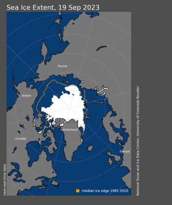
Figure 1. Arctic sea ice extent for XXXX XX, 20XX, was X.XX million square kilometers (X.XX million square miles). The orange line shows the 1981 to 2010 average extent for that day. Sea Ice Index data. About the data||Credit: National Snow and Ice Data Center|High-resolution image

Figure 1. Arctic sea ice extent for September 19 2023, was 4.23 million square kilometers (1.63 million square miles). The orange line shows the 1981 to 2010 average extent for that day. Sea Ice Index data. About the data

Credit: National Snow and Ice Data Center
High-resolution image

On September 19, sea ice reached its annual minimum extent of 4.23 million square kilometers (1.63 million square miles) (Figure 1). As the sun continues to lower on the horizon, air temperatures will drop further, expanding ice extent through autumn and winter. However, with significant patches of low ice concentration a late season storm may compress the sea ice and push the ice extent lower.

The minimum extent was reached five days later than the 1981 to 2010 median minimum date of September 14. The interquartile range of minimum dates is September 11 to September 19.

Conditions in context

Figure 2. The graph above shows Arctic sea ice extent as of XXXXX XX, 20XX, along with daily ice extent data for four previous years and the record low year. 2023 is shown in blue, 2022 in green, 2021 in orange, 2020 in brown, 2019 in magenta, and 2012 in dashed brown. The 1981 to 2010 median is in dark gray. The gray areas around the median line show the interquartile and interdecile ranges of the data. Sea Ice Index data.||Credit: National Snow and Ice Data Center|High-resolution image

Figure 2. The graph above shows Arctic sea ice extent as of September 19, 2023, along with daily ice extent data for four previous years and the record low year. 2023 is shown in blue, 2022 in green, 2021 in orange, 2020 in brown, 2019 in magenta, and 2012 in dashed brown. The 1981 to 2010 median is in dark gray. The gray areas around the median line show the interquartile and interdecile ranges of the data. Sea Ice Index data.

Credit: National Snow and Ice Data Center
High-resolution image

This year’s minimum set on September 19 was 840,000 square kilometers (324,000 square miles) above the satellite-era record minimum extent of 3.39 million square kilometers (1.31 million square miles), which occurred on September 17, 2012 (Figure 2). It is also 1.99 million square kilometers (770,000 square miles) below the 1981 to 2010 average minimum extent, which is equivalent to nearly three times the size of Texas.

In the 45-year-satellite record, 17 of the lowest minimums have all occurred in the last 17 years.

The overall, downward trend in the minimum extent from 1979 to 2023 is 12.5 percent per decade relative to the 1981 to 2010 average. The loss of sea ice is about 77,800 square kilometers (30,000 square miles) per year, equivalent to losing the state of Nebraska or the Czech Republic annually.

Seventeen lowest minimum Arctic sea ice extents (satellite record, 1979 to present)

Table 1. Seventeen lowest minimum Arctic sea ice extents (satellite record, 1979 to present)
RANK YEAR MINIMUM ICE EXTENT DATE
IN MILLIONS OF SQUARE KILOMETERS IN MILLIONS OF SQUARE MILES
1 2012 3.39 1.31 Sept. 17
2 2020 3.82 1.47 Sept. 16
3 2007
2016
2019
4.16
4.17
4.19
1.61
1.61
1.62
Sept. 18
Sept. 10
Sept. 18
6 2023 4.23 1.63 Sept. 19
7 2011 4.34 1.68 Sept. 11
8 2015 4.43 1.71 Sept. 9
9 2008
2010
4.59
4.62
1.77
1.78
Sept. 19
Sept. 21
11 2018
2017
2022
4.66
4.67
4.70
1.80
1.80
1.81
Sept. 23
Sept. 13
Sept. 19
14 2021 4.77 1.84 Sept. 16
15 2014
2013
5.03
5.05
1.94
1.95
Sept. 17
Sept. 13
17 2009 5.12 1.98 Sept. 13

Values within 40,000 square kilometers (15,000 square miles) are considered tied. The 2022 value has changed from 4.67 to 4.70 million square kilometers (1.81 million square miles) and the date of the minimum moved from September 18 to September 19 when final analysis data updated near-real-time data. 

For more information

NASA visualization of 2023 Arctic sea ice minimum extent

Rounding the curve

Both Arctic and Antarctic sea ice appear to be heading toward their respective seasonal limits, reaching the lowest extent at the end of summer in the north, and the highest extent as winter ends in the south. In the Antarctic, high variability typically characterizes the period around the maximum, but at present the sea ice extent is more than 1 million square kilometers (386,000 square miles) below the previous record low maximum set in 1986.

Overview of conditions

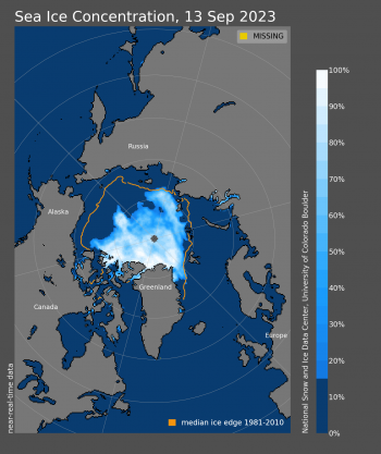
Figure 1a. This figure shows Arctic sea ice concentration for September 13. The orange line shows the 1981 to 2010 average extent for that day. Sea Ice Index data. About the data||Credit: National Snow and Ice Data Center|High-resolution image

Figure 1a. This figure shows Arctic sea ice concentration for September 13. The orange line shows the 1981 to 2010 average extent for that day. Sea Ice Index data. About the data

Credit: National Snow and Ice Data Center
High-resolution image

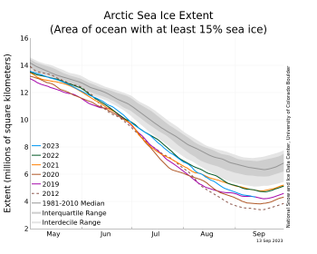
Figure 1b. The graph above shows Arctic sea ice extent as of September 13, 2023, along with daily ice extent data for four previous years and the record low year. 2023 is shown in blue, 2022 in green, 2021 in orange, 2020 in brown, 2019 in magenta, and 2012 in dashed brown. The 1981 to 2010 median is in dark gray. The gray areas around the median line show the interquartile and interdecile ranges of the data. Sea Ice Index data.||Credit: National Snow and Ice Data Center|High-resolution image

Figure 1b. The graph above shows Arctic sea ice extent as of September 13, 2023, along with daily ice extent data for four previous years and the record low year. 2023 is shown in blue, 2022 in green, 2021 in orange, 2020 in brown, 2019 in magenta, and 2012 in dashed brown. The 1981 to 2010 median is in dark gray. The gray areas around the median line show the interquartile and interdecile ranges of the data. Sea Ice Index data.

Credit: National Snow and Ice Data Center
High-resolution image

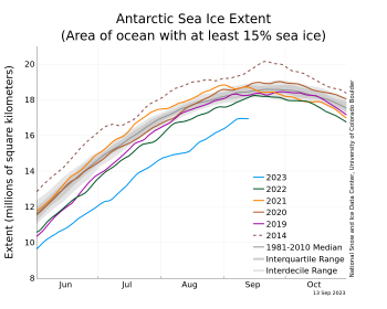
Figure 1c. The graph above shows Antarctic sea ice extent as of September 13, 2023, along with daily ice extent data for four previous years and the record high year. 2023 is shown in blue, 2022 in green, 2021 in orange, 2020 in brown, 2019 in magenta, and 2014 in dashed brown. The 1981 to 2010 median is in dark gray. The gray areas around the median line show the interquartile and interdecile ranges of the data. Sea Ice Index data.||Credit: National Snow and Ice Data Center|High-resolution image

Figure 1c. The graph above shows Antarctic sea ice extent as of September 13, 2023, along with daily ice extent data for four previous years and the record high year. 2023 is shown in blue, 2022 in green, 2021 in orange, 2020 in brown, 2019 in magenta, and 2014 in dashed brown. The 1981 to 2010 median is in dark gray. The gray areas around the median line show the interquartile and interdecile ranges of the data. Sea Ice Index data.

Credit: National Snow and Ice Data Center
High-resolution image

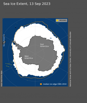
Figure 1d. Antarctic sea ice extent for September 13, 2023 was 16.94 million square kilometers (6.54 million square miles). The orange line shows the 1981 to 2010 average extent for that day. Sea Ice Index data. About the data||Credit: National Snow and Ice Data Center|High-resolution image

Figure 1d. Antarctic sea ice extent for September 13, 2023 was 16.94 million square kilometers (6.54 million square miles). The orange line shows the 1981 to 2010 average extent for that day. Sea Ice Index data. About the data

Credit: National Snow and Ice Data Center
High-resolution image

Retreat of Arctic sea ice cover has been primarily in the central Arctic region north of the Laptev and East Siberian Seas in an area of low sea ice concentration (Figure 1a). A few large areas of open water are present between several areas of higher-concentration sea ice. On the Pacific side, the Beaufort and Chukchi Seas have very little sea ice remaining; on the Atlantic side, both the Svalbard archipelago and Franz Josef Land are largely ice free (Figure 1a). Both passages of the Northwest Passage are largely clear of ice at the resolution of passive microwave satellite data, but likely have patchy ice remaining. Ice blocks the western end of the Parry Channel near M’Clure Strait, but the ice edge has pulled away from the coast in recent days and it appears that there is a narrow ice-free region along the northwest coast of Banks Island.

Antarctic sea ice grew at a much faster-than-average pace through the first eight days of September, increasing at 65,000 square kilometers (25,000 square miles) per day relative to the 1981 to 2010 average rate of 25,000 square kilometers (9,700 square miles) per day (Figure 1c). Much of this expansion occurred in the northeastern Ross Sea and along the Weddell Sea ice front (Figure 1d). However, growth slowed after September 8. If no further net growth occurs, the sea ice maximum will be below 17 million square kilometers (6.56 million square miles) for the first time in the satellite record, and about one million square kilometers (386,000 square miles) below the previous record low maximum of 1986. The five low maximum sea ice extents for Antarctica include 1986, 2002, 2017, 1989, and 2022. High variability is typical of the sea ice maximum period, and further growth is likely from storms or high winds along the vast circumpolar sea ice edge.

Conditions in context

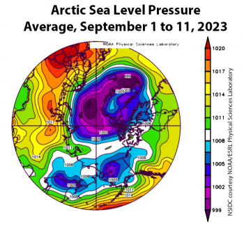
Figure 2a. This plot shows average sea level pressure in the Arctic in millibars for September 1 to 11, 2023. Yellows and reds indicate high air pressure; blues and purples indicate low pressure. ||Credit: NSIDC courtesy NOAA Earth System Research Laboratory Physical Sciences Laboratory| High-resolution image
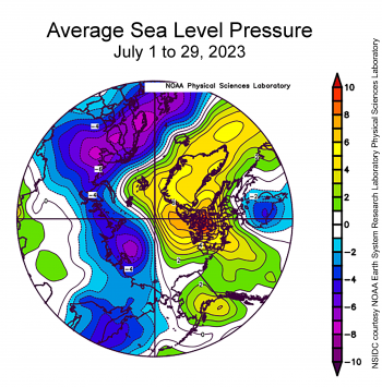
Figure 2a. This plot shows average sea level pressure in the Arctic in millibars for September 1 to 11, 2023. Yellows and reds indicate above average air pressure; blues and purples indicate below average pressure.
Credit: NSIDC courtesy NOAA Earth System Research Laboratory Physical Sciences Laboratory
High-resolution image

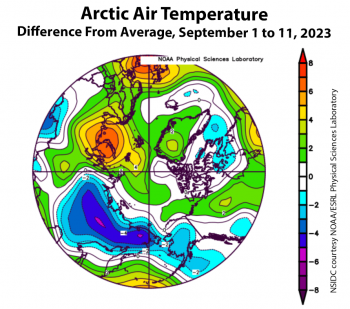
Figure 2b. This plot shows the departure from average air temperature in the Arctic at the 925 hPa level, in degrees Celsius, for September 1 to 11, 2023. Yellows and reds indicate higher than average temperatures; blues and purples indicate lower than average temperatures. ||Credit: NSIDC courtesy NOAA Earth System Research Laboratory Physical Sciences Laboratory| High-resolution image
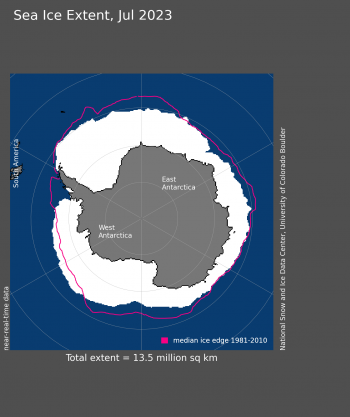
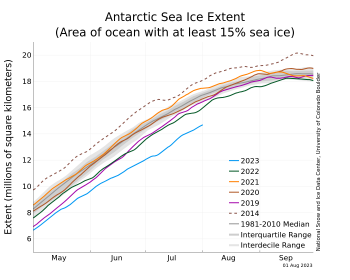
Figure 2b. This plot shows the departure from average air temperature in the Arctic at the 925 hPa level, in degrees Celsius, for September 1 to 11, 2023. Yellows and reds indicate higher than average temperatures; blues and purples indicate lower than average temperatures.

Credit: NSIDC courtesy NOAA Earth System Research Laboratory Physical Sciences Laboratory
High-resolution image

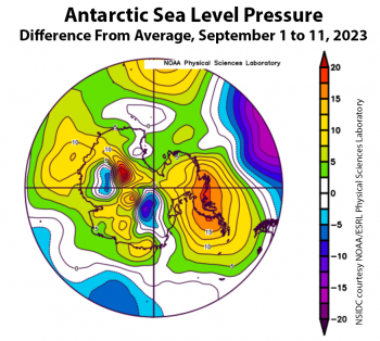
Figure 2c. This plot shows the departure from average sea level pressure in the Antarctic in millibars for September 1 to 11, 2023. Yellows and reds indicate high air pressure; blues and purples indicate low pressure. ||Credit: NSIDC courtesy NOAA Earth System Research Laboratory Physical Sciences Laboratory| High-resolution image

Figure 2c. This plot shows the departure from average sea level pressure in the Antarctic in millibars for September 1 to 11, 2023. Yellows and reds indicate high air pressure; blues and purples indicate low pressure.

Credit: NSIDC courtesy NOAA Earth System Research Laboratory Physical Sciences Laboratory
High-resolution image

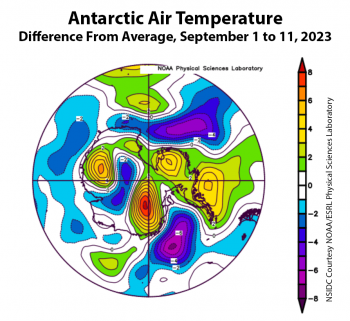
Figure 2d. This plot shows the departure from average air temperature in the Antarctic at the 925 hPa level, in degrees Celsius, for September 1 to 11, 2023. Yellows and reds indicate higher than average temperatures; blues and purples indicate lower than average temperatures. ||Credit: NSIDC courtesy NOAA Earth System Research Laboratory Physical Sciences Laboratory| High-resolution image

Figure 2d. This plot shows the departure from average air temperature in the Antarctic at the 925 hPa level, in degrees Celsius, for September 1 to 11, 2023. Yellows and reds indicate higher than average temperatures; blues and purples indicate lower than average temperatures.

Credit: NSIDC courtesy NOAA Earth System Research Laboratory Physical Sciences Laboratory
High-resolution image

For the first two weeks of September, high air pressure prevailed over northern Siberia, with low pressure over Greenland, which created significant winds along the Eurasian coast (Figure 2a). Air temperatures were generally above average in Western Europe and Scandinavia, and below average in eastern Siberia (Figure 2b). The outlook for a few more days is for continued warm conditions and airflow that may cause further contraction of the low-concentration sea ice.

In Antarctica, a strong high-pressure area over the Peninsula region with counterclockwise airflow helped push sea ice outward along the northwestern Weddell Sea, where the air temperature was quite low (Figure 2c). Low air pressure and below average temperatures in the central and western Ross Sea helped push sea ice outward in the eastern Ross Sea (Figure 2d). Storms will very likely cause the sea ice edge to fluctuate.

Late summer heat wave avoids central Arctic

While the first half of August saw a rapid pace of Arctic sea ice loss, the pace slowed during the latter half of the month as mostly cooler conditions set in. Antarctic sea ice extent increased during the second half of the month.

Overview of conditions

Arctic sea ice extent map for August 2023

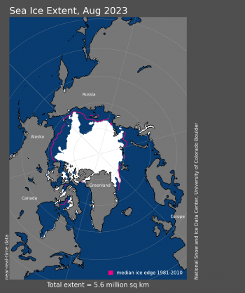
Figure 1a. Arctic sea ice extent for August 2023 was 5.57 million square kilometers (2.15 million square miles). The magenta line shows the 1981 to 2010 average extent for that month. Sea Ice Index data. About the data

Credit: National Snow and Ice Data Center
High-resolution image

Graph of Arctic sea ice extent for 2023 and several other years

Figure 1b. The graph above shows Arctic sea ice extent as of September 4, 2023, along with daily ice extent data for four previous years and the record low year. 2023 is shown in blue, 2022 in green, 2021 in orange, 2020 in brown, 2019 in magenta, and 2012 in dashed brown. The 1981 to 2010 median is in dark gray. The gray areas around the median line show the interquartile and interdecile ranges of the data. Sea Ice Index data.

Credit: National Snow and Ice Data Center
High-resolution image

August Arctic sea ice extent averaged 5.57 million square kilometers (2.15 million square miles), or the eighth lowest in the 45-year satellite record (Figure 1a). Extent was 1.63 million square kilometers (629,000 square miles) below the 1981 to 2010 reference period and 850,000 square kilometers (328,000 square miles) above the previous record low for the month set in 2012. As of the end of August, 2.24 million square kilometers (860,000 square miles) of sea ice was lost in the Arctic.

As is typical during the latter half of August, the pace of ice loss slowed (Figure 1b).  Nevertheless, the daily ice loss rate of 72,100 square kilometers (27,800 square miles) per day was faster than the 1981 to 2010 average of 57,200 square kilometers (22,100 square miles) per day.

At month’s end, the ice edge remained considerably farther north than average in the Beaufort, Chukchi and East Siberian Seas, while in the Kara and Barents Seas the ice edge was near its typical location, albeit farther north in a few scattered regions. In the East Greenland Sea the ice was also well north of its usual position, in large part because of reduced ice export out of Fram Strait. While the ice edge in the Laptev Sea was near average, large areas of low ice concentration and open water were present.

The southern Northwest Passage, known as Amundsen’s route, remains nearly ice free, and the northern deepwater route between M’Clure Strait and Lancaster Sound has less ice than the previous record low for this time of year set in 2011. However, some ice still clogs M’Clure Strait and ice in the Beaufort Sea hinders easy access.

Conditions in context

Arctic air temperature August 15 to 31, 2023

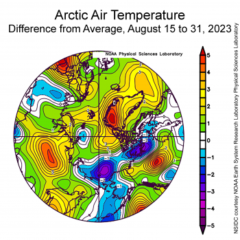
Figure 2a. This plot shows the departure from average air temperature in the Arctic at the 925 hPa level, in degrees Celsius, from August 15 to 31, 2023. Yellows and reds indicate higher than average temperatures; blues and purples indicate lower than average temperatures.

Credit: NSIDC courtesy NOAA Earth System Research Laboratory Physical Sciences Laboratory
High-resolution image

Average sea level pressure for Arctic August 15 to 31, 2023

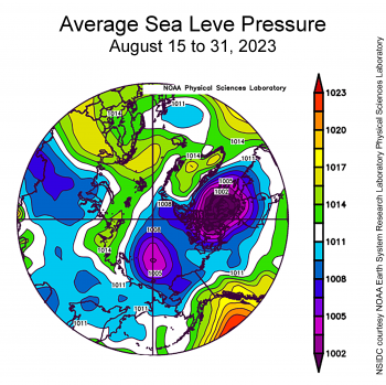
Figure 2b. This plot shows average sea level pressure in the Arctic in millibars from August 15 to 31, 2023. Yellows and reds indicate high air pressure; blues and purples indicate low pressure.

Credit: NSIDC courtesy NOAA Earth System Research Laboratory Physical Sciences Laboratory
High-resolution image

During the second half of August, air temperatures at the 925 millibar level (about 2,500 feet above the surface) averaged 1 to 5 degrees Celsius (2 to 9 degrees Fahrenheit) below average in the Chukchi and East Siberian Seas, whereas above-average air temperatures prevailed in northern Greenland at 1 to 6 degrees Celsius (2 to 11 degrees Fahrenheit) (Figure 2a). Patches of warm conditions persisted in the Kara and Barents Seas of 1 to 3 degrees Celsius (2 to 5 degrees Fahrenheit) above average, though cool conditions were nearby. This contrasts with the pattern observed in the first half of the month when temperatures were below average north of Greenland, above average in the Chukchi and East Siberian Seas, and considerably above average in the Kara and Barents Seas.

Conditions shifted with the development of prominent areas of low sea level pressure over northern Canada and the Central Arctic Ocean; the latter feature is typical for this time of year (Figure 2b). By contrast, high pressure lingered over Greenland, the Norwegian Sea, and extended eastward along the Russian coast into the Laptev Sea. The high pressure over the Norwegian Sea and the implied winds from the south helped to transport warm air northward and also inhibited ice transport out of Fram Strait. Low pressure over the central Arctic Ocean helped to transport cold air southwards, contributing to the cool conditions over the Chukchi Sea.

August 2023 compared to previous years

trend line of decline for August sea ice extent from 1979 to 2023

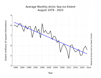
Figure 3. Monthly August ice extent for 1979 to 2023 shows a decline of 9.9 percent per decade.

Credit: National Snow and Ice Data Center
High-resolution image

The downward linear trend in Arctic sea ice extent in August over the 45-year satellite record is 71,400 square kilometers (27,600 square miles) per year, or 9.9 percent per decade relative to the 1981 to 2010 average (Figure 3). Based on the linear trend, since 1979, August has lost 3.14 million square kilometers (1.21 million square miles) of ice. This is roughly equivalent to twice size of state of Alaska or the country of Iran.

Cascading impacts of changing sea ice conditions on marine ecosystems

present and future illustrations of phytoplankton blooms

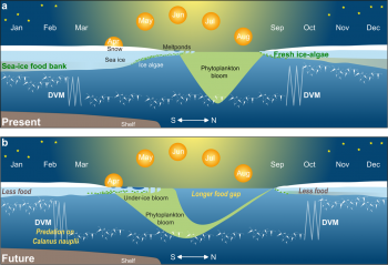
Figure 4. The top illustration shows the current seasonal cycle in the diel vertical migration (DVM), also known as diurnal vertical migration of zooplankton and its links to sunlight. The bottom panel shows a possible future scenario of the impact of earlier spring light penetration and later autumn freeze up on the DVM within the surface layer, up to 50 meters (164 feet) of the Arctic Ocean. This assumes a ‘business-as-usual’ (SSP5-8.5) emission scenario. The intensity of the green-brown shading in the sea ice reflects potential changes in sea ice algae while the green shading of phytoplankton blooms is not scaled to productivity or biomass.

Credit: Based on scenarios shown in Soreide et al. 2010, Leu et al. 2011, Wassmann and Reigstad 2011, and Ardyna and Arrigo 2020
High-resolution image

The largest biomass migration on Earth each day happens within our oceans. Zooplankton, including tiny copepods and krill, migrate during the night towards the ocean surface to feed and then retreat to deeper depths during daylight to avoid predation. In the Arctic, however, the alternation of winter’s polar night and summer’s polar day results in a seasonal migration pattern. During the polar day, zooplankton primarily feed on phytoplankton blooms but during the polar night, they travel to the underside of the ice to feed on ice algae. As sea ice shrinks and thins, more light enters the ocean and shifts the seasonal migration. According to researchers at the Alfred Wegener Institute (AWI) and National Snow and Ice Data Center (NSIDC) scientist Julienne Stroeve, zooplankton prefer to stay at depths where light levels are below a certain intensity. Using mooring data deployed at the end of the year-long Multidisciplinary drifting Observatory for the Study of Arctic Climate (MOSAiC) expedition, they quantify this critical light threshold. Using this threshold in climate model simulations, they conclude that as sea ice continues to thin, the ocean level at which this critical light threshold is reached deepens earlier in the year, resulting in zooplankton remaining at depth for longer before coming to the surface to feed on sea ice algae. Currently, the zooplankton begin their springtime downward migration after nauplius larvae of the copepod C. hyperboreus have migrated to the surface and developed to copepodites. As the ice cover reduces, this springtime migration will start earlier. This will change their feeding habits, perhaps feeding on the C. hyperboreus nauplii before they have fully developed. Changing light levels will also shift the biomass and seasonality of ice algae and phytoplankton, the food sources for zooplankton. Since zooplankton feed the fish that feed the seals and whales, this change can cascade through the marine ecosystem.

Northwest Passage

sea ice extent in southern route of Northwest Passage

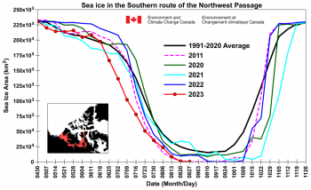
Figure 5a. This time series graph shows total sea ice area for 2023, 2022, 2021, 2020, 2011, and the 1991 to 2020 average within the southern route of the Northwest Passage.

Credit: S. Howell, Canadian Ice Service
High-resolution image

Sea ice are in northern route of Northwest Passage for 2023 and other years

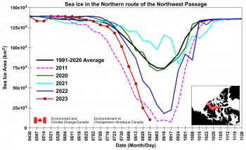
Figure 5b. This time series graph shows total sea ice area for 2023, 2022, 2021, 2020, 2011, and the 1991 to 2020 average within the northern route of the Northwest Passage.

Credit: S. Howell, Canadian Ice Service
High-resolution image

As of August 28, the southern route of the Northwest Passage, known as Amundsen’s route, is almost completely free of sea ice (Figure 5a). The sea ice area in the northern route (deep water) is currently tracking just above 2011 record low conditions (Figure 5b). The route is almost sea ice free with the exception of the vicinity of the western end of M’Clure Strait. Although ice conditions have been very light this year as well as in 2022, it is important to note that ice conditions can be highly variable. While light ice years in the Northwest Passage may occur more frequently as the Arctic continues to warm, the processes of sea ice transport and the aging of seasonal first year ice that lead to heavy ice years in the Northwest Passage, such as in 2021 and 2020, still continue to operate.

Floe-ing with the landscape

satellite images of buoys drifting over time in summer of 2020

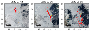
Figure 6. These three satellite images show buoy positions in red and sea ice conditions from the Moderate Resolution Imaging Spectroradiometer (MODIS) on July 12, July 26, and August 6, from left to right. The blue star shows the location of the Multidisciplinary drifting Observatory for the Study of Arctic Climate (MOSAiC) Central Observatory where one of the buoys was deployed.

Credit: Watkins, D. M. et al, 2023
High-resolution image

A recent paper led by colleagues at Brown University highlights the tight coupling between sea ice and ocean dynamics in the Fram Strait region. Fram Strait—the passage between Greenland and the Svalbard archipelago—is the key deepwater connection between the Arctic and Atlantic Oceans. It is also the primary region where sea ice is exported from the Arctic Ocean into the Atlantic. Figure 6 shows an ensemble of drifting buoys that were deployed as part of the international Multidisciplinary drifting Observatory for the Study of Arctic Climate (MOSAiC) expedition in Fall 2019 in the Laptev Sea. The buoys were carried westward by the Transpolar Drift Stream, and then flushed through Fram Strait and into the East Greenland Sea during spring and summer 2020. The authors documented clear changes in sea ice dynamics as the buoys crossed over undersea features, such as the Yermak Plateau north of Svalbard and the East Greenland Continental Shelf. These changes are concentrated at frequencies corresponding to tides and inertial oscillations, which show how the seafloor topography influences sea ice. The importance of ocean currents for the sea ice drift was further shown using a new ice tracking algorithm called Ice Floe Tracker. The team showed an increased role for ocean forcing relative to wind forcing on marginal ice zone sea ice in shallow seas and near the edge of the continental shelf.

Antarctic growth accelerates

Antarctic sea ice extent as of September 4, 2023 with other years for comparison

Figure 7. The graph above shows Antarctic sea ice extent as of September 4, 2023, along with daily ice extent data for four previous years and the record high year. 2023 is shown in blue, 2022 in green, 2021 in orange, 2020 in brown, 2019 in magenta, and 2014 in dashed brown. The 1981 to 2010 median is in dark gray. The gray areas around the median line show the interquartile and interdecile ranges of the data. Sea Ice Index data.

Credit: National Snow and Ice Data Center
High-resolution image

After a brief period of slow growth during the first half of August, ice growth quickened in the Southern Hemisphere. While the total Antarctic sea ice extent is still tracking at record low levels, the ice extent has increased more than average in the Bellingshausen and Amundsen Seas as well as in the Pacific Ocean. Elsewhere the ice edge remains further poleward than average.


References

Flores, H., G. Veyssière, G. Castellani, et al. 2023. Sea-ice decline could keep zooplankton deeper for longerNature Climate Change, doi:10.1038/s41558-023-01779-1

Howell, S. E. L., D. G. Babb, J. C. Landy, and M. Brady. 2022. Multi-year sea ice conditions in the Northwest Passage: 1968-2020. Atmosphere-Ocean, 1, 15, doi:10.1080/07055900.2022.2136061

Howell, S. E. L., D. G. Babb, J. C. Landy, G. W. K. Moore, B. Montpetit, and M. Brady. 2023. A comparison of Arctic Ocean sea ice export between Nares Strait and the Canadian Arctic Archipelago. Journal of Geophysical Research: Oceans, 128, e2023JC019687, doi:10.1029/2023JC019687

Watkins, D. M., A. C. Bliss, J. K. Hutchings, and M. M. Wilhelmus. 2023. Evidence of abrupt transitions between sea ice dynamical regimes in the East Greenland marginal ice zone. Geophysical Research Letters, 50, e2023GL103558, doi:10.1029/2023GL103558

A change is afoot

After declining at a near-average pace for much of the summer, Arctic sea ice loss accelerated during early August. Antarctic sea extent continues to increase but at an unusually slow pace, exacerbating the record low extent levels seen throughout the austral autumn and winter.

Overview of conditions

Arctic sea ice extent as of August 15, 2023, compared to other years

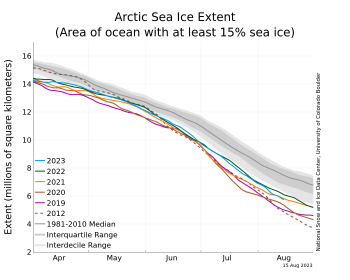
Figure 1a. The graph above shows Arctic sea ice extent as of August 15, 2023, along with daily ice extent data for four previous years and the record low year. 2023 is shown in blue, 2022 in green, 2021 in orange, 2020 in brown, 2019 in magenta, and 2012 in dashed brown. The 1981 to 2010 median is in dark gray. The gray areas around the median line show the interquartile and interdecile ranges of the data. Sea Ice Index data.

Credit: National Snow and Ice Data Center
High-resolution image

map of sea ice extent in Arctic as of August 15, 2023

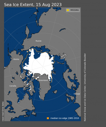
Figure 1b. Arctic sea ice extent for August 15, 2023, was 5.74 million square kilometers (2.22 million square miles). The orange line shows the 1981 to 2010 average extent for that day. Sea Ice Index data. About the data

Credit: National Snow and Ice Data Center
High-resolution image

sea ice concentration as of August 15, 2023

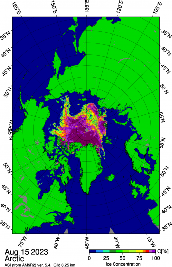
Figure 1c. This map shows a swath of low concentration within the sea ice extent north of the Laptev Sea on August 15, 2023. Sea ice concentration data are from Advanced Microwave Scanning Radiometer 2 (AMSR2) imagery.

Credit: University of Bremen
High-resolution image

The decline in Arctic sea ice extent through the first half of August was faster than average (Figure 1a). Over the period August 1 to 15, 2023, extent decreased at a rate of 81,000 square kilometers (31,000 square miles) per day, compared to the 1981 to 2010 average of 69,000 square kilometers (27,000 square miles) per day. As of August 15, extent stood at 5.74 million square kilometers (2.22 million square miles) (Figure 1b), 1.56 million square kilometers (600,000 square miles) below the 1981 to 2010 average for that date. The mid-August extent is the ninth lowest in the 45-year satellite record.

At mid-month, extent remains near average on the Atlantic side of the Arctic, but elsewhere is well below average other than a tongue of ice extending toward the coast in the East Siberian Sea just west of Wrangel Island. There is also a small area of ice extending near the shore along the western part of the Northern Sea Route near Severnaya Zemlya in the Kara Sea. Both of these regions of ice may melt out within the next couple of weeks.

The Northwest Passage appears to be on the verge of becoming nearly ice free, particularly the southern route, known as Amundsen’s route. The northern route through the relatively wide Parry Channel, is still blocked by ice, but at relatively low concentration.

Elsewhere, a swath of low concentration extended into the ice pack north of the Laptev Sea (Figure 1c). This may represent a response to a low-pressure system that moved into the region on August 14. While not particularly strong (994 millibar), such storms tend to cause divergent flow in the sea ice pack and increase wave action that break up the ice.

Conditions in context

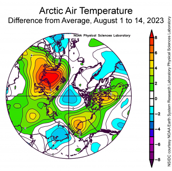
Arctic air temperature as difference from average

Figure 2a. This plot shows the departure from average air temperature in the Arctic at the 925 hPa level, in degrees Celsius, from August 1 to 14, 2023. Yellows and reds indicate higher than average temperatures; blues and purples indicate lower than average temperatures.

Credit: NSIDC courtesy NOAA Earth System Research Laboratory Physical Sciences Laboratory
High-resolution image

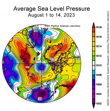
Sea Level Pressure for Arctic

Figure 2b. This plot shows average sea level pressure in the Arctic in millibars from August 1 to 14, 2023. Yellows and reds indicate high air pressure; blues and purples indicate low pressure.

Credit: NSIDC courtesy NOAA Earth System Research Laboratory Physical Sciences Laboratory
High-resolution image

Through the first half of August, air temperatures conditions at the 925 millibar level (about 2,500 feet above the surface) varied widely across the Arctic (Figure 2a). Temperatures prevailed at 1 to 3 degrees Celsius (2 to 5 degrees Fahrenheit) below average over the Pole and north of Greenland, while temperatures were above average over most of the rest of the Arctic Ocean. Conditions over the Barents Sea were unusually warm during the first two weeks of August, with temperatures up to 8 degrees Celsius (14 degrees Fahrenheit) above average. The Beaufort and Chukchi Sea regions saw temperatures 1 to 6 degrees Celsius (2 to 11 degrees Fahrenheit) above average.

The sea level pressure pattern during the first half of the month featured low pressure over the pole and high pressure elsewhere (Figure 2b). As noted above, a low-pressure system, a cyclone, did move in the Laptev Sea area on August 14, but the region was still under high pressure as averaged for August 1 to 14.

Extreme ice conditions in the Southern Ocean persist

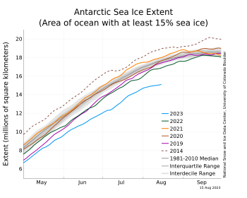
Antarctic sea ice extent graph for 2023 plus other years

Figure 3a. The graph above shows Antarctic sea ice extent as of August 15, 2023, along with daily ice extent data for four previous years and the record high year. 2023 is shown in blue, 2022 in green, 2021 in orange, 2020 in brown, 2019 in magenta, and 2014 in dashed brown. The 1981 to 2010 median is in dark gray. The gray areas around the median line show the interquartile and interdecile ranges of the data. Sea Ice Index data.

Credit: National Snow and Ice Data Center
High-resolution image

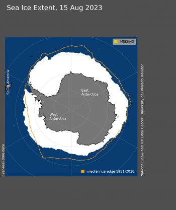
Antarctic sea ice extent map as of August 15, 2023

Figure 3b. Antarctic sea ice extent for August 15, 2023 was 15.12 million square kilometers (5.84 million square miles). The orange line shows the 1981 to 2010 average extent for that day. Sea Ice Index data. About the data

Credit: National Snow and Ice Data Center
High-resolution image

Record low levels of Antarctic sea ice extent have persisted and have even become more extreme. Since the beginning of August, the growth in extent has begun to level off (Figure 3a). Highly variable conditions are typical of Antarctic sea ice extent near the seasonal maximum, but the present situation is clearly remarkable. While there will likely be further increases in extent the second half of the month, close attention to the progression of ice growth or retreat is warranted.

On August 15, extent was 15.12 million square kilometers (5.84 million square miles) (Figure 3b), which is 2.54 million square kilometers (980,000 square miles) below the 1981 to 2010 average extent for August 15. Even more remarkable, this year’s extent on August 15 was 1.73 million square kilometers (670,000 square miles) below the previous record low for the date, in 1986. Ice extent is particularly low in the Ross Sea and eastern Weddell Sea sectors, but has recovered somewhat in the Bellingshausen Sea. The Amundsen Sea and western Bellingshausen Sea are now slightly above average.

Melt onset

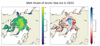
Melt onset for Arctic sea ice 2023

Figure 4. The map on the left shows the melt onset of Arctic Sea Ice for 2023. Different in 2023 melt onset date with the 1981 to 2010 melt date. Red indicates earlier than average melt onset; blue indicates later than average melt onset.

Credit: Data processed by Jeff Miller, NASA Goddard; image by Julienne Stroeve, NSIDC; data based on Markus et al. (2009)
High-resolution image

The onset of surface melt is a potential harbinger of ice conditions later in the melt season. When melt begins, the reflectivity, known as albedo, of the surface decreases, allowing more of the sun’s energy to be absorbed. This means more energy is available to promote further melting the ice and a greater potential for areas of sea ice to melt out completely by the end of summer. Melt onset data are based on the Markus et al. 2009 method, and were provided by Jeff Miller at NASA Goddard. This year, melt started 10 to 20 days earlier than average along the coastal seas around nearly all of the Arctic, while over the central Arctic, melt started 10 to 20 day later than average (Figure 4).

Hudson Bay

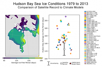
Figure 5. (a) The average ice-free period (sea ice concentration is continuously below 15%) for 1979-2013 in the Hudson Bay Complex based on the Bootstrap Algorithm applied to passive microwave satellite retrievals. (b) Comparison of the satellite record to 37 historical climate model simulations of the ice-free period averaged for the Hudson Bay Complex (1979-2013). Each model is represented by a single ensemble member. Credit: Alex Crawford, Univ. Manitoba and Annals of Glaciology.||Credit: |High-resolution image

Figure 5. The map of Hudson Bay Complex on the left shows the average ice-free period (sea ice concentration is continuously below 15 percent) from 1979 to 2013 based on the Bootstrap Algorithm applied to passive microwave satellite retrievals. The chart on the right compares the satellite record to 37 historical climate model simulations of the ice-free period averaged for the Hudson Bay Complex (1979 to 2013). Each model is represented by a single ensemble member.

Credit: Alex Crawford, University Manitoba and Crawford, A. D. et al. 2023
High-resolution image

As in many recent years, Hudson Bay melted out earlier than the 1981 to 2010 average date, and there is a trend toward a longer summer ice-free period. There is interest in knowing how long Hudson Bay will be seasonally ice free in the future. A recent study by Alex Crawford and colleagues at the University of Manitoba highlights a common problem in many climate models used to make future projections: The ice-free periods are too long (Figure 5). On average, models simulate sea ice retreating 19 days too early in summer and advancing 9 days too late in autumn, meaning the average model simulates an ice-free period that is about a month longer than is observed by satellite. After accounting for uncertainty in satellite observations, 73 percent (27 of 37) of models significantly overestimate the ice-free period. This performance is the worst for any Arctic sub-region.

The main culprit is how models simulate the atmosphere. Models that overestimate the ice-free period tend to depict overly warm conditions over Hudson Bay, especially in August to October. This warmth links back to winds blowing too often from the south and east. Extra warmth delays autumn freeze up, which leads to thinner ice that melts more readily in summer. Improving the atmospheric components of these models might improve the simulation of Hudson Bay sea ice and provide more confidence in projections of the future.

References

Crawford, A. D., E. Rosenblum, J. V. Lukovich, and J. C. Stroeve. 2023. Sources of Seasonal Sea Ice Bias for CMIP6 Models in the Hudson Bay ComplexAnnals of Glaciology, First View, 1-18, doi:10.1017/aog.2023.42.

Markus, T., J. C. Stroeve, and J. Miller. 2009. Recent changes in Arctic sea ice melt onset, freezeup, and melt season length. Journal Geophysical Research, 114, C12024, doi:10.1029/2009JC005436.


An odd summer

While large parts of the world saw record breaking heat in July, and Antarctic sea ice extent remained at record daily lows as assessed over the satellite record, Arctic sea ice extent for July was only the twelfth lowest in the satellite record. At month’s end, ice concentrations were low north of the Laptev Sea; however, the Northern Sea Route and the Northwest Passage retained considerable ice.

Overview of conditions

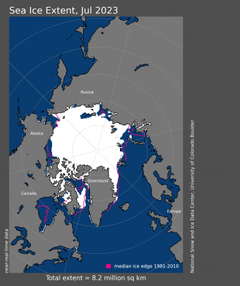
Arctic sea ice extent for July 2023

Figure 1a. Arctic sea ice extent for July 2023 was 8.18 million square kilometers (3.16 million square miles). The magenta line shows the 1981 to 2010 average extent for that month. Sea Ice Index data. About the data

Credit: National Snow and Ice Data Center
High-resolution image

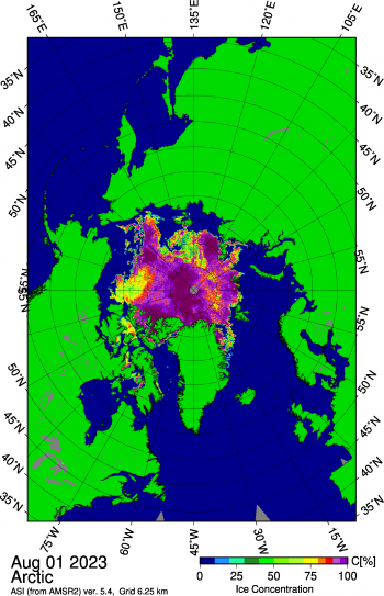
Figure 1b. This map shows a large opening in the East Siberian Sea as well as several smaller openings within the pack further north of the polynya, and areas of low concentration in the Beaufort Sea north of Alaska. Sea ice concentration data are from Advanced Microwave Scanning Radiometer 2 (AMSR2) imagery. Credit: University of Bremen

Figure 1b. This map shows a large opening on August 1, 2023, in the Laptev and East Siberian Seas and extensive open water north of Alaska and the Mackenzie River Delta. Sea ice concentration data are from Advanced Microwave Scanning Radiometer 2 (AMSR2) imagery.

Credit: University of Bremen
High-resolution image

For the month of July, Arctic sea ice extent declined at a pace of 93,300 square kilometers (36,000 square miles) per day, near the 1981 to 2010 average of 86,900 square kilometers (33,600 square miles) per day (Figure 1a). The July average Arctic sea ice extent of 8.18 million square kilometers (3.16 million square miles) was the twelfth lowest in the satellite record, and 1.29 million square kilometers (498,000 square miles) below the 1981 to 2010 reference period. By stark contrast, Antarctic sea ice extent remained far below previous record daily lows throughout the month. While there is speculation that a fundamental change in the Antarctic sea ice system is afoot, there is some evidence from early satellite data that extent may have been similarly low in 1966.

The sea ice concentration image on August 1, 2023, from the Advanced Microwave Scanning Radiometer 2 (AMSR2) offers a detailed view of Arctic sea ice conditions (Figure1b). Large parts of the Laptev and East Siberian seas are largely ice free, and a large area of fairly low ice concentration extends north of the Laptev Sea. However, ice is still present along much of the Northern Sea Route, noting of course that Russian ice breakers are quite capable of keeping routes open. The ice edge has retreated to well north of the Alaskan and Mackenzie Delta coasts, but it is clear that the southern (Amundsen’s) route through the Northwest Passage is still choked with ice. To date since July 1, 2.86 million square kilometers (1.10 million square miles) of sea ice have melted.

Conditions in context

Arctic sea ice extent compared to other years

Figure 2a. The graph above shows Arctic sea ice extent as of August 1 2023, along with daily ice extent data for four previous years and the record low year. 2023 is shown in blue, 2022 in green, 2021 in orange, 2020 in brown, 2019 in magenta, and 2012 in dashed brown. The 1981 to 2010 median is in dark gray. The gray areas around the median line show the interquartile and interdecile ranges of the data. Sea Ice Index data.

Credit: National Snow and Ice Data Center
High-resolution image

Average temp in Arctic July 2023

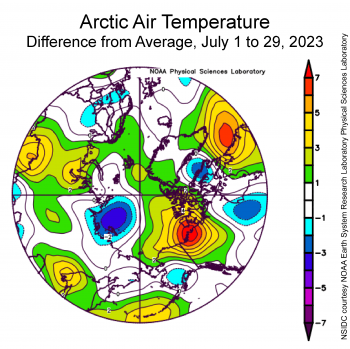
Figure 2b. This plot shows the departure from average air temperature in the Arctic at the 925 hPa level, in degrees Celsius, from July 1 to 29, 2023. Yellows and reds indicate higher than average temperatures; blues and purples indicate lower than average temperatures.

Credit: NSIDC courtesy NOAA Earth System Research Laboratory Physical Sciences Laboratory
High-resolution image

Sea level pressure for Arctic July 2023

Figure 2c. This plot shows average sea level pressure in the Arctic in millibars from July 1 to 29, 2023. Yellows and reds indicate high air pressure; blues and purples indicate low pressure.

Credit: NSIDC courtesy NOAA Earth System Research Laboratory Physical Sciences Laboratory
High-resolution image

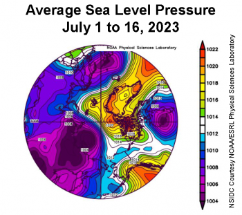
Air temperatures at the 925 hPa level (approximately 2,500 feet above the surface) averaged for July 2023 were with one exception unremarkable (Figure 2). This contrasts sharply with the record high global average surface air temperature (2 meters or 6.6 feet above the surface) for the month as shown in records compiled by NASA, the National Oceanic and Atmospheric Administration (NOAA) and other agencies. Arctic temperatures at the 925 hPa level were from 1 to 3 degrees Celsius (2 to 5 degrees Fahrenheit) above average across much of the Arctic Ocean but below average by 1 to 4 degrees Celsius (2 to 7 degrees Fahrenheit) over the Laptev Sea, which as noted above is largely ice free. The one area of pronounced warmth is centered over the Mackenzie River Delta, with temperatures up to 7 degrees Celsius (13 degrees Fahrenheit) above average. The atmospheric circulation pattern for the month was by contrast quite interesting, with low pressure over the Eurasian side of the Arctic and high pressure over the North American side (Figure 2c). As a result, there was a strong pressure gradient across the central Arctic Ocean extending to the east of Svalbard and then towards Iceland, pointing to strong winds and hence strong sea ice transport.

July 2023 compared to previous years

Linear trend of decline for July from 1979 to 2023

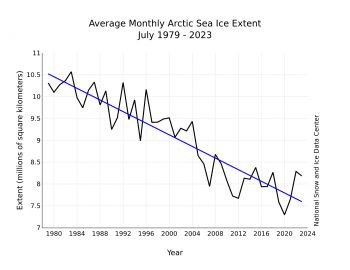
Figure 3. Monthly July ice extent for 1979 to 2023 shows a decline of 7.0 percent per decade.

Credit: National Snow and Ice Data Center
High-resolution image

The downward linear trend for Arctic sea ice extent in July over the 45-year satellite record is 66,500 square kilometers (25,700 square miles) per year, or 7.0 percent per decade relative to the 1981 to 2010 average (Figure 3). Based on the linear trend, since 1979, July has lost 2.92 million square kilometers (1.13 million square miles) of ice. This is roughly equivalent to four times the size of Texas.

An update on the Southern Hemisphere

Antarctic sea ice extent for July 2023

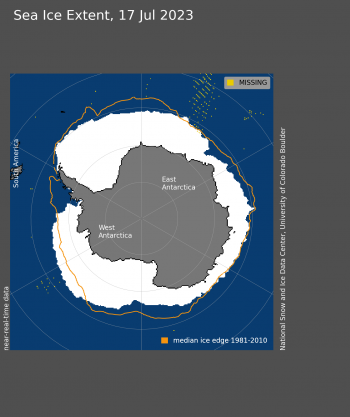
Figure 4a. Antarctic sea ice extent for July 2023 was 13.49 million square kilometers (5.21 million square miles). The magenta line shows the 1981 to 2010 average extent for that month. Sea Ice Index data. About the data

Credit: National Snow and Ice Data Center
High-resolution image

Antarctic sea ice extent for July 2023 compared to other years

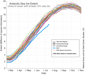
Figure 4b. The graph above shows Antarctic sea ice extent as of August 1, 2023, along with daily ice extent data for four previous years and the record high year. 2023 is shown in blue, 2022 in green, 2021 in orange, 2020 in brown, 2019 in magenta, and 2014 in dashed brown. The 1981 to 2010 median is in dark gray. The gray areas around the median line show the interquartile and interdecile ranges of the data. Sea Ice Index data.

Credit: National Snow and Ice Data Center
High-resolution image

While Arctic sea ice is in the midst of the melt season, Antarctic sea ice is growing, but only slowly for this time of year. Antarctic sea ice extent averaged for July was at a record low at 13.49 million square kilometers (5.21 million square miles), and 1.50 million square kilometers (579,000 square miles) below the previous satellite record low set in 2022 (Figure 4a and 4b). As discussed in the previous post, there is speculation that the Antarctic sea ice system has entered a new regime, in which ocean heat is now playing a stronger role in limiting autumn and winter ice growth and enhancing spring and summer melt.

While this very low extent has garnered much attention, as well as consternation, a study led by colleague Dave Gallaher several years ago provides evidence from early Nimbus satellite data that sea ice extent in the winter of 1966 may have rivaled the very low level seen today. There are caveats. First, the Nimbus data for 1966 is for August, not September, the month with the annual highest average extent in the Antarctic. Second, there is substantial uncertainty in the 1966 extent because of the limited data from the low resolution visible-band Nimbus images (notably cloud cover) and challenges in interpreting the imagery. The estimated August 1966 sea ice extent from Nimbus is 15.90 million square kilometers (6.14 million square miles). A simple projection, based on data through July 1, yields an August 2023 extent of August 15.07 million square kilometers (5.82 million square miles), still significantly lower than the 1966 data suggest. Despite these uncertainties, the Nimbus data is consistent with observations from the satellite passive microwave record that Antarctic sea ice extent is highly variable.

A second information source, from a reconstruction of Antarctic sea ice led by Ryan Fogt, a professor at Ohio University, suggests that the present level is well below anything seen since the earliest Southern Ocean weather observations, back to 1905. Fogt and colleagues first established how weather station data are correlated with observed sea ice extent from 1979 through 2020. Using this information together with weather station records that go back to the early 1900s, they deduce what sea ice extent was likely to have been between 1905 and 2020, along with what its variability was likely to have been.

Further reading

Fogt, R. L., A. M. Sleinkofer, M. N. Raphael, H. S. and Handcock. 2022a. A regime shift in seasonal total Antarctic sea ice extent in the twentieth centuryNature Climate Change 12, 54– 62. doi:10.1038/s41558-021-01254-9.

Gallaher, D. W., G. G. Campbell, W. N. and Meier. 2013. Anomalous variability in Antarctic sea ice extents during the 1960s with the use of Nimbus data. IEEE Journal of Selected Topics in Applied Earth Observations and Remote Sensing7(3), 881-887. doi:10.1109/JSTARS.2013.2264391.

Arctic, low. Antarctic, whoa.

Arctic sea ice continues to decline at a near-average pace, with ice extent twelfth lowest in the satellite record at this time. Antarctic sea ice by contrast is growing at far below-average rates and is at an unprecedently low level for this time of year relative to the 45-year data set.

Overview of conditions

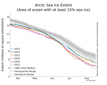
Figure 1a. The graph above shows Arctic sea ice extent as of July 17, 2023, along with daily ice extent data for four previous years and the record low year. 2023 is shown in blue, 2022 in green, 2021 in orange, 2020 in brown, 2019 in magenta, and 2012 in dashed brown. The 1981 to 2010 median is in dark gray. The gray areas around the median line show the interquartile and interdecile ranges of the data. Sea Ice Index data.||Credit: National Snow and Ice Data Center|High-resolution image

Figure 1a. The graph above shows Arctic sea ice extent as of July 17, 2023, along with daily ice extent data for four previous years and the record low year. 2023 is shown in blue, 2022 in green, 2021 in orange, 2020 in brown, 2019 in magenta, and 2012 in dashed brown. The 1981 to 2010 median is in dark gray. The gray areas around the median line show the interquartile and interdecile ranges of the data. Sea Ice Index data.

Credit: National Snow and Ice Data Center
High-resolution image

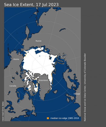
Figure 1b. Arctic sea ice extent for July 17, 2023 was 8.27 million square kilometers (3.19 million square miles). The orange line shows the 1981 to 2010 average extent for that day. Sea Ice Index data. About the data||Credit: National Snow and Ice Data Center|High-resolution image

Figure 1b. Arctic sea ice extent for July 17, 2023 was 8.27 million square kilometers (3.19 million square miles). The orange line shows the 1981 to 2010 average extent for that day. Sea Ice Index data. About the data

Credit: National Snow and Ice Data Center
High-resolution image

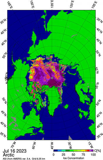
Figure 1c. This map shows a large opening in the East Siberian Sea as well as several smaller openings within the pack further north of the polynya, and areas of low concentration in the Beaufort Sea north of Alaska. Sea ice concentration data are from Advanced Microwave Scanning Radiometer 2 (AMSR2) imagery. ||Credit: University of Bremen|High-resolution image

Figure 1c. This map shows a large opening in the East Siberian Sea as well as several smaller openings within the pack further north of the polynya, and areas of low concentration in the Beaufort Sea north of Alaska. Sea ice concentration data are from Advanced Microwave Scanning Radiometer 2 (AMSR2) imagery.

Credit: University of Bremen
High-resolution image

During the first half of July, Arctic sea ice extent declined at a near-average pace of 81,800 square kilometers (31,600 square miles) per day, just below the 1981 to 2010 average of 86,200 square kilometers (33,300 square miles) per day (Figure 1a). As of this post, sea ice in the Arctic is about 1.31 million square kilometers (506,000 square miles) below the 1981 to 2010 reference period, and ice extent for July 17 is twelfth lowest in the 45-year satellite record.

However, several regions have far below average extent, including Hudson Bay, which according to the satellite data became ice-free quite early this year, the Kara Sea, and the Beaufort Sea (Figure 1b). Sea ice extent and concentration from the higher-resolution Advanced Microwave Scanning Radiometer 2 (AMSR2) data processed by the University of Bremen shows a large opening in the East Siberian Sea as well as several smaller openings within the pack further north of the polynya, and areas of low concentration in the Beaufort Sea north of Alaska (Figure 1c). A large polynya has also formed in the Kara Sea near Severnaya Zemlya.

To date since June 1, 3.82 million square kilometers (1.47 million square miles) of ice have melted.

Conditions in context

Figure 2a. This plot shows the departure from average air temperature in the Arctic at the 925 hPa level, in degrees Celsius, for July 1 to 16, 2023. Yellows and reds indicate higher than average temperatures; blues and purples indicate lower than average temperatures. ||Credit: NSIDC courtesy NOAA Earth System Research Laboratory Physical Sciences Laboratory|High-resolution image

Figure 2a. This plot shows the departure from average air temperature in the Arctic at the 925 hPa level, in degrees Celsius, for July 1 to 16, 2023. Yellows and reds indicate higher than average temperatures; blues and purples indicate lower than average temperatures.

Credit: NSIDC courtesy NOAA Earth System Research Laboratory Physical Sciences Laboratory
High-resolution image

Figure 2b. This plot shows average sea level pressure in the Arctic in millibars for July 1 to 16, 2023. Yellows and reds indicate high air pressure; blues and purples indicate low pressure. ||Credit: NSIDC courtesy NOAA Earth System Research Laboratory Physical Sciences Laboratory|High-resolution image

Figure 2b. This plot shows average sea level pressure in the Arctic in millibars for July 1 to 16, 2023. Yellows and reds indicate high air pressure; blues and purples indicate low pressure.

Credit: NSIDC courtesy NOAA Earth System Research Laboratory Physical Sciences Laboratory
High-resolution image

Air temperatures at the 925 millibar level (approximately 2,500 feet above the surface) over the Arctic Ocean for the first half of July ranged from 3 to 6 degrees Celsius (5 to 11 degrees Fahrenheit) below average over the Laptev Sea, contrasting with above-average values of 2 to 7 degrees Celsius (4 to 13 degrees Fahrenheit) in a band extending from northeast of Greenland to the Beaufort Sea off the coast of Canada (Figure 2a). Particularly warm conditions were the rule near the MacKenzie River delta. Another area of warm conditions existed in the southern Baffin Bay and the Labrador coast. The atmospheric circulation for the first half of July was characterized by generally low pressure over the Siberian side of the Arctic Ocean, and high air pressure in a broad area covering Greenland, Fram Strait, and the northern Barents Sea (Figure 2b).

Smoke on the Arctic water

Figure 3. This true color composite image from the NASA Moderate Resolution Imaging Spectroradiometer (MODIS) on July 16 shows the North Pole at the center of the image, with Greenland pointing down. ||Credit: NASA Worldview |High-resolution image

Figure 3. This true color composite image from the NASA Moderate Resolution Imaging Spectroradiometer (MODIS) on July 16 shows the North Pole at the center of the image, with Greenland pointing down.

Credit: NASA Worldview
High-resolution image

A relatively clear-sky image from the NASA Moderate Resolution Imaging Spectroradiometer (MODIS) sensor on July 16 provides a visual glimpse of the condition of sea ice and surrounding areas (Figure 3). Open water is visible in the East Siberian Sea with lower concentration ice extending toward the east, confirming the concentration pattern seen in the AMSR2 imagery (Figure 1c). Another interesting feature of the MODIS image is the wildfire smoke over Canada, which has drifted into the US causing air quality issues. There is also wildfire smoke in eastern Siberia. Some smoke from both areas have drifted over coastal sea ice areas. Such smoke can reduce the amount of solar energy reaching the sea ice surface, which could slow melt. However, as smoke particles fall onto the ice, they darken the ice surface, causing it to absorb more of the sun’s energy, which would enhance melt. Given the limited region of sea ice covered by smoke, any effect is unlikely to substantially impact this year’s melt.

Antarctic sea ice extent

Figure 4a. The graph above shows sea ice extent for February 18 to November 2 for every year in the 45-year satellite data set, with 2023 shown in blue. The dashed red line is the 2022 ice extent, which was the former record summer minimum low before 2023.||Credit: Ted Scambos, Cooperative Institute for Research in Environmental Sciences|High-resolution image

Figure 4a. The graph above shows sea ice extent for February 18 to November 2 for every year in the 45-year satellite data set, with 2023 shown in blue. The dashed red line is the 2022 ice extent, which was the former record summer minimum low before 2023.

Credit: Ted Scambos, Cooperative Institute for Research in Environmental Sciences
High-resolution image

Figure 4b. Antarctic sea ice extent for July 17, 2023 was 13.45 million square kilometers (5.19 million square miles). The orange line shows the 1981 to 2010 average extent for that day. Sea Ice Index data. About the data||Credit: National Snow and Ice Data Center|High-resolution image

Figure 4b. Antarctic sea ice extent for July 17, 2023 was 13.45 million square kilometers (5.19 million square miles). The orange line shows the 1981 to 2010 average extent for that day. Sea Ice Index data. About the data

Credit: National Snow and Ice Data Center
High-resolution image

Figure 4c. This figure shows the monthly Antarctic sea ice extent (SIE) anomaly (difference relative to the 1981 to 2010 average) for January 1979 to July 2023. The x-axis shows years, 1979 through 2023. The y-axis shows months of the year from January (bottom) to December (top). Red shades indicate higher than average extent, while blue shades indicate lower than average extent, with darker shades corresponding to larger differences. ||Credit: Julienne Stroeve, National Snow and Ice Data Center|High-resolution image

Figure 4c. This figure shows the monthly Antarctic sea ice extent (SIE) anomaly (difference relative to the 1981 to 2010 average) for January 1979 to July 2023. The x-axis shows years, 1979 through 2023. The y-axis shows months of the year from January (bottom) to December (top). Red shades indicate higher than average extent, while blue shades indicate lower than average extent, with darker shades corresponding to larger differences.

Credit: Julienne Stroeve, National Snow and Ice Data Center
High-resolution image

Sea ice surrounding the Antarctic continent continues to be exceptionally low. Antarctic ice extent as of mid-July is more than 2.6 million square kilometers (1.00 million square miles) below the 1981 to 2010 average, an area nearly as large as Argentina or the combined areas of Texas, California, New Mexico, Arizona, Nevada, Utah, and Colorado. It is 1.6 million square kilometers (618,000 square miles) below the previous record low extent for the date, set in 2022 (Figure 4a). Low ice extent is present nearly everywhere, but particularly in the northern Weddell Sea, western Ross Sea, and southern Bellingshausen Sea (Figure 4b). Above average extent is prevalent in the Amundsen Sea.

The research community has been discussing the causes for the sudden turnabout in Antarctic sea ice extent, from a weakly positive linear trend from 1978 to 2015 to a strongly negative trend since 2016; and the events of 2022 and 2023 have garnered much attention. Many recent studies point to changing conditions in the upper ocean layer. Warm water from the north has mixed into this layer, which tends to increase the stratification of the ocean. This appears to coincide with when sea ice went from record high extents to low extents beginning in September 2016, and still lower extents in 2023.

Further reading

Eayrs, C., X. Li, M. N. Raphael, and D. M. Holland. 2021. Rapid decline in Antarctic sea ice in recent years hints at future changeNature Geoscience. doi:10.1038/s41561-021-00768-3

Mid-summer bliss

The longest day of summer has come and gone, and summer melt is in full swing, with the pace of ice loss overall about average for this time of year. Arctic sea ice extent for June was not exceptionally low compared to other recent years. Antarctic sea ice extent continues to track at record low values.

Overview of conditions

Figure 1a. Arctic sea ice extent for June 2023 was 10.96 million square kilometers (4.23 million square miles). The magenta line shows the 1981 to 2010 average extent for that month. Sea Ice Index data. About the data||Credit: National Snow and Ice Data Center|High-resolution image

Figure 1a. Arctic sea ice extent for June 2023 was 10.96 million square kilometers (4.23 million square miles). The magenta line shows the 1981 to 2010 average extent for that month. Sea Ice Index data. About the data

Credit: National Snow and Ice Data Center
High-resolution image

Figure 1b. The graph above shows Arctic sea ice extent as of July 5, 2023, along with daily ice extent data for four previous years and the record low year. 2023 is shown in blue, 2022 in green, 2021 in orange, 2020 in brown, 2019 in magenta, and 2012 in dashed brown. The 1981 to 2010 median is in dark gray. The gray areas around the median line show the interquartile and interdecile ranges of the data. Sea Ice Index data.||Credit: National Snow and Ice Data Center|High-resolution image

Figure 1b. The graph above shows Arctic sea ice extent as of July 5, 2023, along with daily ice extent data for four previous years and the record low year. 2023 is shown in blue, 2022 in green, 2021 in orange, 2020 in brown, 2019 in magenta, and 2012 in dashed brown. The 1981 to 2010 median is in dark gray. The gray areas around the median line show the interquartile and interdecile ranges of the data. Sea Ice Index data.

Credit: National Snow and Ice Data Center
High-resolution image

Average Arctic sea ice extent during June 2023 was 10.96 million square kilometers (4.23 million square miles) (Figure 1a), the thirteenth lowest June in the satellite record. The average extent was 800,000 square kilometers (309,000 square miles) below the 1981 to 2010 average and 550,000 square kilometers (212,000 square miles) above the record low June extent, which occurred in 2016.

Through much of June 2023, extent declined faster than the 1981 to 2010 average (Figure 1b). On average, based on the 1981 to 2010 mean, about 1.69 million square kilometers (653,000 square miles) of ice is lost in June, roughly the size of Alaska. This summer, 2.30 million square kilometers of ice melted (880,000 square miles). In regions which normally lose sea ice this time of year, the rate of ice loss was faster than average. This includes the Beaufort, Chukchi, Laptev, Kara and East Greenland Seas. In the Sea of Okhotsk and the Bering and Barents Seas, where ice retreat generally starts before June, the ice loss has been slower than average. At the end of June, total sea ice extent was below that in 2022, but higher than in 2019 and 2021.

Conditions in context

Figure 2a. This plot shows the departure from average air temperature in the Arctic at the 925 hPa level, in degrees Celsius, for June 2023. Yellows and reds indicate higher than average temperatures; blues and purples indicate lower than average temperatures. ||Credit: NSIDC courtesy NOAA Earth System Research Laboratory Physical Sciences Laboratory|High-resolution image

Figure 2a. This plot shows the departure from average air temperature in the Arctic at the 925 hPa level, in degrees Celsius, for June 2023. Yellows and reds indicate higher than average temperatures; blues and purples indicate lower than average temperatures.

Credit: NSIDC courtesy NOAA Earth System Research Laboratory Physical Sciences Laboratory
High-resolution image

Figure 2b. This plot shows average sea level pressure in the Arctic in millibars for June 2023. Yellows and reds indicate high air pressure; blues and purples indicate low pressure. ||Credit: NSIDC courtesy NOAA Earth System Research Laboratory Physical Sciences Laboratory|High-resolution image

Figure 2b. This plot shows average sea level pressure in the Arctic in millibars for June 2023. Yellows and reds indicate high air pressure; blues and purples indicate low pressure.

Credit: NSIDC courtesy NOAA Earth System Research Laboratory Physical Sciences Laboratory
High-resolution image

Air temperatures at the 925 millibar level (approximately 2,500 feet above the surface) over the Arctic Ocean were mixed (Figure 2a). Above average temperatures of 1 to 4 degrees Celsius (2 to 7 degrees Fahrenheit) were found just off the coast in the Laptev Sea, the southern Beaufort Sea off the coast of Canada, and in the East Greenland Sea and stretching towards Svalbard. North of Alaska and in the East Siberian Sea, temperatures were 1 to 3 degrees Celsius (2 to 5 degrees Fahrenheit) below average.

Below-average sea level pressure dominated Eurasia in June, with low pressure extending over much of the Arctic Ocean (Figure 2b). Coupled with above-average sea level pressure over Scandinavia, this pressure pattern fostered relatively cold Arctic air reaching Novaya Zemlya and the coastal areas of the Kara Sea, resulting in temperatures just slightly below average for this time of year.

June 2023 compared to previous years

Figure 3. Monthly June sea ice extent for 1979 to 2023 shows a decline of 3.8 percent per decade.||Credit: National Snow and Ice Data Center| High-resolution image

Figure 3. Monthly June sea ice extent for 1979 to 2023 shows a decline of 3.8 percent per decade.

Credit: National Snow and Ice Data Center
High-resolution image

The downward linear trend in Arctic sea ice extent in June over the 45-year satellite record is 44,300 square kilometers (17,100 square miles) per year, or 3.8 percent per decade relative to the 1981 to 2010 average (Figure 3). Based on the linear trend, since 1979, June has lost 1.99 million square kilometers (768,000 square miles) of ice. This is roughly equivalent to the size of Mexico.

An update on sea ice age

Figure 4. The top maps show sea ice age for the week of February 26 to March 4 for (a) 1985 and (b) 2023. The bottom graph is a time series of the percent of the sea ice extent within the Arctic Ocean domain (inset map) for the week of February 26 to March 4, 1985, through 2023; color categories are the same as in the maps. ||Credit: Data and images are from NSIDC EASE-Grid Sea Ice Age, Version 4 (Tschudi et al., 2019a) and Quicklook Arctic Weekly EASE-Grid Sea Ice Age, Version 1.| High-resolution image

Figure 4. This map shows sea ice age for the week of June 25 to July 1, 2023. Dark blue represents up to one-year-old ice, light blue represents one- to two-year-old ice, green represents two- to three-year-old ice, orange represents three- to four-year-old ice, and red represents ice more than four years old.

Credit: Data and images are from NSIDC EASE-Grid Sea Ice Age, Version 4 (Tschudi et al., 2019a) and Quicklook Arctic Weekly EASE-Grid Sea Ice Age, Version 1.
High-resolution image

An update of sea ice age reveals extensive areas of first-year ice extending far north from the Siberian coast. While first-year ice is generally thinner and more prone to melt completely than older ice, the extensive first year ice located in high northern latitudes may not melt out completely. An area of multiyear ice, much of it 4+-years old residing in the Beaufort Sea region, will likely survive the summer melt season.

Solar geoengineering studies highlight the urgent need to limit global warming to 1.5 degrees Celsius

Figure 5. This figure shows interactions potentially resulting in residual changes in the polar regions under global Stratospheric Aerosol Injection (SAI), relative to a world at the same global mean temperature without SAI. The figure does not show the first order effect of SAI, which is to cool the planet and reverse the effects of climate change, but only the residual changes. This is a simplified version of the full figure in Duffey et al. (2023). See the full figure for individual studies supporting each link and the definitions of “radiative” and “dynamic” effects. Where studies disagree on the sign of a change, the number supporting the statement in the box is indicated in brackets. Where interactions have opposite impacts on residual changes, this is indicated by color coding. ||Credit: Alistair Duffey | High-resolution image

Figure 5. This figure shows interactions potentially resulting in residual changes in the polar regions under global Stratospheric Aerosol Injection (SAI), relative to a world at the same global mean temperature without SAI. The figure does not show the first order effect of SAI, which is to cool the planet and reverse the effects of climate change, but only the residual changes. This is a simplified version of the full figure in Duffey et al. (2023). See the full figure for individual studies supporting each link and the definitions of “radiative” and “dynamic” effects. Where studies disagree on the sign of a change, the number supporting the statement in the box is indicated in brackets. Where interactions have opposite impacts on residual changes, this is indicated by color coding.

Credit: Alistair Duffey
High-resolution image

As new studies come out suggesting that the Arctic Ocean may witness its first ice-free summer by the 2030s, solar geoengineering studies have been exploring the potential benefits and pitfalls of reducing incoming sunlight and thus slowing Arctic warming. A review paper co-led by NSIDC scientist Julienne Stroeve explored the impacts of stratospheric aerosol injection on polar climate, considering impacts of both local and global injection of reflective sulfate aerosols into the stratosphere.

Without local injection of aerosols in the Arctic, cooling will not be as effective. However, any consideration of adding aerosols to the stratosphere to reduce incoming sunlight must be balanced by potential impacts on other aspects of the climate system, such as precipitation. If aerosols were only injected into the Arctic for example, drying in Northern Hemisphere lower latitude regions may occur. Furthermore, since the Arctic is dark or mostly dark for up to half of the year, the direct radiative effects of aerosol injection (i.e. blocking of sunlight) will be seasonally dependent. However, stratospheric heating from aerosol injection during the dark period may result in winter-time warming over high-latitude areas.

There are also potential impacts on weather and ocean circulation patterns (Figure 5). This could include more melting from the Antarctic ice shelves, thereby increasing Antarctic’s contribution to sea level rise. Atmospheric responses must be viewed with caution as the sensitivity of Arctic to changes in atmospheric circulation in climate models used for these types of assessments is not realistically simulated.

Antarctic extent remains low

Figure 5a. Antarctic sea ice extent for June 2023 was 11.02 million square kilometers (4.25 million square miles). The magenta line shows the 1981 to 2010 average extent for that month. Sea Ice Index data. About the data||Credit: National Snow and Ice Data Center|High-resolution image

Figure 6a. Antarctic sea ice extent for June 2023 was 11.02 million square kilometers (4.25 million square miles). The magenta line shows the 1981 to 2010 average extent for that month. Sea Ice Index data. About the data

Credit: National Snow and Ice Data Center
High-resolution image

Figure 6b. This plot shows the departure from average sea level pressure in the Antarctic in millibars for June 1, 2023 to June 30, 2023. Yellows and reds indicate high air pressure; blues and purples indicate low pressure. ||Credit: NSIDC courtesy NOAA Earth System Research Laboratory Physical Sciences Laboratory|High-resolution image

Figure 6b. This plot shows the departure from average sea level pressure in the Antarctic in millibars for June 1, 2023 to June 30, 2023. Yellows and reds indicate high air pressure; blues and purples indicate low pressure.

Credit: NSIDC courtesy NOAA Earth System Research Laboratory Physical Sciences Laboratory
High-resolution image

The total ice extent in the Antarctic is continuing to track at extreme record low levels, with departures from the long-term average of more than four standard deviations. Sea ice extent is below average everywhere except in the northern Amundsen Sea where it is more extensive than average (Figure 6a). In the Indian Ocean sector, ice extent is near average to slightly below.

The dramatically slower pace of ice growth through the 2023 autumn and early winter is a topic of intense research. Among the most likely causes are warmer ocean conditions in the polar water layer. This layer of colder, slightly less saline seawater is usually at or very near the freezing point. A small temperature increase, from mixing upward from deeper ocean layers or from warmer ocean surface water to the north, could slow the formation of new sea ice during autumn and winter. Under typical conditions, the polar water, a layer of several tens of meters thickness in the sea ice regions of both poles, is both slightly fresher and less dense than the underlying ocean waters, which leads to strong stratification of the topmost waters. However, if warm ocean water from just north of the surface extent of the cold water has been mixed into the polar water, it reduces this density contrast, and this reduces the stratification and allows warmth to more easily mix upward from below, further increasing the heat in the upper ocean layer and prolonging the period of reduced ice growth.

A further contributing factor for the southern Bellingshausen Sea region is the persistently strong and eastward position of the Amundsen Sea Low. This is driving warm winds southward along the western Peninsula, and across the Peninsula (Figure 6b), in both cases suppressing ice growth, and moving ice in the northwestern Weddell eastward.

Trying to measure sea ice during a record low ice cover year of the Antarctic

Figure 6. This photo shows the Ku- and Ka-band radar being deployed over newly forming sea ice off the coast of the Antarctic Peninsula near Rothera Station. ||Credit: X| High-resolution image

Figure 7. This photo shows the Ku- and Ka-band radar being deployed over newly forming sea ice off the coast of the Antarctic Peninsula near Rothera Station.

Credit: Vishnu Nandan, University of Manitoba
High-resolution image

The Antarctic Peninsula is the fastest warming region in the southern hemisphere, and this year its western coast is experiencing particularly low sea ice extent, contributing to the record low extent for the Antarctic as a whole. As part of a joint project between the University of Manitoba and a United Kingdom-led Drivers and Effects of Fluctuations in sea Ice in the ANTarctic (DEFIANT) project, Vishnu Nandan and Robbie Mallett from the University of Manitoba are spending the winter at the UK’s Rothera Base near the Peninsula where they are monitoring thin ice cover with a crane-mounted dual-frequency radar. This instrument mimics satellite-mounted radars such as CryoSat-2, Ka-band Altimeter (AltiKa), and the European Space Agency’s forthcoming Copernicus Polar Ice and Snow Topography Altimeter (CRISTAL) mission. It was previously deployed on the year-long Multidisciplinary drifting Observatory for the Study of Arctic Climate (MOSAiC) expedition in 2019 and 2020.

By scanning different ice types from a range of heights, the team’s previous surface-based observations are now being contextualized with regard to airborne and satellite platforms. Over the rest of the winter, Nandan and Mallett will perform sled-based transects of sea ice with the radar, investigating snow properties and their contribution to uncertainties in satellite-estimates of sea ice thickness. Snow remains one of the largest contributors in this respect, and results of DEFIANT’s field campaigns will provide valuable knowledge ahead of the European Space Agency CRISTAL’s anticipated launch in 2027.

Further reading

Duffey, A., P. Irvine, M. Tsamados, and J. Stroeve. 2023. Solar geoengineering in the polar regions: A reviewEarth’s Future, 11, e2023EF003679. doi:10.1029/2023EF003679

Kim, Y. H., S. K. Min, N. P. Gillett, et al. 2023. Observationally-constrained projections of an ice-free Arctic even under a low emission scenarioNature Communications. doi:10.1038/s41467-023-38511-8

Tschudi, M., W. N. Meier, and J. S. Stewart. 2019. Quicklook Arctic Weekly EASE-Grid Sea Ice Age, Version 1 [Data Set]. Boulder, Colorado USA. NASA National Snow and Ice Data Center Distributed Active Archive Center, doi:10.5067/2XXGZY3DUGNQ

Topál, D., and Q. Ding. 2023. Atmospheric circulation-constrained model sensitivity recalibrates Arctic climate projectionsNature Climate Change. doi:10.1038/s41558-023-01698-1


Springing into summer

The seasonal decline in Arctic sea ice extent was moderate through much of May before picking up pace over the last few days of the month. Meanwhile, Antarctic sea ice extent remained far below previous satellite-era record lows for this time of year.

Overview of conditions

Figure 1a. Arctic sea ice extent for May 2023 was 12.83 million square kilometers (4.95 million square miles). The magenta line shows the 1981 to 2010 average extent for that month. Sea Ice Index data. About the data||Credit: National Snow and Ice Data Center|High-resolution image

Figure 1a. Arctic sea ice extent for May 2023 was 12.83 million square kilometers (4.95 million square miles). The magenta line shows the 1981 to 2010 average extent for that month. Sea Ice Index data. About the data

Credit: National Snow and Ice Data Center
High-resolution image

Figure 1b. The graph above shows Arctic sea ice extent as of June 4, 2023, along with daily ice extent data for four previous years and the record low year. 2023 is shown in blue, 2022 in green, 2021 in orange, 2020 in brown, 2019 in magenta, and 2012 in dashed brown. The 1981 to 2010 median is in dark gray. The gray areas around the median line show the interquartile and interdecile ranges of the data. Sea Ice Index data.||Credit: National Snow and Ice Data Center|High-resolution image

Figure 1b. The graph above shows Arctic sea ice extent as of June 4, 2023, along with daily ice extent data for four previous years and the record low year. 2023 is shown in blue, 2022 in green, 2021 in orange, 2020 in brown, 2019 in magenta, and 2012 in dashed brown. The 1981 to 2010 median is in dark gray. The gray areas around the median line show the interquartile and interdecile ranges of the data. Sea Ice Index data.

Credit: National Snow and Ice Data Center
High-resolution image

Average Arctic sea ice extent during May 2023 was 12.83 million square kilometers (4.95 million square miles) (Figure 1a), the thirteenth lowest May in the satellite record. The average extent was 460,000 square kilometers (178,000 square miles) below the 1981 to 2010 average and 910,000 square kilometers (351,000 square miles) above the record low May extent, which occurred in 2016.

Through much of May, extent declined slightly slower than the 1981 to 2010 average (Figure 1b). From May 1 to May 24, extent dropped 963,000 square kilometers (372,000 square miles), compared to 1.12 million square kilometers (432,000 square miles) over the same interval in the 1981 to 2010 average. However, during the last week of the month, the rate of ice loss increased. Overall, the Arctic lost 452,000 square kilometers (175,000 square miles) of ice from May 24 to May 31, compared the 1981 to 2010 average of 279,000 square kilometers (108,000 square miles) during the same interval. The late increase in extent loss dropped the extent below the interdecile range after spending most of the month just above the lower part of the interdecile range.

Conditions in context

Figure 2a. This plot shows the departure from average air temperature in the Arctic at the 925 hPa level, in degrees Celsius, for May 2023. Yellows and reds indicate higher than average temperatures; blues and purples indicate lower than average temperatures. ||Credit: NSIDC courtesy NOAA Earth System Research Laboratory Physical Sciences Laboratory|High-resolution image

Figure 2a. This plot shows the departure from average air temperature in the Arctic at the 925 hPa level, in degrees Celsius, for May 2023. Yellows and reds indicate higher than average temperatures; blues and purples indicate lower than average temperatures.

Credit: NSIDC courtesy NOAA Earth System Research Laboratory Physical Sciences Laboratory
High-resolution image

Figure 2b. This plot shows average sea level pressure in the Arctic in millibars for May 2023. Yellows and reds indicate high air pressure; blues and purples indicate low pressure. ||Credit: NSIDC courtesy NOAA Earth System Research Laboratory Physical Sciences Laboratory|High-resolution image

Figure 2b. This plot shows average sea level pressure in the Arctic in millibars for May 2023. Yellows and reds indicate high air pressure; blues and purples indicate low pressure.

Credit: NSIDC courtesy NOAA Earth System Research Laboratory Physical Sciences Laboratory
High-resolution image

Air temperatures at the 925 millibar level (approximately 2,500 feet above the surface) were 1 to 4 degrees Celsius (2 to 7 degrees Fahrenheit) below average over much of the Arctic Ocean for the month as a whole, except the Barents, Kara, and Beaufort Seas, where temperatures were 2 to 6 degrees Celsius (4 to 11 degrees Fahrenheit) above average (Figure 2a). Hudson Bay was also warmer than average, especially in the northwest part of the bay where temperatures were up to 8 degrees Celsius (14 degrees Fahrenheit) above average. Most of the Arctic Ocean in May was dominated by below average sea level pressure, as much as 10 millibars below average north of the Laptev Sea (Figure 2b). This type of pattern is known to be generally associated with below average air temperatures over the Arctic Ocean. By contrast, the unusually warm conditions over Hudson Bay can be linked to high sea level pressure (an anticyclonic circulation).

May 2023 compared to previous years

Figure 3. Monthly May sea ice extent for 1979 to 2023 shows a decline of 2.4 percent per decade.||Credit: National Snow and Ice Data Center| High-resolution image

Figure 3. Monthly May sea ice extent for 1979 to 2023 shows a decline of 2.4 percent per decade.

Credit: National Snow and Ice Data Center
High-resolution image

The downward linear trend in Arctic sea ice extent in May over the 45-year satellite record is 32,300 square kilometers (12,500 square miles) per year, or 2.4 percent per decade relative to the 1981 to 2010 average (Figure 3). Based on the linear trend, since 1979, May has lost 1.42 million square kilometers (548,000 square miles) of ice. This is roughly equivalent to four times the size of Germany.

Antarctic extent remains low

Figure 4a. The graph above shows Antarctic sea ice extent as of June 4, 2023, along with daily ice extent data for four previous years and the record high year. 2023 is shown in blue, 2022 in green, 2021 in orange, 2020 in brown, 2019 in magenta, and 2014 in dashed brown. The 1981 to 2010 median is in dark gray. The gray areas around the median line show the interquartile and interdecile ranges of the data. Sea Ice Index data.||Credit: National Snow and Ice Data Center|High-resolution image

Figure 4a. The graph above shows Antarctic sea ice extent as of June 4, 2023, along with daily ice extent data for four previous years and the record high year. 2023 is shown in blue, 2022 in green, 2021 in orange, 2020 in brown, 2019 in magenta, and 2014 in dashed brown. The 1981 to 2010 median is in dark gray. The gray areas around the median line show the interquartile and interdecile ranges of the data. Sea Ice Index data.

Credit: National Snow and Ice Data Center
High-resolution image

Figure 4b. Antarctic sea ice extent for May 2023 was 8.36 million square kilometers (3.23 million square miles). The magenta line shows the 1981 to 2010 average extent for that month. Sea Ice Index data. About the data||Credit: National Snow and Ice Data Center|High-resolution image

Figure 4b. Antarctic sea ice extent for May 2023 was 8.36 million square kilometers (3.23 million square miles). The magenta line shows the 1981 to 2010 average extent for that month. Sea Ice Index data. About the data

Credit: National Snow and Ice Data Center
High-resolution image

Down south, Antarctic sea ice extent is at record low levels as assessed over the satellite record since 1978. The Antarctic winter is approaching, so May and June are months of large increases in extent, but this year, extent is far lower than average for May (Figure 4a). Sea ice extent was particularly low in the Bellingshausen Sea, Weddell Sea, and western Ross Sea regions; only the central Amundsen and Eastern Ross Seas were above the typical late May ice extent (Figure 4b).

In an average (1981 to 2010) May, Antarctic extent increases by 3.25 million square kilometers (1.25 million square miles). This May, the increase was only 2.87 million square kilometers (1.11 million square miles). As of May 31, sea ice extent is approximately 700,000 square kilometers (270,000 square miles) below the previous daily record lows, which occurred in in 1980, 2017, and 2019. (Please note that 1986 values are affected by a no-data period from the satellites we use).

The May 2023 sea ice extent continues the very low ice extent conditions seen throughout most of 2022, and generally low ice extents since 2016. For May 2023, weather conditions have been marked by above average air temperatures at the 925-millibar level of up to 4 degrees Celsius (7 degrees Fahrenheit) over the Weddell Sea extending over the Peninsula, and additionally a region north of Wilkes Land. Cool conditions prevailed over the Amundsen Sea, around 4 degrees Celsius below average (7 degrees Fahrenheit). Air pressure patterns for May indicate an especially strong Amundsen Sea Low (12 millibars below the 1991 to 2020 average), shifted somewhat eastward of its typical location. For 2023 to date, the conditions are much the same over the five months so far, with air temperatures up to 2 degrees Celsius above average (4 degrees Fahrenheit) over the Weddell Sea and the  Peninsula, and a 9-millibar below-average Amundsen Sea Low centered in the far southeastern Bellingshausen Sea, well to the east of its typical location.

Sea Ice Outlook begins another year

Over the past 15 years, the Sea Ice Outlook has been a community effort to improve prediction of Arctic September sea ice extent. The Outlook submissions are due June 12. The Outlook is managed by the Arctic Consortium of the United States (ARCUS) and is currently funded by the National Science Foundation.