In the last few days, the decline in Arctic sea ice extent has slowed. NSIDC data show Arctic sea ice extent currently at the second-lowest levels in the satellite record.
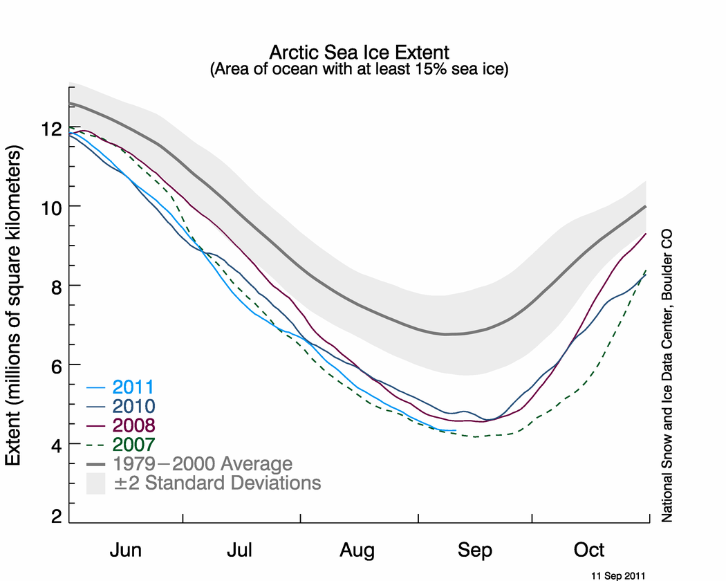 Figure 1. The graph above shows ice extent this year, along with daily ice extents for the previous three lowest extent years. Light blue indicates 2011, dashed green shows 2007, dark blue shows 2010, purple shows 2008, and dark gray shows the 1979 to 2000 average. The gray area around the average line shows the two standard deviation range of the data. Sea Ice Index data. About the data. —Credit: National Snow and Ice Data Center
High-resolution image
Overview of conditions
On September 10, Arctic sea ice extent was 4.34 million square kilometers (1.68 million square miles). This was 110,000 square kilometers (42,500 square miles) above the 2007 value on the same date. The record minimum Arctic sea ice extent, recorded in 2007, was 4.17* million square kilometers (1.61 million square miles).
The rate of decline has flattened considerably the last few days: Arctic sea ice is likely near its minimum value for the year. However, weather patterns could still push the ice extent lower. NSIDC scientists will make an announcement when ice extent has stopped declining and has expanded for several days in a row, indicating that the Arctic sea ice has reached its lowest extent for the year and has begun freezing over. During the first week of October, after data are processed and analyzed for the month of September, NSIDC scientists will issue a more detailed analysis of this year’s melt season and the state of the sea ice.
NSIDC’s sea ice data come from the Special Sensor Microwave Imager/Sounder (SSMIS) sensor on the Defense Meteorological Satellite Program (DMSP) F17 satellite. This data record, using the NASA Team algorithm developed by scientists at NASA Goddard Space Flight Center, is the longest time series of sea ice extent data, extending back to 1979.
Other sea ice data are available from other data providers, using different satellite sensors and sea ice algorithms. For example, data from the University of Bremen indicate that sea ice extent from their algorithm fell below the 2007 minimum. They employ an algorithm that uses high resolution information from the JAXA AMSR-E sensor on the NASA Aqua satellite. This resolution allows small ice and open water features to be detected that are not observed by other products. This year the ice cover is more dispersed than 2007 with many of these small open water areas within the ice pack. While the University of Bremen and other data may show slightly different numbers, all of the data agree that Arctic sea ice is continuing its long-term decline.
For more information about the Arctic sea ice minimum, see the NSIDC Icelights article, Heading Towards the Summer Minimum Ice Extent.
*Near-real-time data initially recorded the 2007 record low as 4.13 million square kilometers 1.59 million square miles). The final data, reprocessed by NASA Goddard Space Flight Center using slightly different processing and quality control procedures, record the number as 4.17 million square kilometers (1.61 million square miles). NSIDC reports daily extent as a 5-day average. For more about the data, see the FAQ, Do your data undergo quality control?
For previous analyses, please see the drop-down menu under Archives in the right navigation at the top of this page.

