Below is a detailed description of the imagery and resources we have available. Please note that we are not able to modify or create new graphics; this site contains the breadth of our offerings.
Satellite imagery
For satellite imagery showing current sea ice extent and to download high-resolution versions, see Arctic Sea Ice News and Analysis.
Use Google Earth software to view our animated images of sea ice extent from 1979 to 2021, overlaid on an interactive image of the Earth; for instructions and downloads, see NSIDC Data on Google Earth and the Sea Ice Index entry.
For sea ice graphics corresponding to a particular year, visit the Sea Ice Index.
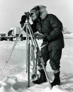
Researcher Alan Gill surveys Arctic sea ice during a 1972 expedition to study Arctic sea ice, the Arctic Ice Dynamics Joint Experiment (AIDJEX).
AIDJEX Website
Credit: NSIDC
Photographs and video of sea ice
The NSIDC Photo Gallery provides images of the Earth’s frozen places, primarily from fieldwork by NSIDC scientists.
Other possible sources for such images are:
- University Corporation for Atmospheric Research Digital Image Library
- Woods Hole Oceanographic Institution ImageSource
- NOAA Photo Library
Credit
Unless otherwise noted on or below individual images, please credit the National Snow and Ice Data Center for all image or content use.
Contact
For help with data and images on our site, please click the support button on the lower right side of this page, or call +1 303.492.6199.
If you are a journalist seeking help with images, please contact the NSIDC Press Office at +1 303.492.1497 or press@nsidc.org.

