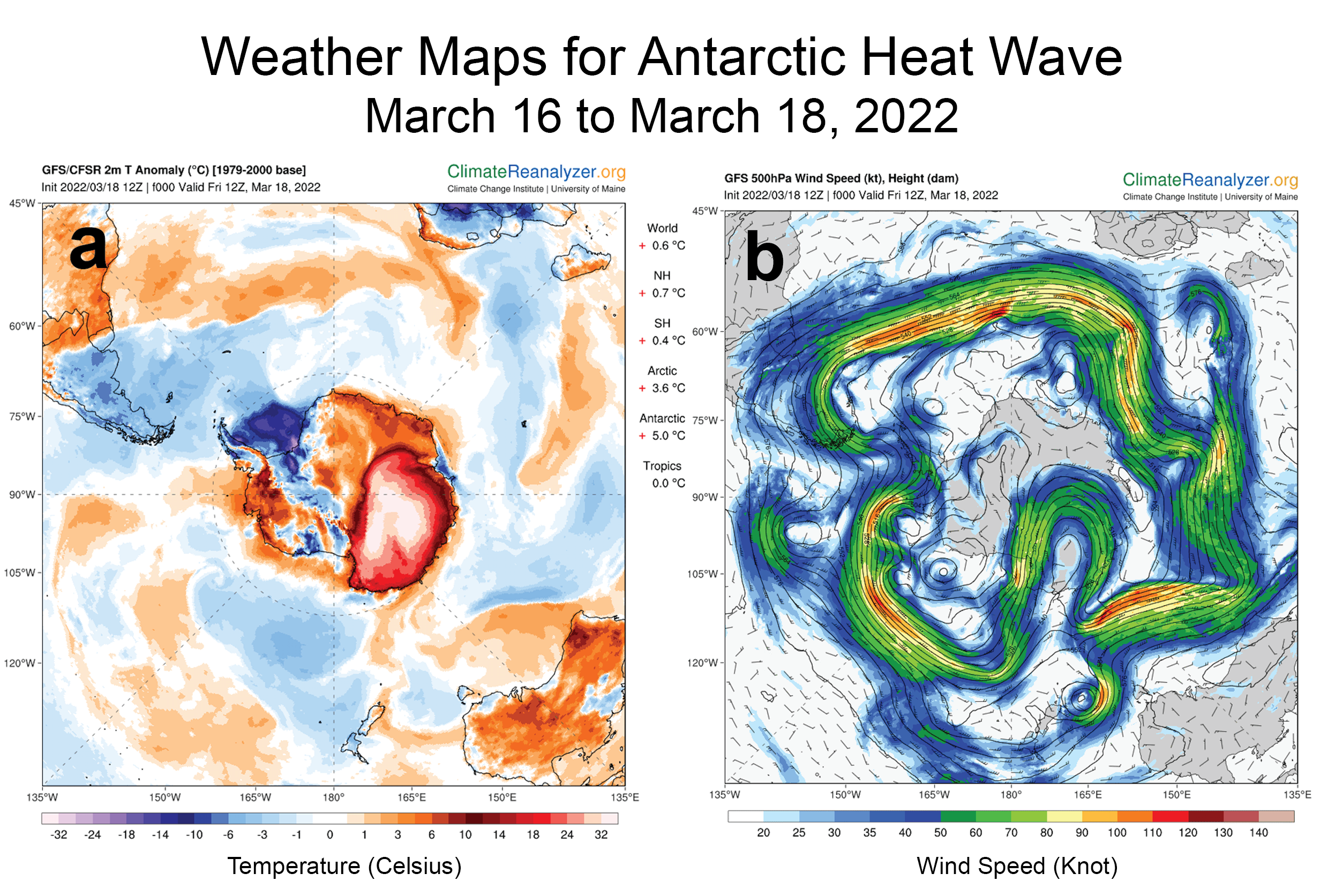
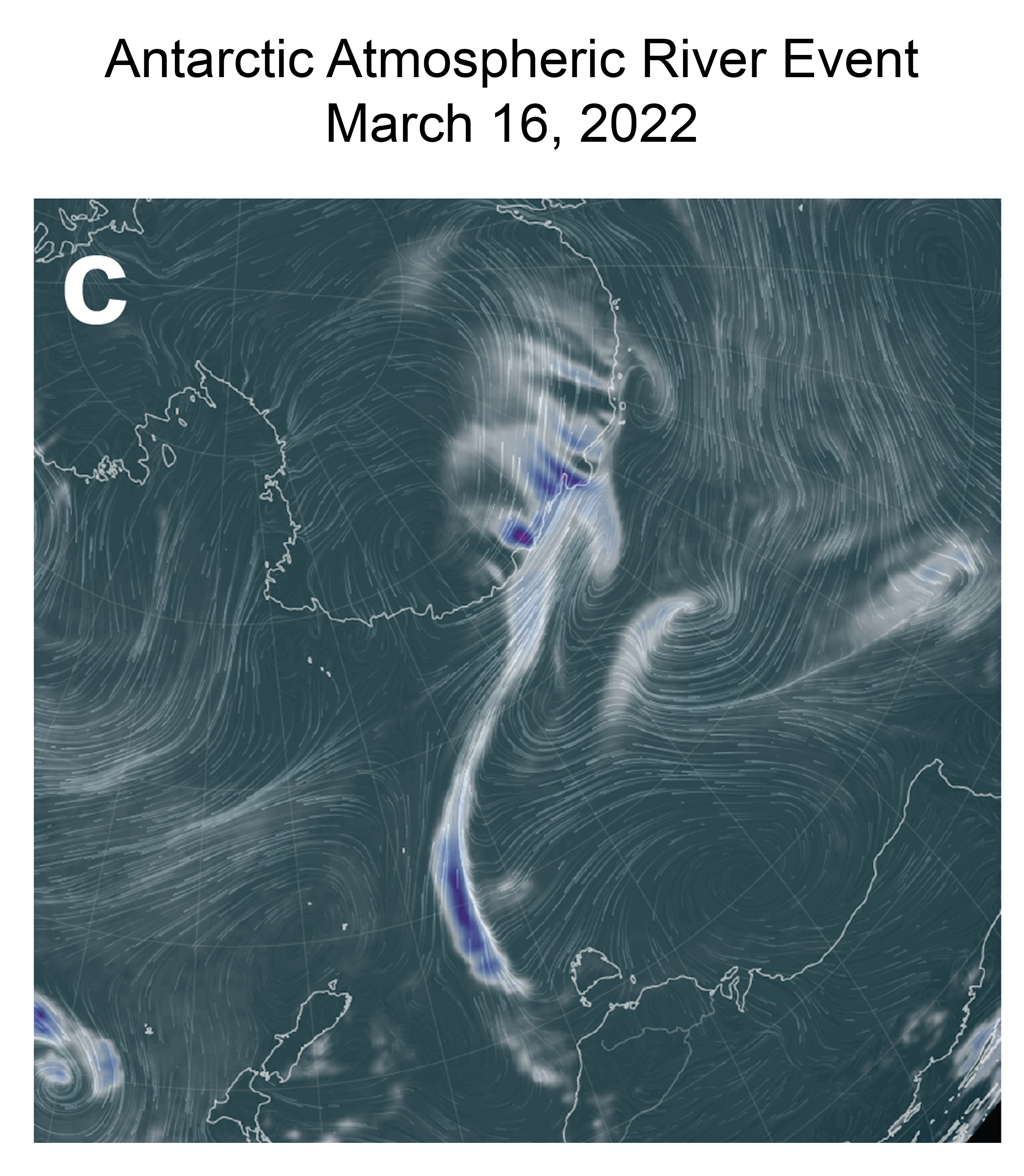
Sea ice extent near both poles was again below average, but higher than in recent years for most of the month. In the Arctic, seasonal sea ice loss began more slowly in May than in the recent years as air temperatures were closer to the 1981 to 2010 average. In the Antarctic, a slowdown in ice growth late in the month quickly brought sea ice extent levels close to record lows.
Overview of conditions
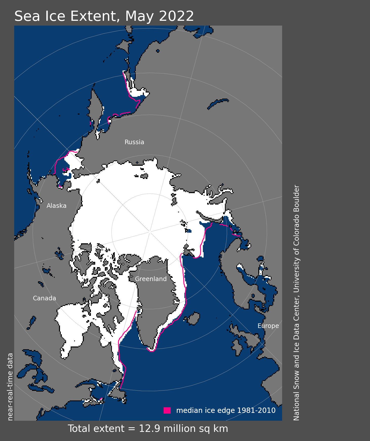
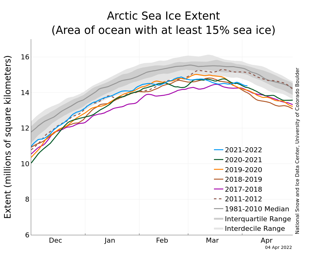
Figure 1. Arctic sea ice extent for May 2022 was 12.88 million square kilometers (4.97 million square miles). The magenta line shows the 1981 to 2010 average extent for that month. Sea Ice Index data. About the data
Credit: National Snow and Ice Data Center
High-resolution image
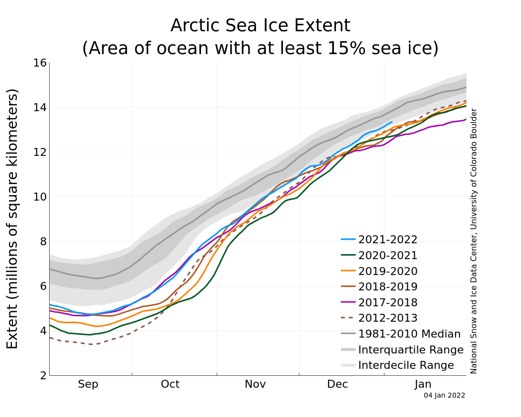
Average Arctic sea ice extent for May 2022 was 12.88 million square kilometers (4.97 million square miles) (Figure 1). This was 410,000 square kilometers (158,000 square miles) below the 1981 to 2010 average, yet it was the highest May extent since 2013. As was the case for April, sea ice extent was slow to decline, losing only 1.28 million square kilometers (494,000 square miles) during the month. Ice loss in May occurred primarily in the Bering Sea, the Barents Sea, and within Baffin Bay and Davis Strait. However, several openings, or polynyas, in the pack ice have started to form, particularly within the eastern Beaufort Sea, the Chukchi Sea, the Laptev Sea, and around Franz Joseph Land in the northern Barents Sea. Ice also started to pull back from the shores of Russia in the Kara Sea. In Hudson Bay, the ice started to melt out in the south within James Bay and off of Southampton Island in the north. Overall, the daily sea ice extent tracked within the interdecile range (encompassing 90 percent of the 1981 to 2010 daily values) for much of the month. By the end of the month, extent was close to the sea ice extent observed in late May 2012.
Conditions in context
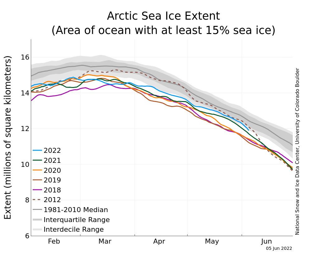
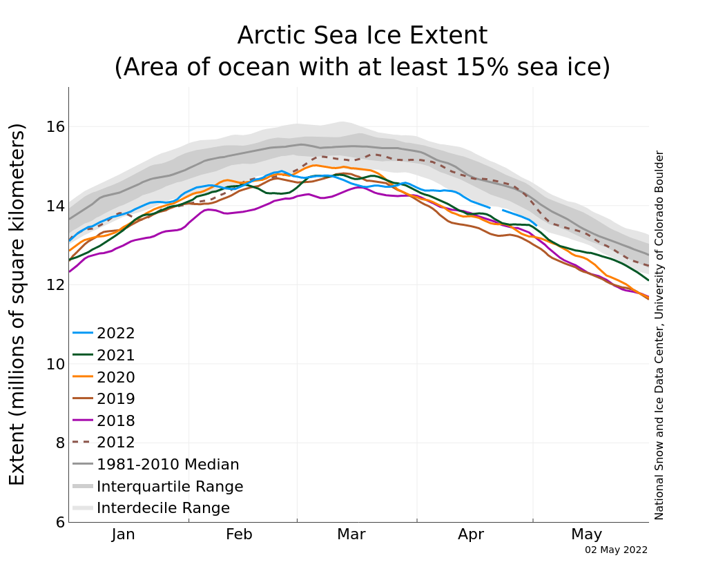
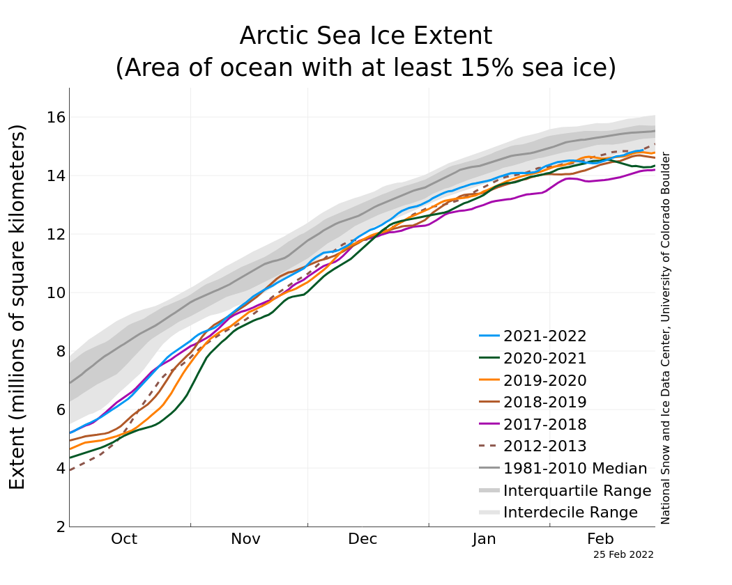
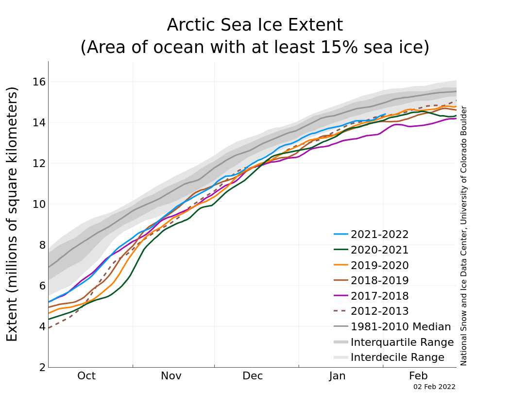
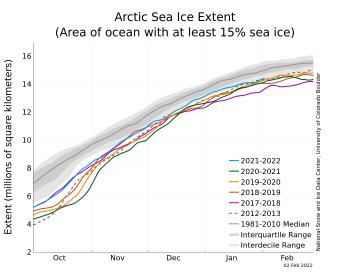
Figure 2a. The graph above shows Arctic sea ice extent as of June 5, 2022, along with daily ice extent data for four previous years and the record low year. 2022 is shown in blue, 2021 in green, 2020 in orange, 2019 in brown, 2018 in magenta, and 2012 in dashed brown. The 1981 to 2010 median is in dark gray. The gray areas around the median line show the interquartile and interdecile ranges of the data. Sea Ice Index data.
Credit: National Snow and Ice Data Center
High-resolution image
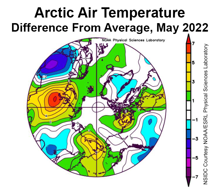
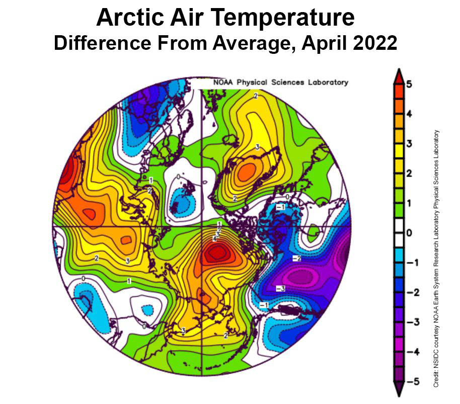
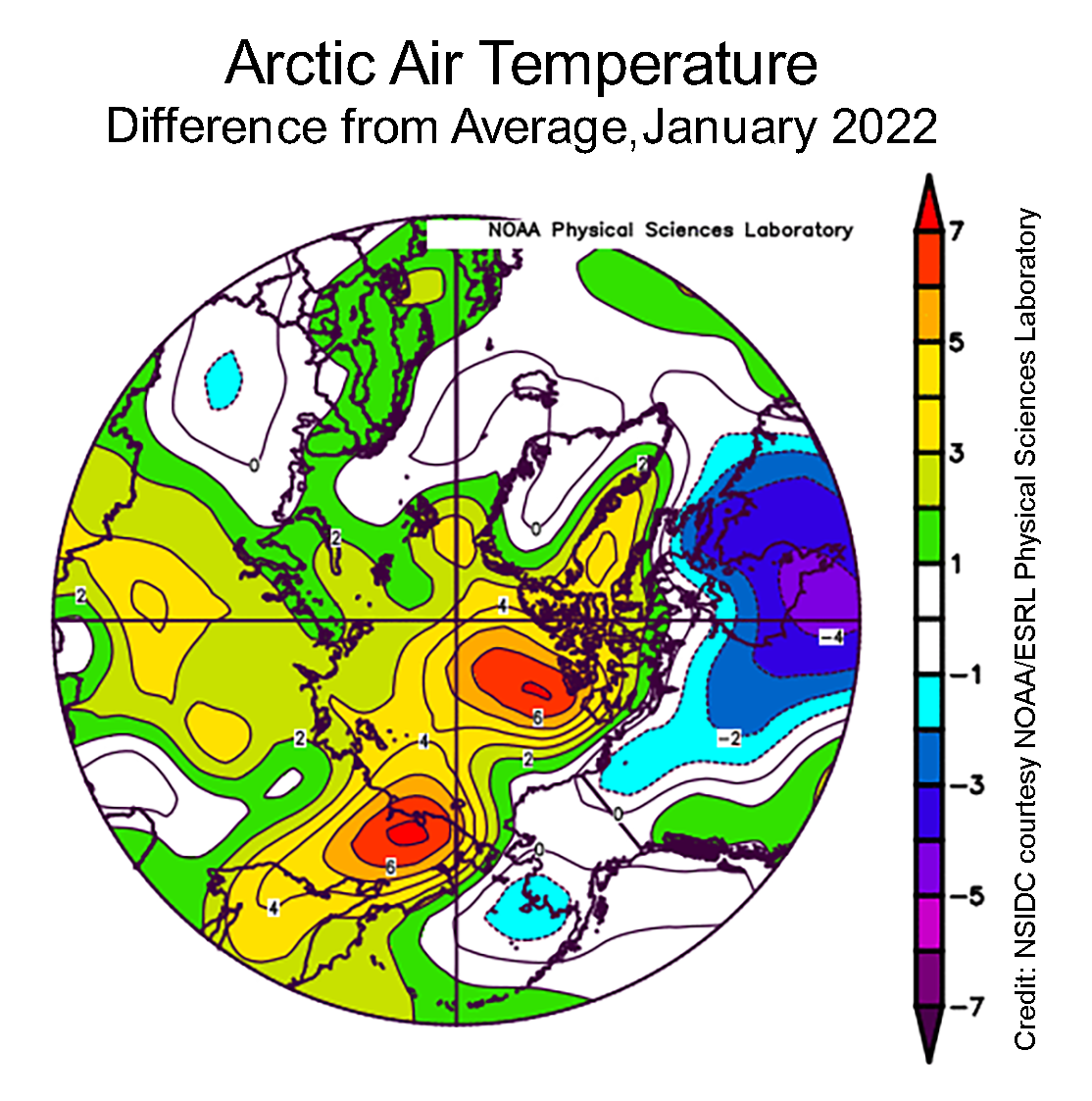
Figure 2b. This plot shows the departure from average air temperature in the Arctic at the 925 hPa level, in degrees Celsius, for May 2022. Yellows and reds indicate higher than average temperatures; blues and purples indicate lower than average temperatures.
Credit: NSIDC courtesy NOAA Earth System Research Laboratory Physical Sciences Laboratory
High-resolution image

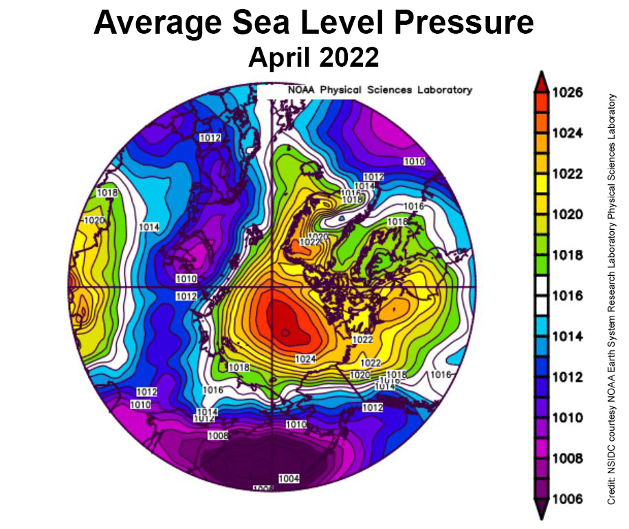
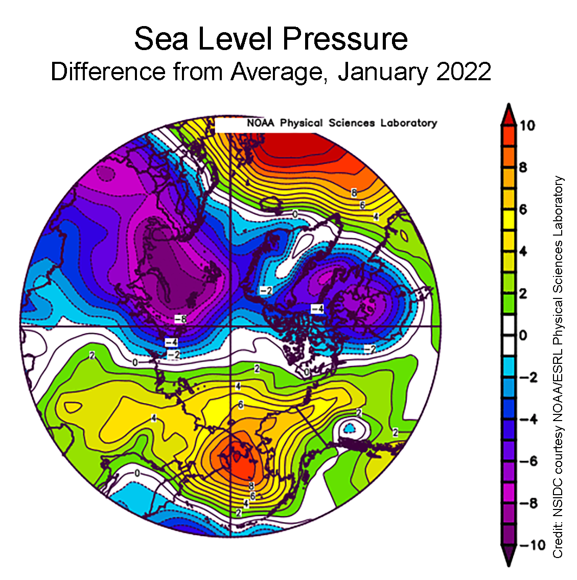
Figure 2c. This plot shows average sea level pressure in the Arctic in millibars for May 2022. Yellows and reds indicate high air pressure; blues and purples indicate low pressure.
Credit: NSIDC courtesy NOAA Earth System Research Laboratory Physical Sciences Laboratory
High-resolution image
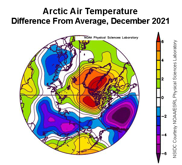
Through May, sea ice extent was tracking above levels not seen since 2013. The relatively extensive ice cover for this time of year was largely the result of lower than average temperatures in Baffin Bay. Winds from the north also slowed the retreat of ice in the Bering and Barents Seas. Within the Arctic Ocean, air temperatures at the 925 mb level (about 2,500 feet above the surface) were near average over most of the region in May, and 1 to 5 degrees Celsius (2 to 9 degrees Fahrenheit) above the 1981 to 2010 average along the coast of the Kara and East Siberian Seas, the East Greenland Sea, and the Canadian Archipelago (Figure 2b). Areas where openings formed within the ice cover were dominated by off-shore ice motion, pushing ice poleward as well as toward Fram Strait. This offshore ice motion is largely driven by a pattern of low sea level pressure over Eurasia coupled with high pressure over the Pacific sector of the Arctic (Figure 2c).
May 2022 compared to previous years
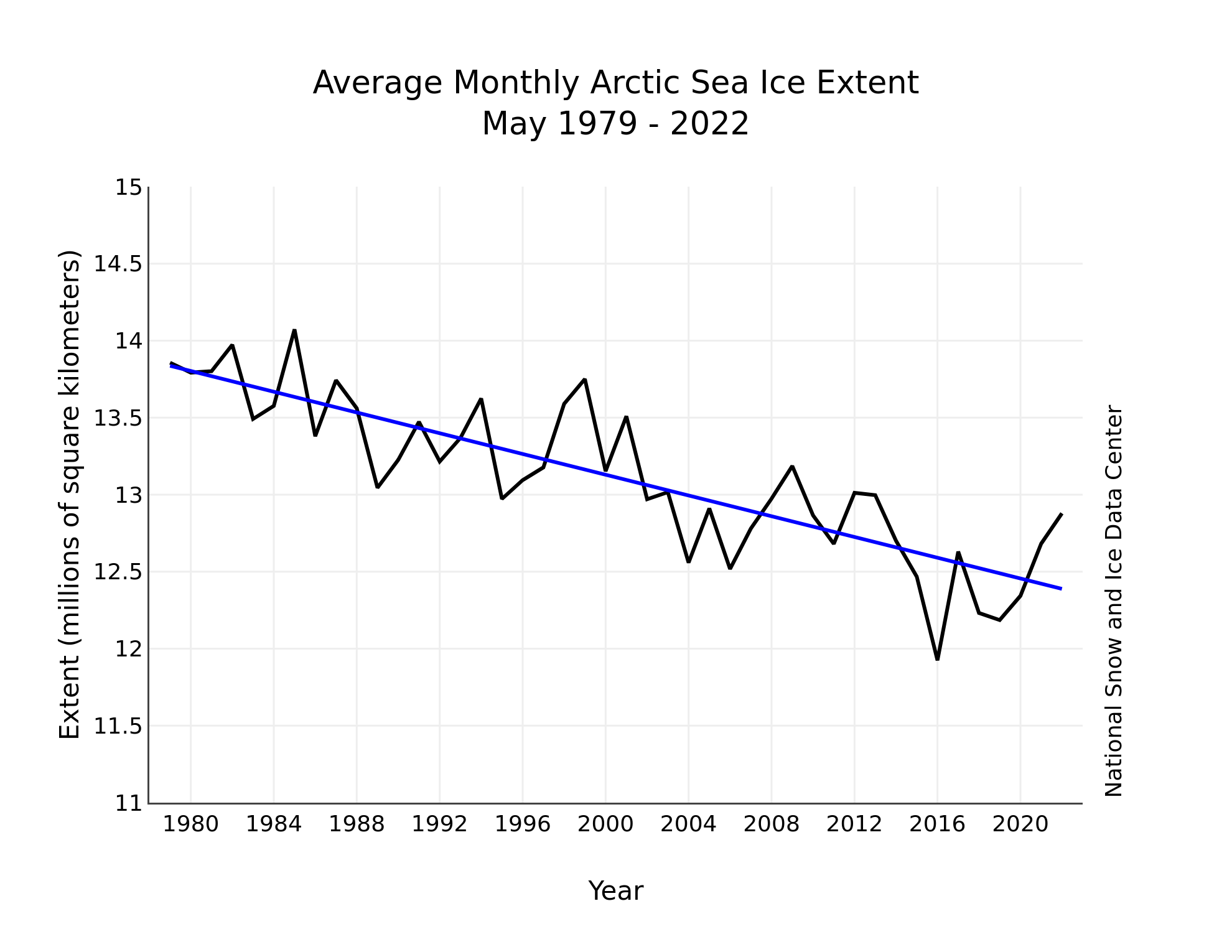
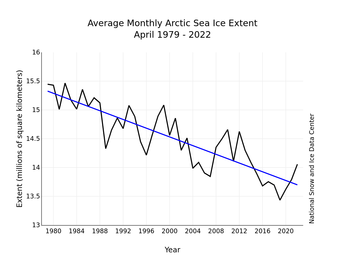
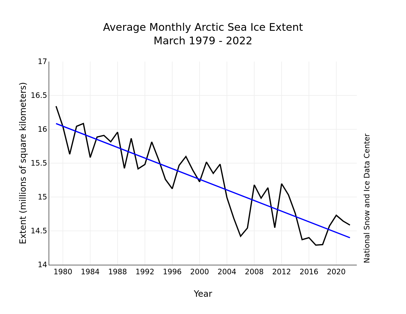
Figure 3. Monthly May ice extent for 1979 to 2022 shows a decline of 2.5 percent per decade.
Credit: National Snow and Ice Data Center
High-resolution image
May sea ice extent declined by 1.28 million square kilometers (494,000 square miles), or at a rate of 41,200 square kilometers (15,900 square miles) per day, which was slower than the 1981 to 2010 average. This resulted in an average May extent that ranked fourteenth lowest in the satellite record. The downward linear trend in May sea ice extent over the 44-year-satellite record is 33,700 square kilometers (13,000 square miles) per year, or 2.5 percent per decade relative to the 1981 to 2010 average (Figure 3). Based on the linear trend, since 1979, May has lost 450,000 square kilometers (174,000 square miles) of sea ice. This is equivalent to the size of the state of California.
Polynyas help kick-start seasonal ice loss
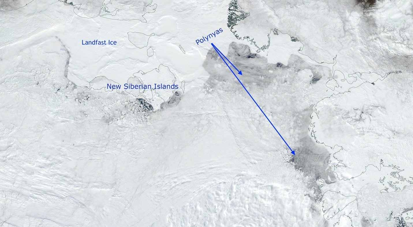
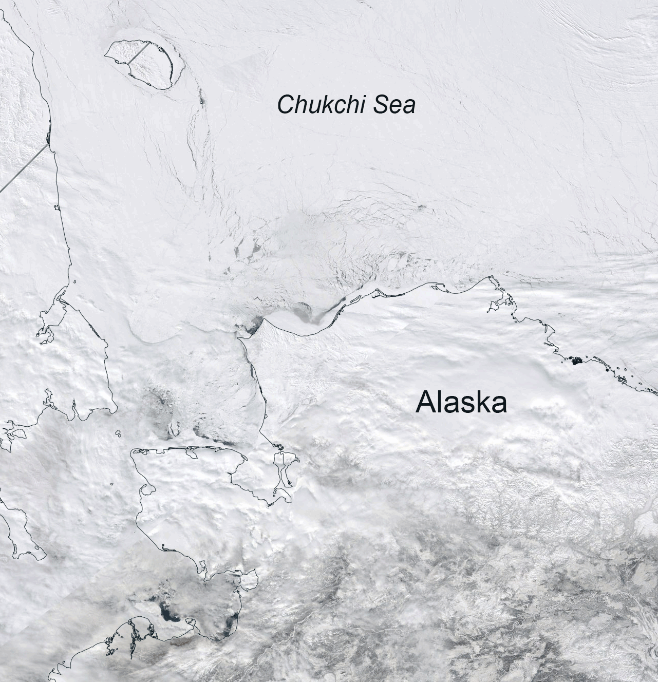
Figure 4a. This NASA Worldview image from NASA’s Moderate Resolution Imaging Spectroradiometer (MODIS) on May 29, 2022 shows polynyas forming off the coast of Siberia.
Credit: NASA
High-resolution image
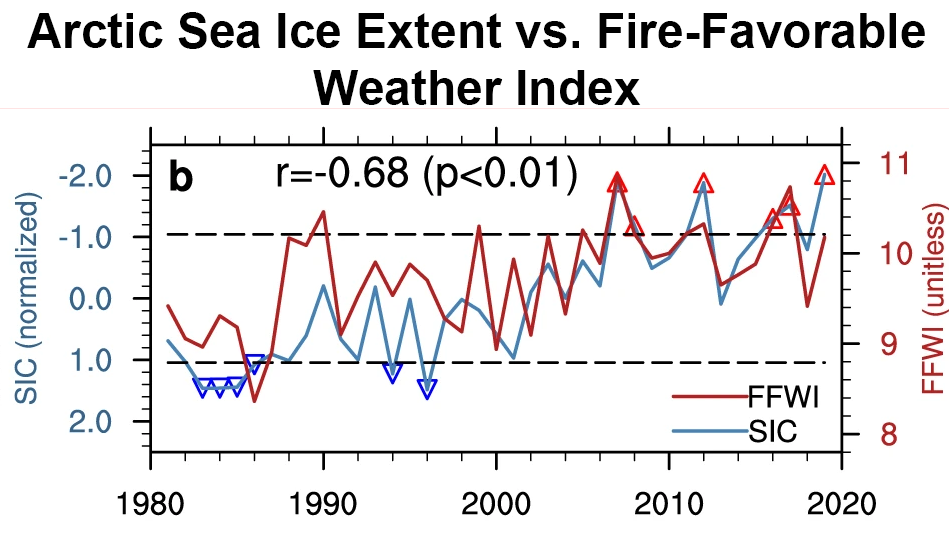
Figure 4b. This plot shows the relationship between averaged sea ice extent from July through October (in blue) and the regional average fire-favorable weather index (FFWI) over the western United States the following autumn and early winter (September to December, in red).
Credit: Zou et al., 2021
High-resolution image
Polynyas have begun to form, providing open water regions that strongly absorb the sun’s energy, warming the near-surface ocean mixed layer, and enhancing lateral ice melt from the sides. One of the larger polynyas is in the Laptev Sea to the west of the New Siberian Islands (Figure 4a). Despite the thin cloud cover, polynyas can be seen at the edge of the landfast ice, ice fastened to the coastline, to the west of the New Siberian Islands as well off the coast of the Taymyr Peninsula between the Kara and Laptev Seas.
A consequence of summer sea ice loss is that the ocean absorbs more of the sun’s energy. Before the ice can form again in the fall and winter, this heat has to be released back to the atmosphere. This is one of the reasons why the Arctic is warming more strongly than the global average, particularly in the fall season. Studies have suggested this amplified Arctic warming may be impacting weather systems at lower latitudes. One hypothesis is that the warm air released from the surface propagates up through the atmosphere and disrupts the polar vortex in the stratosphere. This can lead to cold air outbreaks, such as in February 2021 when cold Arctic air reached as far south as Texas, causing the failure of the power grid, billions of dollars in damage, and loss of lives. Proposed links between Arctic warming and mid-latitude weather nevertheless remain controversial and are far from settled.
Another recent study reveals a correlation between Arctic sea ice extent (averaged from July to October) and conditions favoring California wildfires after removing the long-term trend in both the sea ice and a regional fire-favorable weather conditions index. However, correlation is not causation. This study addresses the potential physical link by examining sensitivity simulations using low and high sea ice years and comparing the atmospheric conditions from climate model runs. The results suggest that during low sea ice minimum years there is tendency for low sea level air pressure over Alaska and high sea level pressure over the western United States. This results in dry and hot air flowing from the south and southwest over California, conditions favorable for wildfires there in the following autumn and early winter (Figure 4b).
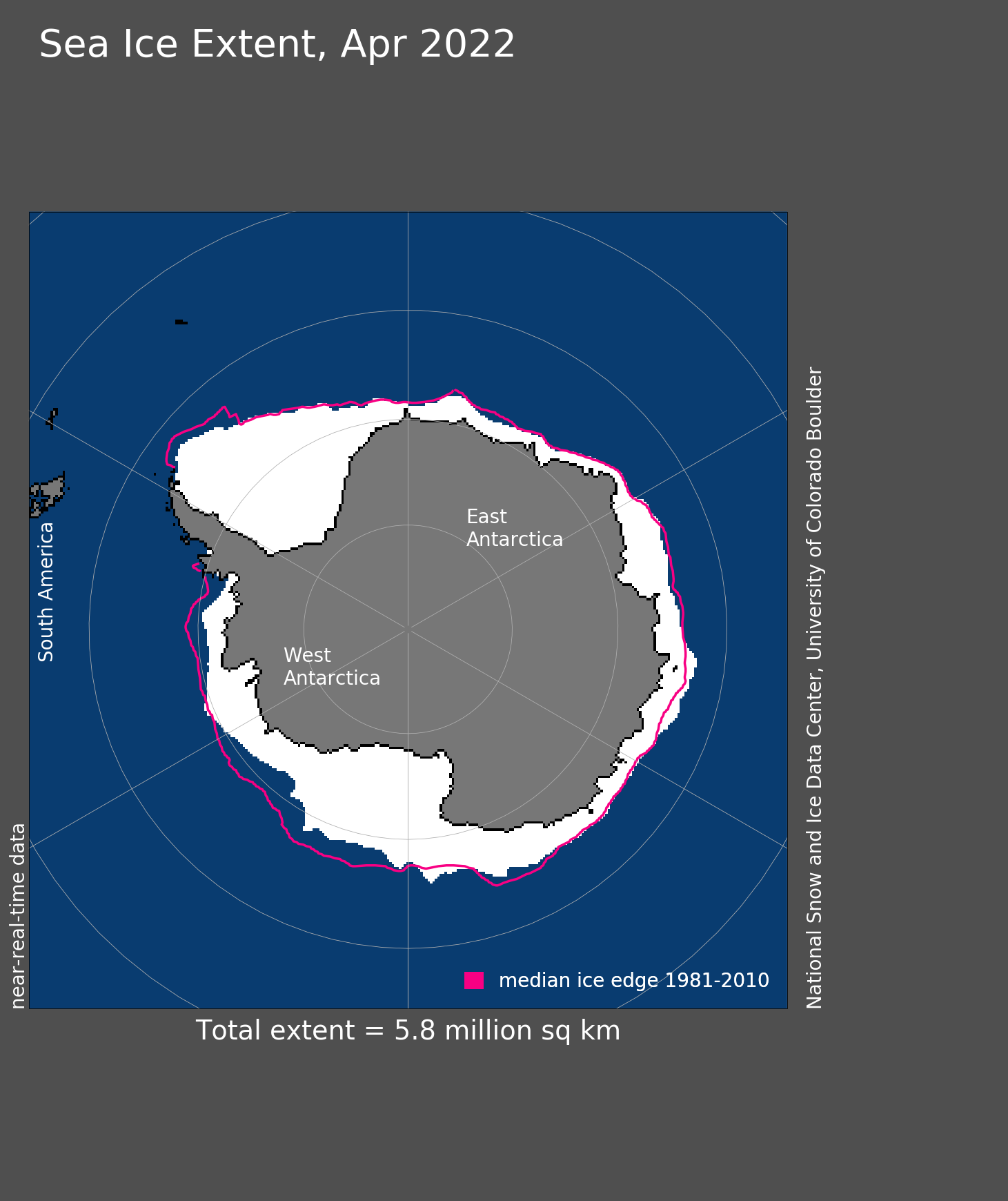
Mapping volume of ice and snow over Antarctic sea ice proves difficult
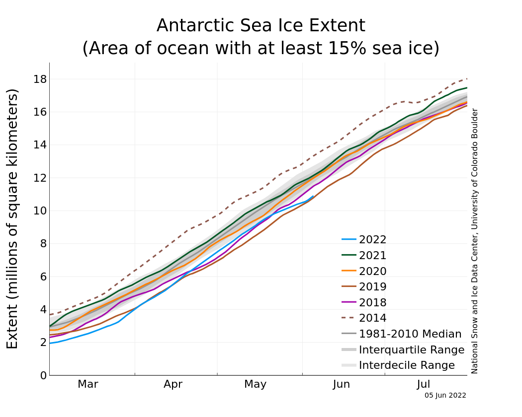
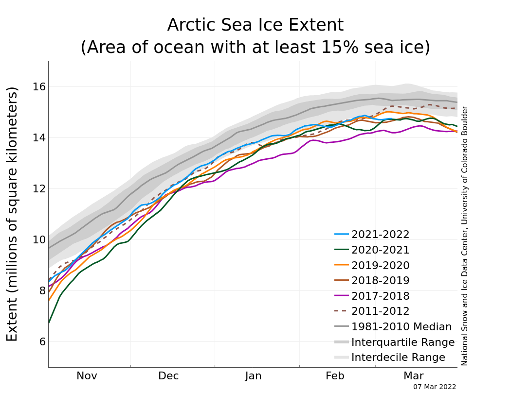
Figure 5a. The graph above shows Antarctic sea ice extent as of June 5, 2022, along with daily ice extent data for four previous years and the record high year. 2022 is shown in blue, 2021 in green, 2020 in orange, 2019 in brown, 2018 in magenta, and 2014 in dashed brown. The 1981 to 2010 median is in dark gray. The gray areas around the median line show the interquartile and interdecile ranges of the data. Sea Ice Index data.
Credit: National Snow and Ice Data Center
High-resolution image

Figure 5b. This image shows dual frequency Ku- and Ka-band radar (KuKa) deployed over Antarctic pancake sea ice.
Credit: Povl Abrahamsen
High-resolution image
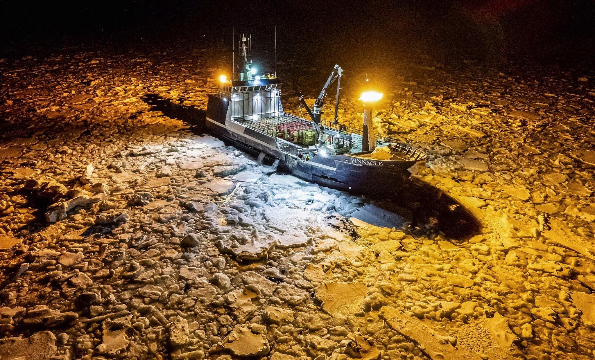
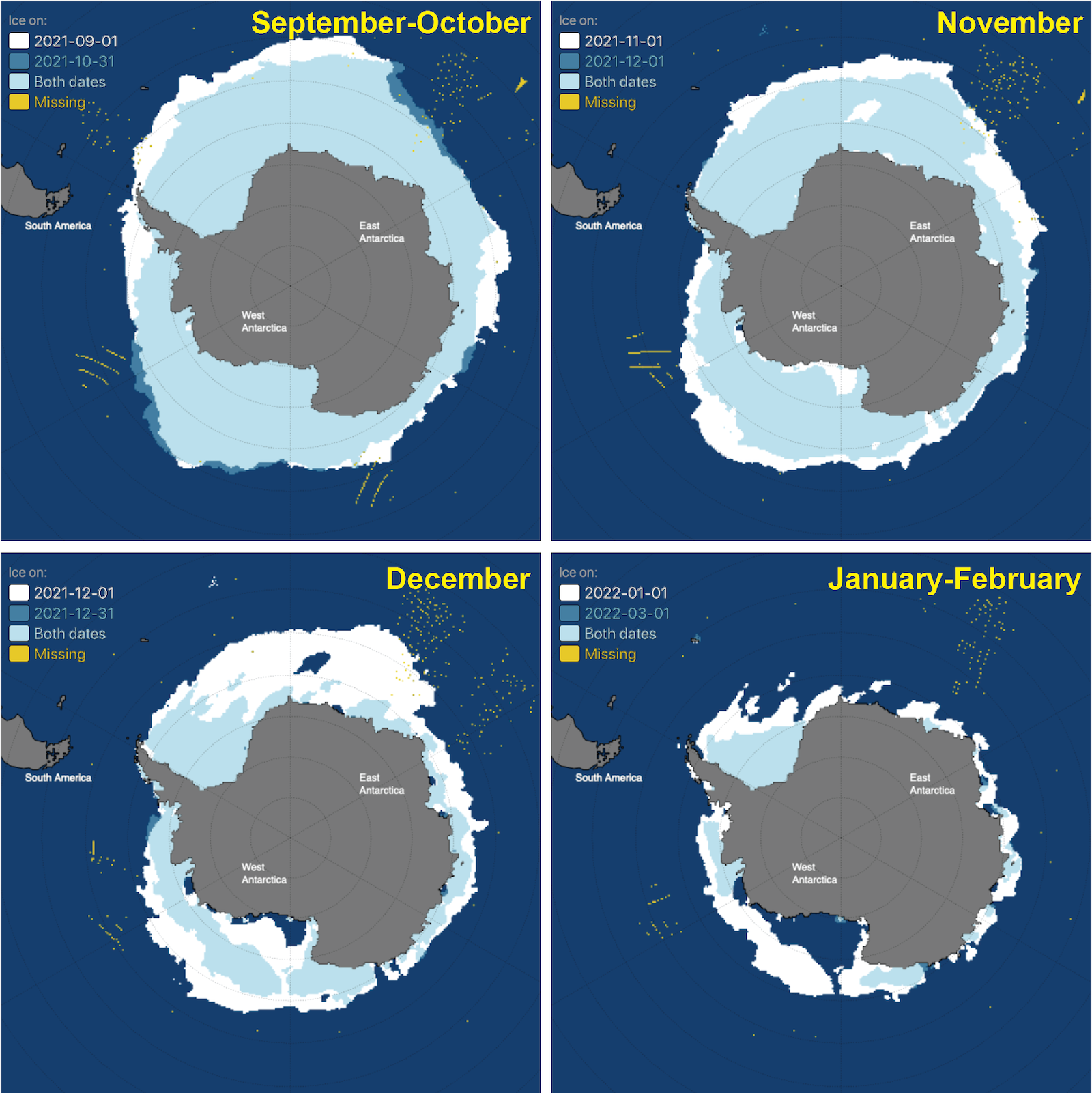
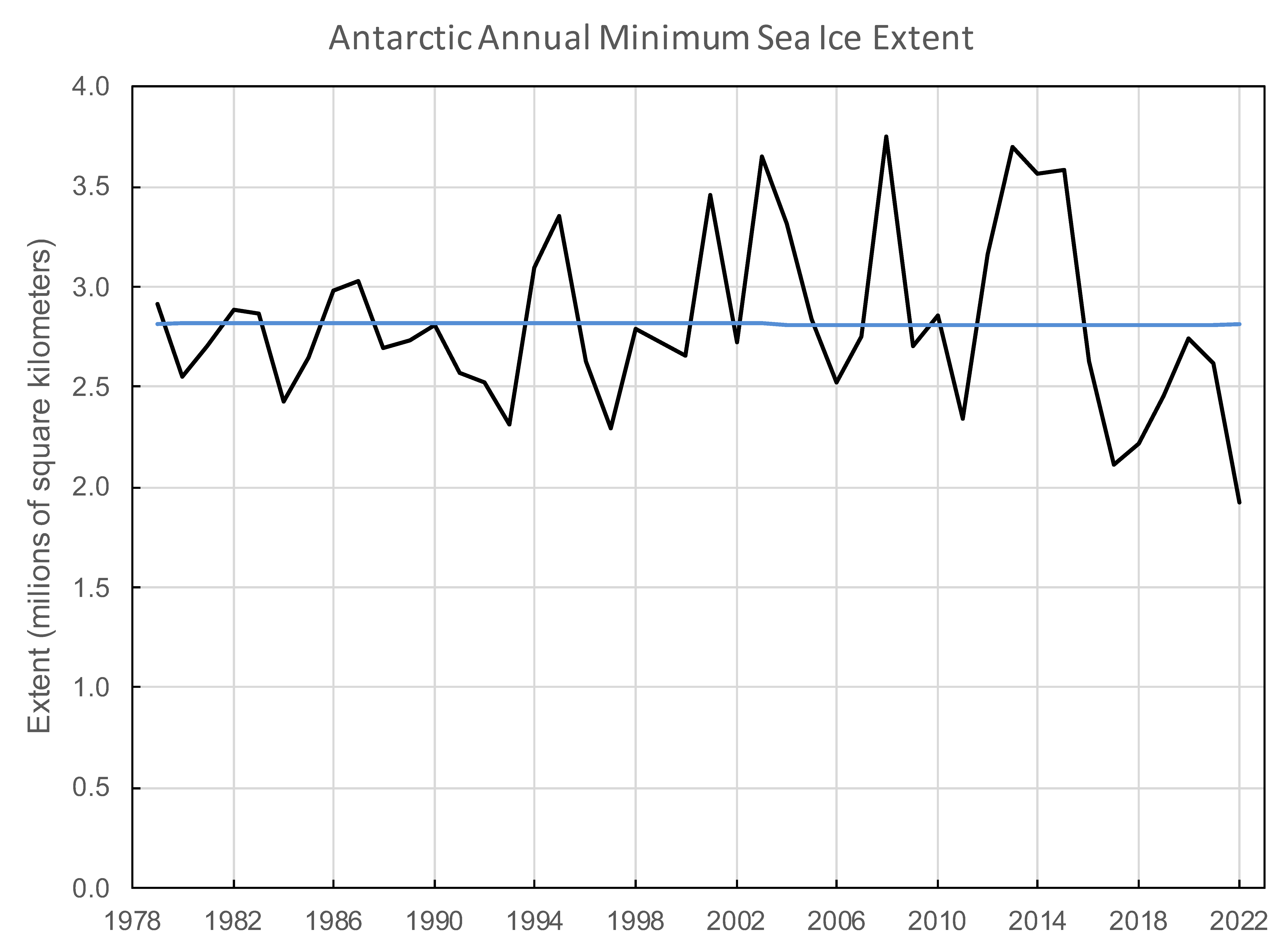
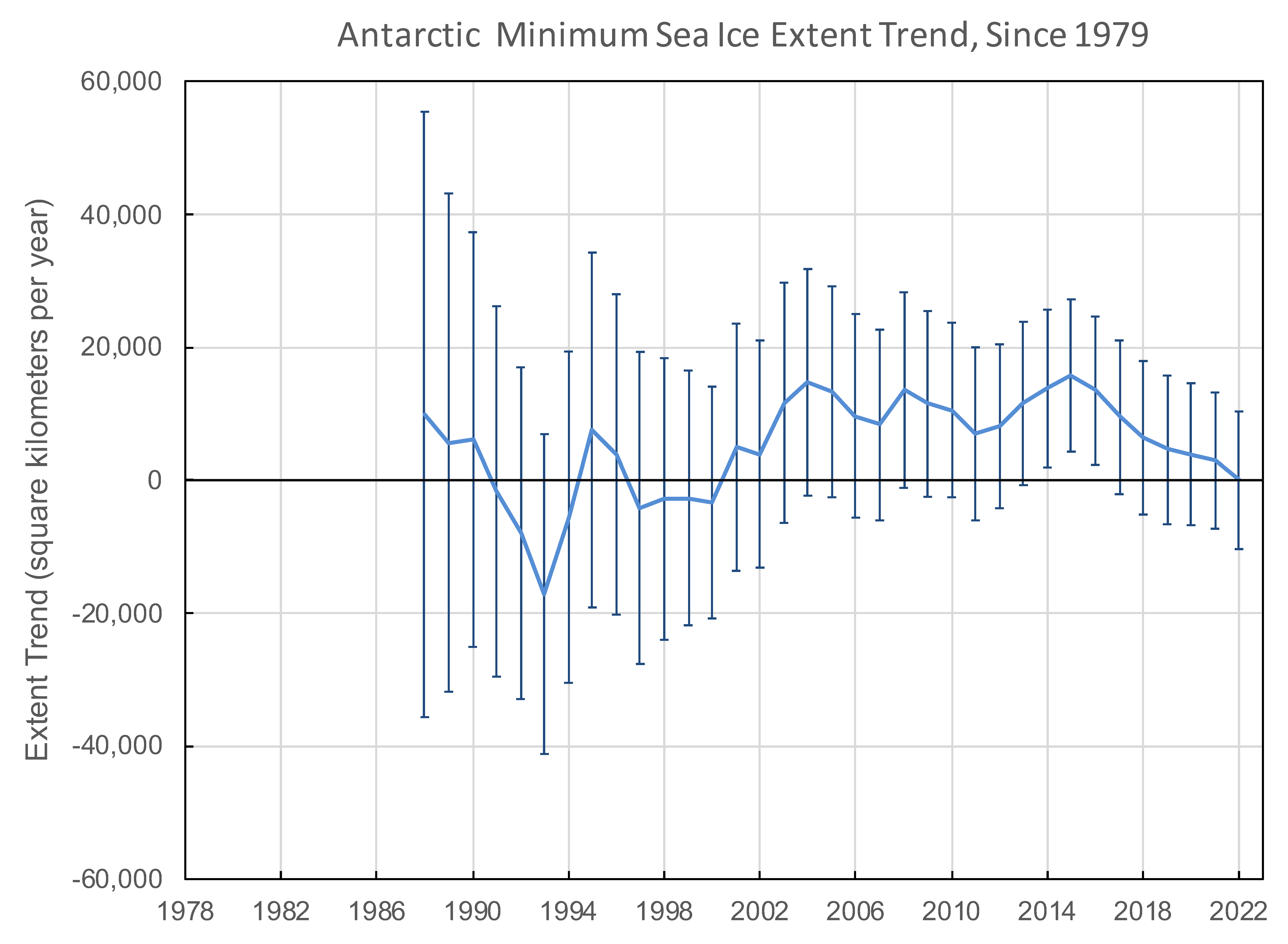
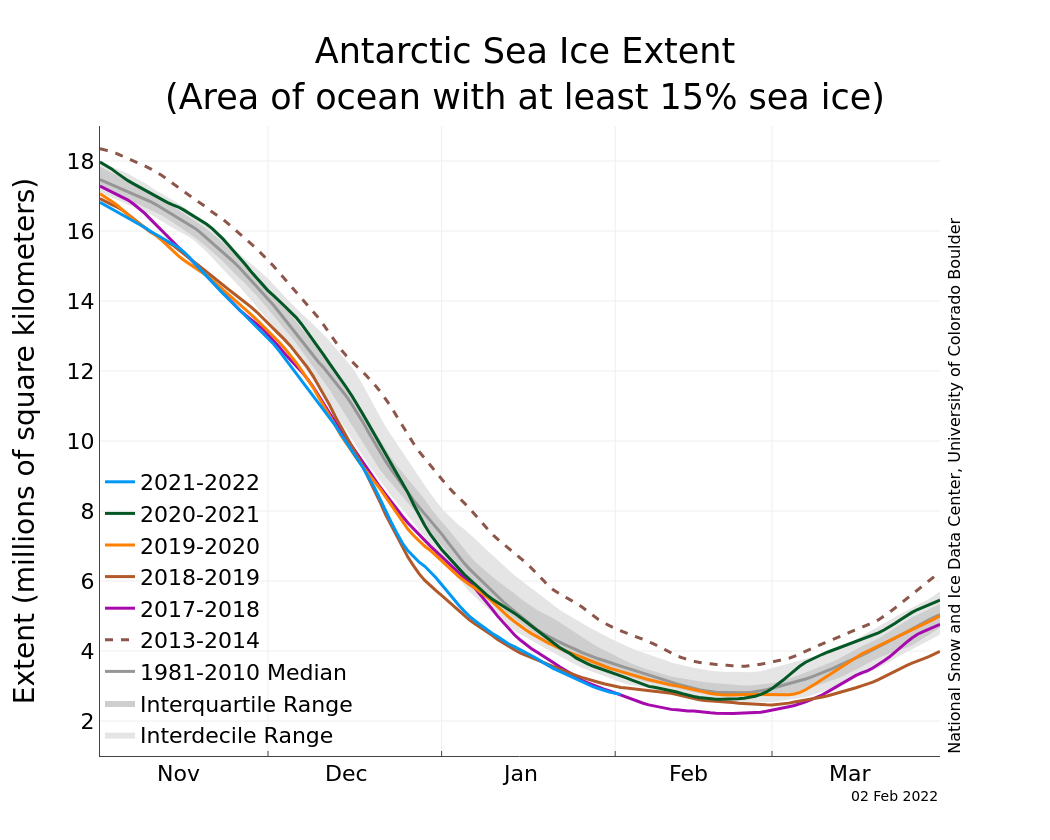
As reported in a previous post, this year, Antarctic sea ice shrank to the lowest extent in the satellite record at 1.92 million square kilometers (741,000 square miles) on February 25. This event was set against the background of several low minimum extents since 2014. During the month of May, sea ice tracked slightly below the 1981 to 2010 reference period, until late in the month when sea ice autumn growth slowed significantly (Figure 5a). Stronger than average winds from the north and northeast in the Belligshausen and Amundsen Sea regions led to warm conditions near the sea ice edge, inhibiting growth. At month’s end, Antarctic sea ice extent was above only 1980, 1986, 2017, and 2019 in the 44-year record. Sea ice is particularly low in the Amundsen and Weddell Seas.
Reliable information on Antarctic sea ice thickness, important for gaining a fuller understanding of the Antarctic sea ice system, remains elusive. In the Arctic, sea ice thickness can be more accurately estimated using satellite altimeters. However, studies suggest that satellite altimeters may be over-estimating ice thickness compared to ship-based observations. This may be because of the way snow cover on the ice affects the measurements. There are still large uncertainties in the Antarctic snow and sea ice thickness, and hence the overall sea ice volume.
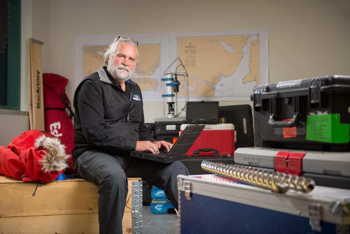
A United Kingdom-led project, called Drivers and Effects of Fluctuations in sea Ice in the ANTarctic (DEFIANT), aims to address this problem. The DEFIANT team is particularly interested in learning how radar waves interact with the snow that covers Antarctic sea ice. A recent DEFIANT field campaign involved three scientists travelling to the Weddell Sea with a radar designed to mimic those mounted on satellites. They investigated radar penetration into snow of different ages, densities, and surface roughness (Figure 5b). The results will help the research community better understand how to measure the underlying sea ice thickness using satellites. In 2023, two DEFIANT-affiliated scientists will spend the entire winter in Antarctica with the same radar instrument, monitoring the snow cover and its radar-reflective properties.
References
Zou, Y., P. J. Rasch, H. Wang, et al. 2021. Increasing large wildfires over the western United States linked to diminishing sea ice in the Arctic. Nature Communications. doi:10.1038/s41467-021-26232-9


