Overview of conditions
Arctic sea ice extent declined at a fairly rapid rate through the first three weeks of July, but the loss rate then slowed due to a shift in weather patterns. In Antarctica, the advance of sea ice nearly halted for about a week in early July, and then resumed. At the end of the month, Antarctic extent was at or near a record high for this time of year.
Overview of conditions
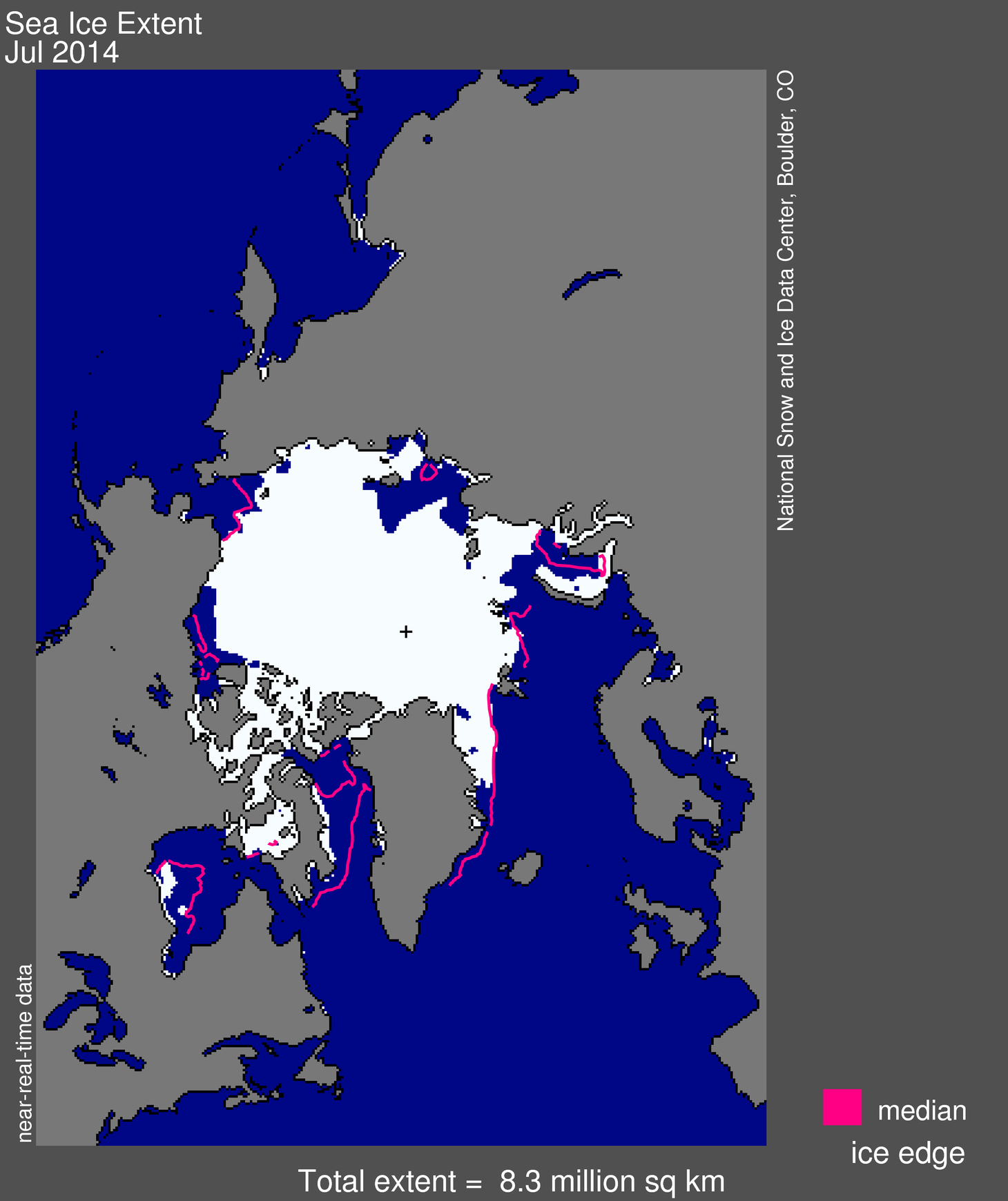
Figure 1. Arctic sea ice extent for July 2014 was 8.25 million square kilometers (3.19 million square miles). The magenta line shows the 1981 to 2010 median extent for that month. The black cross indicates the geographic North Pole. Sea Ice Index data. About the data
Credit: National Snow and Ice Data Center
High-resolution image
July 2014 average ice extent was 8.25 million square kilometers (3.19 million square miles). This is 1.85 million square kilometers (714,000 square miles) below the 1981 to 2010 average for the month.
Ice extent is below average in nearly all sectors of the Arctic. Open water continued to grow in the Laptev and Beaufort Seas, reaching well north of 80oN in the Laptev Sea. By the end of the month, the Alaskan Coast was essentially free of ice except for small patches of very diffuse ice off Barrow. The Barents Sea, Hudson Bay, and Baffin Bay/Davis Strait are now essentially ice free. Large areas of low concentration ice in the central Beaufort Sea are likely to melt out in coming weeks. The Northwest Passage through the channels of the Canadian Arctic Archipelago remains choked with ice. Parts of the Northern Sea Route are still difficult to traverse because of high-concentration, near-shore ice between the Laptev and East Siberian seas and also north of the Taymyr Peninsula.
Conditions in context

Figure 2. The graph above shows Arctic sea ice extent as of August 4, 2014, along with daily ice extent data for four previous years. 2014 is shown in blue, 2013 in green, 2012 in orange, 2011 in brown, and 2010 in purple. The 1981 to 2010 average is in dark gray. Sea Ice Index data.
Credit: National Snow and Ice Data Center
High-resolution image
For July 2014 as a whole, ice extent declined at an average rate of 86,900 square kilometers (33,600 square miles) per day, close to the 1981 to 2010 average July rate of 86,500 square kilometers (33,400 square miles) per day. However, this averages together a fairly fast rate of decline over the first three weeks of the month with a slower rate of decline over the remainder of the month.
The slower ice loss later in the month reflects a shift in weather patterns. For much of the month, high pressure at sea level dominated the central Arctic Ocean and the Barents Sea. However, this pattern broke down and was replaced by lower-than-average pressure over the central Arctic Ocean. A low pressure pattern tends to bring cool conditions and the counterclockwise winds associated with this pattern also tend to spread the ice out.
July 2014 compared to previous years

Figure 3. Monthly July ice extent for 1979 to 2014 shows a decline of 7.4% per decade relative to the 1981 to 2010 average.
Credit: National Snow and Ice Data Center
High-resolution image
July 2014 is the 4th lowest Arctic sea ice extent in the satellite record, 340,000 square kilometers (131,000 square miles) above the previous record lows in July 2011, 2012, and 2007. The monthly linear rate of decline for July is 7.4% per decade.
More news on the Antarctic
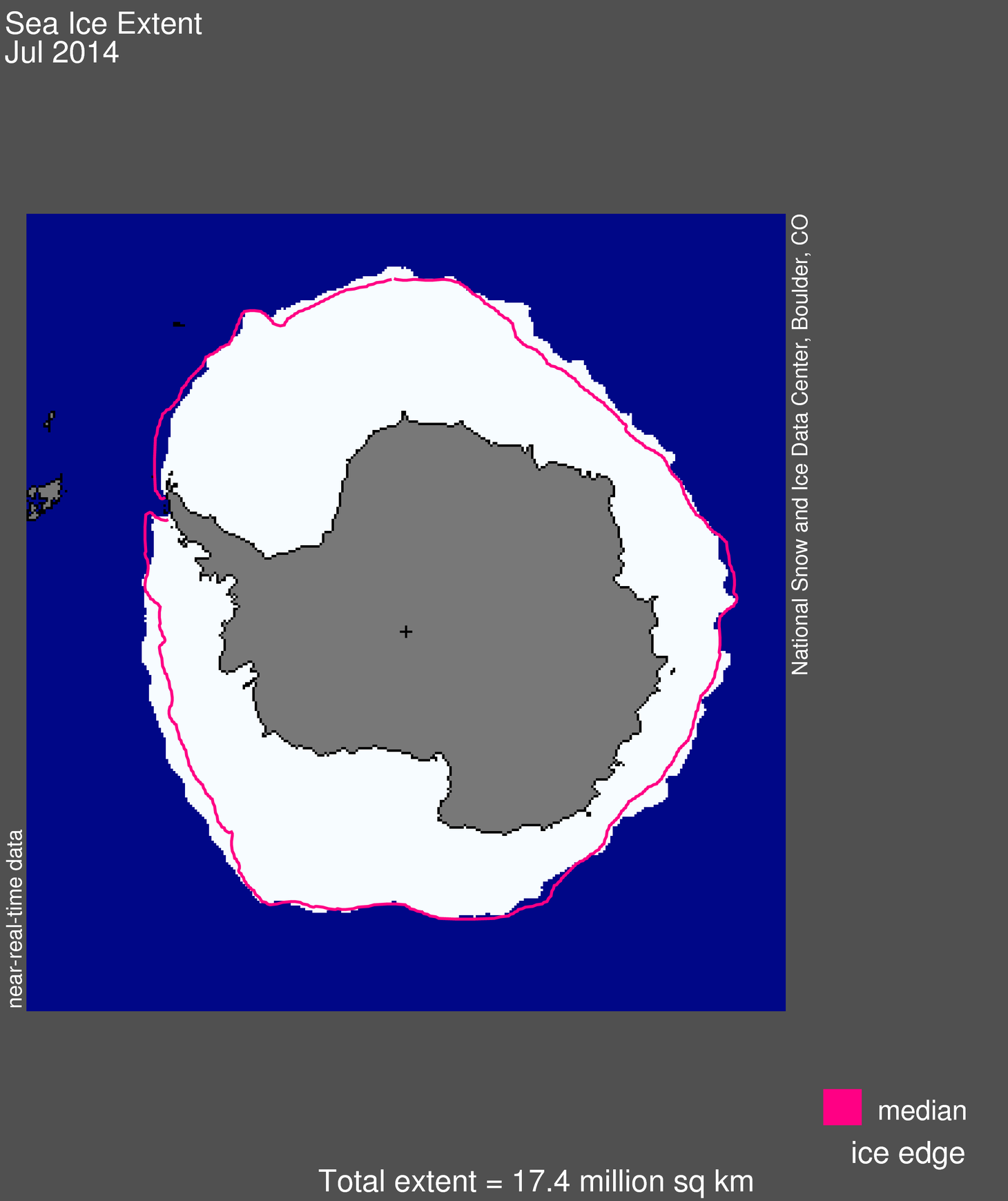
Figure 4a. Antarctic sea ice extent for July 2014 was 17.40 million square kilometers (6.72 million square miles). The magenta line shows the 1981 to 2010 median extent for that month. The black cross indicates the geographic South Pole. Sea Ice Index data. About the data
Credit: National Snow and Ice Data Center
High-resolution image
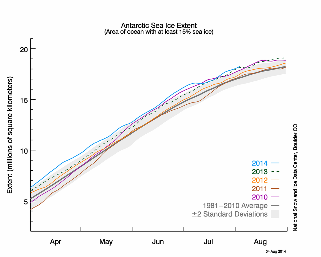
Figure 4b. The graph above shows Antarctic sea ice extent as of August 4, 2014, along with daily ice extent data for four previous years. 2014 is shown in blue, 2013 in green, 2012 in orange, 2011 in brown, and 2010 in purple. The 1981 to 2010 average is in dark gray. Sea Ice Index data.
Credit: National Snow and Ice Data Center
High-resolution image
In our previous post, we noted that on July 1, Antarctic sea ice extent was growing rapidly, and could surpass the September 2013 record high extent (over the period of satellite observations). During early July, the advance of Antarctic sea ice extent nearly halted, but toward the end of the month, there was another period of rapid ice growth. Maximum extent is usually reached in September or October, at the end of the austral winter.
Many readers may be familiar with NSIDC’s Charctic interactive sea ice graph that allows one to plot daily Arctic ice extent for any year in the satellite record (1979 to present) and make quick comparisons with average conditions and between different years. NSIDC has recently added an Antarctic option to Charctic. We have done so in response to growing interest in Antarctic sea ice conditions and the very different behavior of Arctic and Antarctic sea ice. Just go to the Charctic site and click the button marked “Antarctic.”
Questions about data processing
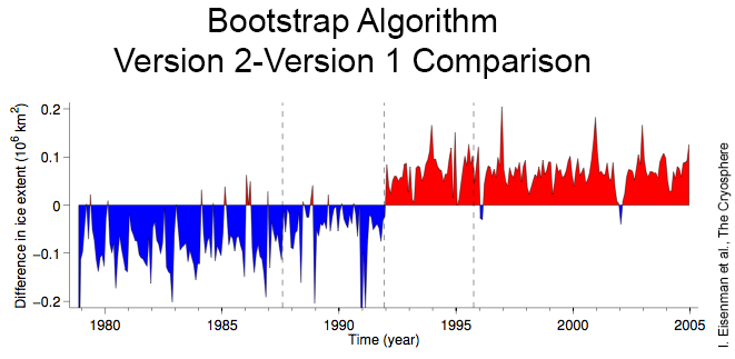
Figure 5. This graph shows the differences in Antarctic sea ice extent between Version 2 and Version 1 of the Bootstrap algorithm. Blue indicates when Version 2 derived values were lower than Version 1; red indicates when Version 2 derived values were higher than Version 1. The vertical dashed lines indicate satellite sensor changes.
Credit: I. Eisenman et al., The Cryosphere
High-resolution image
A recent paper investigated the processing of Antarctic sea ice data and how this affects the interpretation of Antarctic ice extent trends. While their findings do not affect NSIDC’s analysis of Antarctic sea ice extent, as we use a different data set, it is an interesting example of scientific rigor regarding data, and it does affect other reports of Antarctic sea ice trends.
The paper studied the Bootstrap algorithm, which has been used in several published reports of Antarctic trends, including the last two IPCC Assessment Reports. These reports suggested that the Antarctic sea ice extent shifted from a small, statistically insignificant upward trend in the early 2000s to a more substantial, and statistically significant upward trend in recent years. (NSIDC uses a different algorithm, called NASA Team, to estimate sea ice extent.)
The paper found that following an update to the algorithm in 2007, using the newer Version 2 of the Bootstrap algorithm produced Antarctic sea ice extent trends that were approximately two times larger than those derived using Version 1. Closer examination of the data showed a noticeable step change in extent at the point of transition to a new satellite sensor in 1991. This step change appeared to be related to an error in calibration between the sensors, rather than actually being an abrupt shift in Antarctic sea ice.
Trends derived from both versions for time periods either before or after the sensor transition are similar. However, the two algorithms produce different results when trends that span the 1991 sensor transition are calculated. Using Version 2 of the algorithm produces a markedly higher trend.
Using the newer version of the algorithm, Antarctic extent trends agree much more closely with the trends from the NASA Team algorithm used by NSIDC. Regardless, the expansion in Antarctic sea ice is confirmed by other groups using different techniques.
References
Eisenman, I., W. N. Meier, and R. J. Norris. 2014. A spurious jump in the satellite record: has Antarctic sea ice expansion been overestimated?, The Cryosphere 8, 1289-1296, doi:10.5194/tc-8-1289-2014.

