By Laura Naranjo
Although most NASA missions probe the mysterious environments of outer space, Earth’s own environments hold plenty of mysteries. As a result, NASA initiated the Earth Observing System (EOS), a robust network of satellites designed to capture long-term observations of Earth. The first mission launched in 1999 and additional missions have launched nearly every year, monitoring Earth’s atmosphere, biosphere, land surfaces, poles, and oceans.
NASA sought institutions to host data from these missions and become a Distributed Active Archive Center (DAAC), which would archive and distribute massive amounts of data, making them freely available. Each of these centers would serve one or more specific Earth science disciplines and work closely with science communities.
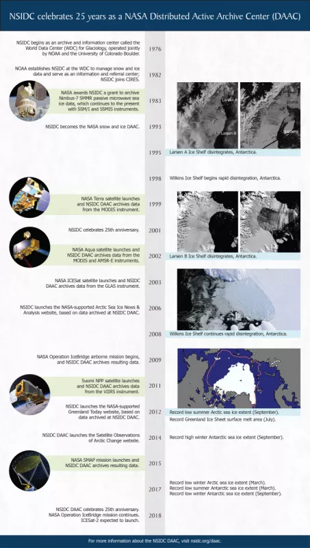
NSIDC already had a strong track record managing data for the National Oceanic and Atmospheric Administration (NOAA), and in 1993, NASA contracted NSIDC to be the snow and ice DAAC. The NSIDC DAAC was tasked to archive and distribute NASA cryospheric mission data, and also compile documentation and develop tools to help researchers understand, download, and use the data products.
For example, in 1999, the NASA Terra satellite launched, deploying the first EOS mission instrument designed to monitor ice and snow: the Moderate Resolution Imaging Spectroradiometer (MODIS). NSIDC DAAC began ingesting and providing access to these data, distributing 29,173 files, or 0.03 terabytes, to researchers in 1999.
NSIDC DAAC also archives and distributes data from several subsequent missions. In 2002, the NASA Aqua satellite launched, with the Advanced Microwave Scanning Radiometer for EOS (AMSR-E) sensor and an additional MODIS instrument aboard. The Ice, Cloud, and land Elevation Satellite (ICESat) followed in 2003, with the Geoscience Laser Altimeter System (GLAS) instrument aboard, and the Operation Icebridge Mission began airborne campaigns in 2009 to span the gap before ICESat-2 launches. A MODIS follow-on mission, the Visible Infrared Imaging Radiometer Suite (VIIRS), launched in 2011, and the Soil Moisture Active Passive (SMAP) mission launched in 2015.
As missions launched and related field campaigns concluded, NSIDC DAAC data holdings grew, as did our file distribution and user community. In 2017, we distributed 144,034,659 data files to users, totaling more than 416 terabytes.
Based on some of the NASA EOS data it archives, the NSIDC DAAC developed the Satellite Observations of Arctic Change website, which maps changing conditions throughout the Arctic. NASA also supported two other websites based on NASA EOS cryosphere data: Arctic Sea Ice News & Analysis, which tracks polar sea ice extent and trends, and Greenland Today, which monitors surface melt on the Greenland Ice Sheet.
Today, the NSIDC DAAC provides data and information on snow, sea ice, glaciers, ice sheets, ice shelves, frozen ground, soil moisture, and climate interactions, in support of research in global change detection, model validation, and water resource management. We continue to provide free access to historic and current NASA EOS missions as part of our data holdings, and actively plan support for future NASA missions. In conjunction with the eleven other DAACs, the data and services that we provide is helping researchers around the globe unlock the mysteries of Earth.
NASA Earth Observing System information
NASA EOS mission data archived at NSIDC DAAC
Advanced Microwave Scanning Radiometer for EOS (AMSR-E)
Ice, Cloud, and land Elevation Satellite (ICESat) Geoscience Laser Altimeter System (GLAS)
Ice, Cloud, and land Elevation Satellite 2 (ICESat-2)
Moderate Resolution Imaging Spectroradiometer (MODIS)
