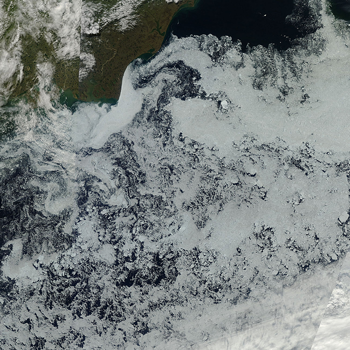
Figure 4. This image from the Moderate Resolution Imaging Spectroradiometer (MODIS) shows areas of low concentration sea ice in the Beaufort Sea, north of Alaska. Barrow, Alaska is at the top left. The resolution is 500 meters. The cloud band covering much of the lower right part of the image is associated with an approaching storm. ||Credit: NASA Goddard Space Flight Center, Rapid Response|{a href=http://nsidc.org/asina/images/Figure4_july_2012.png}High-resolution image{/a}|

