This summer, Arctic sea ice loss was held in check by relatively cool and stormy conditions. As a result, 2013 saw substantially more ice at summer’s end, compared to last year’s record low extent. The Greenland Ice Sheet also showed less extensive surface melt than in 2012. Meanwhile, in the Antarctic, sea ice reached the highest extent recorded in the satellite record.
Overview of conditions

Figure 1. Arctic sea ice extent for September 2013 was 5.35 million square kilometers (2.07 million square miles). The magenta line shows the 1981 to 2010 median extent for that month. The black cross indicates the geographic North Pole. Sea Ice Index data. About the data
Credit: National Snow and Ice Data Center
High-resolution image
Arctic sea ice extent reached its annual minimum on September 13. After the minimum, extent remained largely unchanged for much of the middle of September, but increased rapidly toward the end of the month with the onset of strong autumn cooling.
Arctic sea ice extent averaged for September 2013 was 5.35 million square kilometers (2.07 million square miles). This was 1.17 million square kilometers (452,000 square miles) below the 1981 to 2010 average extent. September 2013 ice extent was 1.72 million square kilometers (664,000 square miles) higher than the previous record low for the month that occurred in 2012.
Conditions in context

Figure 2. The graph above shows Arctic sea ice extent as of September 30, 2013, along with daily ice extent data for the previous five years. 2013 is shown in light blue, 2012 in green, 2011 in orange, 2010 in light purple, 2009 in dark blue, and 2008 in dark purple. The gray area around the average line shows the two standard deviation range of the data. Sea Ice Index data.
Credit: National Snow and Ice Data Center
High-resolution image
The rate of ice loss varied through the summer. Both May 2012 and May 2013 saw near average extents and rates of decline. This year, the rate of ice loss sped up in late June and early July, then settled into a near-average rate of decline, with extent approximately 500,000 square kilometers (193,000 square miles) greater than the same time in 2012. Ice loss then slowed down in August to only a little faster than average rates of loss for that time of year. In comparison, during 2012, the rate of loss accelerated in early June and through July, then accelerated even more in August to produce a new record low extent in September 2012.
Overall, 10.03 million square kilometers (3.87 million square miles) of ice were lost between the 2013 maximum and minimum extents. This was the seventh summer that more than 10 million square kilometers of ice extent were lost; all but one of the seven (the summer of 1990) have occurred since 2007.
September 2013 compared to previous years

Figure 3. Monthly September ice extent for 1979 to 2013 shows a decline of 13.7% per decade.
Credit: National Snow and Ice Data Center
High-resolution image
September average sea ice extent for 2013 was the sixth lowest in the satellite record. The 2012 September extent was 32% lower than this year’s extent, while the 1981 to 2010 average was 22% higher than this year’s extent. Through 2013, the September linear rate of decline is 13.7% per decade relative to the 1981 to 2010 average.
What a difference a year makes
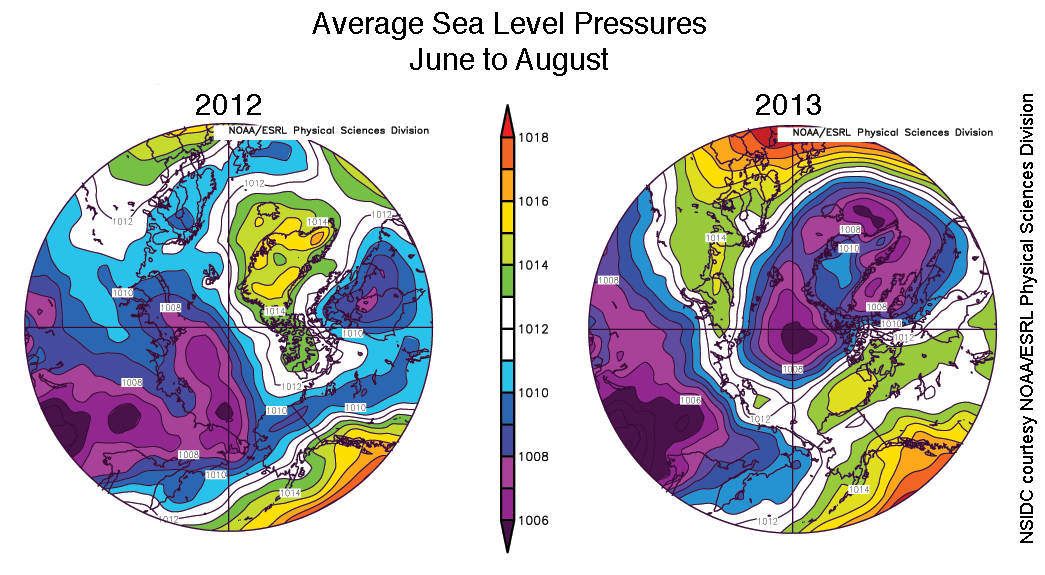
Figure 4. These images show June to August sea level pressures compared to the 1981 to 2010 average, for 2012 (left) and 2013 (right). In 2013, low pressures prevailed over the central Arctic Ocean and Greenland. Blues and purples indicate low pressures, while greens, yellows, and reds indicate high pressures.
Credit: National Snow and Ice Data Center courtesy NOAA/ESRL Physical Sciences Division
High-resolution image
Contrasting weather conditions were a significant factor in this year’s higher sea ice extent and lower Greenland Ice Sheet melt intensity, compared to last year. This summer saw air temperatures at the 925 hPa level that were 1 to 3 degrees Celsius (2 to 5 degrees Fahrenheit) lower than last summer. It was also a cool summer compared to recent years over much of the Arctic Ocean, and even cooler than the 1981 to 2010 average in some regions, particularly north of Greenland.
While 2012 and 2013 extents were similar through May, weather patterns from June to August helped retain more ice. Last summer was marked by lower than average pressure over the Eurasian side of the Arctic and higher than average pressure over Greenland. This resulted in a dipole-like wind pattern that favored ice transport across the ocean and the import of heat from southern latitudes along the Eurasian side of the Arctic. In contrast, this summer was characterized by unusually low pressure over much of the Arctic Ocean, which limited heat import from the south and brought more extensive cloud cover, keeping temperatures lower. In addition, the winds associated with the low pressure caused the ice cover to spread out and cover a larger area.
Over land, the cool spring resulted in greater than average March and April snow cover for the Northern Hemisphere. However, as in recent years, the snow melted rapidly, and by May, snow cover was at near record lows. Cooler weather conditions also limited surface melt on the Greenland Ice Sheet, which was still greater than the 1981 to 2010 average, but not near the record set in 2012 (see our Greenland Ice Sheet Today post for more details).
Ice thickness and age
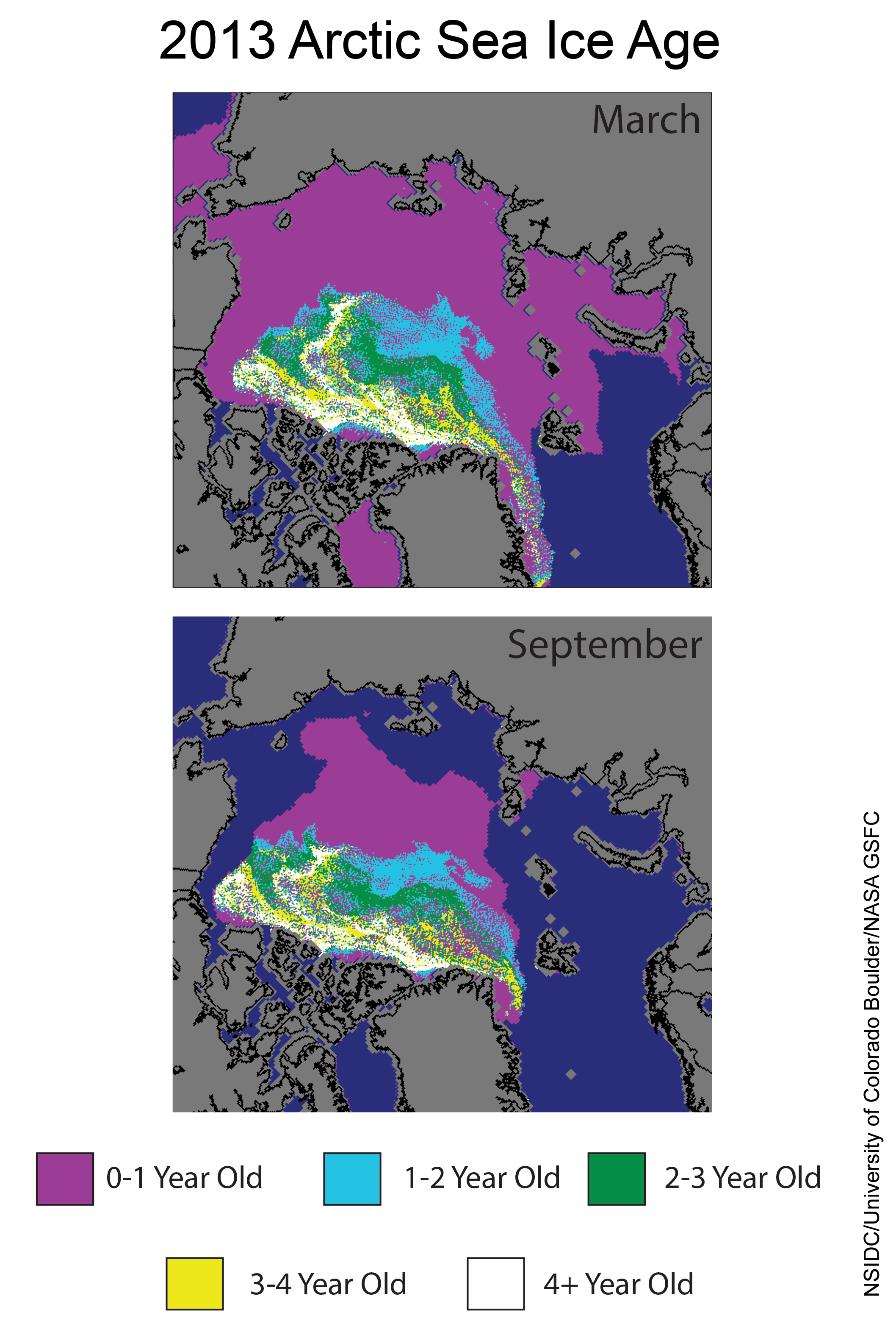
Figure 5. These images from March 2013 (top) and September 2013 (bottom) show the changes in multiyear ice between this year’s sea ice maximum and minimum extents. In contrast to 2012, the record low extent year, multiyear ice tended to stay put, rather than being circulated around, which can expose it to warmer currents and winds that increase melt. Much of the Arctic ice cover now consists of first-year ice (shown in purple), which tends to melt rapidly in summer’s warmth.
Credit: NSIDC courtesy Mark Tschudi, University of Colorado Boulder and Walt Meier, NASA Goddard Cryospheric Sciences
High-resolution image
The pattern of ice thickness for the summer of 2013 is similar to what has been seen in recent years. According to data from the European Space Agency CryoSat-2 radar altimeter, the spring melt season started with an Arctic ice cover thinner than in any recent year. This corroborates thickness information inferred from a calculation of ice age that showed first-year ice, which is thinner and more vulnerable to melt, over a significant part of the Arctic Ocean as the melt season started (see our earlier post). Older, thicker ice remained in a region roughly between the North Pole and the Canadian Archipelago and the Greenland coast.
In recent summers, there has been considerable transport of older ice into the Beaufort and Chukchi seas, where it has been broken up and exposed to a warm ocean and high air temperatures. This has been a major factor in the loss of multiyear ice over the last decade. This year was notably different. Because this year’s wind pattern was different than 2012, the multiyear ice largely remained in a compact area along the Canadian Archipelago and did not circulate into the Beaufort and Chukchi seas. The cooler conditions this summer also helped preserve more of the first-year ice through the summer.
The first-year ice that survived the summer, now defined as second-year ice, will thicken through autumn and winter. However, it would take several more cool years in a row to build the ice cover back to the state it was in during the 1980s, which consisted of a larger proportion of thicker, multiyear ice that was more resistant to melt. While ice in the Arctic will thicken through this autumn and winter, winds may also transport some of the thicker ice out of the Arctic Ocean and into the North Atlantic.
Another record high in the Antarctic

Figure 6. Antarctic sea ice extent for September 2013 was 19.77 million square kilometers (7.63 million square miles). The magenta line shows the 1981 to 2010 median extent for that month. The black cross indicates the geographic South Pole. Sea Ice Index data. About the data
Credit: National Snow and Ice Data Center
High-resolution image
Antarctic sea ice extent reached 19.47 million square kilometers (7.52 million square miles) on September 22, a record high maximum extent relative to the satellite record, and slightly above the previous record high set last year. This year’s maximum extent was 3.6% higher than the 1981 to 2010 average Antarctic maximum, representing an ice edge that is 35 kilometers (approximately 22 miles) further north on average. Overall, Antarctic September sea ice extent is increasing at 1.1% per decade relative to the 1981 to 2010 average. This increase is likely due to a combination of factors, including winds and ocean circulation. A recent paper by our colleague Jinlun Zhang at the University of Washington concludes that changes in winds are resulting in both more compaction within the ice pack and more ridging, causing a thickening of the pack and making it more resistant to summer melt.
Table 1: Previous Arctic sea ice extents for the month of September *
| Year | Average Arctic Sea Ice Extent for September | Trend, in % per decade (relative to 1981-2010 avg.) | |
|---|---|---|---|
| in millions of square kilometers | in millions of square miles | ||
| 2007 | 4.30 | 1.66 | -11.0 |
| 2008 | 4.73 | 1.83 | -11.0 |
| 2009 | 5.36 | 2.08 | -12.0 |
| 2010 | 4.90 | 1.90 | -12.4 |
| 2011 | 4.63 | 1.79 | -12.0 |
| 2012 | 3.63 | 1.40 | -14.0 |
| 2013 | 5.35 | 2.07 | -13.7 |
| 1979 to 2000 average | 7.04 | 2.72 | |
| 1981 to 2010 average | 6.52 | 2.52 | |
* Note that the dates and extents of the minimums have been re-calculated from what we posted in previous years; see our Frequently Asked Questions for more information.
Reference
Zhang, J. In press. Modeling the impact of wind intensification on Antarctic sea ice volume. J. Climate, doi:10.1175/JCLI-D-12-00139.1.

