January 2022 snow summary
- Snow-covered area was the second lowest in the 22-year satellite record.
- All western states and large river basins had below average snow cover.
- As of January 31, snow cover days hit a record low, surpassing the previous record low year of 2015.
- Snow water equivalent (SWE) was below average at 30 percent of stations on January 1; by January 31, half of all stations reported below average snowpack.
- Relative to average conditions, both snow cover and SWE declined over the last three weeks of January because of a persistent atmospheric ridge that diverted storms north into Canada and Alaska.
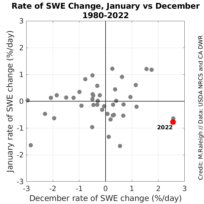
- As a percent of average, SWE increased at a historically high rate through December but decreased in January; this abrupt shift was the most dramatic in the 43-year record.
Overview of conditions
| Snow-Covered Area | Square Kilometers | Square Miles | Rank |
|---|---|---|---|
| January 2022 | 621,000 | 240,000 | 21 |
| 2001 to 2022, Average | 911,000 | 352,000 | -- |
| 2008, Highest | 1,256,000 | 485,000 | 1 |
| 2012, Lowest | 565,000 | 218,000 | 22 |
| 2021, Last Year | 663,000 | 256,000 | 18 |
Averaged over the western United States, snow-covered area in January 2022 was 32 percent below average for January over the 22-year satellite record and was the second lowest on record (Table 1). This is the second year in a row with low snow cover in January, with 2022 having about 6 percent less than 2021. The lowest January snow cover was in 2012, while the highest was in 2008, when there was about twice as much snow cover as in 2022.
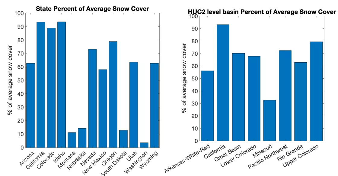
Below average snow-covered area was prevalent in all thirteen states across the western United States (Figure 1). Snow cover in California and Idaho was only slightly below average, at above 90 percent of average, while Colorado was not far behind with above 85 percent of average. The greatest departures from the average snow-covered area were found along the plains of western Nebraska and South Dakota. Most of the other western states had snow-covered area ranging between 55 to 80 percent of average for January. Across all eight large river basins (hydrologic unit code 2 or HUC2 basins) in our analysis region, January snow cover was below average. The California and Upper Colorado basins were the only large river basins with snow cover exceeding 75 percent of average. Most other basins were at 55 to 75 percent of average. For northern areas, there is a known issue with missing satellite data during this time of year (see previous article), and this continues to influence the statistics for Washington and Montana, and the Pacific Northwest and Missouri basins. Hence, caution is warranted in interpreting those results.
Conditions in context: snow cover
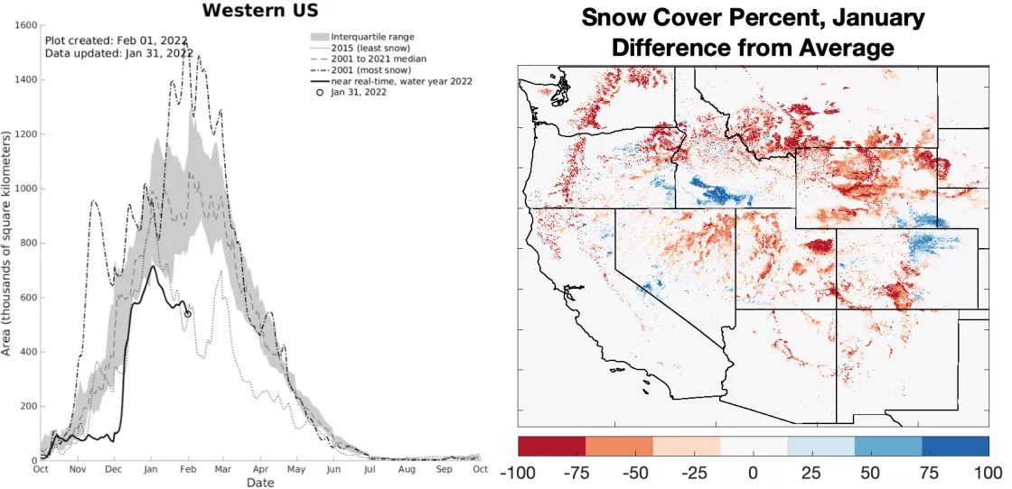
After a delayed start to the snow season, snowstorms in late December 2021 and early January 2022 greatly increased the snow-covered area over the western United States. This momentum was short-lived, as snow cover stopped increasing by the second week in January (Figure 2, left, solid black line). The lack of snowstorms from mid-to-late January has been attributed to a persistent ridge of high pressure off the west coast. With this dominating atmospheric pattern, storms were diverted northward to Canada and Alaska. Snow cover in the western states thus declined through the remainder of January, and the month ended with its lowest amount for 2022.
Areas with below average January snow cover were widespread across the western United States (Figure 2, map on right, red areas). Expansive areas with below average snow cover were found in most states, with notable examples in Utah and much of Wyoming and southern Colorado. A few regions bucking this low-snow pattern (blue colors) were the Snake River Plain of southern Idaho, the northern Front Range in Colorado, and southeastern Wyoming. Overall, the red areas on the difference map far outweigh the blue areas, indicating below average snow cover across the region (Table 1).
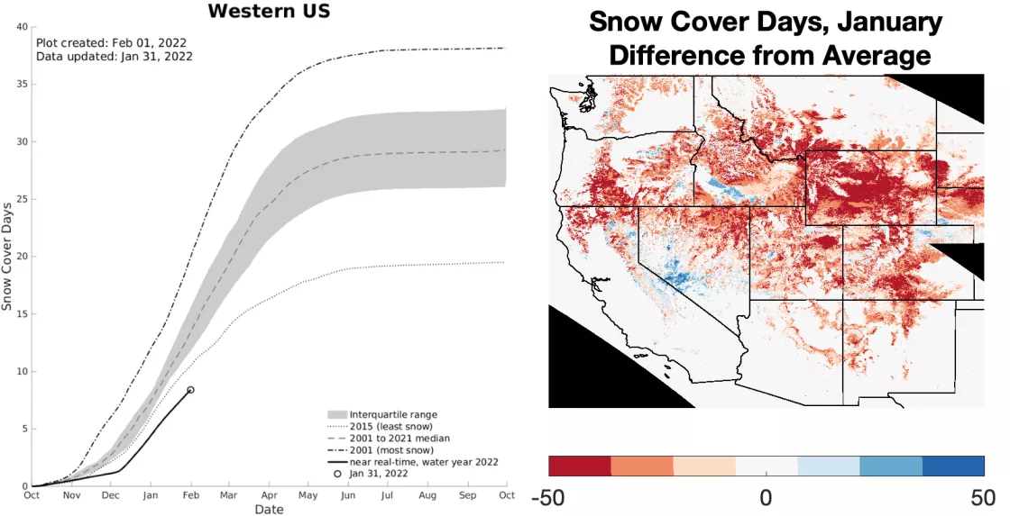
Averaged over the western United States, the number of snow cover days from October 1 to January 31 continued to stay at exceptionally low levels (Figure 3, left). The data suggest that the 2022 snow season surpasses 2015 for the lowest snow cover days through the end of January, based on the 22-year satellite record. The map of the differences in snow cover days, relative to average from October 1 to January 31 (Figure 3, right), further illustrates the low snow cover days over a broad geographic domain. The spatial patterns in snow cover days and snow-covered area are similar at this time of year (compare Figures 2 and 3). Because snow cover days is a time integrating metric, that map more strongly highlights the lack of snow through the full snow season.
Conditions in context: snow water equivalent (SWE)
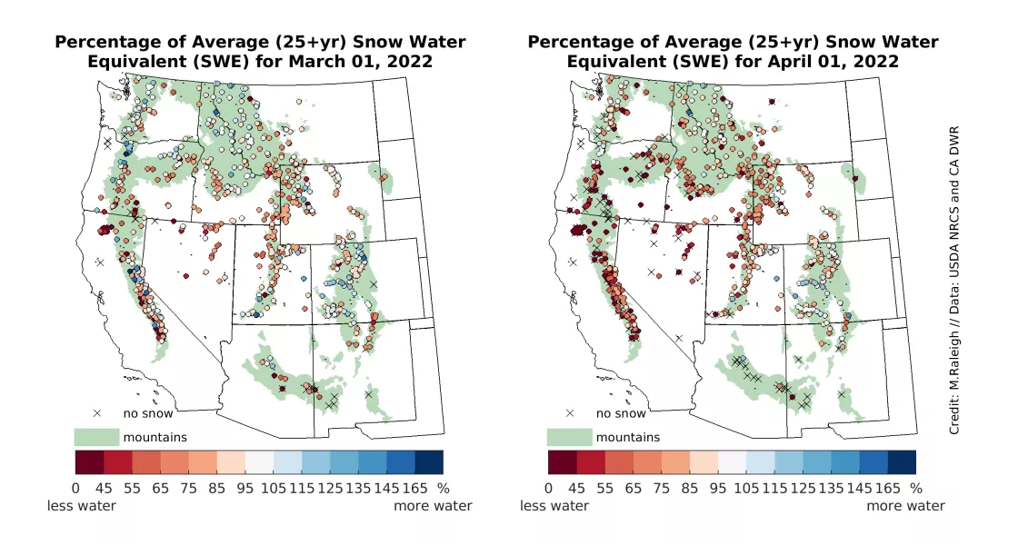
As January 2022 began, snow water equivalent (SWE) was above average at about 70 percent of the measuring stations (Figure 4, left). SWE was well above average broadly across the California Sierra Nevada and in localized areas in northern Oregon and southern Washington, the Uinta Mountains in Utah, parts of the central Rockies of Colorado, and parts of the Mogollon Rim in Arizona. By the end of January, the SWE was not as high (relative to average) at most of these locations (Figure 4, right). This deficit in SWE was caused by the persistent high-pressure ridge, discussed earlier, that shunted storm systems north into Canada and Alaska, resulting in below average snowfall to the south. A handful of stations in California, Oregon, and Washington even recorded a net loss of SWE in January (no figure shown), suggesting mid-winter snowmelt occurred at those locations. At the end of January, the proportion of stations with average or above average SWE dropped to 50 percent.
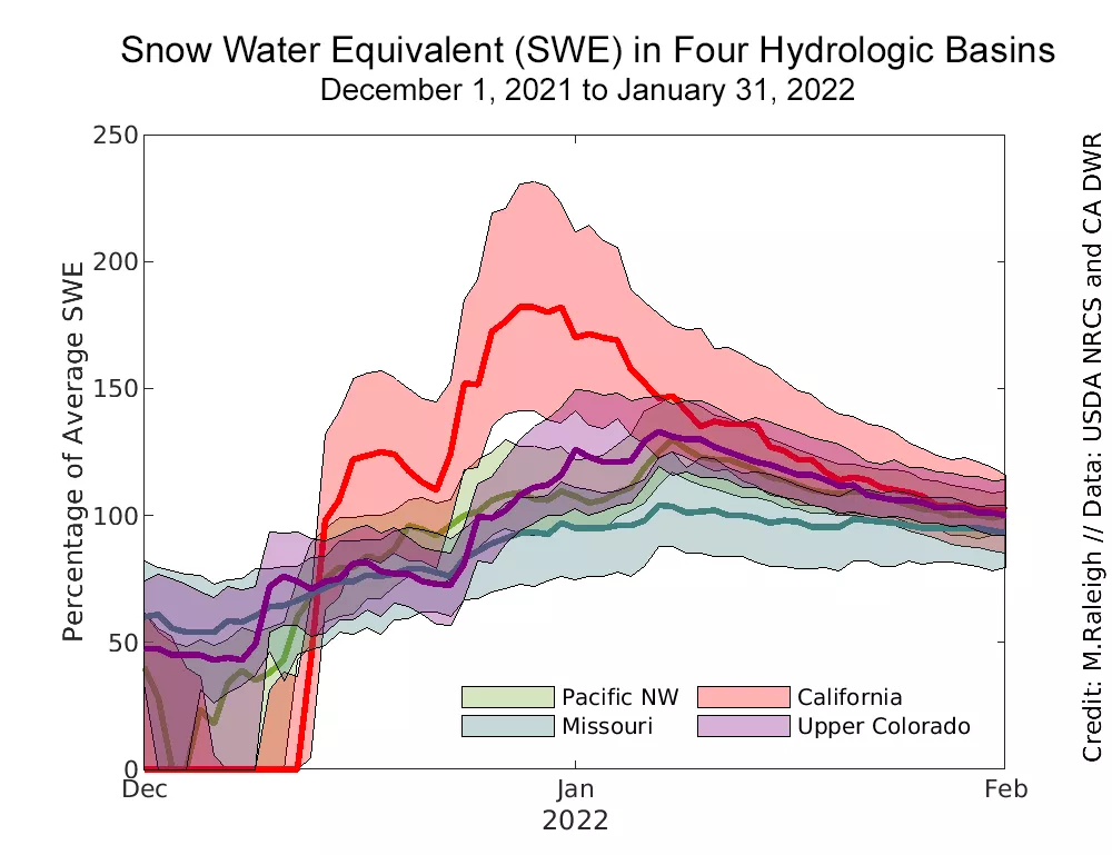
The maps in Figure 4 provide snapshots of SWE at the beginning and end of January. To illustrate the full progression, we examine the distribution of SWE (percentage of average) over four large (HUC2) river basins (Figure 5). These include the northern (Pacific NW Basin) and southern (California Basins) regions in the Pacific states, and the northern (Missouri Basin) and southern (Upper Colorado Basin) regions in the interior states. In all four basins, SWE was increasing at the end of December, with three of the four showing above average SWE as January began. The high SWE (relative to average) peaked in California in late December and in the other three basins by the end of the first week of January. Subsequently, SWE (as a percentage of average) declined steadily through the remainder of the month in all four basins, ending the month at average or just below average SWE. This illustrates a sort of “regression to the mean,” where the headline-grabbing storms and gains in SWE weeks earlier have been offset by the subsequent dry conditions.
December 2021 and January 2022 describe a tale of two distinctly different months in terms of relative SWE accumulation. Stations in the Upper Colorado Basin increased from about 50 percent to 125 percent of average SWE through December (a +75 percent monthly swing or 2.4 percent per day), but then dropped down to 100 percent of average SWE by the end of January (a -25 percent swing or -0.8 percent per day). We examined the difference in the rate of change in SWE percentage through each month, comparing January versus December across the full 43-year record and all stations across the western United States (Figure 6). This analysis shows a sharp contrast between a snowy December 2021 versus a dry January 2022. December tied for the snowiest month on record in the western United States, which was followed by an unusually dry January (among the five driest in this analysis). A comparable analogue to 2022 is 2009, which also had a relatively dry January that came after a notably wet December (Figure 6). While both December 2008 and December 2021 were comparable in terms of high gains in SWE, January 2022 was marginally drier than January 2009. By the metrics used in this simple analysis, the recent and abrupt shift in west-wide SWE conditions from December to January is historic.
