Sea ice extent for February 2021 tracked well below average, but at month’s end was still higher than levels recorded in several recent years. Extent grew at an average pace.

Sea Ice Today
Analyses
Arctic sea ice extent for January 2021 tracked below average, with the monthly average finishing sixth lowest in the satellite record.
The Arctic climate was extraordinary in 2020, but the year ended with a less spectacular December.
Entering December, which is the start of winter in the Northern Hemisphere, sea ice extent remains far below average, dominated by the lack of ice on both the Pacific and Atlantic sides of the Arctic Ocean.
A vast area of the Arctic Ocean remains ice free as November begins, far later in the season than is typical. The monthly average ice extent for October is the lowest in the satellite record.
Following the sea ice extent minimum on September 15, 2020, expansion of the ice edge has been most notable in the northern Chukchi and Beaufort Seas. The ice edge along the Laptev Sea continued to retreat farther.
On September 15, Arctic sea ice likely reached its annual minimum extent of 3.74 million square kilometers (1.44 million square miles).
In the first week of September, sea ice extent took a sharp downward turn, exceeding the pace of decline for any previous year during that period, and placing the 2020 sea ice minimum firmly as second lowest—after 2012—in the 42-year continuo
After a period of rapid sea ice loss extending into the last week of August, the rate has slowed with the onset of autumn in the Arctic. A region of low concentration ice persists in the Beaufort Sea.
While the Arctic summer is waning, sea ice extent continues to drop. In early August, ice-free pockets began to develop in the Beaufort and Chukchi Seas and expanded steadily through the first half of the month.
The fast pace of ice loss observed in the beginning of July continued through the third week of July, after which the ice loss rates slowed dramatically.
By July 15, 2020, Arctic sea ice extent was at a record low over the period of satellite observations for this time of year.
The Siberian heat wave continued into June with a record high temperature in Verkhoyansk, just north of the Arctic Circle. The heat also affected the Laptev Sea, where ice extent dropped to a record low for this time of year.
The seasonal decline of Arctic sea ice extent proceeded at a near-average pace in May. Extent did not approach record lows but remained well below the 1981 to 2010 average.
The pace of sea ice decline in April was near average, while sea ice extent ranked fourth lowest in the satellite record.
After reaching its annual maximum on March 5, Arctic sea ice extent remained stable for several days before it started clearly declining. Continuing the pattern of this past winter, the Arctic Oscillation was in a persistently positive phase.
Arctic sea ice appears to have reached its annual maximum extent on March 5.
Sea ice extent for February 2020 tracked below average, ranking as the thirteenth lowest monthly average in the satellite record. A brief pause in ice growth in the middle of February was related to the regional wind pattern.

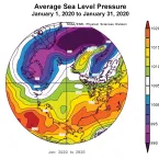
Sea ice extent for January 2020 tracked well below average, with the monthly average tied at eighth lowest in the satellite record.

The year 2019 saw an early melt onset and high sea surface temperatures during summer in the Beaufort and Chukchi Seas. The September minimum extent ended up tied with 2007 and 2016 for second lowest in the satellite record.