March 2022 snow summary
- Snow-covered area for the western United States was 97 percent of average for March but varied regionally with above-average area in central continental regions and below-average area in coastal and northern regions.
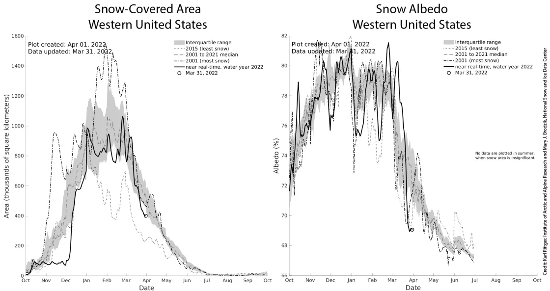
- In early March, snow reflectivity, known as snow albedo, was high with winter-like conditions. From mid- to late-March, snow albedo decreased rapidly, thus increasing snowmelt, exposing light-absorbing particles, and further decreasing snow albedo.
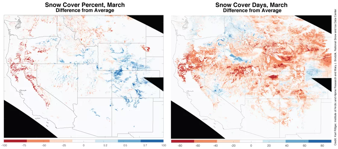
- Snow cover days remained well below average across the western United States except for a few regions like Washington and northern Idaho.
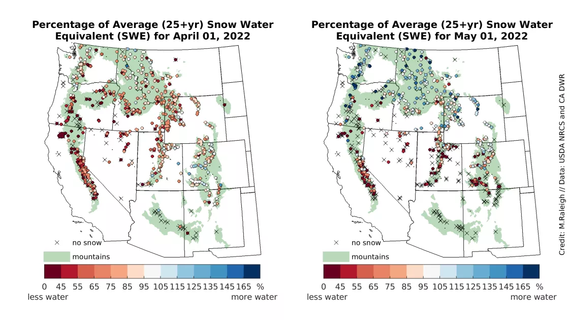
- At the end of March, snow water equivalent (SWE) was below average at 88 percent of stations in the western United States.
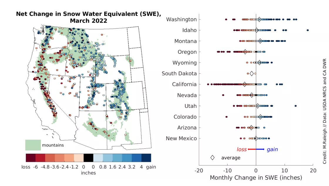
- All western states had stations reporting net SWE losses caused by snowmelt through March, with the greatest and most widespread SWE losses found in California and Oregon.
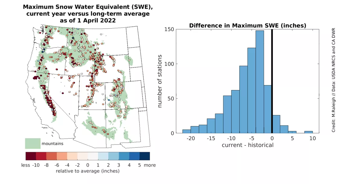
- Maximum SWE to date is below the long-term average at most stations in the western United States, presenting implications for water availability in the months ahead.
Overview of conditions
| Snow-Covered Area | Square Kilometers | Square Miles | Rank |
|---|---|---|---|
| March 2022 | 643,000 | 248,000 | 14 |
| 2001 to 2022, Average | 663,000 | 256,000 | -- |
| 2019, Highest | 1.06 million | 409,000 | 1 |
| 2015, Lowest | 367,000 | 142,000 | 22 |
| 2021, Last Year | 656,000 | 253,000 | 12 |
In March 2022, the average snow-covered area in the western United States was 97 percent of average. While snow water equivalent (SWE) typically peaks near April 1 in the western US mountains, depending on the location, snow-covered area peaks in February. This year, snow-covered area is rapidly decreasing in March as relatively low-elevation snow begins to melt. For example, in February 2022, the snow-covered area spanned 820,000 square kilometers (317,000 square miles), while that in March covered 643,000 square kilometers (248,000 square miles). March snow-covered area was 39 percent below that in 2019 and 75 percent greater than that in 2015, the years with the highest and lowest recorded snow-covered areas, respectively.
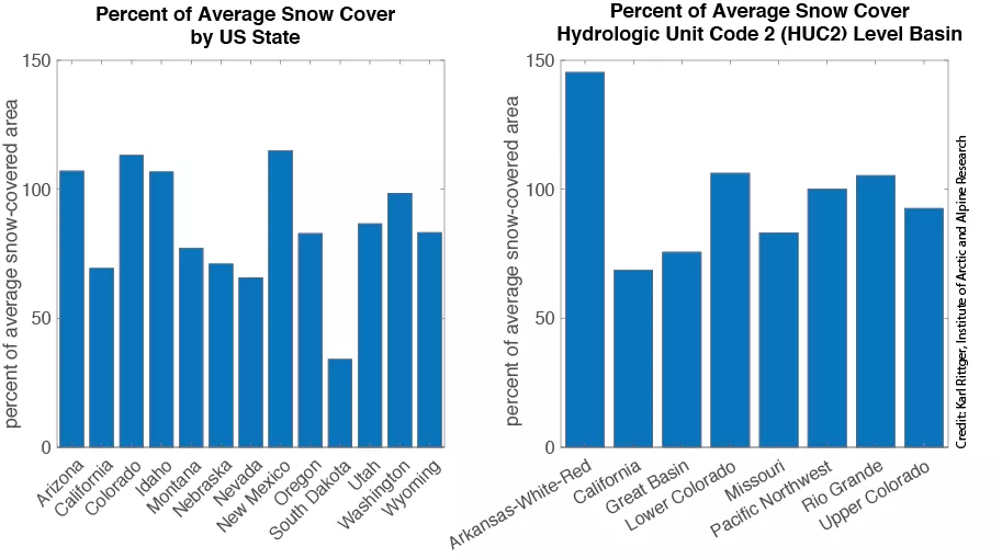
While snow-covered area was near average across the western United States, there is considerable variation across the 13 western states and eight large river basins in our analysis region. Relative to average, the western part of South Dakota had the lowest average snow-covered area, at only 34 percent of average, while New Mexico had the highest average snow-covered area, at 115 percent of average. Colorado and Idaho also had above-average snow-covered area while all other states were below-average. For large river basins, the Arkansas-White-Red basin had the highest relative snow cover with 145 percent of average. While this seems like a considerable amount of snow, it corresponds to only about 15,000 square kilometers (5,800 square miles) versus the average of 10,000 square kilometers (3,900 square miles). When compared to the total snow cover across the western United States (Table 1), this is not a significantly sized region. The Pacific Northwest, Lower Colorado, and Rio Grande basins had near-average conditions. The remaining basins were below-average.
Conditions in context: snow cover
Snowstorms in the early part of March 2022 briefly increased the snow-covered area above that observed in March 2001, the year with the highest total snow cover area averaged across the entire year (Figure 2, left). However, as the month progressed, few storms added to the existing snow cover. The snowstorms that occurred in early March covered older, darker snow with bright new snow. As a result, snow reflectivity, or snow albedo, increased temporarily to near average values for mid-winter (Figure 2, right) or above average for early spring. However, as the month progressed, snow albedo decreased rapidly as the snow aged and its surface darkened. The melting surface snow exposed more light-absorbing particles on the snow surface in some locations. As snow ages and light-absorbing particles are exposed, the amount of solar energy absorbed by the snow surface increases, creating a positive feedback effect in which the two processes mutually progress, driving the declines in snow-covered area and snow albedo (Figure 2, right).
In March, very strong regional patterns in snow cover area relative to average appeared, with some regions having above average snow and others having below average snow (Figure 3, left). By contrast, the current tally of snow cover days summed from October 1, 2021, to March 31, 2022, generally showed significantly less variability and fewer snow cover days than average (Figure 3, right). Coastal regions like California, Oregon, and Washington had below-average snow cover percentages, as did northern Idaho and Montana (Figure 3, left). More easterly states in our analysis region, such as Colorado, New Mexico, Arizona, and southern Idaho, exhibited above-average snow cover percentages (Figure 3, left). Snow cover days were broadly negative relative to average across the western United States except in Washington and northern Idaho as well as in some relatively small regions in southern Idaho, the eastern Colorado plains, and a few areas east of in the Sierra Nevada in California and in western Nevada near the White Mountains (Figure 3, right).
Conditions in context: snow water equivalent (SWE)
At the start of March 2022, snow water equivalent (SWE) was below average at 76 percent of stations across the western United States (Figure 4, left). By the end of March, below-average SWE was reported at 88 percent of stations and in all twelve western states on a statewide-average basis (Figure 4, right). SWE declined substantially—to 60 percent of average or less—in many places, such as in broad areas of the California Sierra Nevada, the southern Cascades and Blue Mountains of Oregon, Utah, Nevada, and South Dakota. By the end of March, the snowpack had melted out at most stations in Arizona and at over half of the stations in New Mexico. Increasingly variable SWE conditions were found at the end of the month in some states, such as Colorado, Washington, Idaho, and Montana. For example, near-average SWE was recorded along the Idaho-Montana border, but below-average SWE was found farther to the southwest in Idaho and to the southeast in the Montana mountains. On a statewide-average basis, Colorado had the closest-to-average SWE at the end of March, at about 90 percent of average, followed by Washington with about 80 percent of average. Both states showed variable conditions, with below-average SWE recorded in the northern half of Colorado west of the Front Range, and at locations east of the Cascades and in the Olympic Mountains of Washington.
A broad southwest-to-northeast pattern was observed in the net SWE changes throughout the month of March (Figure 5, left). Several locations in California, Oregon, Arizona, and New Mexico showed more snowmelt than new snowfall, resulting in net SWE losses throughout the month (Figure 5, right). Snowmelt was most severe and widespread in California and was observed to a lesser extent in Oregon; the net SWE losses recorded at several stations in both states exceeded 25 centimeters (10 inches). By contrast, more northerly and easterly locations—such as Washington, Montana, Wyoming, and Colorado—had more new snowfall than snowmelt, resulting in net SWE gains over the month (Figure 5, right). A few sites in Washington, Idaho, and Montana showed net SWE increases of 25 centimeters (10 inches). Colorado exhibited the greatest net SWE gain recorded on a statewide basis. However, the gain of 3.8 centimeters (1.5 inches) was quite meager. For comparison, Colorado SWE increased by nearly double this amount in March of last year (March 2021). Interior stations located in Idaho, Nevada, and Utah recorded mixtures of net SWE gains and losses. All twelve western states had multiple stations reporting net SWE losses throughout March (Figure 5, right; red markers), indicating that the snowmelt season is underway in much of the western United States.
Maximum snow water equivalent: a shortfall?
In the western United States, the annual maximum SWE is an important indicator of the water supply, and the SWE maximum typically occurs within a few weeks of April 1. However, the average timing of maximum SWE varies regionally. The maximum SWE values recorded at each station are compared in the analysis region through the start of April 2022, against the corresponding long-term averages (minimum 25 years). Across most of the domain, the maximum SWE values recorded in 2022 are below the long-term maximum SWE (Figure 6, left). These shortfalls are notable in the California Sierra Nevada and throughout parts of the Cascade Range in Washington and Oregon. These coastal mountainous regions typically exhibit maximum SWE in mid-to-late March and are therefore unlikely to see sufficient new snow in the coming weeks to bring the 2022 snowpack to average maximum SWE. Below-average maximum SWE is also apparent in some continental locations (Figure 6, left). In these regions, maximum SWE typically occurs closer to April 1 (e.g., in Nevada and Idaho) or within the first two weeks of April (e.g., in Utah, Colorado, and Wyoming), and thus a few stations may have not yet reached their maximum for 2022.
At more than 90 percent of the stations in the western United States, the maximum SWE recorded in 2022 was below the long-term average (Figure 6, right). When averaged over the entire station network, the regionally averaged maximum SWE value was found to be 13.2 centimeters (5.2 inches) below the long-term average. With snowmelt already underway in many areas (Figure 5), there is little time left for new snow accumulation. The 2022 snow deficit may have significant implications for water availability this summer.
