ICESat-2
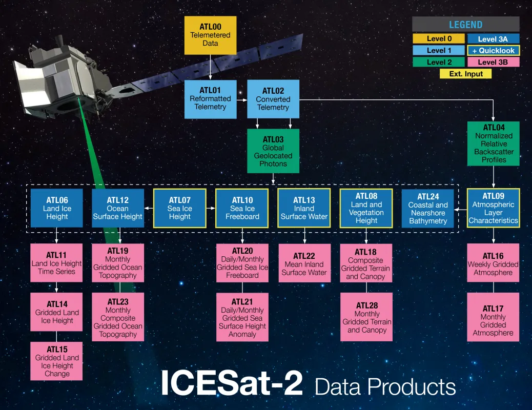
ATLAS/ICESat-2 processing begins with two Level 1 products: ATL01, which computes photon times of flight, and ATL02, which corrects them for temperature and voltage effects.
The collection then branches out into two, Level 2 scientific data products: one that reports latitude, longitude, and elevation for each photon (ATL03) and a second with atmospheric profiles of normalized relative backscatter (ATL04).
After Level 2, the ATLAS/ICESat-2 Level 3 products comprise surface-specific data products for land ice, sea ice, the atmosphere, vegetation and land, and oceans and inland water.
The following descriptions provide brief summaries of all published ICESat-2 data products. Each data set has a User Guide and Algorithm Theoretical Basis Document (ATBD) with detailed information for data users. Both documents are available on the corresponding product landing page.
Level 1 ICESat-2 Products
Reformatted Telemetry (ATL01)
Raw ATLAS/ICESat-2 data are decompressed, ordered in time, and reformatted to HDF5. ATL01 consists of all the ICESat-2 data downlinked by the X-band telemetry stream in a bit-decompressed, time-aligned, product.
ATL01 contains all the pertinent information related to:
- altimetry
- the atmosphere
- the laser reference system
- housekeeping data
- calibration mode
- spacecraft ancillary science data
ATL01 is generated as input for the Level 1B product and for use by researchers who require ATLAS/ICESat-2 data at the lowest possible level.
Science Unit Converted Telemetry (ATL02)
ATLAS/ICESat-2 Level 1B processing applies instrument corrections to the ATL01 data, such as removing biases in timing and pointing measurements and correcting for the effects of temperature and voltage variations on the ATLAS electronics.
The primary function of ATL02 is to:
- Record radiometric parameters for system–level, quality control analysis
- Support the Precise Pointing Determination (PPD) and the Precise Orbit Determination (POD) processing
- Provide source data for the Level 2 global geolocated photons product (ATL03)
- Provide raw atmospheric profiles for each strong beam to the Level 2 normalized relative backscatter product (ATL04)
Level 2 ICESat-2 Products
Global Geolocated Photon Data (ATL03)
ATL03 provides height above the ellipsoid, time, geodetic latitude and longitude for individual photons. Heights are provided in the ITRF2014 reference frame. Geographic coordinates are referenced to the WGS84 ellipsoid. Heights are corrected for several geophysical phenomena, such as effects of the atmosphere and solid earth deformation.
ATL03 also contains five surface masks—land, land ice, ocean, sea ice, and inland water—that collectively cover Earth's surface.
Normalized Relative Backscatter (ATL04)
ATL04 provides along-track, normalized relative backscatter (NRB) profiles of the atmosphere that can be used to identify atmospheric layers and their boundaries, including clouds, aerosols, and blowing snow.
Level 3a ICESat-2 Products
Land Ice Height (ATL06)
ATL06 provides along-track geolocated land-ice surface heights and ancillary parameters that can be used to interpret and assess the quality of the height estimates.
Sea Ice Height (ATL07)
ATL07 provides along-track surface height and type (e.g., snow-covered ice, open water) for the ice-covered seas of the northern and southern hemispheres.
Land and Vegetation Height (ATL08)
ATL08 provides along-track geolocated terrain height, canopy height, and canopy cover.
Calibrated Backscatter Profiles and Atmospheric Layer Characteristics (ATL09)
ATL09 provides along-track calibrated attenuated backscatter (CAB) profiles, layer integrated attenuated backscatter, plus other parameters including cloud layer height and other atmospheric characteristics obtained from the data.
Sea Ice Freeboard (ATL10)
ATL10 provides along-track sea ice freeboard, calculated using three different approaches, plus sea ice leads used to establish the reference sea surface.
Ocean Surface Height (ATL12)
ATL12 provides along-track sea surface height at variable length scales over cloud-free ocean regions. Estimates of height distribution, significant wave height, and sea state bias are also provided.
Along Track Inland Surface Water Data (ATL13)
ATL13 provides along-track surface water products of inland water bodies: along-track water surface height and standard deviation, subsurface signal (532nm) attenuation significant wave height, wind speed, and coarse depth to bottom topography.
Along Track Coastal and Nearshore Bathymetry (ATL24)
ATL24 provides global along-track coastal and nearshore bathymetry, consisting of refraction-corrected seafloor and sea surface heights.
Level 3b ICESat-2 Products
Slope-Corrected Land Ice Height Time Series (ATL11)
ATL11 provides a spatially organized time series of cross-over and along-track land-ice surface heights, derived from ATL06. Height changes are computed for repeat observations (91 days apart) along individual ICESat-2 ground tracks in polar regions.
Gridded Antarctic and Arctic Land Ice Height (ATL14)
ATL14 is a high-resolution (100 m) digital elevation model (DEM) that provides spatially continuous gridded data of ice sheet surface height. ATL14 data are derived from ATL11.
Gridded Antarctic and Arctic Land Ice Height Change (ATL15)
ATL15 provides quarter-year, land ice height changes for the Antarctic ice sheet and regions around the Arctic gridded at four spatial resolutions (1 km, 10 km, 20 km, and 40 km). ATL15 data are derived from ATL11.
Weekly Gridded Atmosphere (ATL16),
Monthly Gridded Atmosphere (ATL17)
ATL16 and ATL17, both derived from ATL09, provide gridded atmospheric parameters, including global cloud fraction, global aerosol fraction, total column optical depth (over ocean and inland water bodies), polar cloud fraction (total, low, mid, and high altitude, transmissive and opaque clouds), blowing snow frequency (low and high rate), apparent surface reflectivity, and ground detection frequency.
Monthly Gridded Dynamic Ocean Topography (ATL19),
Monthly 3-Month Gridded Dynamic Ocean Topography (ATL23)
ATL19 and ATL23 provide monthly gridded dynamic ocean topography (DOT) over mid-latitude, north-polar, and south-polar grids derived from ATL12. ATL23 contains monthly data averaged over 3 months instead of 1 month in ATL19.
Daily and Monthly Gridded Sea Ice Freeboard (ATL20),
Daily and Monthly Gridded Polar Sea Surface Height Anomaly (ATL21)
ATL20 provides daily and monthly gridded estimates of sea ice freeboard, and ATL21 provides polar sea surface height anomalies. Both data sets are derived from ATL10
Mean Inland Surface Water Data (ATL22)
ATL22 provides mean water surface heights for transects over inland water bodies. ATL22 is derived from ATL13.
