Search, order, and customize NSIDC DAAC data with NASA Earthdata Search
NASA Earthdata Search is a map-based interface where users can search for Earth science data, filter results based on spatial and temporal constraints, and order customized data. Thousands of Earth science data sets are accessible from NASA's 12 science-oriented Distributed Active Archive Centers (DAACs), including the NSIDC DAAC. The NSIDC DAAC distributes several hundred data sets in NASA Earthdata Search, many with customization options.
This article outlines a workflow for searching, ordering, and customizing data in NASA Earthdata Search. This approach is ideal for users who want to use an accessible user-interface to download data to their local machine. This guide will help you:
- Learn to navigate NASA Earthdata Search - Access the interface and learn how to set up your free Earthdata account
- Master search techniques - Discover how to use keywords, filters, and wildcards to find specific datasets
- Apply spatial and temporal filtering - Narrow your search to specific geographic regions and time periods
- Understand data customization options - Learn how to tailor datasets to your specific needs through subsetting, reformatting, and reprojection
- Download data efficiently - Use direct downloads or the Earthdata Download application to retrieve your selected data
- Navigate cloud vs. legacy options - Understand the differences between NASA Earthdata Cloud and Legacy Archive data access
Step 1: Access NASA Earthdata Search
You can access NASA Earthdata Search at https://search.earthdata.nasa.gov. NASA requires you to set up a free Earthdata account to access the data.
Step 2: Search for a data set
Search for a data set in the search box by entering specific key terms such as a mission (e.g. Terra), an instrument (e.g. MODIS), a data set (e.g. NSIDC-0481), and/or science parameter (e.g. snow cover).
In this example workflow, we will use the data set NSIDC-0481.
Filtering by Availability in NASA Earthdata Cloud
Many NSIDC DAAC data sets are now available in NASA’s Earthdata Cloud environment. While data will remain accessible from the NSIDC DAAC's local servers for now, all data sets will eventually migrate to the cloud. We recommend selecting the Earthdata Cloud version of the data set when possible, as it will soon become the permanent and sole archive. You can identify the cloud copy by the Earthdata Cloud icon in the collection description. You can also filter the cloud copy of a data set by selecting “Available in Earthdata Cloud”.
Temporal Filtering
If you want to filter the data set by a time period, click on the Temporal filter button located on the top left side of the page. Fill in the Start and End boxes to specify your date range of interest.
For example, below we've applied a temporal filter for NSIDC-0481 ranging from 12 June 2008 to 12 June 2009.
Spatial Filtering
If you want to filter the data set by geographic region, click the Spatial filter button, located next to the temporal filter on the top left side of the page. You'll see several filtering options including Polygon, Rectangle, Circle, Point, and File.
In the example below, the Rectangle option is used to specify the Southwest and Northeast coordinates corresponding to Greenland.
Click on a matching collection to view its science granules (the smallest units of data that can be independently retrieved, typically representing data for a specific time, location, or observation).
Step 3: Filter and view results of data search
Once the dataset of interest is selected, individual granules can be directly downloaded by clicking on their download arrow. To download multiple granules, click the +/- icons to add or remove the granule to your project collection. The number of selected granules in your project collection will be shown in the blue Download button at the lower right side corner of the results window. If no granules are manually added using the + icon, all granule results matching your current filters will be included in your download. When available, browse imagery can also be viewed by clicking its thumbnail.
Using Wildcards to refine data search
The use of wildcards can be applied to search and filter by filenames:
- Use ? (question mark) to match any one character.
- Use * (asterisk) to match any number of characters in the filename.
- Delimiters (space, comma, or new line) can be used to search on multiple files.
For example, to search all granules in NSIDC-0481 grid W69.10N use *W69.10N* in the Granule Search box. To also include all granules in grid E68.80N to the same search use *W69.10N*, *E68.80N*.
Step 4: Customize and order data
Click on the Download Data button and sign in to NASA Earthdata Search (or register for a new account, if you haven’t already). Once on the ordering page, you can choose the preferred data access method.
Without customization
The example below illustrates the available access option for data sets without customization services, such as NSIDC-0481. This option is the Direct Download method, which offers immediate access to selected granules via links or download scripts. Click "Download Data" to proceed to your Download Status page.
With customization
Customization options may include reformatting, reprojecting, or spatial and parameter subsetting. Not all data sets within data collections offer customization options, and available options are unique to each data set. Additionally, customization options may differ between the same data set in NASA Earthdata Cloud and in the Legacy Archive. Note that customization services for data sets in NASA Earthdata Cloud will continue to be developed, while data sets in the Legacy Archive will gradually be retired.
The following list provides an overview of customizations for each collection. Data sets with customization options in NASA Earthdata Cloud will be specified in the following links. If Harmony customization is not specified, the customization options only apply to the legacy archive:
For data sets offering customization services, an additional Customize option will appear on the ordering page. The available customization options vary depending on the selected data set, and all available options will be presented for your selection.
Customizing NSIDC DAAC Data sets in the NASA Earthdata Cloud
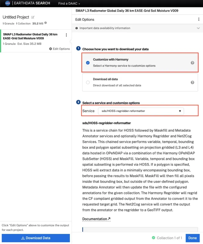
Choose "Customize with Harmony" to enable Harmony-powered services for supported datasets. Available options vary by data set. Two Harmony services available for NSIDC DAAC datasets are the Harmony Trajectory Subsetter and the Harmony sds/HOSS Regridder and Reformatter.
- Harmony Trajectory Subsetter: spatial subsetting and temporal subsetting.
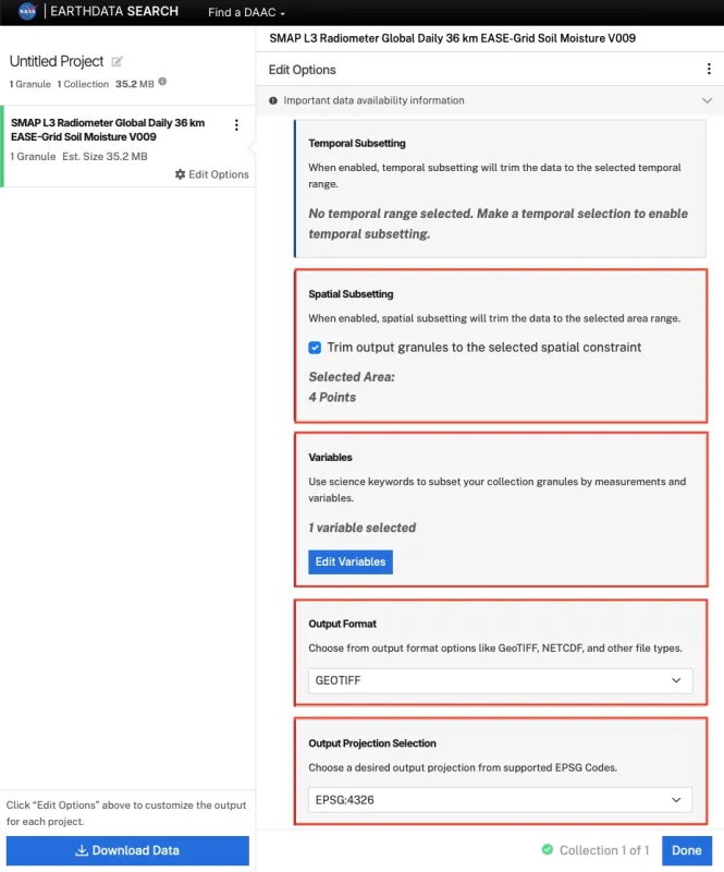
- Harmony sds/HOSS Regridder and Reformatter: spatial subsetting, temporal subsetting, variable subsetting, reprojection options, and reformatting to GeoTIFF.
After choosing your options, click "Done" to proceed to download.
Example 1: ICESat-2 along-track dataset ATL06 with the Harmony Trajectory Subsetter, using a bounding box to subset to the area of interest.
Example 2: SMAP gridded dataset SPL3SMP with Harmony sds/HOSS Regridder and Reformatter (sds/HOSS-regridder-reformatter), selecting one variable, applying a bounding‑box subset, reprojecting to EPSG:4326, and exporting to GeoTIFF.
Customizing NSIDC DAAC Data sets in the Legacy Archive
This section outlines the process for customizing data sets in the legacy on-premises archive. The image below illustrates the ordering page for the on-premises copy of a dataset, with the "Customize" data access method selected.
Choose your desired customization options and click "Done" to proceed to data download.
Step 5: Retrieve data
The Download Status page provides information about your order's progress. For Direct Download and both Customize options, links are displayed directly on the Download Status page.
You can retrieve data by either clicking each of the links provided on the Download Status page or using the Earthdata Download (EDD) application. Clicking the blue “Download Files” button on the download page launches the application. EDD offers a native solution for easily downloading large volumes of data from Earthdata Search. For more information on installing EDD and downloading data, visit the help article How to use Earthdata Download.
The Download Status page may also include tabs to download the browse images, download data using a provided bash script, AWS A3 Access information, or STAC links.
Final Thoughts and Additional Resources
NASA Earthdata Search a user-friendly yet powerful platform for discovering, customizing, and accessing Earth science data from NSIDC DAAC and other NASA archives.
For additional information on cloud-based workflows, we recommend exploring the NASA Earthdata Cloud Cookbook: https://nasa-openscapes.github.io/earthdata-cloud-cookbook/.
Need assistance with NSIDC DAAC data or customization options? Contact us at nsidc@nsidc.org.
For additional instructions on using NASA Earthdata Search, visit the Getting Started page on the Earthdata website.


