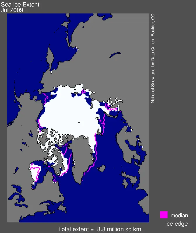
Arctic sea ice extent for the month of July was the third lowest for that month in the satellite record, after 2007 and 2006. The average rate of melt in July 2009 was nearly identical to that of July 2007. A strong high-pressure system, similar to the atmospheric pattern that dominated the summer of 2007, brought warm winds and clear skies to the western Arctic, promoting ice melt.
Overview of conditions
Sea ice extent averaged over the month of July 2009 was 8.81 million square kilometers (3.40 million square miles). This was 680,000 square kilometers (263,000 square miles) above the record low that occurred in July 2007, 250,000 square kilometers (97,000 square miles) below July 2008, and 1.29 million square kilometers (498,000 square miles) below the 1979 to 2000 average. Sea ice extent is unusually low in the Kara Sea, Baffin Bay, and along the Russian coast. The only area with significant above-average ice extent is southern Hudson Bay.
Conditions in context
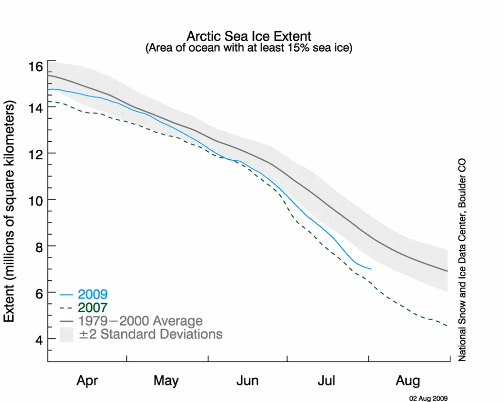
The average pace of ice loss during July 2009 was nearly identical to that of July 2007. Ice loss sped up during the third week of July, and slowed again during the last few days of the month.
Averaged for the month, July 2009 saw a decline rate in ice extent of 106,000 square kilometers (41,000 square miles) per day. For comparison, the rate of decline for July 2007 was 107,000 square kilometers (41,000 square miles) per day and the July 2008 rate of decline was 94,000 square kilometers (36,000 square miles) per day. The Arctic Ocean lost a total of 3.19 million square kilometers (1.23 million square miles) of ice during July 2009, and dropped below ice extent at this time in 2008.
July 2009 compared to past years
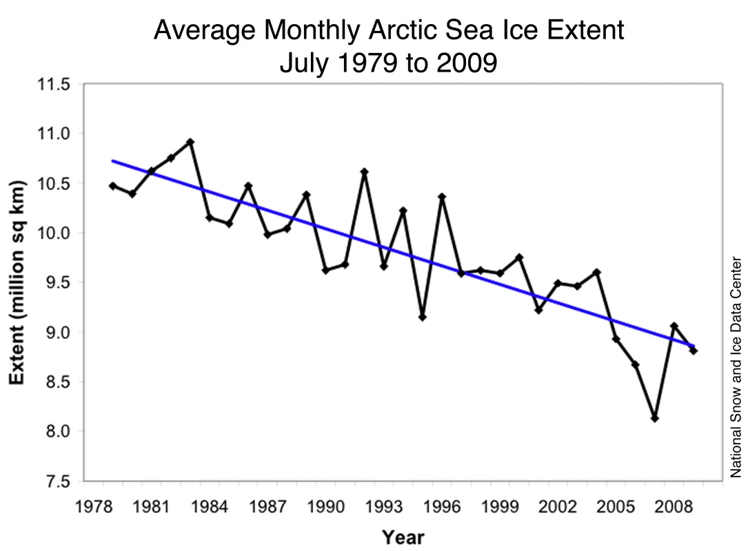
Ice extent averaged for July 2009 was the third lowest in the satellite record for the month of July. The long-term trend indicates a decline of 6.1% per decade in July ice extent since 1979, relative to the 1979 to 2000 average, an average of 62,000 square kilometers (24,000 square miles) of ice per year.
Weather patterns bring clear skies, warmth
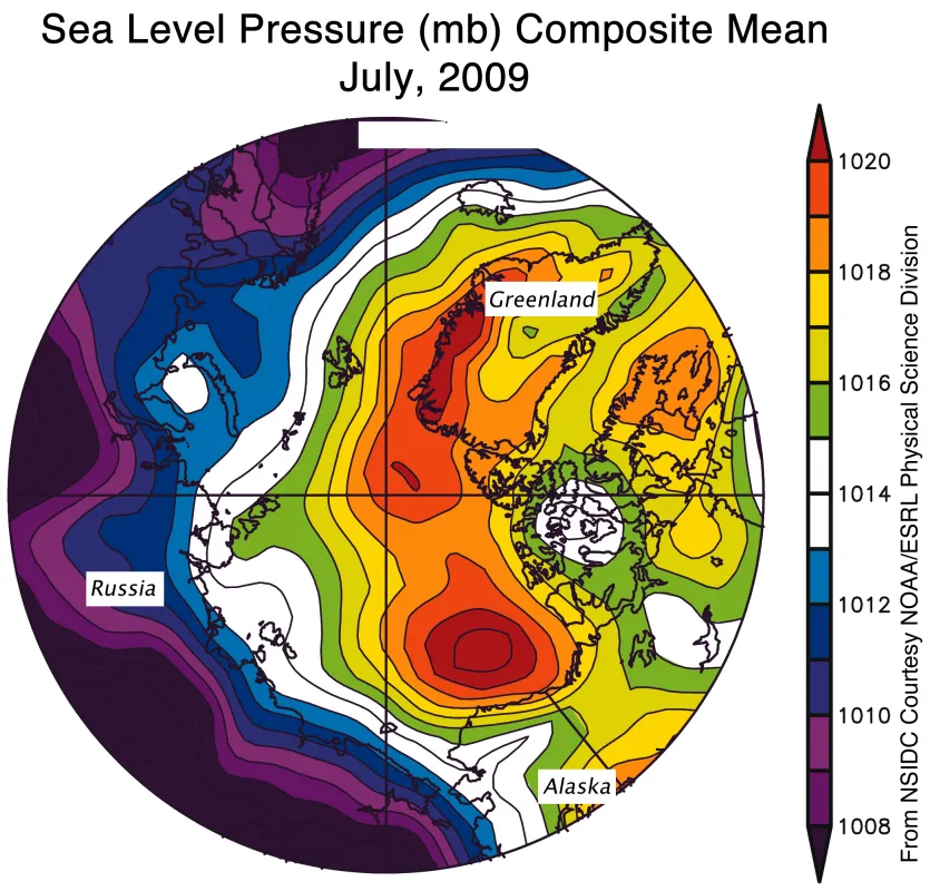
The atmospheric circulation pattern for summer 2009 has been similar to the pattern in summer 2007. As in 2007, an unusually strong high-pressure cell (an anticyclone) settled over the Beaufort Sea, bringing warm air into the Chukchi Sea. This year, the Beaufort Sea anticyclone, averaged for June and July 2009, was even stronger than the anticyclone in 2007. However, unlike 2007, this year the Beaufort Sea high-pressure cell is not paired with unusually low pressure over eastern Siberia, the “dipole” pattern that in 2007 promoted strong surface winds and extreme melt.
The strong Beaufort Sea high-pressure cell that occurred both this summer and in 2007 is part of a larger scale atmospheric pattern known as the Pacific North American (PNA) “teleconnection.” The airflow in the western hemisphere is usually characterized by a low pressure trough over the North Pacific, a ridge over western North America, and a trough over eastern North America. The PNA describes the strength of this pattern. When the PNA is positive, the normal pattern is amplified and the airflow becomes more “wavy” than usual. While the expressions of the PNA vary by season, the strong western North American ridge during the positive PNA favors a strong Beaufort Sea high pressure system. The stronger than usual trough over eastern North America also helps to explain the cool and rainy weather that has gripped this area much of the summer.
Clear skies favor melt in the Beaufort Sea
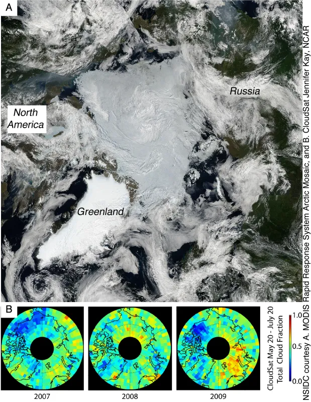
In 2007, unusually sunny skies throughout the summer melt season were one of the factors that helped lead to the record low ice extent. The clear skies allowed more of the sun’s energy to reach the surface, melting the ice and warming the ocean. This year, cloud fields provided by Jennifer Kay at the National Center for Atmospheric Research show fewer clouds over the Beaufort Sea than in 2007, leading to strong melt in that region. However, over the Chukchi and East Siberian Seas, the Arctic sky has been cloudier than 2007.
ReferencesKay, J. E., and A. Gettelman. 2009. Cloud influence on and response to seasonal Arctic sea ice loss. Journal of Geophysical Research, In press, doi:10.1029/2009JD011773.
L’Heureux, M. L., A. Kumar, G. Bell, M. Halpert, and R. Higgins. 2008. Role of the Pacific-North American (PNA) pattern in the 2007 Arctic sea ice decline. Geophys. Res. Lett., 45, L20701, doi:10.1029/2008GL035205.
Wang, J., J. Zhang, E. Watanabe, M. Ikeda, K. Mizobatu, J. E. Walsh, X. Bai, and B. Wu. 2009. Is the dipole anomaly a major driver to record lows in Arctic summer sea ice extent? Geophys. Res. Lett., 36, L05706, doi:10.1029/2008GL036706.
