The National Snow and Ice Data Center (NSIDC) is part of the Cooperative Institute for Research in Environmental Sciences at the University of Colorado Boulder. NSIDC scientists provide Sea Ice Today content, with partial support from NASA.
Sea ice covering the Arctic Ocean melted to its sixth lowest extent this year, while sea ice surrounding the Antarctic continent continued to break winter records, according to scientists at the National Snow and Ice Data Center (NSIDC).
Arctic sea ice cover grows each winter as the sun sets for several months, and shrinks each summer as the sun rises higher in the northern sky. Each year, the Arctic sea ice reaches its minimum extent in September. Summer sea ice extent is important because, among other things, it reflects sunlight, keeping the Arctic region cool and moderating global climate.
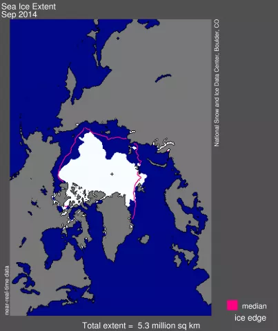
At the end of its melt season, Arctic sea ice fell to the sixth lowest extent in the satellite record, both in the daily and monthly average. Sea ice hit 5.02 million square kilometers (1.94 million square miles) on September 17 and averaged 5.3 million square kilometers (2.05 million square miles) for the month of September.
"Twenty years ago, having ice extent this low would have astounded us," said NSIDC Director Mark Serreze. "Now it is expected."
This year edged out last year as the sixth lowest extent since satellites started measuring sea ice in 1979. The lowest Arctic extent on record occurred in 2012, when sea ice measured 3.41 million square kilometers (1.32 million square miles). The succeeding lowest years are 2007, 2011, 2008, and 2010.
Through 2014, Arctic sea ice has now been declining at a rate of 13.3% per decade relative to the 1981 to 2010 average. The ten lowest September ice extents over the satellite record have all occurred in the last ten years.
“This year was nothing surprising. Overall we’re continuing the long-term decreasing trend,” said Walt Meier, research scientist at the NASA Goddard Space Flight Center. “We’re still well below average and there’s no indication that we’re going to recover.”
Between the seasonal maximum extent that occurred on March 21, 2014 and the September 17 minimum, the Arctic Ocean lost a total of 9.89 million square kilometers (3.82 million square miles) of ice; which is the ninth largest in the satellite record, but the least amount of seasonal loss since 2006. This year’s loss was 1.92 million square kilometers (741,000 square miles) less than the total loss that occurred in 2012.
Weather conditions prevailing over the summer of 2014 were unremarkable. The one significant weather pattern over the summer was a larger than normal pressure gradient over the Laptev Sea that drove southerly winds, brought warmer air and helped drive sea ice northward. This led to the tongue of open water that reached to within 5 degrees latitude of the pole. However, this pressure gradient was not particularly extreme so thinner ice cover in the area was also a significant contributor. Sea surface temperatures may also have played a role.
“The fact that minimum ice extent in 2013 and 2014 still fell so low despite ordinary weather suggests that the system has settled into the low trend,” said NSIDC scientist Julienne Stroeve.
Meanwhile, sea ice surrounding the Antarctic continent reached its maximum extent on September 22 at 20.11 million square kilometers (7.76 million square miles). This is 1.54 million square kilometers (595,000 square miles) above the 1981 to 2010 average extent, which is nearly four standard deviations above average. Antarctic sea ice averaged 20.0 million square kilometers (7.72 million square miles) for the month of September. This new record extent follows consecutive record winter maximum extents in 2012 and 2013. The reasons for this recent rapid growth are not clear. Sea ice in Antarctica has remained at satellite-era record high daily levels for most of 2014.
"What we're learning is, we have more to learn," said Ted Scambos, lead scientist at NSIDC.
The unusual sea ice growth in Antarctica might be caused by changing wind patterns or recent ice sheet melt from warmer, deep ocean water reaching the coastline, according to scientists at NSIDC. The melt water freshens and cools the deep ocean layer, and it contributes to a cold surface layer surrounding Antarctica, creating conditions that favor ice growth.
