An ice shelf is a slab of ice, often hundreds of meters thick, that is attached to a coastline and extends over the adjacent ocean waters. Massive ice shelves hug the perimeter of Antarctica. One of them, the Larsen Ice Shelf, underwent a series of iceberg calvings and, more importantly, ice shelf disintegrations from 1995 to 2002. The breakup events shrank the ice shelf from 86,000 square kilometers (33,000 square miles) to 68,000 square kilometers (26,000 square miles).
The disintegrations followed a series of warm summers when meltwater formed ponds on the shelf. NSIDC Research indicates that the melt ponds played a crucial role in the ice shelf’s collapse.
In the wake of the disintegrations, continued NSIDC research found, glaciers feeding the disintegrated portions of the Larsen Ice Shelf began flowing more rapidly into the ocean, with implications for sea level.
About the Larsen Ice Shelf
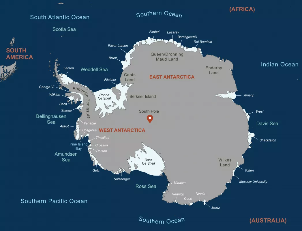
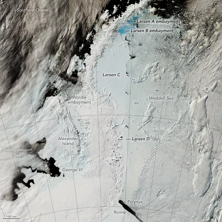
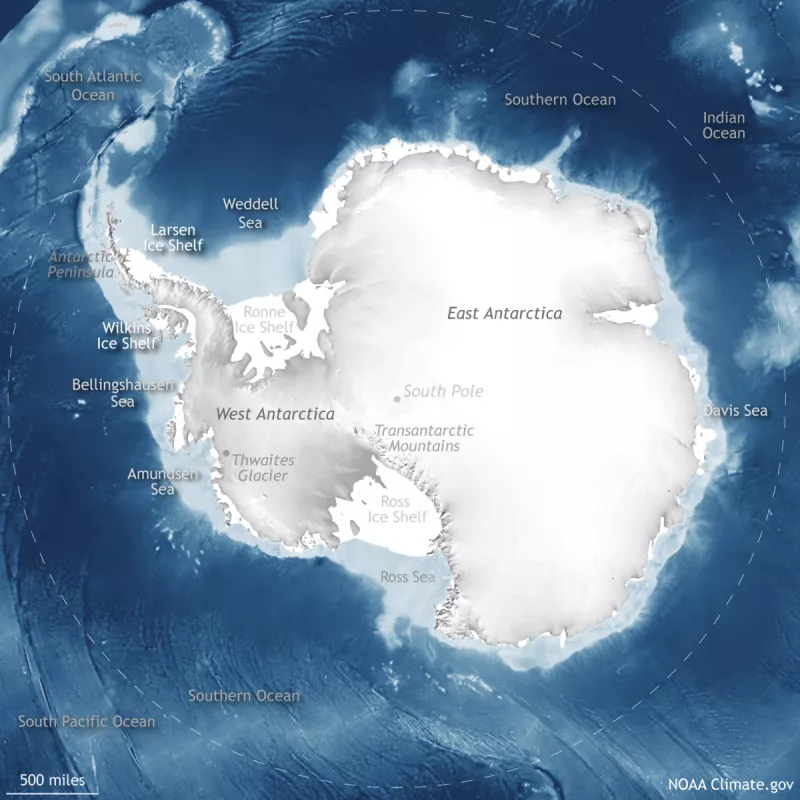
The Larsen Ice Shelf clings to the eastern side of the Antarctic Peninsula and borders the Weddell Sea. Although smaller than the Ronne and Ross Ice Shelves, the Larsen counts among the larger ice shelves on the Antarctic continent.
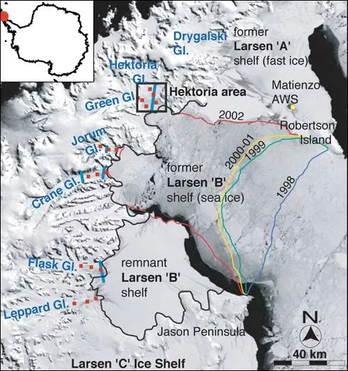
The Larsen Ice Shelf is so long that it has been divided into parts, Larsen A through D, with A being the smallest and C being the largest. Extending from the Antarctic Peninsula’s skinny spine of northward-stretching land, roughly 10 glaciers feed the ice shelf, but glaciers alone do not sustain it. The shelf is also sustained by snow accumulation, especially in the southern parts of the shelf.
Warm weather brings changes
The Antarctic Peninsula has historically been one of the fastest-warming spots on Earth. Between 1950 and 2020, the peninsula warmed by a total of 3 degrees Celsius (5.4 degrees Fahrenheit) overall, although the 2010s brought steady to slightly cooling conditions.
A series of exceptionally warm summers in the 1990s and early 2000s drove a series of ice shelf breakup events on the northern Larsen Ice Shelf. The breakups largely halted in 2006. In some northern shelf areas, fast ice (sea ice welded to the shore) began growing in 2011, but the ice shelf has not returned to its pre-breakup size.
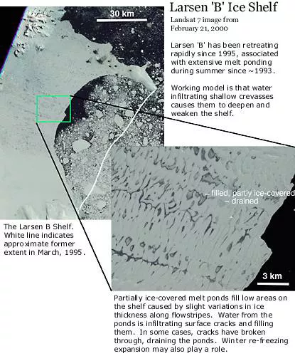
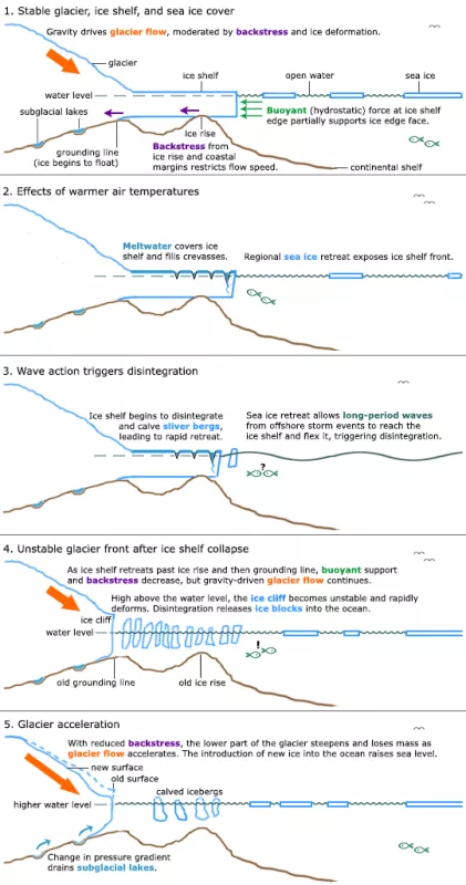
So what caused the dramatic break up? Ice shelves respond rapidly to climate warming because they face multiple pressures in warming conditions. Warm water flowing under an ice shelf can melt the ice from the underside. Sea ice retreat can increase wave action on the front of the shelf, and waves can bend the shelf. A significant factor in ice shelf disintegration is surface melt. Warm summer temperatures cause meltwater to form ponds on the ice shelf surface. These melt ponds can infiltrate preexisting surface cracks and deepen them. Because water is denser than ice, the water deepens the ice cracks. Eventually the water can fracture the shelf. NSIDC researchers have found that all of these factors, melt ponds in particular, contributed to the breakup of the Larsen Ice Shelf.
Larsen Ice Shelf disintegration timeline
January 1995: A large iceberg calves off the Larsen. At the same time, roughly 2,000 square kilometers (770 square miles) of the Larsen A disintegrate.
February 1998 to March 1999: The Larsen B loses over 1,800 square kilometers (700 square miles), retreating past its historical minimum extent.
January 2001: NSIDC Research identifies warm summer surface temperatures and resulting melt ponds as causes of ice shelf disintegration.
January to March 2002: The Larsen B rapidly disintegrates, losing 2,717 square kilometers (1,049 square miles) over 35 days.
See below for more information on each timeline event.
January 1995: Calving and Larsen A disintegration
In late January 1995, a large area, about 2,000 square kilometers (770 square miles) of the Larsen A Ice Shelf, disintegrates into small icebergs, battered by waves during a storm. The disintegration follows a period of regional warming over the previous few decades, and extreme surface melting during several consecutive warm summer seasons in the 1990s.
At the same time, farther south, a large iceberg 70 kilometers by 25 kilometers (43 miles by 16 miles) calves from the shelf. Although the large iceberg receives popular media coverage, it is simply part of the normal mass balance cycle.
February 1998 to March 1999: Larsen B historic retreat
Between February 1998 and March 1999, the Larsen B Ice Shelf loses over 1,800 square kilometers (700 square miles). By late March 1998, the Larsen B recedes past its historical minimum extent. No one has observed such an extensive retreat on the Larsen Ice Shelf before. The ice shelf retreat appears closely associated with melt pond formation in warm summer seasons.
Researchers studying the Larsen see a further cause for concern. As an ice shelf retreats farther inland, the remaining ice cliff grows taller, towering higher above the water surface. Models suggest that the higher the ice cliff looms over the ocean water, the more unstable the ice cliff becomes, just as a tall tower of toy blocks is more likely to topple than a short tower.
January 2001: Warm summers identified as the cause of ice shelf collapse
NSIDC researchers, having observed retreats of the Larsen Ice Shelf in 1995 and 1998, publish an analysis of the causes of ice shelf retreat, citing the key role played by melt ponds formed during warm summers.
January to March 2002: Rapid disintegration of the Larsen B
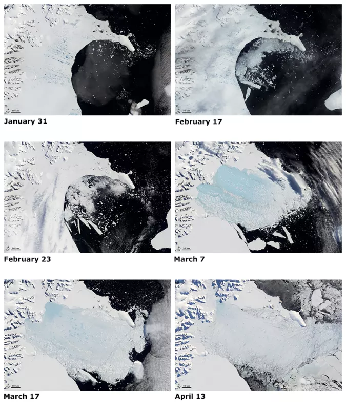
Beginning on January 31, 2002, the Larsen B enters a period of rapid, dramatic collapse. Between January 31 and March 7, the shelf loses 2,717 square kilometers (1,049 square miles). Following this period of dramatic decline, the shelf continues shedding ice at a somewhat slower pace through mid-April.
The Moderate Resolution Imaging Spectroradiometer (MODIS) on NASA's Terra satellite observes the collapse of the shelf. Sequential images from the MODIS sensor show extensive melt pond formation over the Larsen B in late January, consistent with an unusually warm summer and extended melt season. In images taken in February, several of the melt ponds have disappeared, presumably as they have drained through opening fractures in the ice. The area lost by the shelf is almost solely the region covered by melt ponds in late January.
The area lost is larger than the state of Rhode Island. In terms of weight, the amount of ice lost by early March 2002 is 720 billion tons. The shelf continues losing ice in the following weeks, the losses apparently ending by April 13, 2002.
Larsen Ice Shelf losses over the previous five years, culminating in this rapid disintegration event, leave the Larsen B at roughly 40 percent the size of its previous minimum stable extent. The collapse in early 2002 is the largest single event in a series of retreats over the past 30 years.
After the shelf collapse: Glacier acceleration
In the wake of the two large disintegrations, in January 1995 and March 2002, glaciers feeding those areas of the Larsen Ice Shelf began flowing more rapidly toward the ocean. An international team, including NSIDC staff, published research linking disintegration of the Larsen B Ice Shelf to the observed glacier acceleration. Their research found that the glaciers began flowing anywhere from two to six times faster after the ice shelf disintegrated than before disintegration.
The impact of ice shelves on glaciers
Although some ice shelves are formed entirely by sea ice, most big ice shelves, as is the case in Antarctica, are fed by glaciers. In stable glacier-ice shelf systems, the ice shelves act as buttresses, or braking systems, for their tributary glaciers. The shelves also keep warmer marine air at a distance from the glaciers, moderating the amount of melting that occurs on the glaciers' surfaces. Sea ice cover can also play a stabilizing role for an ice shelf, by limiting the amount of wave action that would otherwise flex the shelf.
Warmer conditions can destabilize the system, with long-term effects.
Once their ice shelves are removed, the glaciers flow faster due to meltwater percolation and/or a reduction of braking forces. When the ice retreats past the grounding line (where glacier ice begins to float on ocean water), the glacier feeding the shelf will likely accelerate and thin rapidly. The glaciers may begin to dump more ice into the ocean than they gather as snow.
Glacier acceleration observed
In September 2004, research linked the Larsen Ice Shelf disintegration to glacier acceleration on the Antarctic Peninsula.
Removal of the ice shelf causes dramatic glacier acceleration by reducing two forces that counteract glacier flow. One counteracting force is "backstress" produced by islands or coastline underlying the original shelf. Another is the buoyant (hydrostatic) force of the seawater against the front of the shelf or glacier.
Of the glaciers feeding the Larsen Ice Shelf, the Hektoria Glacier showed especially pronounced acceleration and thinning.
Hektoria Glacier acceleration timeline
January 27, 2000: The Hektoria Glacier system is stable, but increased summer melting from climate warming in the 1980s and 1990s has affected the glacier system in two ways: (1) a seasonal speedup from summer melt water percolating through the glacier ice to its base, and (2) initial retreat of the Larsen Ice Shelf caused by the effects of melt ponds.
April 6, 2002: Record-high temperatures and melting in the austral summer earlier this year have caused significant glacier acceleration. While the March 2002 Larsen Ice Shelf disintegration has likely resulted from rapid local climate warming, sea level is not affected by the breakup of ice that is already afloat.
December 18, 2002: As ice shelf retreat continues past the grounding line, the lower portion of the glacier accelerates rapidly. Thousands of new crevasses form in the glacier trunk because of major changes in the forces ("backstresses") acting on the glacier. These changes occur during the Antarctic winter, so they are not related to melt percolation.
February 20, 2003: As the glacier acceleration continues and propagates upstream, the lower portion of the glacier loses tens of meters in elevation. The mass of ice delivered to the ocean increases, contributing to a rise in sea level.
The potential impact of ice shelf loss on sea level
An ice shelf disintegration, even one that occurs rapidly, does not directly raise sea level because the ice is already floating and displacing its own volume in the ocean water. But when glaciers feeding an ice shelf accelerate, the increased glacier flow adds to global sea level. Essentially, land ice begins moving into the water.
While the breakup of the ice shelves on the Antarctic Peninsula has little consequence for sea level rise, the breakup of other shelves in the Antarctic could have a major effect on the rate of ice flow off the continent. The Ross Ice Shelf, for example, is the main outlet for several major glaciers draining the West Antarctic Ice Sheet, which contains the equivalent of 5 meters (16 feet) of sea level rise in its above-sea-level ice.
Ted Scambos of the University of Colorado Boulder said, "The process can be expected to be more widespread if Antarctic summer temperatures continue to increase. The shelf retreats that have occurred so far have had few consequences for sea level rise, but breakups in some other areas like the Ross Ice Shelf could lead to increases in ice flow off the Antarctic Ice Sheet and cause sea level to rise."
References
Scambos, T.A. C. Hulbe, M. Fahnestock, and J. Bohlander. 2000. The link between climate warming and break-up of ice shelves in the Antarctic Peninsula. Journal of Glaciology, 46(154), 516-530. https://doi.org/10.3189/172756500781833043
Scambos, T.A., J.A. Bohlander, C.A. Shuman, P. Skvarca. 2004. Glacier acceleration and thinning after ice shelf collapse in the Larsen B embayment, Antarctica. Geophysical Research Letters, 31, L18402. https://doi.org/10.1029/2004gl020670
