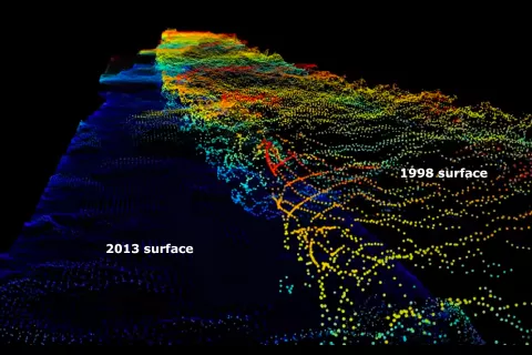
NSIDC has updated two key data sets from NASA's Airborne Topographic Mapper (ATM) sensor, expanding the range of these data sets from 1993 to 2018. ATM observations count among the few ice-surface-height observations collected in the early 1990s, and the recent update provides a 25-year record of continual observations from the same source over some of Earth's fastest-changing regions.
Changes in polar ice have global implications. As sunlight-reflecting ice bodies shrink, our planet absorbs more solar energy. As glaciers melt, ocean levels rise. One way to monitor changing ice conditions is to observe changes in surface elevation because ice bodies shedding mass lose elevation over time.
NASA's ATM laser altimeters measure ice surface heights across North America, Greenland, the Arctic, and Antarctica. ATM takes measurements by bouncing lasers off ice surfaces, and measuring the time those lasers take to return to the aircraft. ATM can assess the topography within as little as 4 inches.
NSIDC Project Manager Steve Tanner says, "Earth's frozen places are changing. I've visited a few of the glaciers that ATM has measured. Seeing the glacier heights drop, and seeing those glaciers retreat year after year has given me a vivid picture of how quickly the change is happening."
The aircraft fly about 1,000 to 2,000 feet above ground, and ATM lasers follow tight tracks. "The data sets look like Greenland glaciers wrapped in technicolor beads," Tanner says. "But we can stack these yearly observations on top of each other until we get a complete picture of the glacier's changes. The images are beautiful and stark."
NSIDC's updated data sets include IceBridge ATM L1B Elevation and Return Strength, Version 2 and IceBridge ATM L2 Icessn Elevation, Slope, and Roughness, Version 2. NSIDC also offers a complete listing of Operation IceBridge aircraft missions. You can find an introduction to ATM on the NASA site.
