Since 2007, the Arctic sea ice minimum has dropped below 5 million square kilometers (1.93 million square miles) every year, except in 2009, 2013, and 2014, when extent barely crossed the 5 million square kilometer mark. Such low extents would have been hard to imagine in the 1990s, when extent averaged 6.46 million square kilometers (2.49 million square miles). This persistent new normal, and the related losses of most of the old and thick ice, are prominent characteristics of the new, warmer Arctic—resiliently low in ice cover despite more than a decade of variations in seasonal climate patterns and ocean conditions. Arctic climate warming continues to lead an unfortunate path of change for the planet. Here, NSIDC researchers summarize this year’s events in the Arctic, and touch upon Antarctica sea ice extent at the end of its austral winter.
Overview of conditions
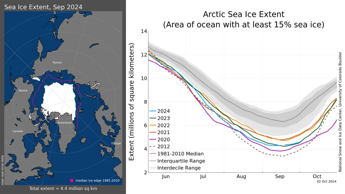
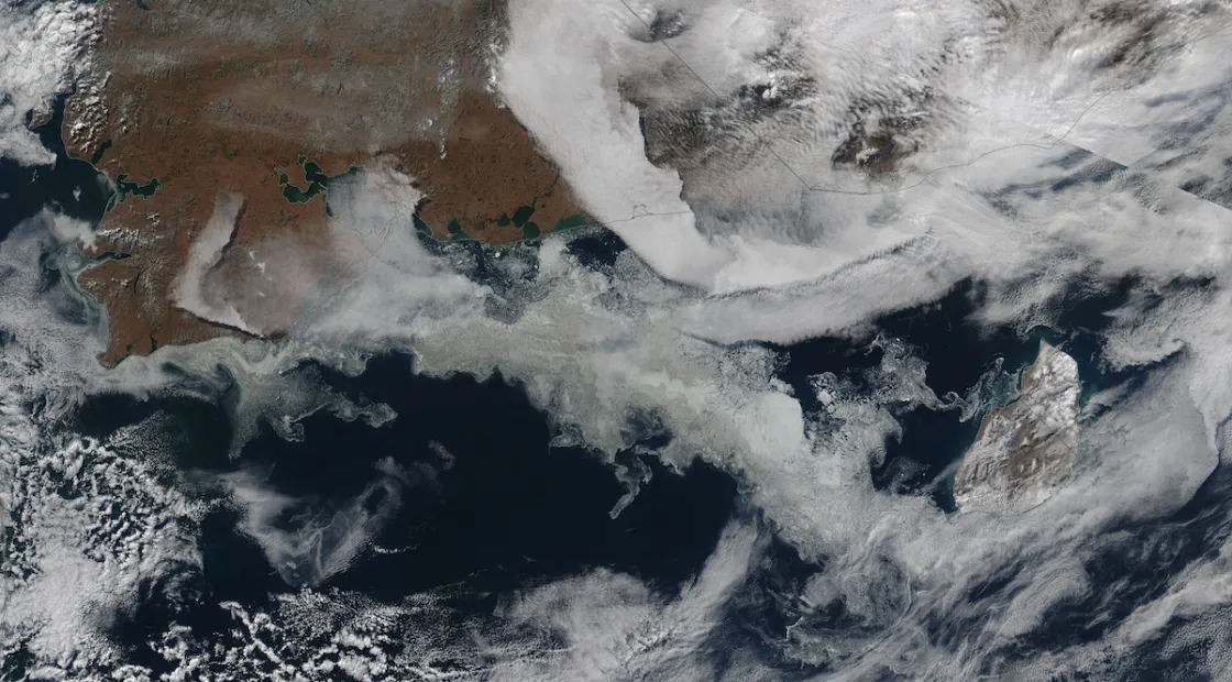
Average Arctic sea ice extent for the month of September was 4.38 million square kilometers (1.69 million square miles), sixth lowest in the 46-year-satellite passive microwave record (Figure 1a). Ice extent was particularly low in the Beaufort Sea and the Kara and East Siberian Seas. A unique feature of this year was the region of compact, first-year ice along far northeastern Russia, near Wrangel Island that survived the melt season. This ice is “dirty” and appears to have been transported from the continental shelves of the Laptev Sea. Sea ice in the Northwest Passages (NWP) through the channels of the Canadian Archipelago dropped rapidly through September, despite an influx of ice from the north. Both NWP routes and the Northern Sea Route along the Russian coast are presently clear of ice via satellite imagery—with the exception of the coastal area near Wrangel Island.
The rate of change of Arctic sea ice extent in September was relatively low at the beginning of the month with an approximate 24,000 square kilometers (9,000 square miles) per day loss through September 10 (Figure 1b). The rate of growth following the minimum was also low at 14,000 square kilometers (5,000 square miles) per day between September 12 and September 30.
Conditions in Context
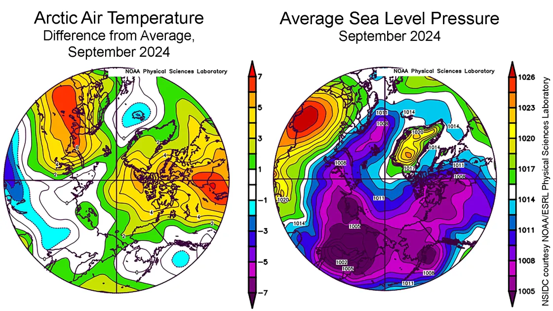
Air temperatures at the 925 hPa level (approximately 2,500 feet above the surface) were 2 to 3 to degrees Celsius (4 to 5 degrees Fahrenheit) above average over the eastern Beaufort Sea, Canadian Archipelago, and Greenland, and reached 5 degrees Celsius (9 degrees Fahrenheit) above average in northern Baffin Bay and northern Greenland (Figure 2a). Conditions were also quite warm over the Barents Sea with temperatures 2 to 5 degrees Celsius above average (4 to 9 degrees Fahrenheit) and up to 6 degrees Celsius (11 degrees Fahrenheit) above average in westernmost Russia near Finland.
The atmospheric pattern for the month at sea level was dominated by strong high pressure over western Russia that brought warm air northward to Eastern Europe and the Barents Sea (Figure 2b). Relatively high pressure over Greenland and Baffin Bay also drove warm winds northward into the Canadian Archipelago, supporting the rapid loss of sea ice in the Northwest Passage region. Lower air pressure (near 1,000 millibars) was the rule over a wide area from Alaska to eastern Russia.
September 2024 compared to previous years
Including 2024, the downward linear trend in Arctic sea ice extent for September is 78,000 square kilometers (30,000 square miles) per year, or 12.13 percent per decade relative to the 1981 to 2010 average. Based on the linear trend, since 1979, September has lost 1.61 million square kilometers (622,000 square miles) of sea ice, which is roughly equivalent to the state of Alaska or the country of Iran.
Wrangel Island sea ice feature
A unique feature in the Arctic sea ice this summer was durable, compacted, and apparently sediment-laden, first-year ice that persisted between the far northeastern Siberian coast and Wrangel Island. This feature, apparent in June, persisted through the entire melt season. It appears to have formed from strong motion of first-year ice from the east and south that compacted and ridged the ice, as well as scouring and upturning sediment. The thickness of the ice prevented it from melting completely even though the rest of the surrounding ice pack melted back several hundred kilometers. The sediment gave the ice surface an unusual brownish-gray tint.
Northwest Passage
Our colleague Steven Howell provided an update on the late-season conditions and causes of low ice cover in the Northwest Passage (NWP). As of October 1, 2024, sea ice area in the northern (deepwater) route was at an all-time record low extent, besting the previous record low that occurred on September 17, 2011 (Figure 5a). At the beginning of September, there was southward ice advection through channels between the northern islands of the Canadian Archipelago from higher latitude regions, as indicated by the up-tick of sea ice area in the NWP tracking area on September 10. However, wind patterns changed mid-September, limiting southward advection, and bringing in warmer air. Melting from the combined effects of ocean and air resulted in the northern route being virtually sea ice free by late in the month (Figure 5b). The southern route is also sea ice free, a more typical occurrence in recent Septembers.
Arctic sea ice continues to be young and thin
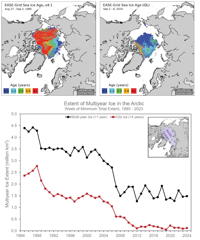
One characteristic of the “new abnormal Arctic” is a lack of multiyear ice, particularly the oldest and generally thickest ice (greater than four-years old). Multiyear ice was once the dominant sea ice type in the Arctic Ocean (Figure 6). At the end of summer in the mid-1980s, there was over 4 million square kilometers (1.54 million square miles) of multiyear ice and over 2 million square kilometers (772,000 square miles) of ice greater than four-years old. At the end of the 2024 melt season, there was only 1.48 million square kilometers (571,000 square miles) of multiyear ice and only 120,000 square kilometers (46,000 square miles) of ice greater than four-years old. Phrased differently, the Arctic Ocean has lost 95 percent of its oldest and thickest ice.
Another strange year for Antarctic sea ice
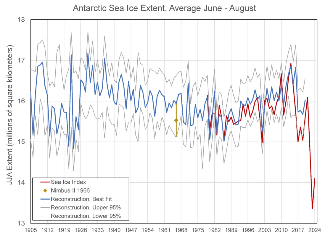
Antarctic sea ice continued to track at exceptionally low extent levels for late winter, and appears to have reached its maximum on September 19 at 17.16 million square kilometers (6.63 million square miles). Averaged for September, sea ice extent stood at 17.06 million square kilometers (6.59 million square miles), just 260,000 square kilometers (100,000 square miles) above last year’s record-setting low monthly average. The last two years have had lower maximum extents than any other years in the modern satellite record by nearly 1 million square kilometers (386,000 square miles). Extent for the past two years has fallen well below levels before the modern satellite era, based on estimates derived from climate indices (Fogt et al., 2022), as well as an estimate for 1966 based on early visible-band, satellite imagery from Nimbus-II.
Review of the Arctic’s seasonal retreat in 2024
Starting from a relatively high winter peak as the fourteenth lowest extent, Arctic sea ice remained higher than the previous 12 years until July, when the rate of decline accelerated, pushing ice extent to third lowest by late July. However, in early September, the rate of loss slowed, and the daily minimum finished at seventh lowest in the 46-year-satellite record. Because of slow ice growth after the daily minimum, the September average extent was the sixth lowest. Key aspects of the 2024 decline were an early loss of ice in eastern Hudson Bay, driven by unusually strong winds from the east that pushed the ice towards the west. This was followed by a rapid loss of ice along the Siberian coast in July as winds and warm conditions opened much of the Kara and Laptev Seas. In August, losses in the Beaufort Sea, which had lagged in the beginning of the melt season, began to dominate the rate of retreat. As already discussed, an unusual area of compact, first-year ice persisted near Wrangel Island.
Overall, the Arctic climate of the summer of 2024 (June through September) was characterized by a fairly strong Icelandic low. Owing to slack winds, ice transport in the Transpolar Drift Stream was relatively slow. Air temperatures at the 925 hb level over the same period were high in the Barents Sea at 4 degrees Celsius (7 degrees Fahrenheit) above average and Hudson Bay at 3 degrees Celsius (5 degrees Fahrenheit), but notably below average in the vicinity of northeastern-most Siberia and Wrangel Island. Overall, the Arctic Ocean was about 1 degree Celsius (2 degrees Fahrenheit) above average for the four warmest months.
Further reading
Fogt, R., M. N. Raphael, and M. S. Handcock. 2023. Seasonal Antarctic Sea Ice Extent Reconstructions, 1905-2020, Version 1 [Data Set]. Boulder, Colorado USA. National Snow and Ice Data Center, doi:10.7265/55×7-we68. Date Accessed 10-02-2024.
Gallaher, D., G. G. Campbell, W. N. Meier. 2014. Anomalous variability in Antarctic sea ice extents during the 1960s with the use of Nimbus data. IEEE Journal of Selected Topics in Applied Earth Observations and Remote Sensing, 3(7), 881-887, doi:10.1109/JSTARS.2013.2264391.
Tschudi, M., W. N. Meier, J. S. Stewart, C. Fowler, and J. Maslanik. 2019a. EASE-Grid Sea Ice Age, Version 4 [Data Set]. Boulder, Colorado USA. NASA National Snow and Ice Data Center Distributed Active Archive Center, doi:10.5067/UTAV7490FEPB. Date Accessed 10-02-2024.
Tschudi, M., W. N. Meier, and J. S. Stewart. 2019b. Quicklook Arctic Weekly EASE-Grid Sea Ice Age, Version 1 [Data Set]. Boulder, Colorado USA. NASA National Snow and Ice Data Center Distributed Active Archive Center, doi:10.5067/2XXGZY3DUGNQ. Date Accessed 10-02-2024.
