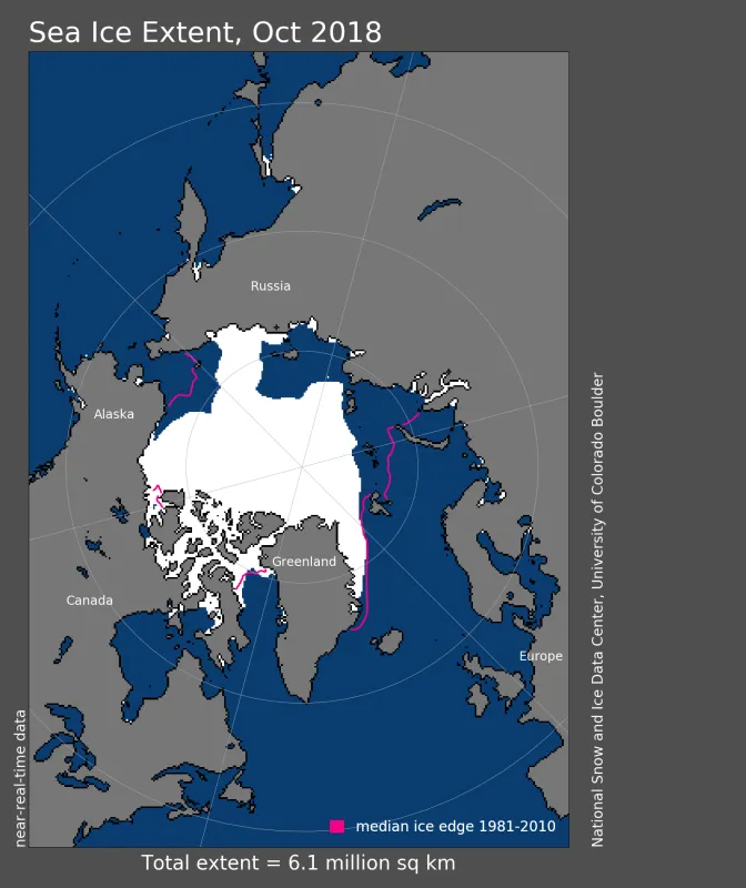
Over the Pacific side of the Arctic, a pattern of unusual warmth noted in last month’s post continued. While sea ice extent in the Chukchi and Beaufort Seas remains below average, extent remains especially low on the Atlantic side of the Arctic in the Barents and Laptev Seas. October sea ice extent in the Arctic was the third lowest in the satellite record.
Overview of conditions
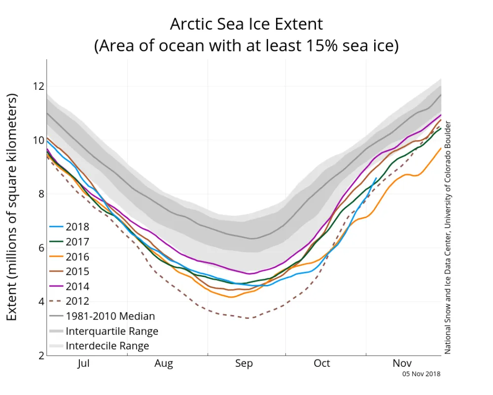
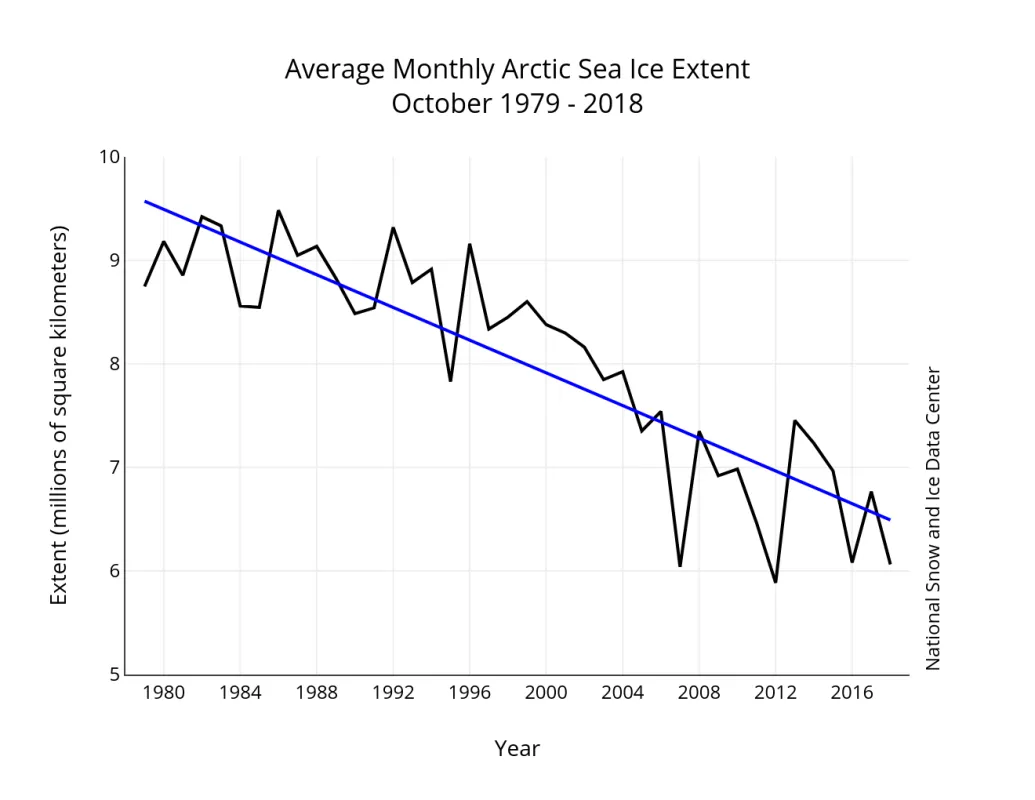
Arctic sea ice extent for October 2018 averaged 6.06 million square kilometers (2.34 million square miles), the third lowest October extent in the 1979 to 2018 satellite record. This was 2.29 million square kilometers (884,000 square miles) below the 1981 to 2010 average, and 170,000 square kilometers (66,000 square miles) above the record low recorded for October 2012.
Sea ice gain during the first half of the month was quite slow. By the third week of October, extent was still tracking below all years except 2016. However, toward the end of the month, the pace of ice growth increased.
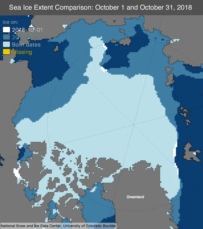
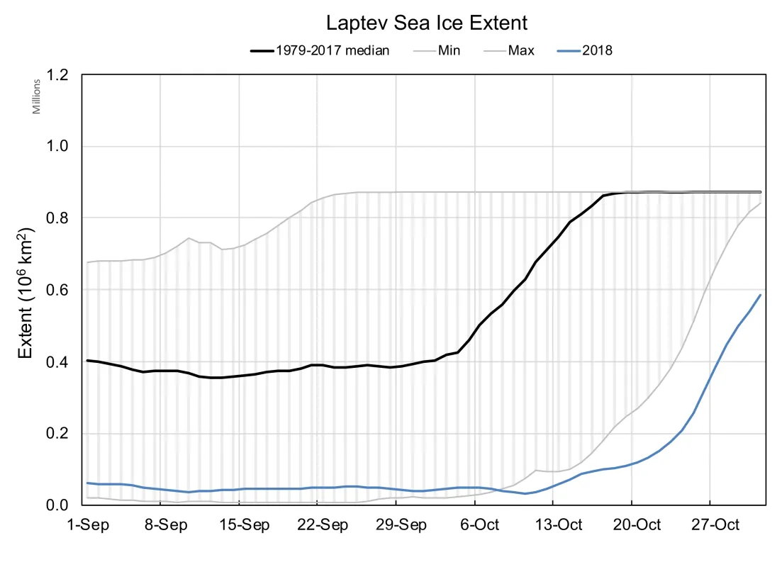
Ice growth through the month was strong in the Beaufort and Chukchi Seas, but extent remained below average in these areas at the end of the month. A large area of open water remained in the Laptev Sea, which is unprecedented in the satellite record at the end of October. Especially prominent was the lack of ice growth on the Atlantic side of the Arctic in the Barents Sea, and in some regions, a slight contraction of the ice edge further north (Figure 1b). As a result, extent is presently far below average in this area, and is the primary reason why October extent for the Arctic as a whole is third lowest on record.
Conditions in context
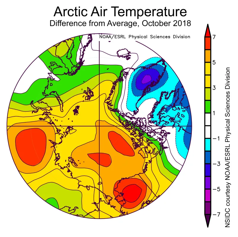
October air temperatures at the 925 hPa level (about 2,500 feet above the surface) were above average across nearly all of the Arctic Ocean, but especially high temperatures—5 to 7 degrees Celsius (9 to 13 degrees Fahrenheit) above average—were found over the Beaufort and Chukchi Seas and extending poleward. The most extreme warmth was located over central Alaska, where temperatures were up to 7 degrees Celsius (13 degrees Fahrenheit) higher than average (Figure 2b).
A high-pressure ridge at 500 hPa over Alaska persisted through the month, extending onto the Chukchi and Beaufort Seas. This temperature pattern is broadly similar to that recorded for September. Below average sea ice extent over the Beaufort and Chukchi Seas is consistent with this unusual warmth. While the temperature pattern appears to be largely driven by the atmospheric circulation pattern, heat loss from the upper ocean to the lower atmosphere during ice formation likely contributed.
Why extent remains so low in the Barents Sea is not immediately clear from patterns of atmospheric circulation and temperature. October air temperatures at the 925 hPa level were only 1 to 3 degrees Celsius (2 to 5 degrees Fahrenheit) above average, associated with a trough of low pressure at sea level extending from Iceland into the region. While further investigation is warranted, this lack of ice growth may relate to the observed “Atlantification” of the Barents Sea, in which the cold, low density surface layer of the Arctic Ocean has weakened, allowing the heat from the warm Atlantic waters to more readily inhibit ice formation. It will be instructive to monitor ice growth rates in this area through the coming winter.
October 2018 compared to previous years
Sea ice extent for October 2018 fell below the long-term linear trend line. The linear rate of sea ice decline for October is 79,000 square kilometers (31,000 square miles) per year, or 9.5 percent per decade relative to the 1981 to 2010 average.
Laptev lacking ice
Another notable feature in the Arctic ice pack at the end of October was the significant amount of open water in the Laptev Sea. Even in 2007 and 2012, the previous record low minimum extent years, the Laptev had nearly completely frozen over by the end of October. As late as October 29, the Laptev sea ice extent was less than 500,000 square kilometers (193,000 square miles). The 1981 to 2010 average extent on that date is 870,000 square kilometers (336,000 square miles)—essentially the entirety of the defined Laptev Sea region. By mid-October, the long-term average sea ice extent exceeds 800,000 square kilometers (309,000 square miles). This year, the mid-October sea ice extent within the Laptev Sea was barely above 100,000 square kilometers (39,000 square miles), about 13 percent of average.
The cause of this lack of ice is multifaceted. Ocean heat gained during the summer is likely delaying freeze-up. As noted above, air temperatures were above average over the region. This may in part be a result of the ocean heat, though low pressure centered over the Barents and Kara Seas also brought in warm air and winds from the south, keeping the ice edge from advancing.
Antarctic sea ice
As noted in the previous post, Antarctica’s annual maximum sea ice extent of 18.15 million square kilometers (7.01 million square miles) was reached on October 2, the fourth lowest maximum in the satellite record.
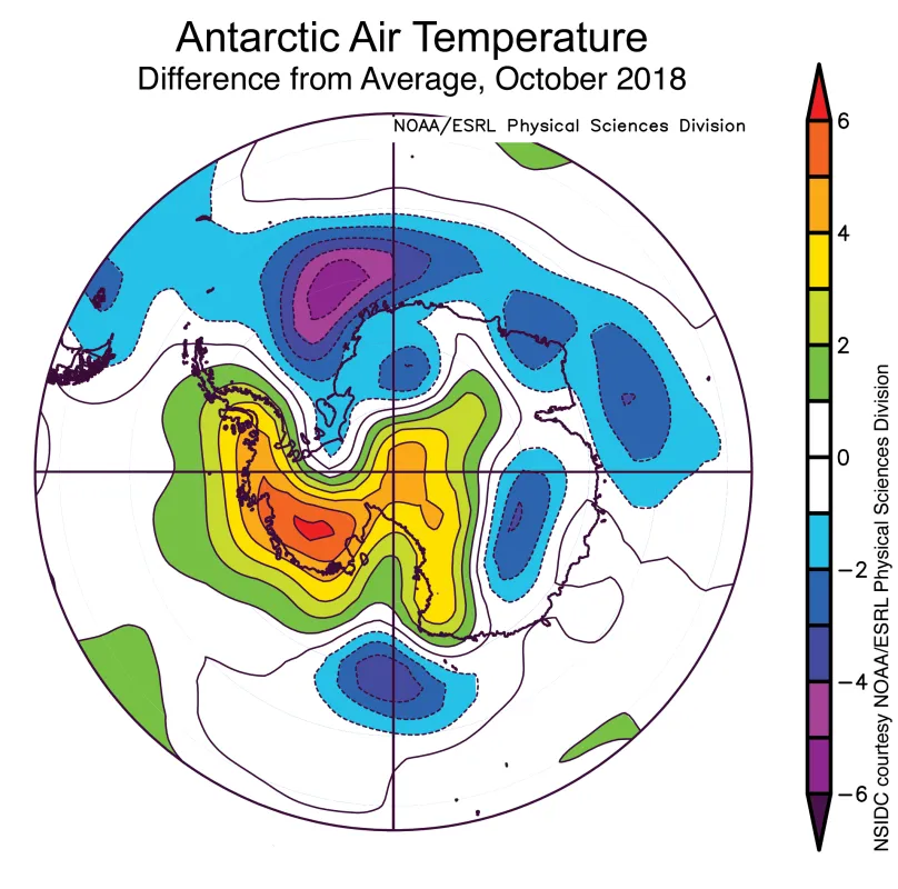
Antarctic sea ice extent for October 2018 averaged 17.66 million square kilometers (6.82 million square miles), also the fourth lowest in the satellite record. Sea ice extent was particularly low in the sector south of Australia, south of Africa, and in the Bellingshausen and Amundsen Seas. Locations and sizes of these regional features varied through the course of the month as storms and strong winds shifted. Air temperatures at 925 hPa were 3 to 6 degrees Celsius (5 to 11 degrees Fahrenheit) above the 1981 to 2010 average in West Antarctica and the southern Antarctic Peninsula, and 2 to 3 degrees Celsius (4 to 5 degrees Fahrenheit) above average over a wide part of the Bellingshausen and Amundsen Seas. However, temperatures in the Weddell Sea region were 2 to 6 degrees (4 to 11 degrees Fahrenheit) below average.
