Images of Antarctic Ice Shelves
West Ross Ice Shelf
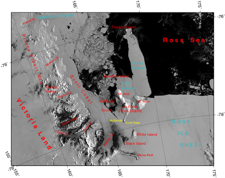
Location Map: MODIS image from 27 January 2003, 19:10
To download a grid/placename overlay like the one in the above image, click here.
Select another ice shelf
Projection Information
Projection: Polar Stereographic
Datum: WGS84
Standard Parallel: -71.0
Corner Coordinates (MODIS):
UL: 74.499841S 158.003895E
LL: 78.283990S 150.213388E
UR: 75.611646S 178.532134W
LR: 79.816828S 177.920485W
Corner Coordinates (AVHRR):
UL: 76.054024S 161.146149E
LL: 79.749214S 153.857178E
UR: 76.795753S 179.968185E
LR: 80.793304S 179.954269E
Number of Rows (MODIS): 1850
Number of Columns (MODIS): 2700
Number of Rows (AVHRR): 549
Number of Columns (AVHRR): 617
Meters per Pixel (MODIS): 250
Meters per Pixel (AVHRR): 800
Note: The MODIS image information above is for images dated 26 February 2005 to present. MODIS PNG and JPEG images before 26 February 2005 have the following coordinates:
Number of Rows: 1380
Number of Columns: 1820
Corner Coordinates:
UL: 75.045416S 160.001163E
LL: 77.939188S 154.857428E
UR: 75.906323S 176.124624E
LR: 79.033563S 175.007415E

