By Jane Beitler
The NASA Operation IceBridge mission ensures continuous scientific observations over Earth’s polar regions during a period of unprecedented change. The mission collects airborne remote sensing measurements to bridge the gap between the NASA Ice, Cloud and Land Elevation Satellite (ICESat), which stopped collecting data in 2009, and the upcoming ICESat-2 mission planned for 2016.
ICESat carried the Geoscience Laser Altimeter System (GLAS) instrument, which was unique in its ability to measure the elevation of ice sheets, ice shelves, and glaciers, compared to other satellites that only detect surface extent. These elevation measurements help researchers assess mass changes in the ice, an indicator of climate change as well as of the potential for sea level rise as water is unlocked from glaciers and ice sheets and added to the oceans. The data produced by IceBridge are just as complex as they are critical. As the data archive and distribution point for IceBridge, NSIDC is addressing the unique challenges of managing data for an extended airborne campaign and getting these data into the hands of researchers studying the polar regions. The recent update of the IceBridge Data Portal at NSIDC is designed to speed that access.
IceBridge data at NSIDC
To date, NSIDC has published 47 unique data sets. Many more data sets are expected as annual campaigns wrap up and submit their data. IceBridge mission observations and measurements include coastal Greenland, coastal Antarctica, the Antarctic Peninsula, interior Antarctica, the southeast Alaskan glaciers, and Antarctic and Arctic sea ice. These data were acquired by 30 separate instruments during 12 flight campaigns, which is one reason that IceBridge data are more complex to manage and access than satellite data.
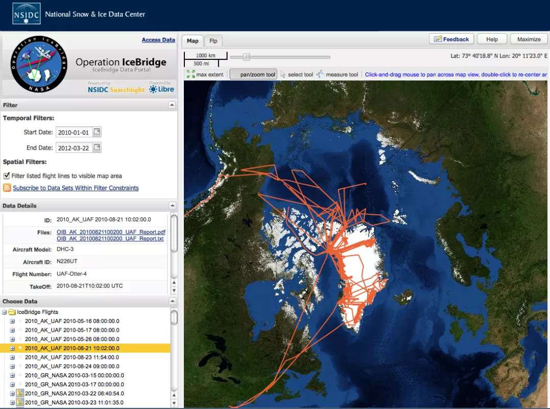
IceBridge combines multiple instruments to map ice surface topography, bedrock topography beneath the ice sheets, grounding line position, ice and snow thickness, and sea ice distribution and freeboard. Data from laser altimeters and radar sounders are paired with gravimeter, magnetometer, digital camera, and other data to provide dynamic, high-value, repeat measurements of rapidly changing portions of land and sea ice. Because these measurements follow a complex web of flight lines rather than the large, consistent swaths of satellite-borne instruments, researchers need a way to discover what data exist for a study region. NSIDC is building the IceBridge Data Portal to help researchers more quickly locate and access data, using a map-based interface.
The IceBridge Data Portal
The IceBridge Data Portal is a Web-based tool for quickly and easily finding flight reports and science data for a selected flight. A map display helps users visualize where the actual flights took place. The interface provides three panels with information and controls to display flight reports, instrument data, and related data sets. In the Filter panel, users can filter flight reports by temporal coverage using a calendar, and filter flight reports by spatial coverage by drawing a bounding box on the map display. Flight lines appear on the map, showing researchers which flights covered a particular study area. Users can click on a flight line to get more detailed information. The Data Details panel displays metadata about the selected flight report, and a link to either a text file, or a Portable Document Format (PDF) of the flight report. The text file contains a subset of the content in the PDF. The PDF contains more detailed information logged by the flight manager after the flight. Users can also click on a flight report in the Choose Data panel, and that flight line will change to yellow on the map display. They can click on the data set link in the Choose Data panel to access the flight data via FTP. They can also access related NSIDC data sets. In addition, NSIDC is currently preparing to put datasets into permanent archive, where they will have full spatial metadata and more related services. This move will make the data accessible via the NASA Reverb data interface and the NSIDC Data Pool drill down interface, in addition to direct FTP download. Future portal releases will include more sophisticated search and visualization functions necessary to fully exploit the data. These steps are part of the long-term plan to increase visibility and access for IceBridge data.
To learn more about IceBridge data sets, visit the NSIDC IceBridge Data site. To learn more about the IceBridge project, visit the NASA Operation IceBridge home page.
