By Jane Beitler
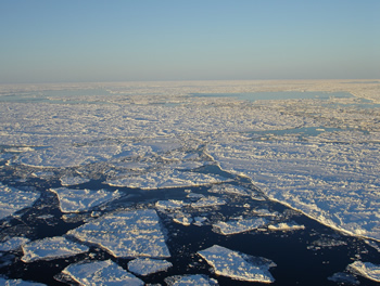
At NSIDC, researchers study Arctic sea ice using data from satellites. But those data just provide one view of the ice cover. Arctic biologists, climate scientists, hunters, and ship captains all use data on sea ice to inform their work. NSIDC data expert Mark Parsons said, “Think about just a simple term like ‘ice edge.’ Different communities define that in different ways.” Researchers who use satellite data define the edge of the sea ice pack as where less than fifteen percent of the surface is covered in ice. Parsons said, “But if you are a ship captain, that’s not going to cut it. You need to know where the ice edge is in terms of risk to your ship.” How can sea ice data from different disciplines be made accessible and usable by a broader audience?
Parsons and a team of researchers from NSIDC and Rensselaer Polytechnic Institute are working to solve that problem with a new project called the Semantic Sea Ice Interoperability Initiative (SSIII). “The whole goal in Arctic science is to try to understand the Arctic as a system,” said Parsons. ”So we need data from very diverse sources.” The SSIII aims to bridge the gaps between those different data types, establishing clear definitions of terms and linking them to other terms in a way that computers can understand and communicate.

The SSIII takes vague terms like “ice edge” and encodes all the different definitions, in a way that computers can comprehend them, to create a framework that organizes concepts and their relationships, called an ontology. The ontology for ice edge would include the ship captain’s definition, the remote sensing definition, as well as any definitions provided by other groups like Inuit hunters, who rely on the ice pack for travel and hunting.
Towards interoperability
Organizing the vocabularies of sea ice into a framework provides a foundation for sharing not just data, but the meaning of the data “This is a baby step towards the greater vision,” said Parsons. “You have precise meanings that are understood by machines, to enable people to use data from different sources.” While the SSIII focuses on sea ice as a model system, Parsons and his colleagues at NSIDC and Rensselaer are part of a growing community of data experts who are working to make data more accessible and useable, as science becomes increasingly interdisciplinary and data sets become larger and more complicated. The project, funded by a grant from the National Science Foundation, has just completed its first of four years.
Acknowledgements
This material is based upon work supported by the National Science Foundation under Grant Number 0956010. Any opinions, findings, and conclusions or recommendations expressed in this material are those of the author(s) and do not necessarily reflect the views of the National Science Foundation.