Arctic sea ice extent for January 2013 was well below average, largely due to extensive open water in the Barents Sea and near Svalbard. The Arctic Oscillation also remained in a primarily negative phase. Antarctic sea ice remained extensive due to an unusual northward excursion of ice in the Weddell Sea. December of 2012 saw Northern Hemisphere snow cover at a record high extent, while January 2013 is the sixth-highest snow cover extent on record since 1967.
Overview of conditions
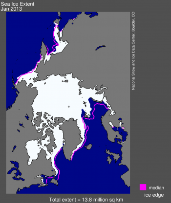
Figure 1. Arctic sea ice extent for January 2013 was 13.78 million square kilometers (5.32 million square miles). The magenta line shows the 1979 to 2000 median extent for that month. The black cross indicates the geographic North Pole. Sea Ice Index data. About the data
Credit: National Snow and Ice Data Center
High-resolution image
The average sea ice extent for January 2013 was 13.78 million square kilometers (5.32 million square miles). This is 1.06 million square kilometers (409,000 square miles) below the 1979 to 2000 average for the month, and is the sixth-lowest January extent in the satellite record. The last ten years (2004 to 2013) have seen the ten lowest January extents in the satellite record.
As has been the case throughout this winter, ice extent in the Atlantic sector of the Arctic Ocean remained far below average. While the Kara Sea was completely iced over, nearly all of the Barents Sea remained ice free, and open water was present north of the Svalbard Archipelago. The lack of winter ice in the Barents Sea and the vicinity of Svalbard has been a common feature of recent years. Recent work by Vladimir Alexeev and colleagues at the University of Alaska Fairbanks provides further evidence that this is related to a stronger inflow of warm waters from the Atlantic as compared to past decades. On the Pacific side, the ice edge in the Bering Sea continued to extend slightly further to the south than usual.
Also, a new paper by Jinlin Zhang and colleagues at the University of Washington analyzed the effect of the strong August 2012 cyclone on last year’s record sea ice minimum. While they found a large effect in the immediate wake of the storm, the effect declined quickly and overall it had only a small effect on the final September minimum extent.
Conditions in context
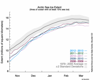
Figure 2. The graph above shows Arctic sea ice extent as of February 4, 2013, along with daily ice extent data for the previous five years. 2012 to 2013 is shown in blue, 2011 to 2012 in green, 2010 to 2011 in pink, 2009 to 2010 in navy, and 2008 to 2009 in purple. The 1979 to 2000 average is in dark gray. The gray area around this average line shows the two standard deviation range of the data. Sea Ice Index data.
Credit: National Snow and Ice Data Center
High-resolution image
Through the month of January, the Arctic gained 1.36 million square kilometers of ice (525,000 square miles), which is slightly higher than average for the month. Air temperatures at the 925 hPa level were 2 to 5 degrees Celsius (4 to 9 degrees Fahrenheit) higher than average across much of the Arctic Ocean. Conditions were especially warmer than average near Svalbard where ice-free conditions persist. Below average temperatures characterized parts of northern Eurasia and northwestern Canada. The dominant feature of the Arctic sea level pressure field for January 2013 was unusually high pressure over the central Arctic Ocean, consistent with a predominantly negative phase of the Arctic Oscillation.
January 2013 compared to previous years
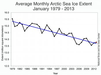
Figure 3. Monthly January ice extent for 1979 to 2013 shows a decline of -3.2% per decade.
Credit: National Snow and Ice Data Center
High-resolution image
Average Arctic sea ice extent for January 2013 was the sixth lowest for the month in the satellite record. Through 2013, the linear rate of decline for January ice extent is -3.2 percent per decade relative to the 1979 to 2000 average.
Looking at Northern Hemisphere snow
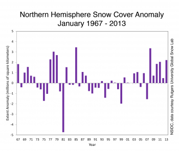
Figure 4. This graphs shows snow cover extent anomaly in the Northern Hemisphere for January from 1967 to 2013. January 2013 is the sixth-highest snow cover extent on record since 1967. The anomaly is relative to the 1971 to 2000 average.
Credit: National Snow and Ice Data Center, data courtesy Rutgers University Global Snow Lab
High-resolution image
As noted in a previous post, Northern Hemisphere snow cover extent for June 2012 set a record low, continuing a downward trend in springtime snow extent. Satellite data from the Rutgers University Global Snow Lab show that after Northern Hemisphere snow cover extent for December 2012 reached a record high for the month of 46.27 million square kilometers (17.86 million square miles), extent during January increased to a monthly average of 48.64 million square kilometers (18.78 million square miles). This was the sixth-highest January extent in the record, dating back to 1967. Snow cover was higher than average throughout much of the western United States as well as northern Europe and eastern China. Snow cover was lower than normal over the central U.S., and much of southern Asia, including the Tibetan Plateau.
A visit to Antarctica
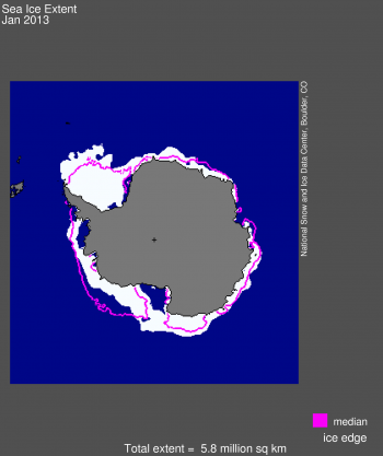
Figure 5. The pattern of Antarctic sea ice extent for January 2013 features an unusual northwards (towards the equator) excursion of sea ice in the northern Weddell Sea. Antarctic sea ice extent as a whole was more than two standard deviations above average for the month. The magenta line shows the 1979 to 2000 median extent for that month. The black cross indicates the South Pole. Sea Ice Index data. About the data
Credit: National Snow and Ice Data Center
High-resolution image
Turning to Antarctica, we note that January 2013 saw an unusual northward (towards the equator) excursion of sea ice in the Weddell Sea. The ice edge was found approximately 200 to 300 kilometers (124 to 186 miles) beyond its typical location. Overall, sea ice extent in the Antarctic was nearly two standard deviations above the mean for most of the month.
The cause of this is very unusual sea ice pattern appears to be persistent high pressure in the region west of the Weddell Sea, across the Antarctic Peninsula to the Bellingshausen Sea. This pressure pattern means that winds are tending to blow to the north on the east side of the Peninsula, both moving the ice northward and bringing in cold air from southern latitudes to reduce surface melting of the ice as it moves north.
Intense Greenland surface melting inspires new Web site
In recent years, the surface of the Greenland Ice Sheet has experienced strong melting, but the 2012 melt season far exceeded all previous years of satellite monitoring, and led to significant amounts of ice loss for the year. NSIDC’s new Web site, Greenland Ice Sheet Today presents images of the widespread surface melt on Greenland during 2012 and scientific commentary on the year’s record-breaking melt extent.
Throughout the coming year, the site will offer daily satellite images of surface melting and periodic analysis by the NSIDC science team. NSIDC scientists at the University of Colorado Boulder developed Greenland Ice Sheet Today with data from Thomas Mote of the University of Georgia, and additional collaboration from Marco Tedesco of the City University of New York.
The Greenland Ice Sheet contains a massive amount of fresh water, which if added to the ocean could raise sea levels enough to flood many coastal areas where people live around the world. The ice sheet normally gains snow during winter and melts some during the summer, but in recent decades its mass has been dwindling.
Further reading
Alexeev, V.A., Ivanov, V.V., Kwok, K., and Smedsrud, L.H. 2013. North Atlantic warming and declining volume of arctic sea ice. The Cryosphere Discussions 7, 245-265, doi: 10.519/tcd-7-245-2013.
Zhang, J., R. Lindsay, A. Schweiger, and M. Steele. 2013. The impact of an intense summer cyclone on 2012 Arctic sea ice retreat. Geophysical Research Letters, In press, doi: 10.1002/grl.50190.

