Sea Ice
Overview
What is sea ice?
Sea ice is frozen seawater that floats on the ocean surface. Bookending our planet, sea ice waxes and wanes with the polar seasons. In the Arctic winter, sea ice stretches its tentacles into seas and coastlines far from the poles. Since land confines most of the Arctic, sea ice can only spread so far southward in many places. By contrast, Antarctic sea ice fringes a massive land mass, growing as far as winter freezing temperatures let it. Come spring, however, sea ice extent shrinks in the Arctic, with a lot of ice persisting, whereas almost all Southern Ocean or Antarctic sea ice is “seasonal ice,” meaning it melts away and reforms annually.
Where is sea ice?
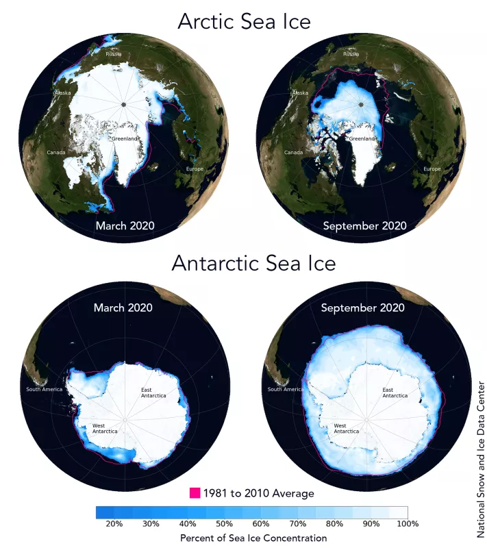
In late winter, Arctic sea ice covers on average* 15.5 million square kilometers (6 million square miles), and Antarctic sea ice covers about 18.5 million square kilometers (7 million square miles). On average, the seasonal decrease is much larger in the Antarctic, with only about 2.5 million square kilometers (1 million square miles) remaining at summer's end, compared to 6.5 million square kilometers (2.5 million square miles) in the Arctic at its summer’s end. However, it is important to note that the Arctic sea ice minimum extent has been consistently below 6.5 million square kilometers (2.5 million square miles) since 2002.
In total, about 34 million square kilometers (13 million square miles) of the world’s oceans (about 9 percent) have sea ice at some point during the year. This is about three times the area of Canada.
However, the amount of sea ice is decreasing. Since 2007, Arctic minima, which typically are reached in September, have been only 3.5 to 5 million square kilometers (1.4 to 1.9 million square miles). This is about a 13-percent-per-decade decrease since the start of the satellite record, which began in 1979.
*based on the 1981 to 2010 reference period
Arctic vs. Antarctic sea ice
Because the Arctic and Antarctic are cold, dark, and remote, we often think these two places are nearly the same. However, there are substantial differences between the two. One notable difference is that polar bears do not live in Antarctica, and penguins do not live in the Arctic. But what about the differences in sea ice between the two regions?
Geographical differences between the poles
Sea ice differs between the Arctic and Antarctic, primarily because of their different geographies. The Arctic is a semi-enclosed ocean, almost completely surrounded by land. As a result, the sea ice that forms in the Arctic is not as mobile as sea ice in the Antarctic. Although sea ice moves around the Arctic basin, it tends to stay in the cold Arctic waters. Pieces of sea ice, known as floes, are more prone to converge, or bump into each other, and pile up into thick ridges. These converging floes make Arctic ice thicker. Since ice tends to stay within the Arctic, it can survive longer and continue to thicken in its cold conditions. The presence of ridge ice and its longer life cycle leads to ice that stays frozen longer during the summer melt. So, a significant proportion of Arctic sea ice remains through the summer and continues to grow the following autumn. Of the 15 million square kilometers (5.8 million square miles) of sea ice that exist during winter, on average, about a third remains at the end of the summer melt season.
The Antarctic is almost a geographic opposite of the Arctic because in Antarctica, an ocean surrounds a land mass. The open ocean around the continent allows the forming sea ice to move more freely, resulting in higher drift speeds. However, Antarctic sea ice forms ridges much less often than sea ice in the Arctic because the open ocean boundary is less constraining. Also, because there is no land boundary to the north, the sea ice is free to float northward into warmer waters where it eventually melts. As a result, almost all the sea ice that forms during the Antarctic winter melts during the summer. During the winter, on average about 18.5 million square kilometers (7.1 million square miles) of ocean is covered by sea ice, but by the end of summer, only about 2.5 million square kilometers (965,000 square miles) of sea ice remain.
Differences in sea ice thickness
Because sea ice does not stay in the Antarctic as long as it does in the Arctic, it does not have the opportunity to grow as thick as sea ice in the Arctic. While thickness varies significantly within both regions, Antarctic sea ice is typically 1 to 2 meters (3 to 6 feet) thick, while Arctic sea ice is typically 2 to 3 meters (6 to 9 feet) thick. In some Arctic regions, ice thickens up to 5 meters (15 feet). However, Arctic sea ice has been thinning with more and more ice measuring only 1 to 2 meters (3 to 6 feet) thick.
Differences in sea ice extent patterns
The pattern of Antarctic maximum sea ice is roughly symmetric around the pole, forming a circle around Antarctica. In contrast, the Arctic is asymmetric, with ice at some longitudes extending to much lower latitudes than at other longitudes. Ocean currents and winds explain these differences.
In the Antarctic, the currents and winds tend to flow without interruption around the continent in a west-to-east direction, acting like a barricade to warmer air and water to the north. In contrast, the Arctic region north of the Atlantic Ocean is open to the warmer waters from the south, because of the way the ocean currents flow. These warmer waters flow into the far northern reaches of the North Atlantic Ocean and into the Arctic Ocean. Even in winter, these waters keep sea ice from forming along the Norwegian coast, even at latitudes north of 70 degrees. The waters off the eastern coasts of Canada and Russia are affected by cold air moving off the land from the west. The eastern Canadian coast is also fed by southward-flowing cold water currents that make it easier for sea ice to grow. Thus, on the eastern Canadian coast, ice extends south of 50 degrees North latitude in winter.
Differences in snow cover
Because ice covers and land surrounds most of the Arctic Ocean, precipitation is relatively small. Snowfall tends to be low, except near the ice edge. Antarctica, however, is entirely surrounded by ocean, so moisture is more readily available. Antarctic sea ice tends to be covered by thicker snow, which may accumulate to the point that the weight of snow pushes the ice below sea level, causing salty ocean water to flood the snow.
Other differences in sea ice
Antarctic sea ice does not reach the South Pole, extending only to about 75 degrees South latitude (in the Ross and Weddell Seas), because of the Antarctic continent. However, Arctic sea ice extends all the way to the North Pole. Here, the Arctic sea ice receives less solar energy at the surface because the sun's rays strike at a more oblique angle, compared to lower latitudes. Because of the Earth’s tilt, the North Pole experiences six months of darkness every year.
Water from the Pacific Ocean and several rivers in Russia and Canada provide fresher, less dense water to the Arctic Ocean. So, the Arctic Ocean has a layer of cold, fresh water near the surface with warmer, saltier water below. By contrast, Antarctica lacks rivers and the open connection to the ocean results in a saltier ocean than the Arctic. The Arctic’s cold, fresh water layer typically allows more ice growth in the Arctic than the Antarctic.
Differences in sea ice extent
Both Arctic and Antarctic sea ice extent are characterized by variations from year to year. The monthly average extent can vary by as more than 1 million or even 2 million square kilometers (386,000 square miles) from the long-term monthly average.
According to scientific measurements, both the thickness and extent of summer sea ice in the Arctic have shown a dramatic decline over the past 30 years. This is consistent with observations of a warming Arctic. This trend is a major sign of climate change in the polar regions and may be an indicator of the effects of global warming. See how climate change impacts sea ice. In some months, the trends in Antarctic ice extent are statistically significant at the 95 percent level, although small.
Historically, Antarctic sea ice has exhibited a minimal long-term trend with significant year-to-year variability. In the austral winter of 2014, Antarctic sea ice reached its highest extent in the modern satellite record dating back to 1979. In 2016, however, Antarctic sea ice began to experience a series of below-average extents, including a series of record-low extents, prompting questions about a possible regime change.

