On Wednesday, April 24, from 9:00 a.m. to 2:30 p.m. (US Mountain Time), the following data collections may not be available due to planned system maintenance: ASO, AMSR Unified, AMSR-E, Aquarius, High Mountain Asia, IceBridge, ICESat/GLAS, ICESat-2, LVIS, MEaSUREs, MODIS, Nimbus, SMAP, SnowEx, SSM/I-SSMIS and VIIRS.
Soil Moisture Active Passive Data (SMAP)
Subscribe here to receive email updates of the Soil Moisture Active Passive Data (SMAP) data announcements
Overview
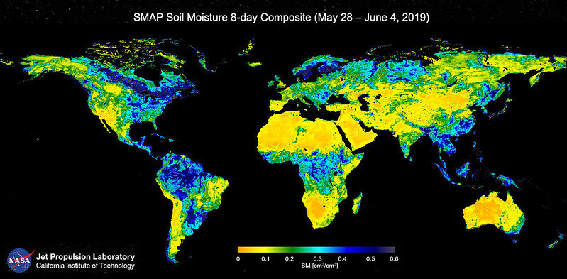
The NSIDC DAAC SMAP data collection includes data products derived from an L-band radiometer and high-resolution L-band radar instrument that make up the orbiting observatory of the Soil Moisture Active Passive (SMAP) satellite mission. The orbiting observatory measures surface soil conditions everywhere on Earth every two to three days, distinguishing between ground that is frozen or thawed. In ground that is not frozen or covered in water, SMAP measures how much water is in the top layer of soil, using this information to produce global maps of soil moisture.
When the SMAP mission began operating in April 2015, the radar and radiometer were integrated as a single observation system, designed to take concurrent and coincident measurements of surface emission and backscatter and to sense soil conditions through moderate vegetation cover. The radar provided active microwave remote sensing and the radiometer provided passive microwave remote sensing. However, in July 2015, the radar failed. Since then, measurements from the mission have solely come from the radiometer.
SMAP data can be used to enhance understanding of the global processes that link the water, carbon, and energy cycles, as well as to improve upon weather and climate prediction models. For example, scientists use SMAP data to:
- Improve flood warnings by assessing how wet soil is before rainstorms.
- Provide early warnings for drought by using SMAP data to identify soil moisture deficits.
- Improve crop yield forecasts, plan irrigation, and improve targeting of humanitarian food assistance around the world.
- Improve weather forecasts, as soil moisture is an important factor in predicting local and regional weather over a period of days and weeks.
The NSIDC SMAP collection includes Level-1 through Level-4 radiometer data, as well as Level-2 through Level-3 radar data and combined radar/radiometer data. SMAP Level-1 radar data are available at the Alaska Satellite Facility DAAC. The NSIDC DAAC also archives and distributes related SMAP validation campaign data and ancillary data.
SMAP validation studies
Extensive validation efforts characterize and document the accuracy and precision of SMAP observations and their derived products. All campaigns collected airborne L-band brightness temperature and backscatter; derived soil moisture; and in situ soil moisture, temperature, vegetation, and roughness measurements. Visit the SMAP Cal/Val Activities website for more details about past and future validation data and campaigns.
- CLASIC was a multidisciplinary interagency research effort designed to advance the understanding of how land surface processes influence cumulus convection. The experiments took place in 2007, prior to the start of the SMAP mission. While not a SMAP-specific experiment, CLASIC was relevant to the advancement of remote soil moisture sensing and the SMAP algorithm development.
- The SMAP Validation Experiment 2008 (SMAPVEX08) addressed issues related to the L3 soil moisture retrieval algorithms via a series of aircraft-based flights in Maryland and Delaware in September and October 2008.
- The SMAP Validation Experiment 2012 (SMAPVEX12) was designed to support soil moisture algorithms development by collecting a long time series of active-passive data under diverse and varying vegetation. Data were collected in Manitoba, Canada, from June to July 2012.
- The SMAP Validation Experiment 2015 (SMAPVEX15) was an aircraft-based campaign focusing on validating the downscaling algorithm process. The campaign took place in August 2015 in Arizona.
- The SMAP Validation Experiment 2016 (SMAPVEX16) took place from May to August 2016 in Manitoba, Canada. Its primary purpose was to address specific issues identified during the first year of SMAP post-launch and to contribute to improving the soil moisture algorithms.
- The SMAP Validation Experiment 2019 to 2022 (SMAPVEX19-22) took place from May 2019 to November 2022 and collected data in Massachusetts and New York. The primary objectives were to improve soil moisture and vegetation opacity retrieval in forests and to provide additional reference for SMAP/Sentinel-1 product validation.
- The SMAP/In Situ Core Site Validation Site Land Surface Parameters Match-Up Data is a single data product available at NSIDC. This data set contains in situ-based soil moisture estimates from numerous validation sites around the world. It is used to assess the performance of various SMAP soil moisture products.
SMAP Ancillary Data
NSIDC also archives ancillary data sets used to create SMAP science data products. The Level 1-3 ancillary data sets are used to create the SMAP L1, L2, and L3 products; the Level 4 ancillary data sets are used to create the SMAP L4 products. These ancillary data sets are made available as part of NSIDC DAAC’s mandate to preserve all SMAP data and related information for future research, per the NASA Earth Science Data Preservation Content Specification. Several of these ancillary data sets are produced by external organizations, such as NOAA, the NASA Global Modeling and Assimilation Office (GMAO), and NASA Land Data Assimilation Systems (LDAS). For more information about the creation and development of these data sets, users should refer to the originating institution.
Parameters
Antenna temperature, brightness temperature, soil moisture, freeze/thaw, surface soil moisture, gross primary production, net ecosystem carbon dioxide exchange, soil organic carbon, root zone soil moisture, surface soil moisture, soil classification, soil depth, soil porosity, soil texture, terrain elevation
Geographic coverage
Global
Related collections
Aquarius Level-2 and Level-3 Products
Soil Moisture Ocean Salinity (SMOS) Mission
Explore images from SMAP