SMMR and SSM/I-SSMIS
Overview
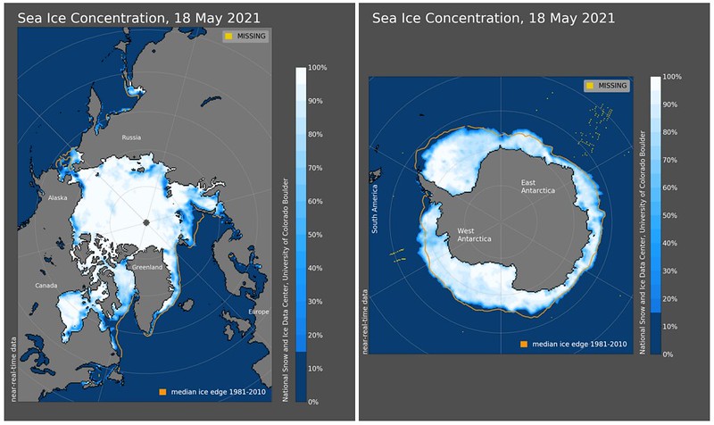
The NSIDC DAAC SMMR and SSM/I-SSMIS data collection includes near-global passive microwave data from 1978 to present. In addition to sea ice concentration and extent, the SMMR data collection includes data on sea surface temperatures, wind stress, snow cover, rainfall rates, and more, and the SSM/I and SSMIS collection includes data relating to brightness temperature, snow-covered area, snow cover, snow water equivalent, snow melt, sea ice motion, sea ice age, and more.
These data products are derived from the Scanning Multichannel Microwave Radiometer (SMMR) instrument on the Nimbus-7 satellite and the Special Sensor Microwave/Imager (SSM/I) and Special Sensor Microwave Imager/Sounder (SSMIS) and instruments on the Defense Meteorological Satellite Program's (DMSP) -F8, -F11, -F13, -F15, -F16, -F17, and -F18 satellites. The use of these instruments began the modern sea ice satellite record, following the Electrically Scanning Microwave Radiometer (ESMR), a single-frequency passive microwave instrument that operated from 1972 to 1977, and using multiple microwave frequencies to observe sea ice concentration and extent.
In combination, the data from SMMR, SSM/I, and SSMIS provides data users with the first consistent long-term climatology of polar sea ice, enabling them to track long-term trends of sea ice concentration and extent. This has allowed scientists to better understand the changes that have occurred in the Arctic and Antarctic over time since the satellite record began.
In addition to providing SMMR and SSM/I-SSMIS data to monitor and track sea ice concentration and extent, the NSIDC DAAC also hosts complementary data from the Advanced Microwave Scanning Radiometer Unified (AMSR-U) data collection which includes passive microwave data products on sea ice, snow, soil moisture, vegetation water content, and brightness temperature. Data are derived from the Advanced Scanning Microwave Radiometer for the NASA Earth Observing System (AMSR-E) and the Japanese Aerospace Exploration Agency’s AMSR2. The AMSR sensors are more advanced passive microwave instruments that provide more detailed information on sea ice conditions but lack the long-term consistent record of the SMMR-SSM/I-SSMIS products.
The NSIDC DAAC distributes Level-3 products, which range in temporal coverage from October 1978 to present. SMMR data are available from October 1978 through August 1987, when the Nimbus-7 SMMR scanner was shut off. SSM/I and SSMIS data are available from 1987 to present. These data products are offered in two projections: EASE-Grid and Polar Stereographic.
Parameters
Brightness temperature, snow-covered area, snow cover, snow water equivalent, snow melt, sea ice concentration, sea ice extent, sea ice motion, sea ice age
Spatial coverage
Global
Related collection(s)
Explore SMMR and SSM/I-SSMIS images